
Stakeholder-Informed Hydroclimate Scenario Modeling in the Lower Santa Cruz River Basin for Water Resource Management
 , , , and
Abstract
:1. Introduction
Co-Production of Hydroclimate Information
2. Study Methods
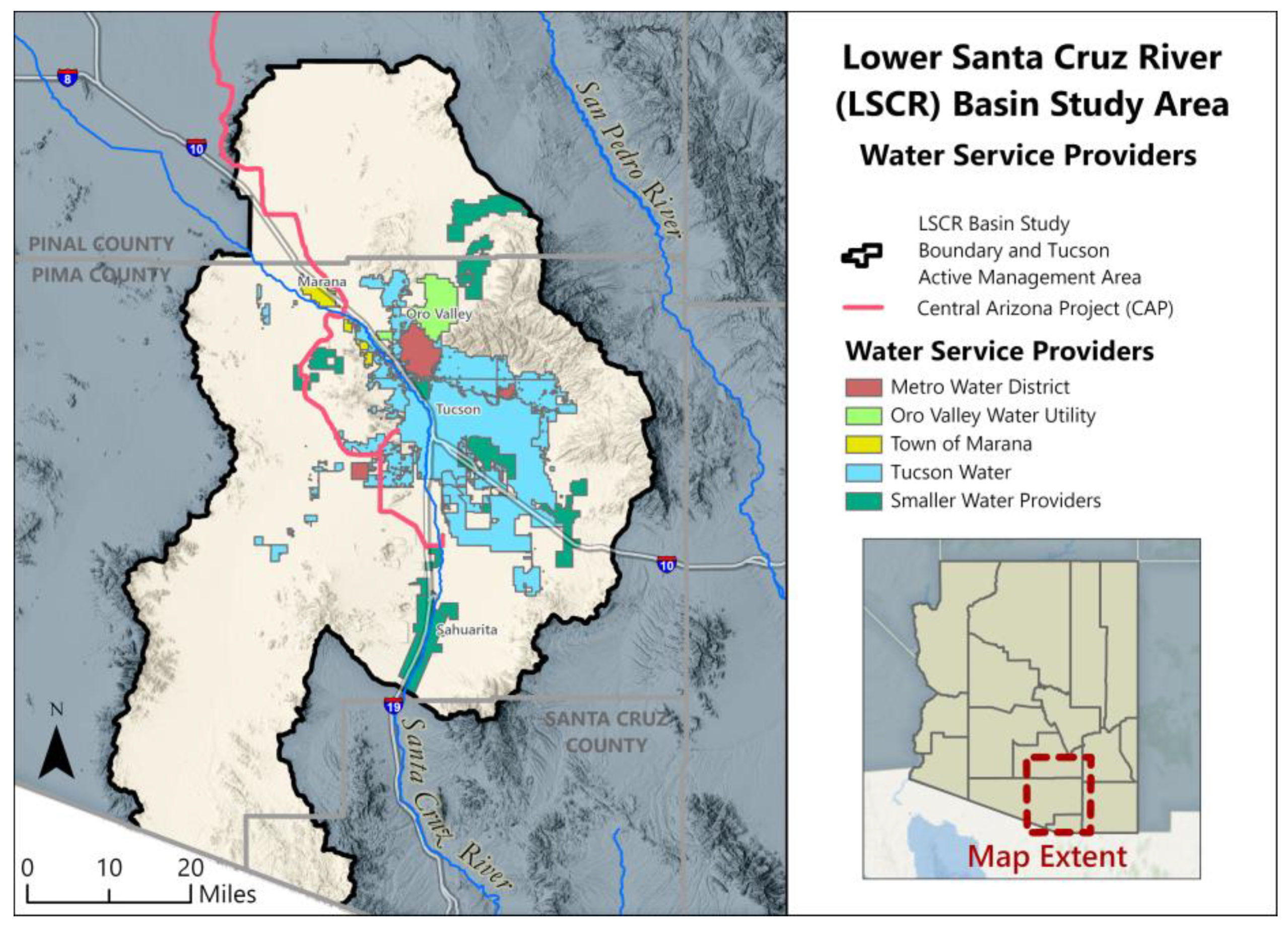
2.1. Study Area
2.2. Lower Santa Cruz River Basin Study
2.3. Hydroclimate Scenario Development
2.3.1. Climate Scenario Development
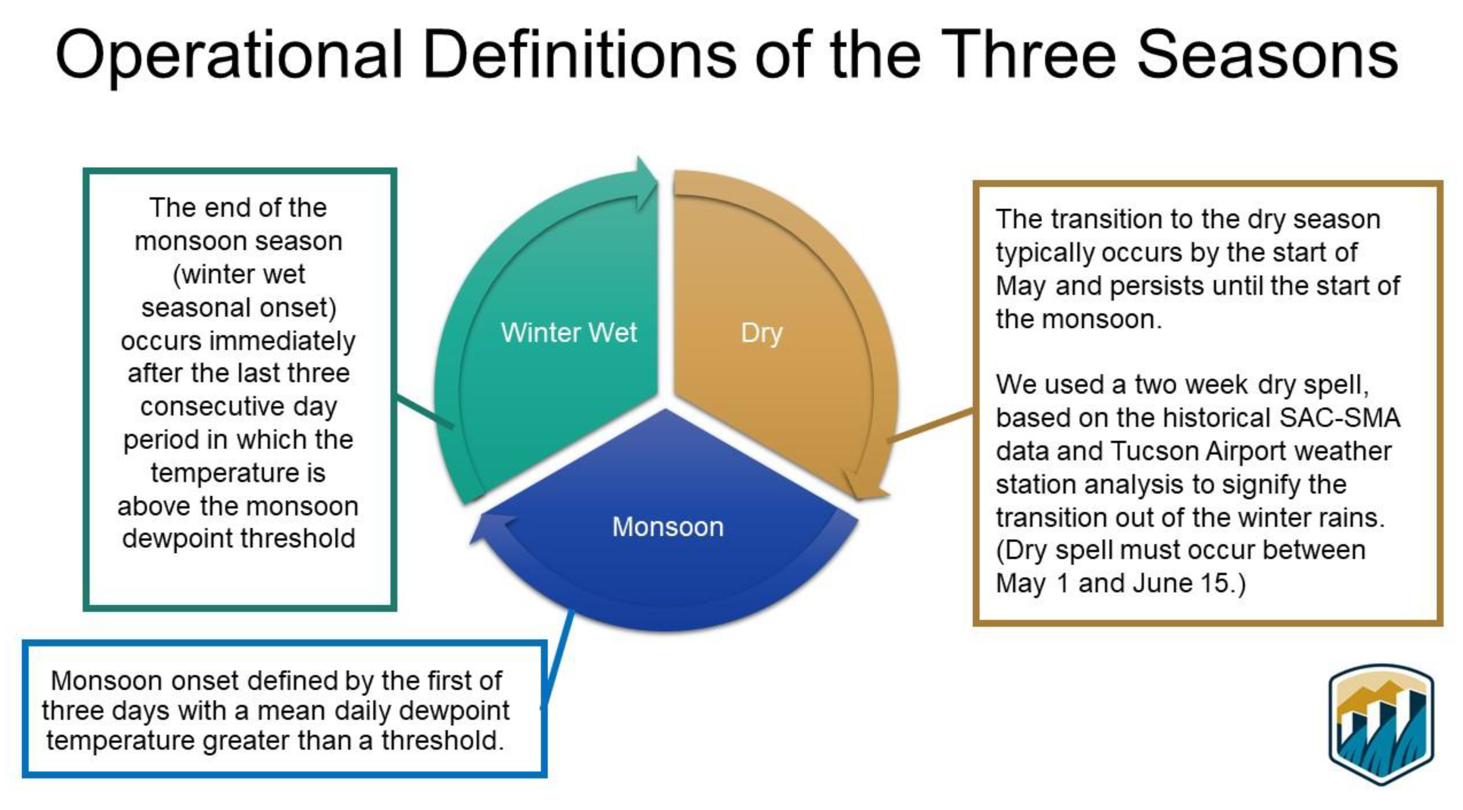
2.3.2. Seasonality
2.3.3. Weather Generator
2.3.4. Surface Water Modeling
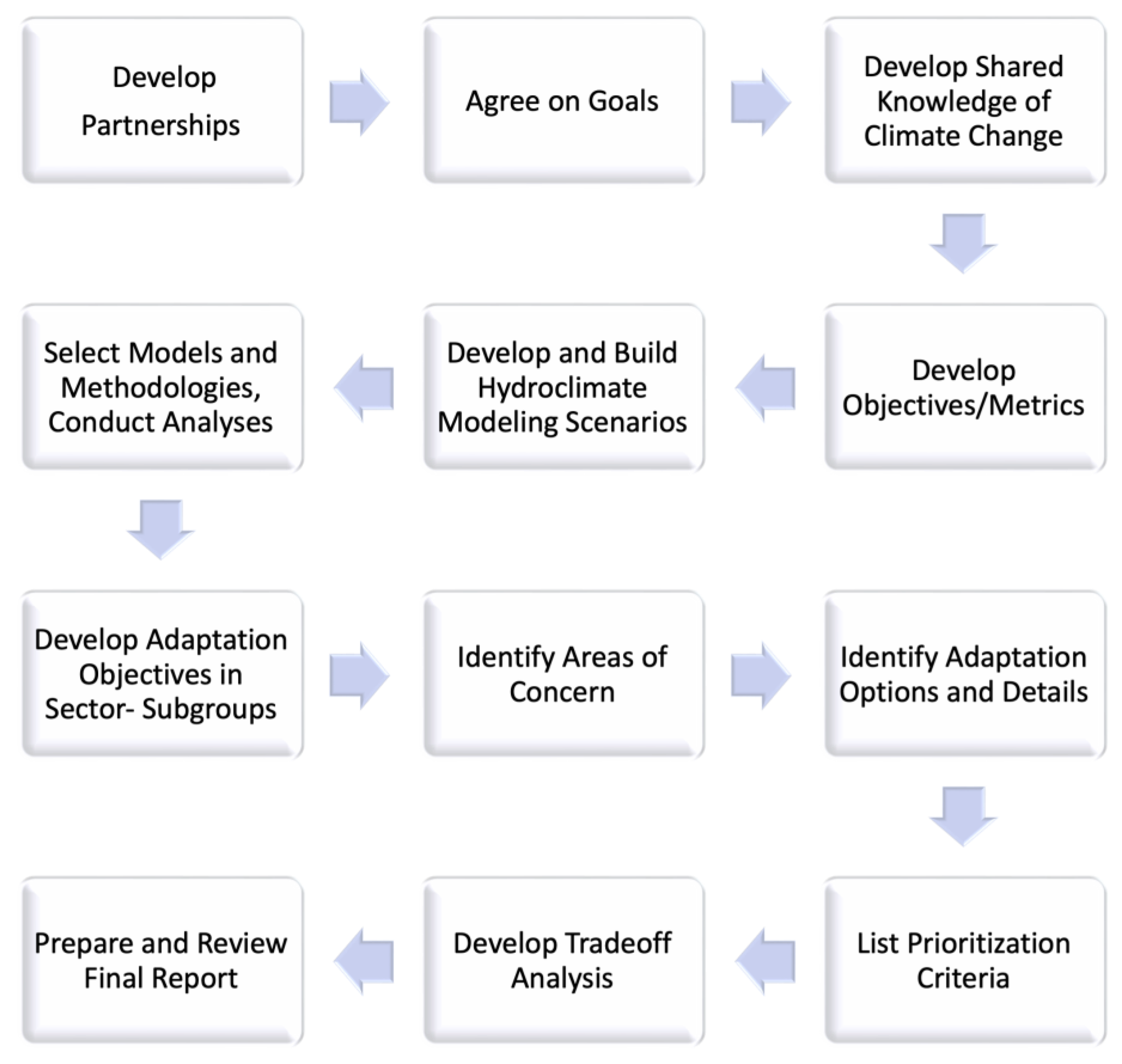
2.4. Stakeholder-Integrated Water Resources Evaluation
3. Results
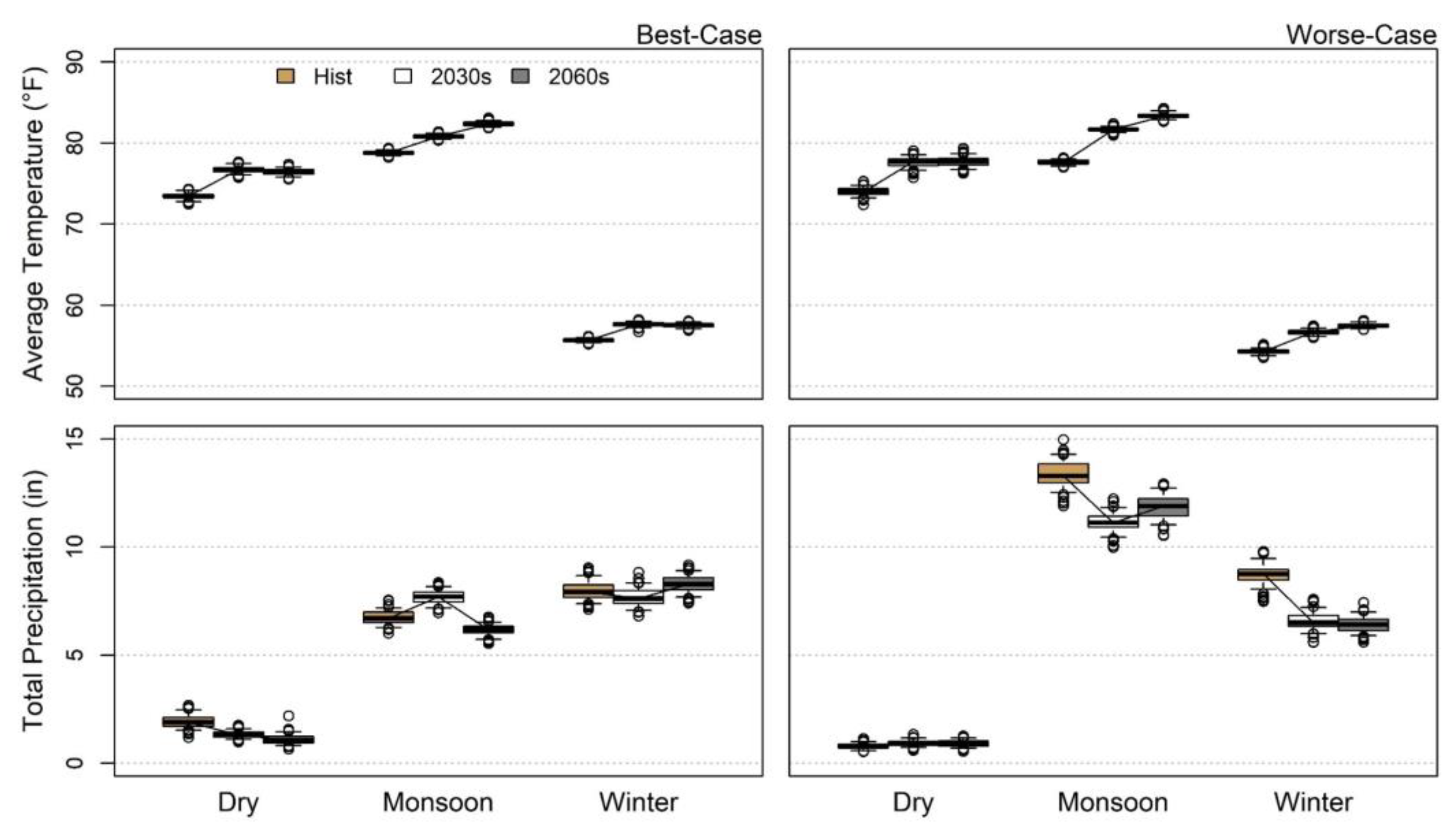
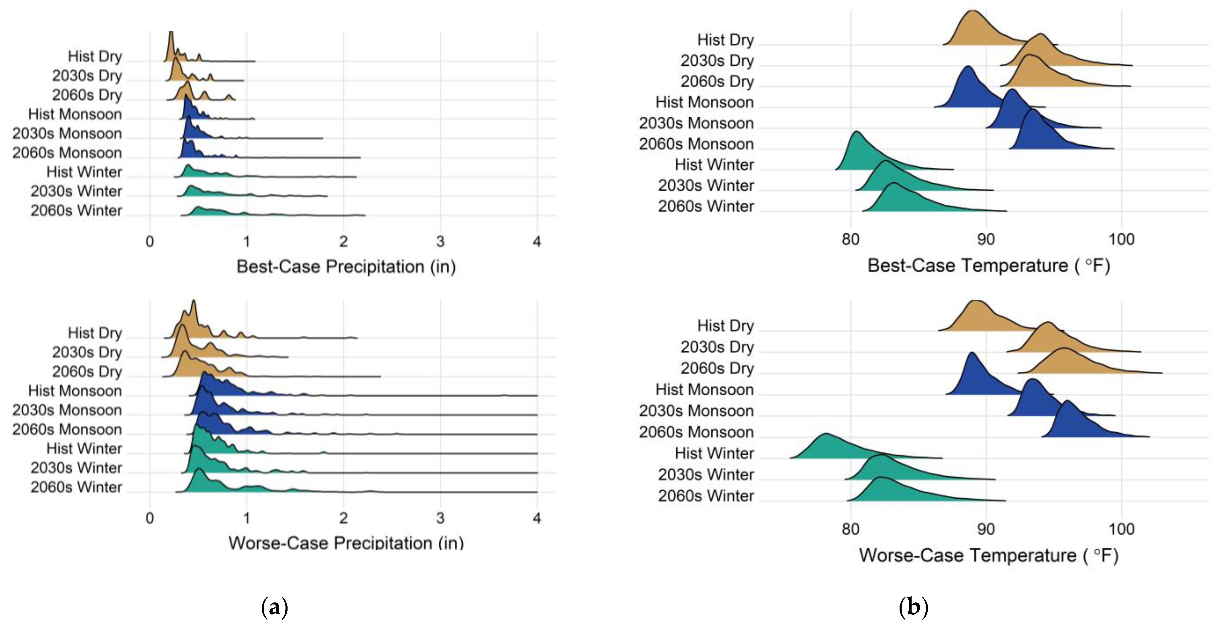
3.1. Hydroclimate Modeling with Environmental Implications
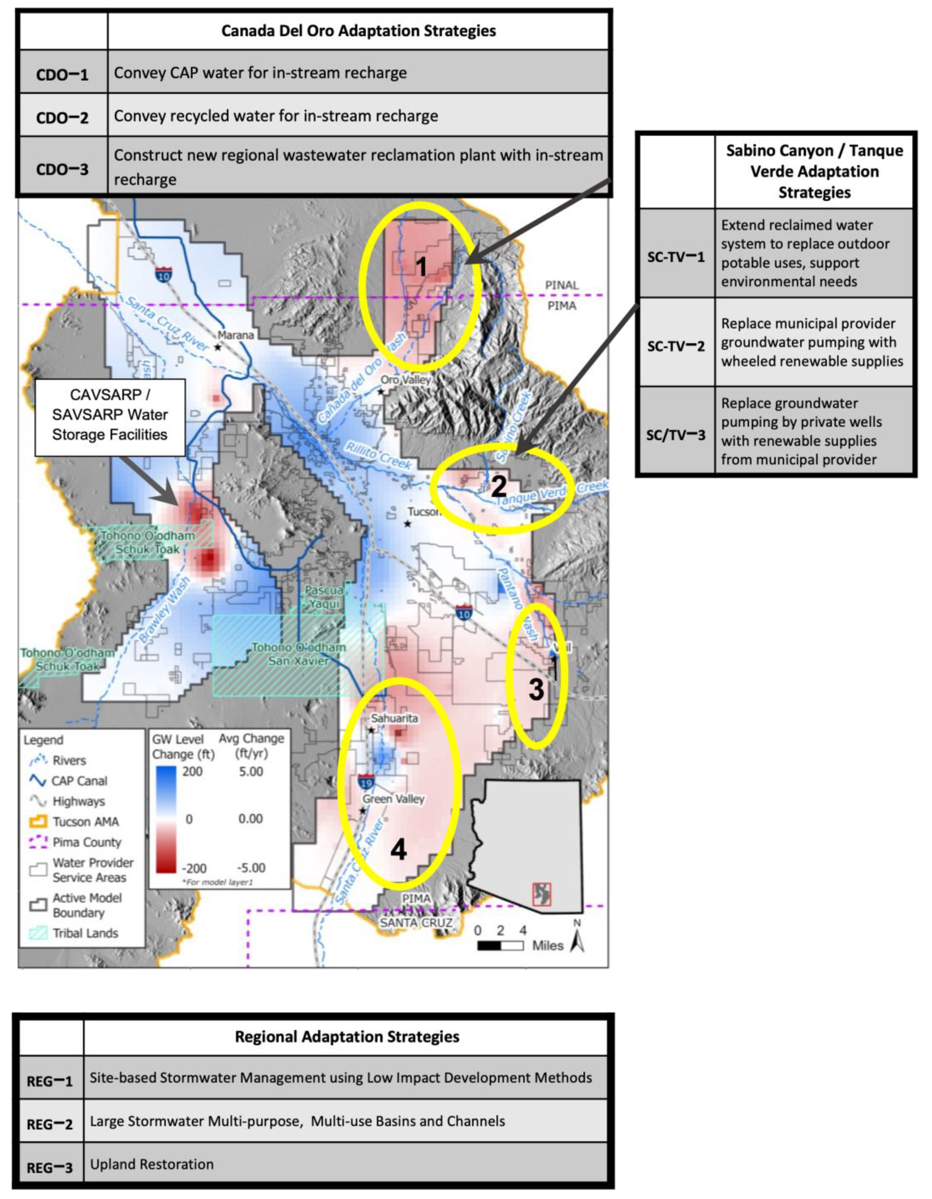
3.2. Development and Evaluation of Adaptation Strategies
4. Discussion
5. Conclusions
Author Contributions
Funding
Data Availability Statement
Acknowledgments
Conflicts of Interest
References
- Green, T.R.; Taniguchi, M.; Kooi, H.; Gurdak, J.J.; Allen, D.M.; Hiscock, K.M.; Treidel, H.; Aureli, A. Beneath the Surface of Global Change: Impacts of Climate Change on Groundwater. J. Hydrol. 2011, 405, 532–560. [Google Scholar] [CrossRef]
- Goderniaux, P.; Brouyère, S.; Wildemeersch, S.; Therrien, R.; Dassargues, A. Uncertainty of Climate Change Impact on Groundwater Reserves—Application to a Chalk Aquifer. J. Hydrol. 2015, 528, 108–121. [Google Scholar] [CrossRef]
- Buizer, J.; Jacobs, K.; Cash, D. Making Short-Term Climate Forecasts Useful: Linking Science and Action. Proc. Natl. Acad. Sci. USA 2016, 113, 4597–4602. [Google Scholar] [CrossRef] [PubMed]
- Jacobs, K.; Lebel, L.; Buizer, J.; Addams, L.; Matson, P.; McCullough, E.; Garden, P.; Saliba, G.; Finan, T. Linking Knowledge with Action in the Pursuit of Sustainable Water-Resources Management. Proc. Natl. Acad. Sci. USA 2016, 113, 4591–4596. [Google Scholar] [CrossRef]
- Star, J.; Rowland, E.L.; Black, M.E.; Enquist, C.A.F.; Garfin, G.; Hoffman, C.H.; Hartmann, H.; Jacobs, K.L.; Moss, R.H.; Waple, A.M. Supporting Adaptation Decisions through Scenario Planning: Enabling the Effective Use of Multiple Methods. Clim. Risk Manag. 2016, 13, 88–94. [Google Scholar] [CrossRef]
- Shamir, E.; Megdal, S.B.; Carrillo, C.; Castro, C.L.; Chang, H.I.; Chief, K.; Corkhill, F.E.; Eden, S.; Georgakakos, K.P.; Nelson, K.M.; et al. Climate Change and Water Resources Management in the Upper Santa Cruz River, Arizona. J. Hydrol. 2015, 521, 18–33. [Google Scholar] [CrossRef]
- Ky, R. Impact of Climate Change on Water Resources. J. Earth Sci. Clim. Change 2014, 5, 185. [Google Scholar] [CrossRef]
- Lemos, M.C.; Morehouse, B.J. The Co-Production of Science and Policy in Integrated Climate Assessments. Glob. Environ. Chang. 2005, 15, 57–68. [Google Scholar] [CrossRef]
- Djenontin, I.N.S.; Meadow, A.M. The Art of Co-Production of Knowledge in Environmental Sciences and Management: Lessons from International Practice. Environ. Manag. 2018, 61, 885–903. [Google Scholar] [CrossRef]
- Chegwidden, O.S.; Nijssen, B.; Rupp, D.E.; Arnold, J.R.; Clark, M.P.; Hamman, J.J.; Kao, S.C.; Mao, Y.; Mizukami, N.; Mote, P.W.; et al. How Do Modeling Decisions Affect the Spread Among Hydrologic Climate Change Projections? Exploring a Large Ensemble of Simulations Across a Diversity of Hydroclimates. Earth’s Futur. 2019, 7, 623–637. [Google Scholar] [CrossRef]
- Chiew, F.H.S.; Zheng, H.; Potter, N.J.; Charles, S.P.; Thatcher, M.; Ji, F.; Syktus, J.; Robertson, D.E.; Post, D.A. Different Hydroclimate Modelling Approaches Can Lead to a Large Range of Streamflow Projections under Climate Change: Implications for Water Resources Management. Water 2022, 14, 2730. [Google Scholar] [CrossRef]
- Martin, P.; Alexandra, J.; Holley, C.; Thoms, M. Murray-Darling Basin Plan Mark II. What Should Stakeholders Plan For? Aust. J. Water Resour. 2023, 1–12. [Google Scholar] [CrossRef]
- Wilder, M.; Scott, C.A.; Pablos, N.P.; Robert, G.; Garfin, G.M.; Mcevoy, J.; Wilder, M.; Scott, C.A.; Pablos, N.P.; Robert, G.; et al. Adapting across Boundaries: Climate Change, Border Region Adapting across Boundaries: Climate Change, Social Learning, and Resilience in the U.S.–Mexico Border Region. Ann. Assoc. Am. Geogr. 2010, 5608, 917–928. [Google Scholar] [CrossRef]
- Hair, J.; Black, W.; Babin, B.; Anderson, R. Multivariate Data Analysis; Prentice Hall: Upper Saddle River, NJ, USA, 2009. [Google Scholar]
- Freethey, G.W.; Anderson, T.W. Predevelopment Hydrologic Conditions in the Alluvial Basins of Arizona and Adjacent Parts of California and New Mexico; U.S. Geological Survey Hydrologic Investigations Atlas HA-664: Washington, DC, USA, 1986. [Google Scholar]
- Anderson, T.W.; Freethey, G.; Tucci, P. Geohydrology and Water Resources of Alluvial Basins in South-Central Arizona and Parts of Adjacent States. In Regional Aquifer System Analysis-Southwest Alluvial Basins, Arizona and Adjacent States; U.S. Geological Survey Professional Paper 1406-B: Washington, DC, USA, 1992. [Google Scholar]
- Mabry, J.B.; Davis, O.K.; Deaver, W.L.; Dutt, A.R.; Holmlund, J.P.; Kahn, J.; Mabry, J.B.; Miksa, E.J. Las Capas: Early Irrigation and Sedentism in a Southwestern Floodplain Edited by; Center for Desert Archeology: Tucson, Arizona, 2008. [Google Scholar]
- Minckley, W.L.; Miller, R.R.; Norris, S.M. Three New Pupfish Species, Cyprinodon (Teleostei, Cyprinodontidae), from Chihuahua, México, and Arizona, USA. Copeia 2002, 2002, 687–705. [Google Scholar] [CrossRef]
- Santa Cruz Watershed Collaborative (SCWC). Watershed Restoration Plan; Santa Cruz Watershed Collaborative: Tucson, Arizona, 2022. [Google Scholar]
- Sabo, J.L.; Sponseller, R.; Dixon, M.; Gade, K.; Harms, T.; Heffernan, J.; Jani, A.; Katz, G.; Soykan, C.; Watts, J.; et al. Riparian Zones Increase Regional Species Richness by Harboring Different, Not More, Species. Ecology 2005, 86, 56–62. [Google Scholar] [CrossRef]
- Fonseca, J.; Murray, I.; Ruther, S.; Neeley, J.; Webb, A.; Hammer, S. Pima County Multi-Species Conservation Plan 2021 Annual Report. Submitted to U.S. Fish and Wildlife Services; Pima County: Tucson, Arizona, 2021. [Google Scholar]
- Bark, R.H.; Osgood, D.E.; Colby, B.G.; Katz, G.; Stromberg, J. Habitat Preservation and Restoration: Do Homebuyers Have Preferences for Quality Habitat? Ecol. Econ. 2009, 68, 1465–1475. [Google Scholar] [CrossRef]
- Bark, R.; Osgood, D.; Colby, B.; Halper, E. How Do Homebuyers Value Different Types of Green Space? J. Agric. Resour. Econ. 2011, 36, 395–415. [Google Scholar] [CrossRef]
- Hill, E.; Fonseca, J. Groundwater Level Changes in the Tanque Verde Valley. Update; Pima County Administrator’s Office: Tucson, Arizona, 2002. [Google Scholar]
- Thompson, D.; Herman, V. World Water; Water Environment Federations: Washington, DC, USA, 2020. [Google Scholar]
- Hendrickson, D.; Minckley, W. Cienegas: Vanishing Climax Communities of the American Southwest. Desert Plants 1985, 6, 130–176. [Google Scholar]
- Webb, R.H.; Betancourt, J.L.; Johnson, R.R.; Turner, R.M. Requiem for the Santa Cruz. University of Arizona Press: Tucson, AZ, USA, 2014; ISBN 9780816530724. [Google Scholar]
- Stromberg, J.C.; Mcclimey, K.E.; Dixon, M.D.; Meixner, T. Dryland Riparian Ecosystems in the American Southwest: Extremes. Ecosystems 2013, 16, 411–415. [Google Scholar] [CrossRef]
- Bureau of Reclamation. Hydroclimate Analysis Lower Santa Cruz River Basin Study, Technical Memorandum No. ENV-2021-035; Bureau of Reclamation Technical Service Center: Denver, Colorado, 2021. [Google Scholar]
- Moss, R.H.; Edmonds, J.A.; Hibbard, K.A.; Manning, M.R.; Rose, S.K.; Van Vuuren, D.P.; Carter, T.R.; Emori, S.; Kainuma, M.; Kram, T.; et al. The next Generation of Scenarios for Climate Change Research and Assessment. Nature 2010, 463, 747–756. [Google Scholar] [CrossRef]
- van Vuuren, D.P.; Edmonds, J.; Kainuma, M.; Riahi, K.; Thomson, A.; Hibbard, K.; Hurtt, G.C.; Kram, T.; Krey, V.; Lamarque, J.F.; et al. The Representative Concentration Pathways: An Overview. Clim. Change 2011, 109, 5–31. [Google Scholar] [CrossRef]
- Mukherjee, R. Implications of Statistical and Dynamical Downscaling Methods on Streamflow Projections for the Colorado River Basin in the Graduate College, University of Arizona; The University of Arizona University Libraries: Tucson, AZ, USA, 2016. [Google Scholar]
- Cook, B.I.; Seager, R. The Response of the North American Monsoon to Increased Greenhouse Gas Forcing. J. Geophys. Res. Atmos. 2013, 118, 1690–1699. [Google Scholar] [CrossRef]
- Almazroui, M.; Islam, M.N.; Saeed, F.; Saeed, S.; Ismail, M.; Ehsan, M.A.; Diallo, I.; O’Brien, E.; Ashfaq, M.; Martínez-Castro, D.; et al. Projected Changes in Temperature and Precipitation Over the United States, Central America, and the Caribbean in CMIP6 GCMs. Earth Syst. Environ. 2021, 5, 1–24. [Google Scholar] [CrossRef]
- Sheffield, J.; Barrett, A.P.; Colle, B.; Fernando, D.N.; Fu, R.; Geil, K.L.; Hu, Q.; Kinter, J.; Kumar, S.; Langenbrunner, B.; et al. North American Climate in CMIP5 Experiments. Part I: Evaluation of Historical Simulations of Continental and Regional Climatology. J. Clim. 2013, 26, 9209–9245. [Google Scholar] [CrossRef]
- Pierce, D.W.; Cayan, D.R.; Thrasher, B.L. Statistical Downscaling Using Localized Constructed Analogs (LOCA). J. Hydrometeorol. 2014, 15, 2558–2585. [Google Scholar] [CrossRef]
- Tillman, F.D.; Gangopadhyay, S.; Pruitt, T. Trends in Recent Historical and Projected Climate Data for the Colorado River Basin and Potential Effects on Groundwater Availability; U.S. Geological Survey Scientific Investigations Report 2020–5107; U.S. Geological Survey: Reston, VA, USA, 2020. [Google Scholar]
- Ellis, A.W.; Saffell, E.M.; Hawkins, T.W. A Method for Defining Monsoon Onset and Demise in the Southwestern USA. Int. J. Climatol. 2004, 24, 247–265. [Google Scholar] [CrossRef]
- Crimmins, M.; Doster, S.; Mcmahan, B. September Southwest Climate Outlook; Climate Assessment for the Southwest: Tucson, Arizona, 2015. [Google Scholar]
- Gallo, E.L.; Brooks, P.D.; Lohse, K.A.; Mclain, J.E.T. Temporal Patterns and Controls on Runoff Magnitude and Solution Chemistry of Urban Catchments in the Semiarid Southwestern United States. Hydrol. Process. 2013, 27, 995–1010. [Google Scholar] [CrossRef]
- Gelt, J.; Henderson, J.; Seashole, K.; Tellman, B.; Woodard, G.; Carpenter, K.; Hudson, C.; Sherif, S. Water in the Tucson Area: Seeking Sustainability; Water Resources Research Center: Tucson, Arizona, 1999. [Google Scholar]
- McMahan, B.; Granillo, R.L.; Delgado, B.; Herrera, M.; Crimmins, M.A. Curating and Visualizing Dense Networks of Monsoon Precipitation Data: Integrating Computer Science into forward Looking Climate Services Development. Front. Clim. 2021, 3, 602573. [Google Scholar] [CrossRef]
- Shamir, E.; Halper, E. Estimating Climatic Change Impacts on Water Resources in Arid Environments: The Role of Downscaling Methodology; Bureau of Reclamation Research and Development Office: Denver, Colorado, 2019. [Google Scholar]
- Hamon, W.R. Computation of Direct Runoff Amounts from Storm Rainfall. Int. Assoc. Sci. Hydrol. Publ. 1963, 63, 52–62. Available online: https://iahs.info/uploads/dms/063006.pdf (accessed on 24 March 2023).
- Bureau of Reclamation. Lower Santa Cruz River Basin Study Groundwater Analysis, Technical Memorandum ENV-2021-64; Bureau of Reclamation Technical Service Center: Denver, Colorado, 2021. [Google Scholar]
- Meadow, A.M.; Ferguson, D.B.; Guido, Z.; Horangic, A.; Owen, G.; Wall, T. Moving toward the Deliberate Coproduction of Climate Science Knowledge. Weather. Clim. Soc. 2015, 7, 179–191. [Google Scholar] [CrossRef]
- Jacobs, K.L.; Street, R.B. The next Generation of Climate Services. Clim. Serv. 2020, 20, 100199. [Google Scholar] [CrossRef]
- Saliba, G.; Jacobs, K.L. Saving the San Pedro River: Science, Collaboration, and Water Sustainability in Arizona. Environment 2008, 50, 30–43. [Google Scholar] [CrossRef]
- Poff, N.L.; Allan, J.D.; Bain, M.B.; Karr, J.R.; Karen, L.; Richter, B.D.; Sparks, R.E.; Stromberg, J.C.; Poff, N.L.; Allan, J.D.; et al. The Natural Flow Regime: A Paradigm for River Conservation and Restoration. BioScience 1997, 47, 769–784. [Google Scholar] [CrossRef]
- Levick, L.R.; Goodrich, D.C.; Hernandez, M.; Fonseca, J.; Semmens, D.J.; Stromberg, J.; Tluczek, M.; Leidy, R.A.; Scianni, M.; Guertin, P.D.; et al. The Ecological and Hydrological Significance of Ephemeral and Intermittent Streams in the Arid and Semi-Arid American Southwest; EPA/600/R-08/134,ARD/233046; US Environmental Protection Agency and USDA/ARS Southwest Watershed Research Center: Washington, DC, USA, 2008; pp. 1–116. [Google Scholar]
- Larned, S.T.; Datry, T.; Arscott, D.B.; Tockner, K. Emerging Concepts in Temporary-River Ecology. Freshw. Biol. 2010, 55, 717–738. [Google Scholar] [CrossRef]
- Weiss, J.L.; Castro, C.L.; Overpeck, J.T. Distinguishing Pronounced Droughts in the Southwestern United States: Seasonality and Effects of Warmer Temperatures. J. Clim. 2009, 22, 5918–5932. [Google Scholar] [CrossRef]
- Magliano, P.N.; Giménez, R.; Houspanossian, J.; Páez, R.A.; Nosetto, M.D.; Fernández, R.J.; Jobbágy, E.G. Litter Is More Effective than Forest Canopy Reducing Soil Evaporation in Dry Chaco Rangelands. Ecohydrology 2017, 10, 1879. [Google Scholar] [CrossRef]
- Breshears, D.D.; Cobb, N.S.; Rich, P.M.; Price, K.P.; Allen, C.D.; Balice, R.G.; Romme, W.H.; Kastens, J.H.; Floyd, M.L.; Belnap, J.; et al. Regional Vegetation Die-off in Response to Global-Change-Type Drought. Proc. Natl. Acad. Sci. USA 2005, 102, 15144–15148. [Google Scholar] [CrossRef]
- Novick, K.A.; Ficklin, D.L.; Stoy, P.C.; Williams, C.A.; Bohrer, G.; Oishi, A.C.; Papuga, S.A.; Blanken, P.D.; Noormets, A.; Sulman, B.N.; et al. The Increasing Importance of Atmospheric Demand for Ecosystem Water and Carbon Fluxes. Nat. Clim. Chang. 2016, 6, 1023–1027. [Google Scholar] [CrossRef]
- Dannenberg, M.P.; Yan, D.; Barnes, M.L.; Smith, W.K.; Johnston, M.R.; Scott, R.L.; Biederman, J.A.; Knowles, J.F.; Wang, X.; Duman, T.; et al. Exceptional Heat and Atmospheric Dryness Amplified Losses of Primary Production during the 2020 U.S. Southwest Hot Drought. Glob. Chang. Biol. 2022, 28, 4794–4806. [Google Scholar] [CrossRef]
- Luong, T.M.; Castro, C.L.; Chang, H.I.; Lahmers, T.; Adams, D.K.; Ochoa-Moya, C.A. The More Extreme Nature of North American Monsoon Precipitation in the Southwestern United States as Revealed by a Historical Climatology of Simulated Severe Weather Events. J. Appl. Meteorol. Climatol. 2017, 56, 2509–2529. [Google Scholar] [CrossRef]
- Ghazavi, R.; Ebrahimi, H. Predicting the Impacts of Climate Change on Groundwater Recharge in an Arid Environment Using Modeling Approach. Int. J. Clim. Chang. Strateg. Manag. 2019, 11, 88–99. [Google Scholar] [CrossRef]
- Ajami, H.; Meixner, T.; Dominguez, F.; Hogan, J.; Maddock, T. Seasonalizing Mountain System Recharge in Semi-Arid Basins-Climate Change Impacts. Ground Water 2012, 50, 585–597. [Google Scholar] [CrossRef] [PubMed]
- Marchane, A.; Tramblay, Y.; Hanich, L.; Ruelland, D.; Jarlan, L. Climate Change Impacts on Surface Water Resources in the Rheraya Catchment (High Atlas, Morocco). Hydrol. Sci. J. 2017, 62, 979–995. [Google Scholar] [CrossRef]
- Singletary, L.; Sterle, K. Supporting Local Adaptation through the Co-Production of Climate Information: An Evaluation of Collaborative Research Processes and Outcomes. Clim. Serv. 2020, 20, 100201. [Google Scholar] [CrossRef]
- Lemos, M.C.; Kirchhoff, C.J.; Ramprasad, V. Narrowing the Climate Information Usability Gap. Nat. Clim. Chang. 2012, 2, 789–794. [Google Scholar] [CrossRef]
- Lemos, M.C.; Kirchhoff, C.J.; Kalafatis, S.E.; Scavia, D.; Rood, R.B. Moving Climate Information off the Shelf: Boundary Chains and the Role of Risas as Adaptive Organizations. Weather. Clim. Soc. 2014, 6, 273–285. [Google Scholar] [CrossRef]
- Browning-Aiken, A.; Morehouse, B.; Davis, A.; Wilder, M.; Varady, R.; Goodrich, D.; Carter, R.; Moreno, D.; McGovern, E.D. Climate, Water Management, and Policy in the San Pedro Basin: Results of a Survey of Mexican Stakeholders near the U.S.-Mexico Border. Clim. Change 2007, 85, 323–341. [Google Scholar] [CrossRef]
- Webb, R.H.; Leake, S.A. Ground-Water Surface-Water Interactions and Long-Term Change in Riverine Riparian Vegetation in the Southwestern United States. J. Hydrol. 2006, 320, 302–323. [Google Scholar] [CrossRef]
- Mccoy, A.L.; Jacobs, K.L.; Vano, J.A.; Wilson, J.K.; Martin, S.; Pendergrass, A.G.; Cifelli, R. The Press and Pulse of Climate Change: Extreme Events in the Colorado River Basin. JAWRA J. Am. Water Resour. Assoc. 2022, 58, 1076–1097. [Google Scholar] [CrossRef]
- Poupeau, F.; Gupta, H.; Serrat-Capdevila, A.; Sans-Fuentes, M.A.; Harris, S.; Hayde, L.G. Water Bankruptcy in the Land of Plenty; Taylor & Francis Group: New York, NY, USA, 2016; ISBN 9781498776998. [Google Scholar]
- Marshall, R.M.; Robles, M.D.; Majka, D.R.; Haney, J.A. Sustainable Water Management in the Southwestern United States: Reality Ors Rhetoric? PLoS ONE 2010, 5, 11687. [Google Scholar] [CrossRef]
- Dee, N.; Baker, J.K.; Drobny, N.L.; Duke, K.M.; Whitman, I.L.; Fahringer, D. An Environmental Evaluation System for Water Resource Planning. Water Resour. Res. 1973, 9, 523–535. [Google Scholar] [CrossRef]
- Browning-Aiken, A.; Ormerod, K.J.; Scott, C.A. Testing the Climate for Non-Potable Water Reuse: Opportunities and Challenges in Water-Scarce Urban Growth Corridors. J. Environ. Policy Plan. 2011, 13, 253–275. [Google Scholar] [CrossRef]
- Gerlak, A.K.; Elder, A.; Thomure, T.; Shipek, C.; Pavao-zuckerman, M.; Gupta, N.; Matsler, M.; Henry, A.D.; Yang, B.; Murrieta-saldivar, J.; et al. Green Infrastructure: Lessons in Governance and Collaboration from Tucson. Environ. Sci. Policy Sustain. Dev. 2021, 63, 15–24. [Google Scholar] [CrossRef]
- Daigger, G.T. Evolving Urban Water and Residuals Management Paradigms: Water Reclamation and Reuse, Decentralization, Resource Recovery. Water Environ. Res. 2009, 81, 809–823. [Google Scholar] [CrossRef] [PubMed]


| Adaptation Objective | Description |
|---|---|
| Enhances or protects high-value habitat | Prioritize consideration of areas that include those with mature trees, high aesthetic value, biodiversity, refugia, biological cores, rarity, and large landscape size. |
| Promotes landscape connectivity | Enhances and/or does not impair landscape connectivity in the context of wildlife species support, such as corridors for migration. |
| Protects water quality | Protects and/or does not impair water quality |
| Promotes accessible recreational opportunities | Promote consideration of strategies in areas that are accessible to visitors and/or provide recreational opportunities, including public lands. |
| Enhances or protects cultural/heritage values | Dedicate careful consideration of adaptation strategies in areas with human connections to landscape of regional inhabitants, including tribal concerns and heritage values, and ecosystem services related to cultural or spiritual connection to landscape. |
| Reduces flood risk | Promote consideration of strategies with focus on preservation and/or restoration of floodplain function and ecosystem services. |
| Projections | Summary Metrics |
|---|---|
| Precipitation | Basin average; top 10% |
| Temperature | Basin average; top 10%, bottom 10% |
| Streamflow | Predicted change in annual runoff at various concentration points; fractional change; top 5 increase in no-flow days; top 5 changes in soil moisture |
| (a) | ||||
|---|---|---|---|---|
| Best Case—2030s “Near Future” | Best Case—2060s “Far Future” | Worse Case—2030s “Near Future” | Worse Case—2060s “Far Future” | |
| Change in average annual temperature | 2.94° F | 3.83° F | 3.41° F | 5.12° F |
| Change in average dry season temperature | 2.59° F | 2.31° F | 3.44° F | 3.34° F |
| Change in average monsoon temperature | 1.96° F | 3.52° F | 4.24° F | 5.81° F |
| Change in average winter temperature | 1.88° F | 1.85° F | 2.45° F | 3.20° F |
| (b) | ||||
| Best Case—2030s “Near Future” | Best Case—2060s “Far Future” | Worse Case—2030s “Near Future” | Worse Case—2060s “Far Future” | |
| Change in total annual precipitation | 0.32″ | −0.85″ | −4.34″ | −3.90″ |
| Change in average monsoon precipitation | 0.80″ | −0.87″ | −2.38″ | −1.57″ |
| Change in average winter precipitation | −0.21″ | 0.57″ | −2.25″ | −2.38″ |
| Strategy Acronym | Strategy Name | Description | Environmental Benefits |
|---|---|---|---|
| CDO-1 | CAP water to CDO area with in-stream recharge | Construct pump stations and a pipeline to convey water from the Central Arizona Project (CAP) Red Rock Pumping Plant to the Cañada del Oro (CDO) wash area for in-stream recharge. | In-stream recharge; riparian health; promote recreation |
| CDO-2 | SCR reclaimed to CDO area with in-stream recharge | Construct pump stations and a pipeline to convey reclaimed water in the Santa Cruz River (SCR) past Trico Road to the Cañada del Oro (CDO) wash area for in-stream recharge. Includes treatment for PFAS and 1,4 dioxane. | In-stream recharge; riparian health; promote recreation |
| CDO-3 | Saddlebrooke area sub-regional WRF with in-stream recharge | Construct a new sub-regional wastewater reclamation facility (WRF) in the Saddlebrooke area with a pipeline for in-stream recharge. | In-stream recharge; riparian health; promote recreation |
| SC-TV-1 | Tucson Water RECLAIMED SYSTEM EXTENSION to Isabella Lee Preserve and other sites | Extend Tucson Water (TW) reclaimed water pipeline to replace outdoor use of potable water at new sites and support irrigation at Isabella Lee Preserve. | Reduce groundwater overdraft; riparian health; promote recreation |
| SC-TV-2 | Wheel Tucson Water renewable supplies to metro water district hub service area | Use existing and new infrastructure to connect the Metro Water District’s Hub Service Area to the Tucson Water central potable system. Wheel renewable supplies, replace need for local groundwater pumping. | Reduce groundwater overdraft; riparian health |
| SC-TV-3 | Tucson Water renewable supplies to exempt well owners | Connect exempt well owners to Tucson Water central potable system to provide renewable supplies, retire exempt wells. | Reduce groundwater overdraft; riparian health; promote recreation |
| REG-1 | Stormwater management using low-impact development | Retrofit existing properties and incorporate low-impact development (LID) features into new developments to harvest and use stormwater at the residential scale. Build-out takes place from 2020–2060. | Flood control; terrestrial ecosystem health |
| REG-2 | Stormwater multi-purpose, multi-use basins and channels | Construct large multi-benefit retention and detention basins and channels to collect and slow stormwater from impervious areas for flood mitigation, storage and/or habitat restoration | Flood control; terrestrial ecosystem health |
| REG-3 | Stormwater management using upland restoration | Perform upland restoration using small, distributed features to restore, protect and enhance surface water resources. May provide improved infiltration and soil moisture and restore groundwater levels. | In-stream recharge; riparian health; promote recreation |
Disclaimer/Publisher’s Note: The statements, opinions and data contained in all publications are solely those of the individual author(s) and contributor(s) and not of MDPI and/or the editor(s). MDPI and/or the editor(s) disclaim responsibility for any injury to people or property resulting from any ideas, methods, instructions or products referred to in the content. |
© 2023 by the authors. Licensee MDPI, Basel, Switzerland. This article is an open access article distributed under the terms and conditions of the Creative Commons Attribution (CC BY) license (https://creativecommons.org/licenses/by/4.0/).
Share and Cite
Gupta, N.; Bearup, L.; Jacobs, K.; Halper, E.; Castro, C.; Chang, H.-I.; Fonseca, J. Stakeholder-Informed Hydroclimate Scenario Modeling in the Lower Santa Cruz River Basin for Water Resource Management. Water 2023, 15, 1884. https://doi.org/10.3390/w15101884
Gupta N, Bearup L, Jacobs K, Halper E, Castro C, Chang H-I, Fonseca J. Stakeholder-Informed Hydroclimate Scenario Modeling in the Lower Santa Cruz River Basin for Water Resource Management. Water. 2023; 15(10):1884. https://doi.org/10.3390/w15101884
Chicago/Turabian StyleGupta, Neha, Lindsay Bearup, Katharine Jacobs, Eve Halper, Chris Castro, Hsin-I Chang, and Julia Fonseca. 2023. "Stakeholder-Informed Hydroclimate Scenario Modeling in the Lower Santa Cruz River Basin for Water Resource Management" Water 15, no. 10: 1884. https://doi.org/10.3390/w15101884