
Water Sensitive Planning for the Cities in the Global South

1
Department of Physical Planning, School of Planning and Architecture, New Delhi 110002, India
2
School of Architecture, Planning and Landscape, Newcastle University, Newcastle Upon Tyne NE1 7RU, UK
3
School of Engineering, Newcastle University, Newcastle Upon Tyne NE1 7RU, UK
*
Author to whom correspondence should be addressed.
Water 2023, 15(2), 235; https://doi.org/10.3390/w15020235
Submission received: 3 October 2022
/
Revised: 24 December 2022
/
Accepted: 3 January 2023
/
Published: 5 January 2023
Abstract
:Water Sensitive Planning (WSP) recognizes the centrality of water in the urban built environment, something often overlooked in urban planning systems. WSP was primarily developed for western city contexts but many cities in the Global South are rapidly urbanizing, and informal settlements are the predominant form of development, with limited existing water provision. A new WSP framework is needed for these contexts. This paper envisions what a WSP theory would look like for a city in the Global South to enhance water security, using Delhi as a starting point. Firstly, the substantive components of WSP are identified from the literature. Secondly, this framework is critiqued with respect to the extent to which it is appropriate for planning rapidly urbanizing cities, especially in India. Finally, the key principles of WSP for cities in the Global South are suggested. Notable principles include integration of water planning and city planning; linking of drains with statute protected water bodies; green places as recharge areas; reuse of adequately treated wastewater for irrigation purposes; and building roads and drains as per hydrogeography of a place.
1. Introduction
Traditional urban planning and development policies are often viewed as unsustainable growth models, promoting environmental threats, and economic and social distresses [1]. Growing evidence on global environmental challenges and the emergence of the paradigm of ‘sustainable development’ as a potential solution targeting urban form further supports our focus on Water Sensitive Planning (WSP) in the cities of the Global South. Many scholars [1,2,3,4,5] have extensively contributed to our understanding about sustainable urban forms such as green urbanism, compact city, urban containment and eco-cities, etc. Attributes of these approaches include high density of built-up areas, urban intensification, mixed land uses, effective transportation and communication systems, accessibility to city functions, and limits to urban growth.
Most of the literature has emerged from the western context, primarily from Australia, United Kingdom, the Netherlands, and Israel, which is not entirely suited to planning of rapidly urbanizing Southern cities. This means that the issues pertaining to stormwater are of major focus in the current Water Sensitive Planning and Water Sensitive Urban Design (WSUD) literature, whereas actual planning processes are not discussed. Large-sized informally-built cities of the Global South with inadequate infrastructure such as drains and roads, low municipal budgets, low institutional capacities, and misrecognition of citizenship are clearly major aspects that remain unaddressed by the currently existing WSP approach. Accepting the distinctive nature of the southern urbanism, scholars [6] argue that a separate theory of water sensitive planning is needed because there appears to be a lack of communication between scholars of the Global North and South. Even among western scholars, cross-fertilization of ideas to generate a coherent set of principles for building water sensitive planning approach is not happening. Thus, this paper aims to address this gap by suggesting global principles for placing water at the centre of urban planning processes.
Departing from the traditional focus of planning, a water sensitive planning decentres city planners’ sole focus is on land and reorients it towards water, creating a situation whereby equal emphasis is placed on land and water, viewing them as conjoined elements. New pathways are found through the identification of substantive and processual components whereby city planners and water planners continuously speak to each other. As masterfully explained below:
“Linkages between water management and spatial planning occur in different ways. Water pollution is often created on land. Urban development is often restricted, or motivated, by the presence or lack of water. Some kinds of land uses, such as dense urban development, can actually cause flooding. Agricultural or industrial land use may deplete ground water, degrade water quality, or drain naturally wet areas. Clearly, water management and spatial planning are inherently connected. Yet they are traditionally separated for policymaking”[7] (p. 213).
So, integration of water planning and city planning is the primary goal of water sensitive planning. The second most significant goal of water sensitive planning is water security obtained through sustainable use of rainwater, groundwater, surface water, and reuse of wastewater (see Figure 1). Third, underpinning the substantive aspects of water sensitive planning are processual components such as spatial integration, coproduction through citizen engagement, conflict management, uncertainty of contexts, power and control, and interconnectedness of humans and the environment. Here, the substantive components mean the goals of the WSP, whereas the processual components are processes that underpin effective achievement of substantive goals.
This paper critically reviews the literature on the WSP from the Global North with its relevance in the Global South. An extensive secondary literature review exercise was carried out for reviewing the existing literature and simultaneously linking it to the cases from the southern cities. The scope of this paper is limited to detailing the substantive components, whereas future research will explicate the processual components. A major contribution of this paper is to present the foundational components of WSP relevant to cities of the Global South.
It is important to recognise that each city is a distinct entity and located in a particular spatial context. However, a theory is based on general but prominent features of an object under study. In fact, our primary argument is that cities in the Global North are fundamentally different from the cities in the Global South. Further, the argument is that cities within the Global South as well as Global North are different from one another. However, cities in the Global South (as in the Global North) share some of the foundational characteristics such as the largely informal nature of development, lack of adequate investment in physical infrastructure, diverse sources of accessing water (e.g., through water tankers), fragmented and weak urban local government without buoyant tax base, and rent seeking at a local level.
2. Water Sensitive Planning in the Literature
The current literature on water sensitive planning presents a partial view of the approach, due to the origins and focus on a few countries (see Figure 2). For example, Israeli scholars show the significance of links between hydro-geographies and localization of storm water runoff to recharge local ground water aquifers and reduce ground water pollution [6,8]. The Dutch scholarship is wholesome in its scope but specific to the country of context. Living with water rather than controlling water becomes imperative in a situation of plentiful water and low topography [7,9]. Design rather than planning appears to be the major focus of large and valuable scholarship produced by the Australian scholars. Even scholars who focus on cities tend to highlight the characteristics of water sensitive cities [10,11,12] rather than planning.
Country specific scholarship is helpful in identifying elements for a comprehensive water sensitive planning approach, as well as teasing out some important elements for developing a water sensitive approach for the cities of the Global South. For example, the Israeli scholars’ focus on localization of storm water runoff is an extremely important illustration for a water scarce country, and the Netherlands’ focus on water plans and policies where ‘living with water’ has become a preferred spatial planning policy [7,13] provide a useful starting point. On a different plain, Seoul in South Korea presents a unique illustration where a major road was sacrificed to create space for river rejuvenation [14]. Turning a road into a water body, managing water in a water scarce environment, and planning for the abundance of water are some of the key challenges addressed through these efforts.
In Australia, WSUD is visualised as a new urban planning and design paradigm based on the “ability of landscape and urban design,” to manage and treat stormwater as a resource [15] (p. 4). Some of the interventions include building local and precinct scale rainwater harvesting systems, protection of wetlands, and bio-retention systems, which provide solid backdrop for the development of water sensitive planning approach for the cities of Global South. However, several assumptions are made about a cities’ water sensitive planning approach, which are often not true for Global South cities: First, that urban settlements are largely planned and enforcement of planning laws and rules is mandated and effectively implemented; Second, the modern drainage and sewerage systems are built in advance before residents move into their dwellings; Third, that roads are built according to the hydrogeographic orientations of a place; and Fourth, that green spaces such as urban forests and large parks are located to receive stormwater for recharge of ground aquifers.
In the following sub-sections, some of the substantive components that create water sensitive planning are described, as drawn from current literature. Reflections and critique on the appropriateness of these ideas for cities in India and other Global South contexts are presented.
2.1. Safeguarding and Restoration of Water Commons
The term ‘water commons’ is used for shared resources where water is held by human beings in trust for future generations, without imposing any costs. Water resources are to be used by the present and future generations of all living humans and non-human beings [16,17]. Bakker [18] (p. 441) interprets water commons as “flow resources essential for life and ecosystem health; non-substitutable and tightly bound to communities and ecosystems through the hydrological cycle”. She argues that collective management of water resources is necessary. Protection and sustainable use of water commons is essential for water security. In a similar vein, Carmon and Shamir [6] (p. 3) argue for the preservation and rehabilitation of water streams to maintain and revive water streams that flow in or close to built-up spaces. In case of the Global South, water streams suffer from adverse bio-physical and social impacts that stem from human activities resulting in the ‘Southern’ Urban Hydrosystem Syndrome, i.e., extremely modified natural habitat conditions, loss of biodiversity and loss of ecosystem services, etc. {see [19] (p. 19)}.
Since ancient times, cities have developed along rivers, streams, and other water bodies, owing to the availability of fertile cultivable lands for agriculture and water for drinking and irrigation purposes. In the nineteenth and twentieth century, a predominant strategy to deal with polluted rivers was to cover them and put ‘streams out of sight’. This strategy continued till the 21st century in developing countries [20]. Even decades after industrialisation, there have been cases where burial and canalisation of streams with the intent to provide more space for new developments, hiding water pollution from public, has been practiced as an ‘aesthetic’ solution, when authorities fail to provide adequate sanitation services in cities like Cuiaba, Brazil [19]. High real estate pressure leads to encroachments of water bodies as they are considered wastelands useful for building activity.
Hegemonic domination of neo-liberal policies in developing countries have further led to rivers and other water bodies being increasingly planned and developed as attractive places for tourist gaze, with economic returns in mind [21]. River Sabarmati in the Indian state of Gujarat has been also planned and developed for tourists [22], also see [23]. A similar case occurred in the Bogotá River, where a humongous 15 billion USD of financial assistance for water treatment ended up making no change, even after 20 years, which appears to be a misuse of public funds [19].
In the cities of the Global South, the paper proposes to move beyond the idea of preservation and revival of water resources, by not just considering water resources as a part of the city but by safeguarding and restoring hydro-systems to enable harmonious interactions between the local population and water-systems. Boretti and Rosa [24] show that in the last three decades water pollution has worsened in almost every river in Asia, Africa, and Latin America. Irrespective of the common problems concerning urban hydro-systems in the Global South, “all the impacts occur at the same time, which make mitigation strategies difficult” [19] (p. 5). Therefore, the authors propose early recognition of an urban hydro-system as a part of urban identity for more sensitive and environmentally healthy ecosystems.
City planning practices of the present times would benefit from water sensitive planning practices as it places major emphasis on water security, and protection of environmental services by restoring water commons, and can act as an instrument for mitigation of climate changes. To implement effective planning strategies for restoring water commons, integration amongst other substantive components like hydrogeological orientations, wastewater management, and enhancement of pervious spaces becomes obligatory.
2.2. Land Use Zoning
Land use zoning involves a process of dividing a city into several divisions based on selected parameters such as land use, topographical features, planning policies such as containment, etc. In the case of zoning, water availability considerations are taken into account. Even a river could be declared as a planning zone as planners have done in the case of Delhi {see [25]}. In Malaysia, water demand is clearly taken into account by planning agencies before granting permission to develop an area [26] (p. 47).
Dolman et al. [13] argue that city planning is an important step in mitigating environmental impacts by carefully making choices for locating land uses. Empirical studies analysing the relationship between water and land use conclude that an omnipresent relationship between water availability, water demand, and water pollution from land use should be considered in master development plans. Hernández et al. [27] document water and land use conflicts during conversion of land in Valencia, Spain, from agriculture to tourism-driven activities. As a result, such land use changes increased vulnerability of water supply systems leading to periods of drought. Economic interests—farming and tourism—could further induce land and water conflicts. Due to economic growth, water demand increased in Valencia owing to increased housing. The study showed conflicts of land use and water availability due to expansion of the city, which undermined water availability due to the change of land use and increase in water demand. Hence, Hernández et al. [27] (p. 413) argue that we need to assess “how much consideration of freshwater resources is accorded in various land zoning laws”? In an identical direction, Jin et al. [28] argue that loss of ecosystem services is experienced in Hubei Province, China, due to land use changes resulting in increased built-up areas. Some scholars have recommended that a part of the water security challenge could be met through “virtual water trade” understood as import of water from water surplus areas to water scarce areas. The virtual water trade strategy could also address the challenges of water insensitive crops or products in water scarce areas [29].
WSP proposes that the process of granting change of land use needs to be reformed. In the case of India, environmental impact assessment has led to remarkable change in starting the conversation about balancing environmental and economic costs. Likewise, Woltjer and Al [7] show that water impact assessments in the Netherlands help in striking a balance between environmental and economic considerations. There is a strong correlation between land use and water, demonstrated by how urban land use has impacted water deterioration in Malaysia [30]. Furthermore, urban land use like residential, industrial, commercial, and recreational activities, not only degrade water quality, but also show a positive correlation with hydrological parameters like discharge of pollutants and erosion patterns.
City planners need to change the ways in which land use zoning is carried out, keeping water availability considerations at the forefront of zoning. To start with, water intensive and water polluting land use must be highlighted in zoning the city [27,30]. Water conserving land use should be prioritised when master development plans are prepared or modified. Land uses need to be studied separately in terms of water consuming and water polluting capabilities alongside water availability from the start of the plan making process. On the other hand, for brownfield developments, plan revisions and planning permissions need to be critically reviewed and mindfully handled, and preference should be given to land use that promotes water security.
2.3. Hydro-Geographical Orientations
Hydro-geographical orientations include assessment of the existing alignment of roads; location, extent and distribution of organized greens (district parks), and naturally existing open spaces (urban forests); nature of the existing drainage systems; and delineation of planning areas, and development control rules and regulations. According to [8] (p. 414), the goals of water sensitive planning are to maximize groundwater recharge; to minimize pollution in surface runoff, by reducing surface runoff; and to locally contain surface runoff that would eventually reduce flooding, and minimize drainage system costs. Further, Carmon and Shamir [6] (p. 8) argue that “natural hydro-geographical structure, incorporating slopes, soils, water bodies, and streams should be the starting point for selecting the location and spatial layout of any built environment and its open spaces”.
The goals of sustainable use of water resources, orientation and reorientation of roads, open spaces, drainage systems, and delineation of the planning area, in accordance with hydro-geography, have become necessary. Most of these ideas could be directly applied in the case of Greenfield developments in the cities of the Global South. However, the most relevant question is how to coherently integrate these ideas into the already existing Brownfield developments. Before answering these questions, in the following sub-sections these sub-components are examined in detail.
2.3.1. Planning Roads for Water Management
According to the World Bank [31], one of the general principles of road development is to facilitate watershed management as drains are built along or below both sides of the road. This can be acted upon by choosing an appropriate location and slope for building roads, by considering socio-economic, hydrological, morphological, and environmental conditions of an area; designing road drainage system; and planning water harvesting along roads. Similarly, the Food and Agriculture Organisation of the United Nations [32] stresses route planning at the time of evaluating environmental and economic trade-offs. Such alignment of roads along natural slopes provides low-cost movement of storm water into identified pervious areas.
Unhindered movement of water through drains built along roads is contingent on well-maintained city roads. However, things are different in cities of the Global South. For instance, Egbinola et al. [33] show that increased urbanisation in Ibadan enhanced impervious surfaces and reduced infiltration, in turn, hampering the drainage capacities of the road network. The mixing of refuse and sediments in storm water run-off drains contributed to flash floods and stagnation of water near bridges. Further, absence of proper drainage systems along roads was quite common in low-income areas of Ibadan. Similarly, in the case of Kampala, Rentschler et al. [34] show that a large part of the road network is located in flood prone areas, which contribute to restricting traffic movement and consequently make a third of all hospital locations inaccessible, precisely at the time of medical emergencies.
Management of urban floods through road design is not a well-developed area. Some scholars argue that “urban flood management in road design is still at an embryonic stage …” [35] (p. 1). Wong et al. [36] highlight persisting drainage challenges at different types of roads, causing loss of natural habitats, chemical pollution, persistent waterlogging, and alteration of the hydrology and geomorphology of water bodies due to the construction and operation of road infrastructure in cities of the Global North. Austerity measures make financially poor municipalities ineffective in maintaining the existing infrastructure. Rent seeking habits of water utility and road building staff only make things worse. Paucity of finances and rent seeking together make smaller financial outlays even smaller. Several empirical studies show that limited funds for building road infrastructure impose enhanced environmental costs [31,37,38,39].
As far as city planning in developing countries is concerned, road planning and building agencies largely build roads for the movement of humans and freight. Drains are provided but without due regard to localization of storm water runoff. Master development plans include two separate chapters, one for traffic and transportation, and the other for water and drainage, both rarely coming together. Drains are subsumed in the exercise of road building and little attention is paid to stormwater runoff. Several times, due to lack of finances, storm water and sewage flowed through a single pipe.
WSP views roads as the carriers of storm water and treat “stormwater runoff as a resource than a nuisance” [6] (p. 8). In this line of thinking, we need to start appreciating the use of roads for movement of vehicles, goods, and also stormwater, as underneath drainage pipes serve as an important flow path for stormwater [40]. Likewise, road planning should acknowledge the natural terrain of the area along with connectivity and accessibility considerations. When doing so, road placement and road design should be based on hydro-geographies of a place [6].
2.3.2. Drains and Sewers
If storm water runoff is not managed locally, water accumulates in low lying areas creating local flooding that could result in soil erosion, pollution, and damage to foundations of buildings in urban areas. Studies further show that conventional storm water drainage has degraded the stream ecosystem by altering volume and patterns of flow, and deteriorating quality of surface water and reduction in biodiversity through pollutants [41,42,43], particularly when pollutants generated through debris, chemicals, bacteria, and eroded soil are carried to streams, rivers, lakes, or wetlands.
According to Walsh et al. [42] a major emphasis has been placed on imported water supply into urban areas and exported wastewater from urban areas. But little or no consideration is given to storm water, which has a significant impact on the flow regime of urban streams. Stormwater is referred to as runoff from impervious surfaces during and after the rain event, while a stormwater drainage system is a network of pipes built to minimize waterlogging or flooding by draining out stormwater in nearby water bodies [42] (pp. 1–2). Further, network planning of drains and sewers must follow hydrogeography of a place, which is not always the case in developing countries. Localization of storm water run-off implies regulating the storm water runoff either in the man-made roadside stormwater drainage network, which drains out the storm water in natural streams, or uses technologies which can ‘control’ and process the storm water at ‘source’ or ‘on site’ [44,45].
The water sensitive planning approach places enough emphasis on stormwater management by means of sustainable urban drainage systems (SUDS), urban green infrastructure (UGI), and Best Management Practices ([12,15,46] (p. 436)). A number of varied issues pertaining to stormwater drainage persist in developed and developing countries. In the case of developed countries, these issues are limited to water quality, whereas in the case of developing countries, quantity control coupled with source control; use of storm water drains for waste disposal; and lack of storm drains, above quality controls prevail [47]. Furthermore, these problems differ across geographies, where planning for drainage was never a pre-development concern like in Manila and Jakarta, or drainage networks are incapacitated [47]. The case of Sao Paulo indicates that the cost of enhancing present drainage capacities will require an investment of USD 1 billion. Editors of this work [47] add to such financial limits where planning of drainage networks by engineers do not take into cognisance the potential downstream impacts. Therefore, we need to move beyond localisation of storm-water run-offs. We must also be cautious about the mixing of sewage and stormwater, disposal of waste in surface drains, and revisiting limited capacities based on enhanced densities and populations. This is more relevant for cities of the Global South as the population continues to increase.
2.3.3. Green Open Spaces
Simultaneous planning of road-drains and open green spaces along with other absorbent spaces could be undertaken to achieve several objectives of water sensitive planning. Open spaces are considered an integral part of land use premises as they maintain urban form and unify land development with nature preservation [48,49,50]. These spaces are dominated by the natural environment and characterised by ecosystem and landscape values. Simultaneously permeable spaces offer multiple benefits in environmental, social, and economic spheres [45,50,51,52]. Apart from these major benefits, open spaces also play a major role in managing surface water in urban areas.
Impervious surfaces and conventional storm water drainage have often caused urban flooding. However, permeable open spaces contribute to flood management, both through end-control measures and source-control measures, when installed with UGI [45]. In addition, WSUD and UGI integrated with residential, transportation, and along water bodies can also help in maintaining and localising urban surface water drainage [45,52,53]. Further, Lee and Yigitcanlar [54] argue that we need to identify issues, barriers, and drivers, which hinder successful integration of sustainable stormwater management with urban planning. Especially in the cases of South Africa, Sinxadi, and Campbell [55] that showed that poor enforcement of land use regimes, owing to rapid urbanization and emerging conflicting values, have led to encroachments on open spaces.
We could incorporate UGI through retrofitting strategies in brownfield developments. Consider using less land intensive source-control measures, like permeable pavements, infiltration trenches, and “smaller green spaces decentralized on properties and distributed over the road system” [45] (p. 18). Most of the less land-intensive measures can be integrated with road networks. These scholars also proposed moderate-land intensive measures such as bio-retention areas, and storm water trees. Lastly, the high-land intensive end-control measures such as swales, parks, and recreational spaces could be also proposed. Hydro-geographical orientations must be evoked as a major consideration for the placement of open spaces in the city.
Alternatively, built environments could be organized around natural green and open spaces such as water bodies and urban forests. As low-lying areas and buffers next to ponds, rivers, and canals are dominated by soft-natural spaces, these could be considered preferred recharge locations. This strategy is also adopted with respect to utilization of rainwater in ‘sponge cities’ [56]. Nguyen et al. [57] (p. 13) further develop a model capable of analyzing ‘drainage capacity of stormwater infrastructure’ and that of the ecosystem services in urban areas. In this regard, land use strategies necessary to achieve sustainable drainage systems in open spaces should be adopted. Notably, these include reintroduction and preservation of open spaces at site, neighbourhood, and sub-catchment levels; and preservation of critical zones such as wooded wetlands, flood plains, and riparian corridors [53]. Responding to severe flooding in 30 cities of China, the sponge city programme was launched to reduce flood risks, enhancing stormwater quality and creating water storage opportunities for future use {[58]; also see [59] for a case study}.
2.4. Sustainable Urban Drainage and Permeable Surfaces
Impervious surfaces elevate the danger of augmented discharge and lower infiltration rate due to which built-up areas negatively affect natural infiltration and water retention in the ground, which in turn adversely affects hydrological cycle [60]. This can further lead to a drop in groundwater table, and could enhance subsidence, and urban flooding [20]. Only 3–5% impervious cover in an urban development is the threshold value beyond which urban development starts to have a statistically significant impact on stream flow regime, i.e., the variations in seasonal discharge, size, and occurrence of floods [61]. With regards to the southern context of urbanisation and its consequences like imperviousness, Wantzen et al. [19] use the term ‘Southern Urban Hydrosystem Syndrome’. Here, a need is felt to develop an urban form that supports, retains, and localises water rather than discards or ignores it. This aspect reinvigorates the WSP approach as [6,8] emphasis on the maximisation of infiltration of water into the ground is one of the major goals of the WSP.
There are at least four approaches for enhancing pervious spaces by manoeuvring the urban form: compact city development, low impact development, mixed land use development, and transit-oriented development. At times, these strategies can overlap. The reason for discussing these strategies in respect of the WSP is to reduce built to open space ratio by having higher population densities and lesser imperious spaces. Jabareen [2] and Bibri et al. [5] view compact city development as a more sustainable urban form because the approach ensures economic viability, environment security, and social benefits. Although there is no universal definition of compact city [4], Ogrodnik [62] has attempted to compile the attributes of a compact city based on different definitions from 1996 to 2018. These include high density of built up area, urban intensification, mixed land use, effective transportation and communication system, accessibility to city functions, and limits to urban growth.
Other approaches like mixed use development and transit-oriented development could be intertwined with compact city development approach. There is a consensus that mixed use development plays a significant role in attaining a sustainable urban form, as mixed use involves mixed zoning of compatible and functional land uses such as residential, commercial, and industrial in close proximity to each other [2]. This strategy helps to reduce the probability of using cars, thus reducing the amount of impervious land allocated for parking and freeing up more areas for open green spaces [63]. It also enhances social cohesion and security of disadvantaged groups in public spaces [2,3].
Water sensitive planning approaches are less concerned about the comparative merits of these four approaches. The primary aim of water sensitive planning is to build a city where more spaces get allocated for natural features such as water bodies, streams, lakes, ponds, rivers, etc. because they are the fountainheads of water recharge and localisation of stormwater run-off. Especially, in the case of Greenfield development adopting a single strategy or combination of some can lead to the maintenance of the hydrological cycle. However, in the brownfield developments, special considerations need to be given to enhancing floor area index and population densities.
International Research and Training Centre on Urban Drainage [47] contends that Brazilian cities and other cities of humid tropics have been developed according to master plans, which have ignored the consequences of urbanization on drainage flows. Increased runoff due to impervious areas and incapacitated drainage networks in upstream areas negatively affect downstream areas. It is also argued that climate change and haphazard urbanization increases adverse impacts on urban drainage systems that are expected to increase in future [64]. Another important but debatable consideration is that proposed higher densities could cause pollution. For example, Carmon et al. [8] found that areas with higher population densities had more pollutants in the groundwater. More recently, this issue is strongly raised by Boretti and Rosa [24].
2.5. Urban Groundwater
Two types of discourses with respect to groundwater in the Global South exist—one is focused on increasing groundwater levels and the other is centred on decreasing groundwater table. Nevertheless, the latter one is more predominant in light of water security. With a case of Mongolia, Dashjamts [65] describes the impact of increasing groundwater levels in relation to geological characteristics of a place that calls for change in technologies capable of enabling dewatering and hydro-insulation techniques for high-rise buildings to avoid deformities.
In India, the report of the Fifth Census on Minor Irrigation Schemes claims that groundwater in the country has declined by 61 percent from 2007 to 2017 [66]. Reddy [67] argues that the destruction of traditional tank-based systems is one of the causes of depleting ground water level, irrespective of varied rainfall patterns. As a result, some cities like Delhi have completely banned private groundwater extraction.
The cases of increasing groundwater levels can be dealt with advanced technologies in the construction of buildings. However, on the lines of the Carmon and Shamir [6] (p. 6) preference over “small, simple and cheap structures” is better than further monetary investments in high technologies are made in resource starved developing countries. In such cases, the WSP approach advocates for simple consideration of hydro-geography and hydrogeology at building level. Master development plans should transparently include development control norms to be used at premise level and in different housing typologies. Furthermore, hydro-geographical orientations in areas of increasing groundwater levels shall be one of the determining factors in the maximum building heights, floor area ratio (FAR), densities, and basement controls. Connection of site level underground drainage systems to the central networks can be another strategy for adapting to the increasing groundwater levels, as applied in the Mongolian case [65]. Similarly, watersheds could be used as one of the dominant parameters for land use zoning.
For depleting groundwater tables, stormwater run-off needs to be treated as a resource. The present WSP literature proposes techniques like mandatory on-site rainwater harvesting and on-site infiltration in micro-catchment areas, rethinking about location of houses and their reconfiguration for maintenance of soil permeability, by preventing mixing of building materials with imported heavy soils, for enhancing recharge of groundwater [6,8,12]. A study by the Centre for Science and Environment in Delhi elucidates neighbourhood level recharge in parks and open spaces. One of their estimates suggested that if 2–3 percent of the total space of the neighbourhood level parks is used for rainwater harvesting, there exists a potential for harvesting 12,800 million litres of rainwater annually in Delhi [68]. This can only come into force if targeted through statutory mandates like development control norms in master development plans. Experiences of enforcement of regulations in cities of the Global South are not very encouraging. For example, analysis of the water harvesting policy in Mumbai showed only partial success. The formal process of plan approvals required on-site installation of rainwater harvesting. However, this policy was surpassed by real estate developers by installing pseudo-rented rainwater harvesting [69]. Plans can be made on paper, but regulations need to be effectively monitored.
2.6. Wastewater Reuse and Treatment
In the context of increasing freshwater demand, and decreasing and limited water availability, using wastewater as a resource becomes imperative. By giving due recognition to wastewater treatment and reuse, we could contribute to the discourse on minimised resource consumption and focused resource recovery in a circular economy, where wastewater treatment and reuse can act as a source of energy and nutrients [70]. Wastewater and soil conservation are two fields waiting to be added to water sensitive planning [6]. Dolman et al. [13] (p. 92) hold that “the idea of using the waste of other people can be off-putting” and this could be one of the reasons for the poor acknowledgement of wastewater reuse and integration of this element with the WSP literature. Presently, in developing countries, 80% of industrial and municipal waste is released untreated in the water bodies, which is projected to increase in future [24,71]. Bearing in mind the progressively increasing population, this presents an alarming situation.
Rodriguez et al. [70] also draw our attention to water resource recovery than just wastewater treatment. Wastewater could be reused in the form of water, nutrients, and energy for agriculture, environment, industry, and human consumption. This in turn promotes a circular economy that has a possibility of transforming sanitation from a cost intensive endeavour to a self-sustaining social system ([70], also see [12]).
Proper reuse of wastewater has proven to sort out land use and water conflicts in Valencia, where competition to avail water for agriculture and tourism was mitigated by using wastewater for irrigation and freshwater supply to Marina Baja Water Consortium [27]. The World Bank further endorses reuse of wastewater by making it a part of ‘basin planning framework’ that can alleviate ad-hoc and piecemeal approaches to wastewater treatment solutions [70]. However, Torr et al. [72] suggest that rather than moving within the centralisation-decentralisation dichotomy, a combination of multi-objective optimization models in adaptive and context specific settings should be adopted in developing countries. A water sensitive planning approach views water treatment and reuse for various purposes as additional resources, contributing positively to reducing global water scarcity and insecurity. However, some scholars argue that water policy purely focused on procurement of fresh water and its storage, use of stormwater, and reuse of greywater and water conservation is not very helpful in moving towards water sensitive planning. Water policies in developing countries need to simultaneously concentrate on community groundwater schemes as a secondary supply of water for outdoor use; application of low water technologies; water sensitive urban design techniques; and full recovery of water used [73] (p. 9).
3. Critique of Existing Literature on Water Sensitive Planning
Presently, the existing water sensitive planning approach has several limitations, but five stand out. First, the WSP is limited in scope as it excludes several aspects such as compact city development, assessment of water capacities before future planning, etc. Second, the existing WSP is not integrative enough as it talks about integration of physical infrastructure only in a limited manner with primary emphasis on water bodies, drains, and road development. Whereas integration with respect to coordination and communication between the developing agencies and water service provisioning agencies is left out [74,75].
Third, most of the literature has emerged from the western context, primarily from Australia, United Kingdom, the Netherlands, and Israel, which is partly suited to planning of rapidly urbanizing southern cities. For instance, the issues pertaining to stormwater are of major concern in the WSP and WSUD literature, whereas the actual planning process that forecasts populations, proposes development control norms and regulations, and variability of water use in land use is neglected. These aspects are also not discussed because of the initial emergence of the WSP discourse originated in urban design, urban development, and engineering disciplines (see Figure 3). However, the latter becomes essential to the WSP in the Global South as southern cities are deeply characterised by informality of a specific kind, where the primary idiom of urbanization itself is informal [76,77].
Fourth, clear and consistent identification and integration of substantive and processual components is implied and not evidenced. Therefore, the existing literature on the WSP does present an incomplete account of the theory, both in terms of substantive as well as processual components. Section 5 of the paper adds new dimensions to the WSP; highlights the new contributions to the substantive components which are relevant to the cities of the Global South. Here, the paper also clearly discusses integrative aspects of urban water with city planning as well as integration of substantive and processual components, which is hardly discussed in the southern city contexts.
Fifth, the state of development and nature of development of cities in the Global South is fundamentally different. Table 1 shows the foundational and critical differences between cities of the Global South and North based on selected parameters. For example, a critical difference between cities of the Global South and North is that southern cities have experienced historical financial neglect first due to long periods of colonization and then due to lack of investments, which is not the case for cities of the Global North. In spite of the above critique, a part of the western experience is valuable for the cities of the Global South. For example, a clear policy and financial commitment is the key to successful implementation of the WSP. The Netherlands is a case in point [7]. Similarly, the principle of localization of stormwater run-off is a good practice and could be adopted for the cities of the Global South.
The WSP faces several challenges, which are comprehensively discussed in Section 2 both for the cities of the Global South and Global North. In spite of these challenges, the WSP has worked well in the Netherlands and South Korea [7,14]. Government commitment to frame climate adaptation policies remains the key to successful design and implementation of the WSP.
In the cities of the Global South, one of the major challenges facing the WSP is weak governance of water utility organizations and city planning agencies. Both types of organizations engage in the protection of their own turfs, obstructing integration [74,75]. Further, these organizations have been dominated by civil engineers and architects with planning qualifications who hardly believe in framing policies through collaborative means [78,79]. Refer Figure 4.
Challenges of overpopulation, complex hierarchies of spatial plans without much integration and public participation, development of large urban complexes around metropolitan cities, worsening water quality, and the import of raw water from far flung places located in other states causing inter-state conflicts to have persisted for long. These challenges act as hindrances to the design and implementation of the WSP [80,81].
4. Water Sensitive Planning Concepts in India
Protection of water commons appears to often be an irritant in India. Planners were found to be uninterested in the protection of Rajapalaya Lake in Bengaluru, India [82]. Due to the increasing level of urbanization, planning agencies show skewed interest in protecting lands under lakes, wetlands, and ecologically sensitive areas. Planners involved in the preparation of the Bangalore Master Plan, 2015 confessed to their unwillingness to allocate spaces for urban commons. Interest of the public authority appears to be better served by converting ecological commons into private residential properties [82], also see [83].
In Indian cities and towns, physical infrastructure is only planned for areas being developed by a city planning agency [81]. In the majority of a city area basic infrastructure is only provided once the residents have already settled in their dwellings. A case in point are residents living in unauthorised areas where agricultural lands are converted into residential areas without proper authorization from a city planning agency. Drainage systems may not cover the whole area and may not follow the hydrogeographies of a place. Sewage may be also flowing through a drainpipe [84]. In Indian cities, solid wastes generally block drains and free movement of storm water. The existing water sensitive scholarship pays little attention to the role solid waste management can play in storm water runoff management. Therefore, the authors propose that solid waste management should be treated as another important part of water sensitive planning, especially for India and other Global South contexts.
If all this is happening in Indian cities, then water sensitive planning for the cities of India, and the Global South more generally, needs to start from a different point. Yet important ideas such as localization of storm water to reduce flooding and water pollution, and to enhance recharge of local water aquifers remain salient features of water sensitive planning for the cities of Global South. Rapid population growth needs to be predicted and planned for. Provision of decentralised networks, and protection, rejuvenation and rethinking of locations of water commons need to be planned now after the city has already developed. Instead of assuming the existence of physical infrastructure, in the case of cities in developing countries, we need to start by exploring its current condition.
More recent planning efforts are beginning to account for water sensitive planning practices. For example, the Draft Master Plan for Delhi 2041 includes principles of the WSUD to manage stormwater in Delhi. Similarly, the drainage system and proposed organization of green spaces in the draft Master Plan for New Noida, 2041, a new town planned in the periphery of Delhi, incorporates some of the vital components of the WSP [85].
4.1. Population Predictions
Population projections for the horizon year make an important starting point for any plan making process. The projected number of workers also helps in projecting population for the future horizon year. Various methods are used for population projections in master development plans [81]. However, availability of water from various sources is rarely used as a planning consideration to forecast the population for an existing or new town.
A study conducted for Injibara town in Ethiopia was based on land uses such as “industrial, commercial, educational, social and administrative”. This study recommended increased power capacity of pumps in treatment plants in the water supply system, based on the population forecasts made for the Injibara town [86]. In actual practice, authorities project populations without consideration for the availability of commensurate water supply systems. However, the process adopted was aimed at changing the water supply system based on projected population i.e., enabling increased water-use irrespective of the present water availability. Further, increased population densities and economic growth has an adverse impact enhancing water pollution and ground water contamination, and is also projected to increase water withdrawal rates globally [24,70].
Regulation of the population based on water availability or at least due consideration should be given to likely water demand when making population projections. This is in line with the argument of Carmon and Shamir [6] (p. 8) who saw the intrinsic relationship between population projections and water considerations from the very beginning of every planning project. However, Boretti and Rosa [24] recognise that nature-based solutions are inadequate to mitigate such serious problems as “limitation of population and economic growth cannot be enforced easily” [24] (p. 3). One of the key hindrances to water security and sustainable development is that we cannot set limits on economic and population growth in the current neoliberal and democratic global regimes.
To meet the ever-increasing water demand, we need to curtail the use of freshwater resources in order to enhance water supply. We need to create an alternative regime to meet global water demand, if it exceeds the present water availability. Boretti and Rosa [24] support this argument while critically analysing the World Water Development Report. They argue that there is ‘an urgent need’ to regulate demography, on par with economy. At the same time, acknowledgement of water availability during plan preparation stages helps in mitigating water exclusions [75].
4.2. Planning Area Delineation
Planning area delineation in the cities of the Global South is often driven by political interests influenced by landed elites because contraction or expansion of a planning area would benefit political clientele and draw financial dividends for the political class, landed elites, and city planners. Arbitrariness of determining the extent of planning area is visible in the state of Uttar Pradesh, India where an 8 km radius from the city centre is decided for the delineation of the planning area without assigning any rationale [87] (p. 122).
Watershed planning is common for delineating crop lands, forests, and waste lands. In Kenya, Waller [88] used transportation connectivity and interaction between growing towns and cities for the delineation of a region without much reference to watershed systems and hydro-geographical considerations. Reddy et al. [89] note that in South Asian countries significantly better adoption of watershed management practices was prevalent since 1970s and was reflected in the national priorities, but was not used in planning systems. If planning areas are delineated according to the existing watershed areas, this will be a step forward in mitigating the impact of upstream activities on downstream areas to prevent flooding, contamination of water, and adverse impact on biodiversity [89]. Delineated this way, the planned area can further contribute to the localisation of stormwater runoff. Approaches for holistic ‘Catchment Area Management Plan,’ incorporating run-off management, delineation of flood plains, location of retention and detention reservoirs, run-off quality criteria, and protection of zones like water sources can be adopted for Greenfield developments [6].
In developing countries, the existing institutional and organisational arrangements constrain adoption of such an approach for planning area delineation and delimitation [90]. To begin with, partial catchment plans, where downstream and upstream considerations could play an important role [6]. Other strategies could include placing of appropriate land uses in floodplains, for instance, designation of floodplains for recreational and agriculture makes a good practice. Especially for the brownfield developments, orientation of planning area will require intensive riparian zone regulations against development in master plans. Woltjer and Al [7] proposed integration at a larger scale as one of the strategies for coherent water management at local level in a planning system.
5. Principles for Water Sensitive Planning in Global South Cities
To imagine a water sensitive planning approach for cities of the Global South suffering from financial austerity and lack of effective city planning and plan implementation is different from planned cities with large financial budgets. Cities in developing countries are decidedly distinct from the cities in rich industrialised countries. First, after the Second World War, large western economies invested heavily in planning towns and cities. Large investments were also made in developing rail, road, and air based regional infrastructure. Second, low population growth coupled with large municipal budgets used efficiently led to better management and maintenance of the existing city infrastructure. Third, to complete the circle, development of technologies supported by the processes of globalization, made planned and rich cities even more wealthy. Fourth and most important of all, the nature of urbanization of cities of the Global South is distinctly different from the cities of the Global North. Informality typifies southern urbanism where a disproportionately large percentage of city population lives in informal settlements. Roy [91] argues that southern cities are deeply characterised by informality, where the primary idiom of urbanization is informal. She also claims that the state of developing countries also enacts informally through ‘deregulation, ambiguity, and exception’ [91] (pp. 83–84).
Informality of urbanization clearly gets reflected in water provisioning. Water in developing countries is procured from diverse sources including public utility led formal water networks, privately developed local networks, public and private tankers, bottled water for household sale, and formal and informal extraction of ground water. Income rich and poor citizens in developing countries are engaged in drawing water informally, which is very different to contexts that WSP ideas were developed in.
In contrast to Northern cities, where there is nearly universal access to metabolic flows such as water and electricity, residents of Southern cities are imbricated in individualized constellations of flows—some life-affirming (e.g., water) others life-negating (e.g., waste)—and their access/exposure is characterized by differing levels of security/intensity [92] (pp. 54–55).
Households connected with the public utility networks do not get enough water and do not trust its quality due to which installation of water purifiers has become a common feature in middle class households. Access to basic utilities and services hinges on the right to property. Citizenship is made and unmade based on real estate ownership. Empirical evidence shows that “water access separates subjects from citizens” and “water comes to symbolize social power, recognition, belongingness” [93] (p. 1408). Constitutions of several countries like India entertain water as a right but realization of these rights gets attached to property rights and the right to property is not a right in a market regulated economy. Access to potable water becomes a global challenge for those living in parts of urban settlements not sanctioned by the state.
In this section, ideas to be integrated in the Indian planning system generally are presented. It also provides a set of recommendations to form an approach to water sensitive planning for cities in the Global South.
5.1. Embedding Water in Spatial Planning
Spatial planning must be reformed foundationally in the interest of water security and so suggestions for planners from the review are developed. Wong et al. [12] (p. 442) argue that we must deepen integration between water planning and spatial planning to build “water sensitive cities”. Similarly, Woltjer and Al [7] see a natural connection between water planning and spatial planning. Physiography and hydro-geography have a critical role to play in the zoning of cities. A water sensitive planning framework seeks to zone cities on the basis of watersheds, making water, storm water, and wastewater management less costly and well managed. This should be reflected in population forecasts in cases of new developments as well as densification of the existing places. Simultaneous discussions in an integrative manner should be undertaken on population growth, water availability, and developed land. Presently, water considerations take a back seat while developed land takes the front seat.
Delineation of planning areas should be based on watershed planning. All forms of proposed developments should conform to the nature of various areas within a watershed. For example, land for recreational activities and urban agriculture should be allocated to floodplains. Polluting industries should be kept away from rivers and streams, and resulting effluents should be allowed to mix with river water, only if it is adequately treated.
New development control norms and regulations should be framed to reflect water security concerns. For example, availability of potable water should also be used to determine enhancement of Floor Area Ratios (FARs) in an area. Currently, important policies, such as those relating to ground water recharge, turn out to be in appearances only. In Mumbai, for example, water harvesting systems are made mandatory for all new buildings [69]. However, only one fourth of the new buildings have installed these systems because these are necessary for securing building permissions. Municipal staff in municipalities are inadequately trained and less motivated. Novotny et al. [20] argue that institutions with inadequate capacity are unable to deal with a multiplicity of issues including management of water demand. They also show that poor city management and water scarcity are interlinked, and limited institutional capacity generates water scarcity.
Different land uses promote different combinations of activities leading to different demands for water. For instance, in agriculture, a paddy field consumes more water than a groundnut farm would consume. Similarly, in cities, residential areas consume more water (of potable quality) than institutional land use (public semi-public use). Land allocation for different land use should be made in such a way that at the end we achieve reduction in water consumption over a period of time, without compromising on the quality-of-life considerations.
5.2. New Global Water Sensitive Planning Principles
As shown in Table 1, the cities in the Global South present a unique context as compared to planned and regulated cities of the Global North. However, diversity also exists among southern cities; no southern city is similar to another southern city. So, here, certain general principles of water sensitive planning, which could be useful in placing water at the centre of planning processes are outlined.
- Large existing water bodies including rivers, streams, lakes, and ponds could be identified and provided legal protection after restoration under water or city planning statutes.
- Greenfield layout plans clearly indicating location of proposed water bodies and linking them with proposed local drainage system could be connected with city level drainage system.
- Green spaces, to act as recharge areas and in layout plans the direction of storm water runoff, could follow these green spaces. This would require estimation of the amount of stormwater.
- Separation of stormwater, wastewater, and black water is the cornerstone for the WSP. So, separate drainage systems and sewerage systems should be built. Decentralized sewage treatment systems must be developed and linked with locally placed sewage treatment plants.
- Reuse after treatment is another guiding value of the WSP. Adequately treated wastewater from sewage treatment plants could be locally used for purposes ranging from gardening to farming.
- Constructing or re-designing roads and pavements to reduce flooding from stormwater. Arterial, sub-arterial, and collector roads must be aligned with hydro-geographies of an area and used as carriers of storm water runoff.
- Decentralised drainage systems should be built along both sides of a road taking storm water to local pervious places such as water bodies and parks.
- Integration of drains, water bodies, and organized recreational places such as city level parks and planned green spaces would be treated as city sponges.
6. Conclusions
Water Sensitive Planning theory is presented in this paper as an integrative approach to water security, where integration takes place at three levels. The first level involves integration of spatial planning and water planning to build “water sensitive cities” [12] (p. 442) to create a natural connection between water planning and spatial planning [7]. The second level of integration involves integration between substantive and processual components as actualization of the real ends of citizens such as control over flooding, reduction of water pollution through localization of storm water runoff, ground water recharge, and sustaining availability of water for city residents, which could be only addressed once these two components are enfolded into each other. The third level of integration involves setting up links within various aspects of substantive or processual components. Research is at an advanced stage on processual components of WSP, which is expected to be published in the near future. Seamless integration at three levels should be treated as the most important work of water sensitive planning. This is because the success of achieving substantive outcomes hinges on processual aspects.
Water needs to be at the heart of planning, especially as climate change increases urban water shortages and causes more flooding. Looking at cases from the Global South alongside India, we can see that WSP is needed to ensure global water security and sustainable development. Current water sensitive planning concepts have been developed in specific contexts in the Global North and are not entirely appropriate for most Global South cities. In this paper, the authors have reviewed the current principles and considered the situation in some southern cities to develop guidelines for water sensitive planning that could be applicable in other rapidly urbanising contexts.
A major change in planning practice will only be visible when strong links between spatial planning and water planning can be developed in the southern cities. For instance, water commons are in disarray in the cities of the Global South and deserve to be restored, safeguarded, and protected.
Water sensitive planning does not treat water as a resource, and rejects the idea of ‘environmental services’, which the authors believe is another utilitarian notion. Under the WSP, water is treated as a critical element of civilizational significance necessary for the survival of living beings and the planet itself. Hence, sustained availability of freshwater resources would act as one of the key factors when planning decisions like change of land use, development control rules, land use zoning, population prediction, and planning area delineation are taken. This is expected to deepen links between water and land. Furthermore, movement of water on land shall be governed in harmony with the natural hydro-geographies, that in turn shall be considered in the development of roads, drains, sewers, and planning area delineation. The urban form of the city and approaches to enhance pervious surfaces can be integrated in the master plans of cities for greenfield and brownfield areas. The links between spatial planning and water planning can also be enriched through amendments in planning laws, policies, and plans that build interface for better coordination between water provisioning and city planning agencies.
To evaluate the success of the implementation of water sensitive planning on ground, a preliminary list of indicators is developed below.
- Water availability should become a necessary condition for the development of the new planned areas and areas being considered for densification by way of the enhanced Floor Space Index.
- The occurrence of water logging and floods is reduced to a minimum.
- Reduced level of water pollution generally and stormwater pollution specifically.
- To reduce water insecurity, enhanced extent of reuse of wastewater is one of the primary strategies. As most of the food is grown in rural areas in peripheries of large and small cities, treated wastewater could be used to grow food.
- Increased investment in physical infrastructure as a percent of city budget as well as investment in terms of percent of the GDP.
- Ratio between piped water network versus extent of water provisioning by other means such as through tankers, groundwater, bottled water, etc. need to increase.
- Wasteful use of water is unsustainable and should be minimized as a percentage of total water demand.
- Deep links in the form of effective communication and coordination mechanisms exist among city planning and water planning agencies.
- Mechanisms to develop shared understanding among city planning and water planning agencies should form the heart of WSP.
- Inclusivity of the general public at a neighbourhood level is critical for the successful implementation of the WSP.
- To make citizen participation an effective exercise, authorities must build trust among the general public that their suggestions would be taken seriously by the public agencies.
Author Contributions
Conceptualization, A.K.; methodology, A.K., C.B. and S.G.; formal analysis, A.K. and S.G.; investigation, J.A.; writing—original draft preparation, A.K.; writing—review and editing, A.K., C.B. and S.G.; visualization, S.G.; supervision, A.K.; project administration, A.K. All authors have read and agreed to the published version of the manuscript.
Funding
Water Security and Sustainable Development Hub funded by the UK Research and Innovation’s Global Challenges Research Fund (GCRF), grant number: ES/S008179/1.
Data Availability Statement
No new data were created or analyzed in this study. Data sharing is not applicable to this article.
Acknowledgments
The authors would like to thank Ankush and Kamakshi Thapa from SPA New Delhi’s part of the Water Security and Sustainable Development Hub team for discussions on the initial draft of the paper.
Conflicts of Interest
The authors declare no conflict of interest.
References
- Shrivastava, V.; Singh, J. Compact Cities as Sustainable Development Model. Int. J. Emerg. Technol. 2020, 11, 1111–1116. [Google Scholar]
- Jabareen, Y.R. Sustainable Urban Forms: Their Typologies, Models, and Concept. J. Plan. Educ. Res. 2006, 26, 38–52. [Google Scholar] [CrossRef]
- Bibri, S.E.; Krogstie, J. Generating a Vision for Smart Sustainable Cities of the Future: A Scholarly Backcasting Approach. Eur. J. Futur. Res. 2019, 7, 5. [Google Scholar] [CrossRef] [Green Version]
- Conticelli, E. Compact City as a Model Achieving Sustainable Development. In Sustainable Cities and Communities, Encyclopaedia of the UN Sustainable Development Goals; Filho, W.L., Azul, A.M., Brandli, L., Özuyar, P.G., Wall, T., Eds.; Springer Nature Switzerland: Cham, Switzerland, 2019; pp. 1–11. [Google Scholar]
- Bibri, S.E.; Krogstie, J.; Karrholm, M. Compact City Planning and Development: Emerging Practices and Strategies for Achieving the Goals of Sustainability. Dev. Built Environ. 2020, 4, 100021. [Google Scholar] [CrossRef]
- Carmon, N.; Shamir, U. Water-sensitive planning: Integrating water considerations into urban and regional planning. Water Environ. J. 2010, 24, 181–191. [Google Scholar] [CrossRef]
- Woltjer, J.; Al, N. Integrating Water Management and Spatial Planning. J. Am. Plan. Assoc. 2007, 73, 211–222. [Google Scholar] [CrossRef]
- Carmon, N.; Shamir, U.; Meiron-Pistiner, S. Water-sensitive Urban Planning: Protecting Groundwater. J. Environ. Plan. Manag. 1997, 40, 413–434. [Google Scholar] [CrossRef]
- Yu, S.; Brand, A.D.; Berke, P. Making Room for the River. J. Am. Plan. Assoc. 2020, 86, 417–430. [Google Scholar] [CrossRef]
- Grant, G. The Water Sensitive City; John Wiley and Sons: Oxford, UK, 2016. [Google Scholar]
- Fogarty, J.; van Bueren, M.; Iftekhar, M.S. Making waves: Creating water sensitive cities in Australia. Water Res. 2021, 202, 117456. [Google Scholar] [CrossRef]
- Wong, T.H.; Rogers, B.C.; Brown, R.R. Transforming Cities through Water-Sensitive Principles and Practices. One Earth 2020, 3, 436–447. [Google Scholar] [CrossRef]
- Dolman, N.; Savage, A.; Ogunyoye, F. Water-sensitive Urban Design: Learning from Experience. Munic. Eng. 2013, 166, 86–97. [Google Scholar] [CrossRef]
- Lee, J.Y.; Anderson, C.D. The Restored Cheonggyecheon and the Quality of Life in Seoul. J. Urban Technol. 2013, 20, 3–22. [Google Scholar] [CrossRef]
- Wong, T.H. An Overview of Water Sensitive Urban Design Practices in Australia. Water Pract. Technol. 2006, 1, wpt2006018. [Google Scholar] [CrossRef]
- Nonini, D. Introduction: The Global Idea of “the Commons”. Soc. Anal. Int. J. Soc. Cult. Pract. 2006, 50, 164–177. [Google Scholar] [CrossRef]
- Barlow, M. Our Water Commons: Towards a New Freshwater Narrative; Council of Canadians: Ottawa, ON, Canada, 2007. [Google Scholar]
- Bakker, K. The “Commons” Versus the “Commodity”: Alter-globalization, Anti-privatization and the Human Right to Water in the Global South. Antipode 2019, 39, 430–455. [Google Scholar] [CrossRef]
- Wantzen, K.M.; Alves, C.B.; Badiane, S.D.; Bala, R.; Blettler, M.; Callisto, M.; Yixin, C.; Melanie, K.; Mathias, K.G.; Fernandes, L.M.; et al. Urban Stream and Wetland Restoration in the Global South—The DPSIR Analysis. Sustainability 2019, 11, 4975. [Google Scholar] [CrossRef] [Green Version]
- Novotny, V.; Ahern, J.; Brown, P. Water Centric Sustainable Communities: Planning, Retrofitting, and Building the Next Urban Environment; John Wiley and Sons: Hoboken, NJ, USA, 2010. [Google Scholar]
- Hoyle, B. Urban Waterfront Revitalization in Developing Countries: The Example of Zanzibar’s Stone Town. Geogr. J. 2002, 168, 141–162. [Google Scholar] [CrossRef]
- Mathur, N. On the Sabarmati Riverfront: Urban Planning as Totalitarian Governance in Ahmedabad. Econ. Political Wkly. 2012, 47, 64–75. [Google Scholar]
- Bansal, N.; Parthasarathy, R. Ahmedabad’s Impact on the Sabarmati River. Econ. Political Wkly. 2020, 55, 1–10. [Google Scholar]
- Boretti, A.; Rosa, L. Reassessing the Projections of the World Water Development Report. NPJ Clean Water 2019, 2, 15. [Google Scholar] [CrossRef] [Green Version]
- Delhi Development Authority. Master Plan for Delhi—2021; Ministry of Urban Development: Delhi, India, 2007.
- Government of Malaysia. Town and Country Planning Act 1976; Government of Malaysia: Kuala Lumpur, Malaysia, 1976.
- Hernández, M.; Amorós, A.; Sánchez-Juárez, C. Conflicts over water and land use on the coastline of the region of Valencia: Agriculture versus the urban-tourist city. WIT Trans. Ecol. Environ. 2010, 129, 405–416. [Google Scholar] [CrossRef] [Green Version]
- Jin, G.; Chen, K.; Liao, T.; Zhang, L.; Najmuddin, O. Measuring ecosystem services based on government intentions for future land use in Hubei Province: Implications for sustainable landscape management. Landsc. Ecol. 2020, 36, 2025–2042. [Google Scholar] [CrossRef]
- Zhang, F.; Jin, G.; Liu, G. Evaluation of virtual water trade in the Yellow River Delta, China. Sci. Total Environ. 2021, 784, 147285. [Google Scholar] [CrossRef] [PubMed]
- Camara, M.; Jamil, N.R.; Abdullah, A.F. Impact of Land Uses on Water Quality in Malaysia: A Review. Ecol. Process. 2019, 8, 10. [Google Scholar] [CrossRef]
- World Bank. Urbanization beyond Municipal Boundaries: Nurturing Metropolitan Economies and Connecting Peri-Urban Areas in India; World Bank: Washington, DC, USA, 2013. [Google Scholar]
- Food and Agriculture Organisation of the United Nations. Watershed Management Field Manual: Watershed Survey and Planning; Food and Agriculture Organisation of the United Nations: Rome, Italy, 1998. [Google Scholar]
- Egbinola, C.; Olaniran, H.; Amanambu, A. Flood Management in Cities of Developing Countries: The Example of Ibadan, Nigeria. J. Flood Risk Manag. 2017, 10, 546–554. [Google Scholar] [CrossRef]
- Rentschler, J.; Braese, J.; Jones, N.; Avner, P. Three Feet Under: Urban Jobs, Connectivity and Infrastructure (Working Paper); World Bank Group: Washington, DC, USA, 2017. [Google Scholar]
- Lu, X.; Chan, F.K.S.; Chen, W.-Q.; Chan, H.K.; Gu, X. An overview of flood-induced transport disruptions on urban streets and roads in Chinese megacities: Lessons and future agendas. J. Environ. Manag. 2022, 321, 115991. [Google Scholar] [CrossRef]
- Wong, T.H.F.; Breen, P.F.; Lloyd, S.D. Water Sensitive Road Design—Design Options for Improving Stormwater Quality of Road Runoff; Cooperative Research Centre for Catchment Hydrology: Canberra, Australia, 2000. [Google Scholar]
- Folkeson, L.; Bækken, T.; Brenčič, M.; Dawson, A.; Frančois, D.; Kuřímská, P.; Leitao, T.; Ličbinský, R.; Vojtěšek, M. Sources and Fate of Water Contaminants in Roads. In Water in Road Structures; Dawson, A., Ed.; Geotechnical, Geological and Earthquake Engineering; Springer: Dordrecht, The Netherlands, 2009; Volume 5, pp. 107–146. [Google Scholar]
- CEDR (Conference of European Directors of Roads). Management of Contaminated Runoff Water; Conference of European Directors of Roads: Brussels, Belgium, 2016. [Google Scholar]
- Puertas, D.; Woldearegay, K.; Mehta, L.; Beusekom, M.; Agujetas, M.; Steenbergen, F. Roads for water: The unused potential. Waterlines 2014, 33, 120–138. [Google Scholar] [CrossRef] [Green Version]
- Water Environment Federation and American Society of Civil Engineers. Design and Construction of Urban Stormwater Management Systems; ASCE and the Water Environment Federation: Fairfax, VA, USA, 1992. [Google Scholar]
- Roy, A.H.; Wenger, S.J.; Fletcher, T.D.; Walsh, C.J.; Ladson, A.R.; Shuster, W.D.; Thurston, H.W.; Brown, R.R. Impediments and solutions to sustainable, watershed-scale urban stormwater management: Lessons from Australia and the United States. Environ. Manag. 2008, 42, 344–359. [Google Scholar] [CrossRef]
- Walsh, C.J.; Fletcher, T.D.; Burns, M.J. Urban Stormwater Runoff: A New Class of Environmental Flow Problem. PLoS ONE 2012, 7, e45814. [Google Scholar] [CrossRef] [Green Version]
- Sage, J.; Berthier, E.; Gromaire, M.C. Stormwater Management Criteria for On-Site Pollution Control: A Comparative Assessment of International Practices. Environ. Manag. 2015, 56, 66–80. [Google Scholar] [CrossRef] [Green Version]
- Van Roon, M. Water Localisation and Reclamation: Steps Towards Low-Impact Urban Design and Development. J. Environ. Manag. 2007, 83, 437–447. [Google Scholar] [CrossRef] [PubMed]
- Fluhrer, T.; Chapa, F.; Hack, J. A Methodology for Assessing the Implementation Potential for Retrofitted and Multifunctional Urban Green Infrastructure in Public Areas of the Global South. Sustainability 2021, 13, 384. [Google Scholar] [CrossRef]
- Ferguson, B.C.; Frantzeskaki, N.; Brown, R.R. A Strategic Program for Transitioning to a Water Sensitive City. Landsc. Urban Plan. 2013, 117, 32–45. [Google Scholar] [CrossRef]
- International Research and Training Centre on Urban Drainage (IRTCUD). Urban Drainage in Humid Tropics; Tucci, C.E., Maksimovic, C., Eds.; UNESCO: Paris, France, 2001; Volume 1. [Google Scholar]
- Dhanapal, G.; Chaudhry, P. Open Spaces for Urban Sustainability. Sustain. Outlook 2012. Online. Available online: http://sustainabilityoutlook.in/content/open-spaces-urban-sustainability (accessed on 3 December 2021).
- Kim, W.K.; Wentz, E.A. Complicated Simplicity: A Case Study on Urban Open Spaces in Phoenix Metropolitan Area. In Proceedings of the Geographic Information Science and Technology (GISandT)—Transformation, Education and Futures, University Consortium for Geographic Information Science, Summer Assembly, Hitlon Head, SC, USA, 15–16 June 2010. [Google Scholar]
- Shi, W.; Woolley, H. Managing for Multifunctionality in Urban Open Spaces: Approaches for Sustainable Development. J. Urban Manag. 2014, 3, 3–21. [Google Scholar] [CrossRef]
- Maruani, T.; Amit-Cohen, I. Open Space Planning Models: A Review of Approaches and Methods. Landsc. Urban Plan. 2007, 81, 1–13. [Google Scholar] [CrossRef]
- Schuch, G.; Serrao-Neumann, S.; Morgan, E.; Choy, D.L. Water in the City: Green Open Spaces, Land Use Planning and Flood Management—An Australian Case Study. Land Use Policy 2017, 63, 539–550. [Google Scholar] [CrossRef] [Green Version]
- Ellis, J.B. Sustainable Surface Water Management and Green Infrastructure in UK Urban Catchment Planning. J. Environ. Plan. Manag. 2013, 56, 24–41. [Google Scholar] [CrossRef]
- Lee, S.; Yigitcanlar, T. Sustainable Urban Storm Water Management: Water Sensitive Urban Design Perceptions, Drivers and Barriers. In Rethinking Sustainable Development: Urban Management; TanYigit, C., Ed.; IGI Global: Hershey, PA, USA, 2010; pp. 26–37. [Google Scholar]
- Sinxadi, L.; Campbell, M. Factors Influencing Urban Open Space Encroachment: The Case of Bloemfontein, South Africa. In Smart and Sustainable Cities and Buildings; Roggema, R., Roggema, A., Eds.; Springer: Cham, Denmark, 2020; pp. 287–297. [Google Scholar]
- Liu, H.; Jia, Y.; Niu, C. “Sponge city” Concept Helps Solve China’s Urban Water Problems. Environ. Earth Sci. 2017, 76, 473. [Google Scholar] [CrossRef]
- Nguyen, T.T.; Ngo, H.H.; Guo, W.; Wang, X. A new model framework for sponge city implementation: Emerging challenges and future developments. J. Environ. Manag. 2020, 253, 109689. [Google Scholar] [CrossRef]
- Qi, Y.; Chan, F.K.S.; Thorne, C.; O’Donnell, E.; Quagliolo, C.; Comino, E.; Pezzoli, A.; Li, L.; Griffiths, J.; Sang, Y.; et al. Addressing Challenges of Urban Water Management in Chinese Sponge Cities via Nature-based Solutions. Water 2020, 12, 2788. [Google Scholar] [CrossRef]
- Qi, Y.; Chan, F.K.S.; Griffiths, J.; Feng, M.; Sang, Y.; O’Donnell, E.; Hutchins, M.; Thadani, D.R.; Li, G.; Shao, M.; et al. Sponge City Program (SCP) and Urban Flood Management (UFM)—The Case of Guiyang, SW China. Water 2021, 13, 2784. [Google Scholar] [CrossRef]
- Lepeška, T.; Olah, B.; Wojkowski, J.; Walega, A.; Młynski, D.; Radecki-Pawlik, A. Urbanization—Its hidden impact on water losses: Pradnik river basin, Lesser Poland. Water 2020, 12, 1958. [Google Scholar] [CrossRef]
- Yang, G.; Bowling, L.; Cherakauer, K.; Pijanowski, B.; Niyogi, D. Hydroclimatic Response of Watersheds to Urban Intensity: An Observational and Modelling-based Analysis for the White River Basin, Indiana. J. Hydrometeorol. 2010, 11, 112–138. [Google Scholar] [CrossRef]
- Ogrodnik, K. Indicators of the Compact City Concept—Necessary Data and the Possibility of Application. Archit. Civ. Eng. Environ. 2019, 12, 23–36. [Google Scholar] [CrossRef] [Green Version]
- Berke, P.R.; Macdonald, J.; White, N.; Holmes, M.; Line, D.; Oury, K.; Ryzna, R. Greening Development to Protect Watersheds: Does New Urbanism Make a Difference? J. Am. Plan. Assoc. 2003, 69, 397–413. [Google Scholar] [CrossRef]
- Lerer, S.M.; Arnbjerg-Nielsen, K.; Mikkelsen, P.; Sørup, H. A New Tool for Quantifying The Impacts of Water Sensitive Urban Design—The Power of Simplicity. In Proceedings of the 10th International Urban Drainage Modelling, Beaupré, QC, Canada, 20–23 September 2015. [Google Scholar]
- Dashjamts, D. Methods for Groundwater Lowering and Construction of Drainage System under Buildings in Ulaanbaatar City. J. Civ. Eng. Res. 2016, 6, 32–39. [Google Scholar]
- Ministry of Water Resources. Report of 5th Census on Minor Irrigation Schemes; Government of India: New Delhi, India, 2017.
- Reddy, S.T. Declining Groundwater Levels in India. Int. J. Water Resour. Manag. 2007, 5, 183–190. [Google Scholar] [CrossRef]
- Rohilla, S.K.; Matto, M.; Jainer, S.; Sharda, C. Water-Sensitive Urban Design and Planning: A Practitioner’s Guide; Centre for Science and Environment: New Delhi, India, 2017. [Google Scholar]
- Button, C. Watering India’s Smart Cities. In Shaping Smart for Better Cities: Rethinking and Shaping Relationships between Urban Space and Digital Technologies; Aurigi, A., Odendaal, N., Eds.; Academic Press: London, UK, 2021; pp. 357–371. [Google Scholar]
- Rodriguez, D.J.; Serrano, H.A.; Delgado, A.; Nolasco, D.; Saltiel, G. From Waste to Resource: Shifting Paradigms for Smarter Wastewater Interventions in Latin America and the Caribbean; World Bank: Washington, DC, USA, 2020. [Google Scholar]
- WWAP (United Nations World Water Assessment Programme). The United Nations World Water Development Report 2017, Wastewater: The Untapped Resource; UNESCO: Paris, France, 2017. [Google Scholar]
- Torr, A.; Vázquez-Rowe, I.; Parodi, E.; Kahhat, R. Wastewater treatment decentralization: Is this the right direction for megacities in the Global South? Sci. Total Environ. 2021, 778, 146227. [Google Scholar] [CrossRef]
- Gleason, J.A.; Casiano Flores, C. Challenges of Water Sensitive Cities in Mexico: The Case of the Metropolitan Area of Guadalajara. Water 2021, 13, 601. [Google Scholar] [CrossRef]
- Kumar, A. Some Problems in the Coordination of Planning: Managing Interdependencies in the Planning of Delhi, India. Space Polity 2000, 4, 167–185. [Google Scholar] [CrossRef]
- Kumar, A.; Singh, N.; Cooper, S.; Mdee, A.; Singhal, S. Infrastructural Violence: Five Axes of Inequities in Water Supply in Delhi, India. Front. Water 2021, 3, 727368. [Google Scholar] [CrossRef]
- Roy, A. Urban Informality: Toward an Epistemology of Planning. J. Am. Plan. Assoc. 2005, 71, 147–158. [Google Scholar] [CrossRef]
- Roy, A.; AlSayyad, N. (Eds.) Urban Informality: Transnational Perspectives from the Middle East, Latin America and South Asia; Lexington Books: New York, NY, USA, 2004. [Google Scholar]
- Healey, P. Collaborative Planning: Shaping Places in Fragmented Societies, 2nd ed.; Palgrave Macmillan: New York, NY, USA, 2020. [Google Scholar]
- Pires, A. Breaking the Ties with the Master Plan: Spatial Strategic Plans in Portugal. In The Changing Institutional Landscape of Planning; Albrechts, L., Alden, J., Da Rosa Pires, A., Eds.; Routledge: London, UK, 2017; Chapter 9. [Google Scholar]
- McGrane, S.J. Impacts of Urbanisation on Hydrological and Water Quality Dynamics, and Urban Water Management: A Review. Hydrol. Sci. J. 2016, 61, 2295–2311. [Google Scholar] [CrossRef] [Green Version]
- Kumar, A.; Vidyarthi, S.; Prakash, P. City Planning in India, 1947–2017; Routledge: Oxon, UK, 2021. [Google Scholar]
- Sundaresan, J. Planning as Commoning: Transformation of a Bangalore Lake. Econ. Political Wkly. 2011, 46, 71–79. [Google Scholar]
- Tajuddin, N.; Dąbrowski, M. Enabling Socio-Ecological Resilience in the Global South: Insights from Chennai, India. Sustainability 2021, 13, 10522. [Google Scholar] [CrossRef]
- Hazra, T.; Goel, S. Solid waste management in Kolkata, India: Practices and challenges. Waste Manag. 2009, 29, 470–478. [Google Scholar] [CrossRef]
- Delhi Development Authority. Draft Master Plan for Delhi—2041; Delhi Development Authority: Delhi, India, 2021. [Google Scholar]
- Mekonnen, Y.A. Population Forecasting for Design of Water Supply System in Injibara Town, Amhara Region, Ethiopia. Civ. Environ. Res. 2018, 10, 54–65. [Google Scholar]
- Ministry of Urban Development. URDPFI Guidelines; Government of India: New Delhi, India, 2014.
- Waller, P.P. The Delineation of a Planning Region: A Case Study from Western Kenya. East Afr. Geogr. Rev. 1970, 8, 55–60. [Google Scholar]
- Reddy, V.R.; Saharawat, Y.S.; George, B. Watershed Management in South Asia: A Synoptic Review. J. Hydrol. 2017, 551, 4–13. [Google Scholar] [CrossRef]
- Easter, K.W.; Hufschmidt, M.M. Integrated Watershed Management Research for Developing Countries; East-West Environment and Policy Institute: Honolulu, HI, USA, 1985. [Google Scholar]
- Roy, A. Why India Cannot Plan its Cities: Informality, Insurgence, and the Idiom of Urbanisation. Plan. Theory 2009, 8, 76–87. [Google Scholar] [CrossRef]
- Schindler, S. Towards a paradigm of Southern urbanism. City 2017, 21, 47–64. [Google Scholar] [CrossRef] [Green Version]
- Sultana, F. Embodied Intersectionalities of Urban Citizenship: Water, Infrastructure and Gender in the Global South. Ann. Am. Assoc. Geogr. 2020, 110, 1407–1424. [Google Scholar] [CrossRef]
Figure 1.
Substantive Components of Water Sensitive Planning for the Cities of Global South.

Figure 2.
Development of Discourses on Water Sensitive Planning.


Figure 4.
Processual Components of Water Sensitive Planning. Note: A separate paper is being written which is entirely focused on the processual components of the WSP.
Figure 4.
Processual Components of Water Sensitive Planning. Note: A separate paper is being written which is entirely focused on the processual components of the WSP.


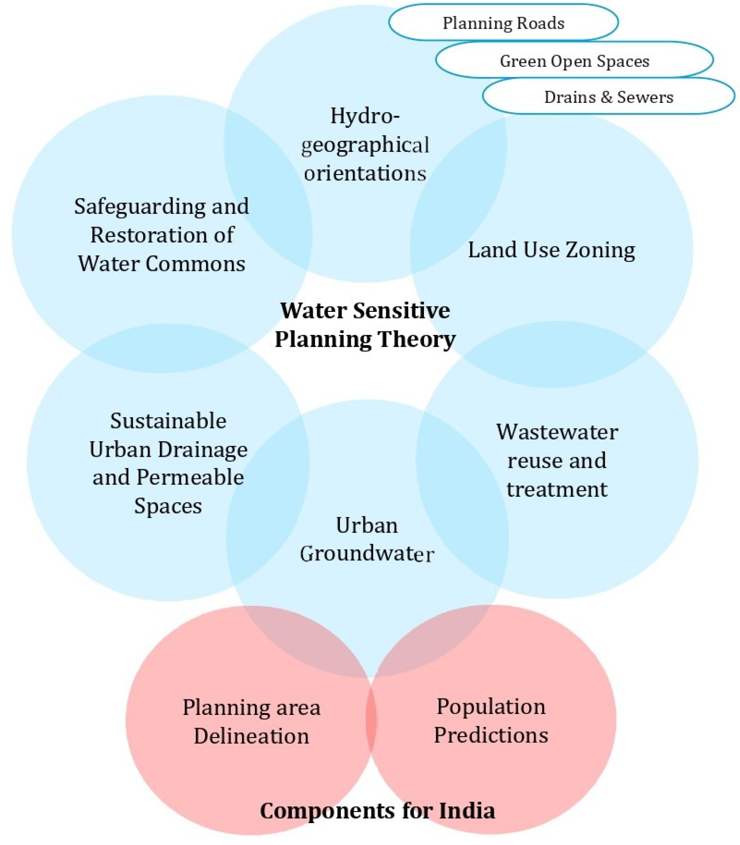
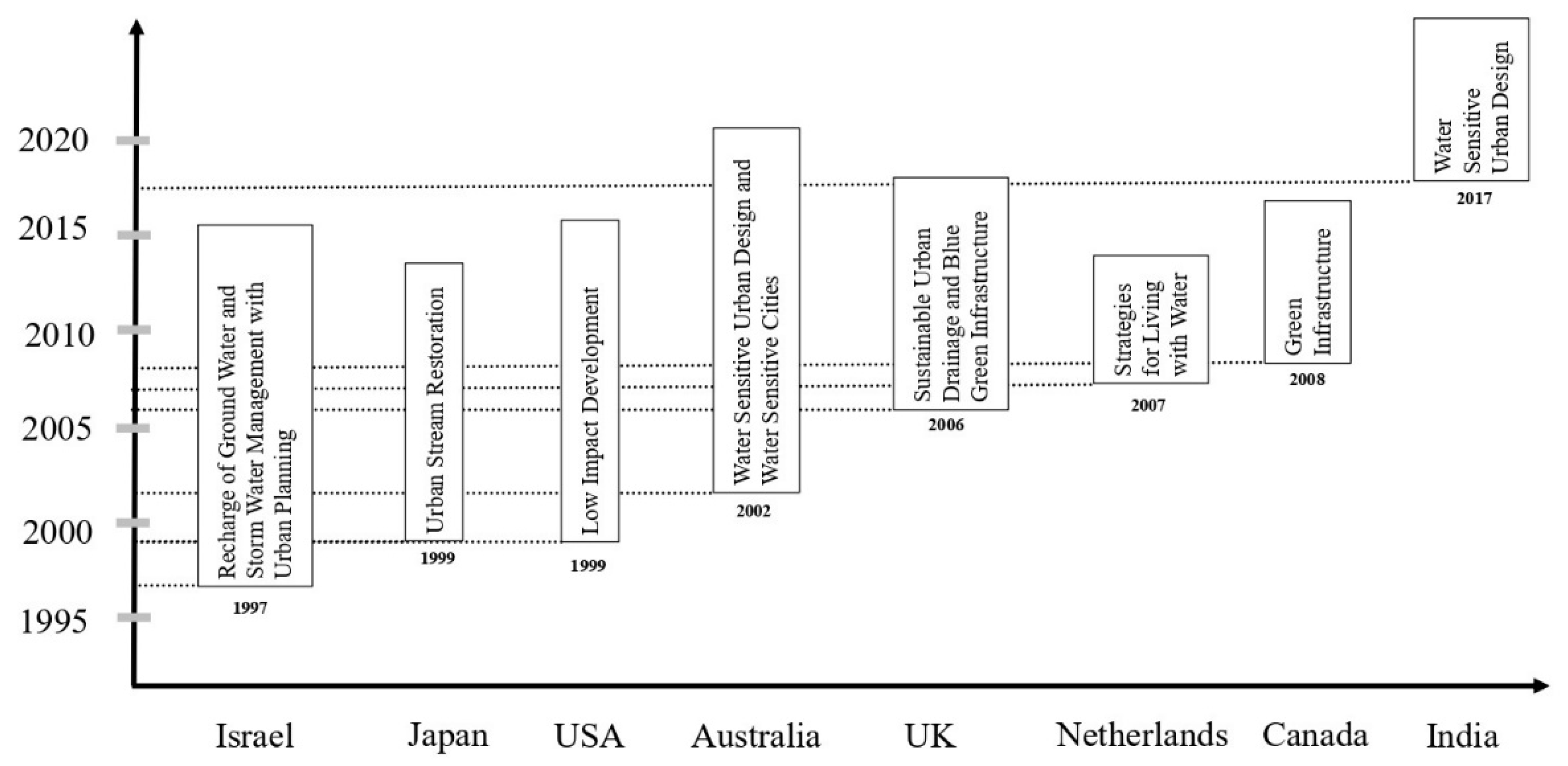
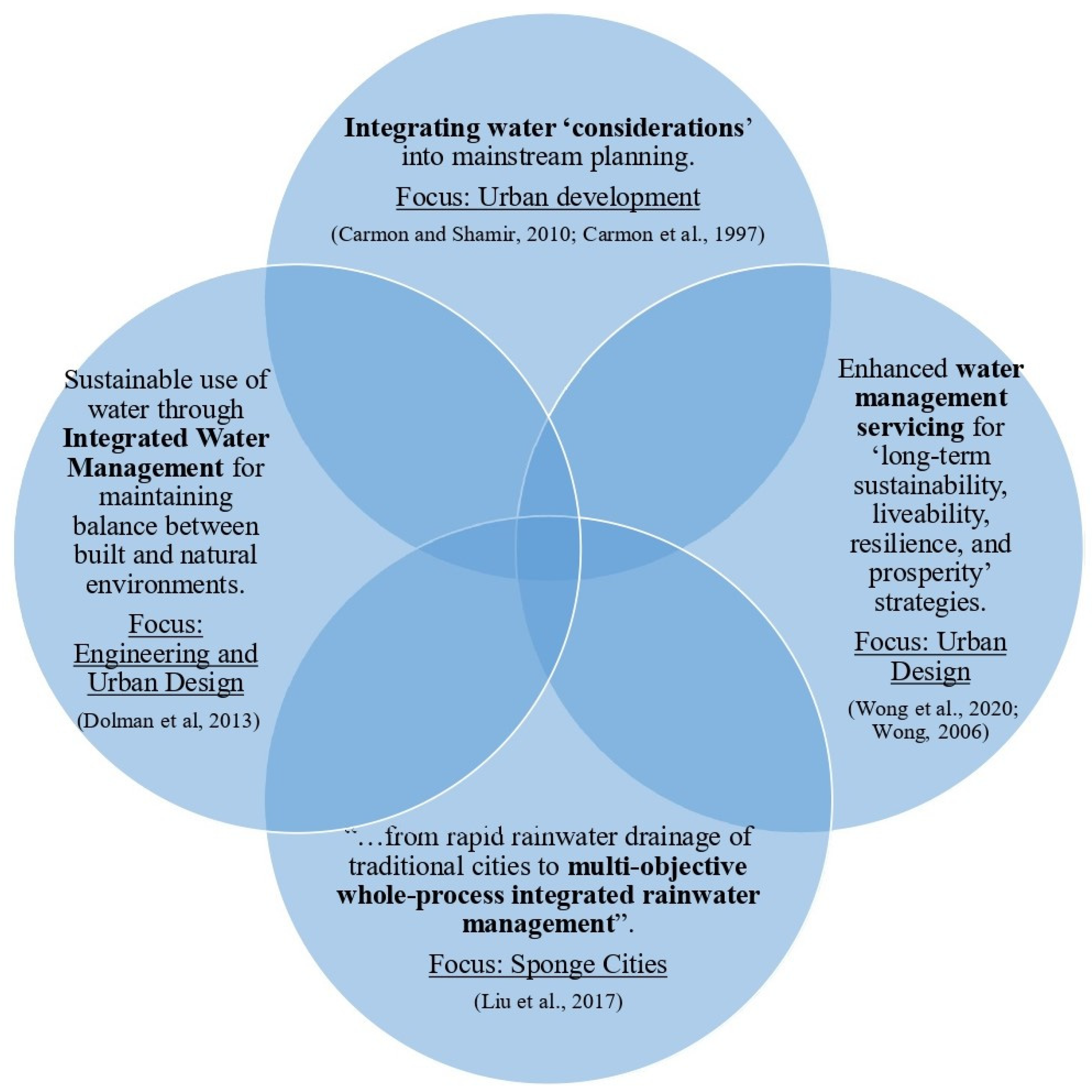
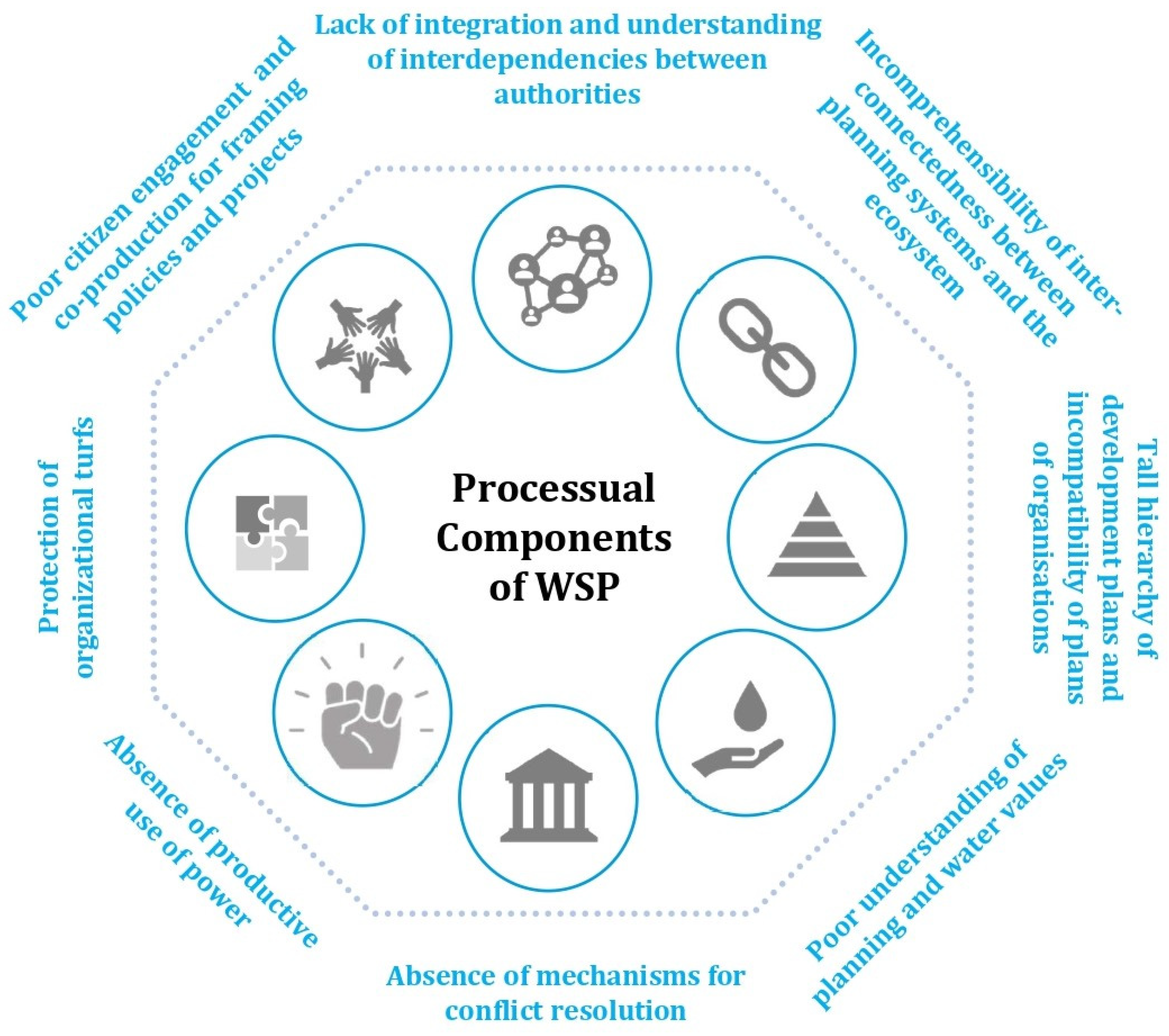
Table 1.
WSP: Critical differences between Cities of the Global North and South.
| S. No. | Parameters | Cities of the Global North | Cities of the Global South | Remarks for Cities of the Global South |
|---|---|---|---|---|
| 1. | Nature of Settlements | Largely Planned | Largely informally developed settlements | Provisioning of infrastructure |
| 2. | Infrastructure | Mostly available | Splintered, variegated, inequitable, and incremental | Integration of infrastructure |
| 3. | Financial Resources | Better equipped | Lacking financial resources to fill historical infrastructural gaps | Large investments in building new and replacing old infrastructure |
| 4. | Population Size | Relatively small | Mega (10 million and above) and meta cities (20 million and above) | Matching planning efforts to provide housing and infrastructure |
| 5. | Governance: Planning and implementation | Relatively effective | Mostly ineffective governance | Professional leadership with better financial rewards |
| 6. | Natural Resources | Better availability of water in relation to population | Scarcity of freshwater resources in comparison to population; More polluted water | Water insecurity may be more severely experienced by cities in the global south |
Disclaimer/Publisher’s Note: The statements, opinions and data contained in all publications are solely those of the individual author(s) and contributor(s) and not of MDPI and/or the editor(s). MDPI and/or the editor(s) disclaim responsibility for any injury to people or property resulting from any ideas, methods, instructions or products referred to in the content. |
© 2023 by the authors. Licensee MDPI, Basel, Switzerland. This article is an open access article distributed under the terms and conditions of the Creative Commons Attribution (CC BY) license (https://creativecommons.org/licenses/by/4.0/).
Share and Cite
MDPI and ACS Style
Kumar, A.; Button, C.; Gupta, S.; Amezaga, J. Water Sensitive Planning for the Cities in the Global South. Water 2023, 15, 235. https://doi.org/10.3390/w15020235
AMA Style
Kumar A, Button C, Gupta S, Amezaga J. Water Sensitive Planning for the Cities in the Global South. Water. 2023; 15(2):235. https://doi.org/10.3390/w15020235
Chicago/Turabian StyleKumar, Ashok, Cat Button, Shambhavi Gupta, and Jaime Amezaga. 2023. "Water Sensitive Planning for the Cities in the Global South" Water 15, no. 2: 235. https://doi.org/10.3390/w15020235
Note that from the first issue of 2016, this journal uses article numbers instead of page numbers. See further details here.