

Towards Quantifying the Coastal Vulnerability due to Natural Hazards using the InVEST Coastal Vulnerability Model

1
Department of Plant Sciences, College of Agricultural and Marine Sciences, Sultan Qaboos University, Muscat 123, Oman
2
Lazaridis School of Business and Economics, Wilfrid Laurier University, Waterloo, ON N2L 3C5, Canada
*
Author to whom correspondence should be addressed.
Water 2023, 15(3), 380; https://doi.org/10.3390/w15030380
Submission received: 26 September 2022
/
Revised: 11 January 2023
/
Accepted: 13 January 2023
/
Published: 17 January 2023
(This article belongs to the Special Issue Coastal Processes and Climate Change)
Abstract
:Coastal areas and coastal communities are facing threats due to the impacts of climate change. Therefore, assessing their vulnerabilities and the potential for natural habitats to contribute to protecting coastal areas and communities is essential for effective long-term planning, sustainability, and resilient coastal management. This study modeled and mapped coastal vulnerability using the InVEST 3.9.1 model developed by the Natural Capital Project Coastal Vulnerability model to explore the role of natural habitats in mitigating coastal hazards in Southern Al Sharqiya and Al Wusta Governorates of the Sultanate of Oman. The results showed that the highest hazard classification > 2.67 represented 18% of the coastal distribution, the intermediate hazard classification ranging between 2.31 and 2.66 represented 38% of the coastal distribution, and the lowest hazard classification ranging between 1.22 and 2.30) represented 44% of the coastal distribution. These results, however, did not account for the role of natural habitats in coastal protection. In terms of the role of natural habitats in mitigating coastal hazards, the presence of natural habitats reduced the extent of the highest exposed shoreline by 14% and 8% for the highest and intermediate areas, respectively. Under the natural habitat’s scenario, the habitats could provide 59% protection for the coastal communities under the highest exposure category and 41% under the intermediate category. Under a no-habitat scenario, about 75% of the coastal communities are exposed and vulnerable to coastal hazards under the highest hazard exposure category and 25% under the intermediate category. These results demonstrate that it is critical, especially for policymakers, to enhance the protection of coastal ecosystems to achieve coastal resilience. This study buttresses the importance of coastal ecosystem assessments in ensuring coastal resilience and climate change adaptation processes for any coastal countries.
1. Introduction
Humans have always had a relationship with the ocean and coastal areas. Humans have long depended on the ocean as a source of food. Most coastal areas are low-lying areas that are vulnerable to storm surges, tropical cyclones, and flooding. Storm surges and coastal flooding hazards are major risks to coastal areas throughout the world, and these risks are predicted to increase during the twenty-first century due to rising sea levels and expanding human development in coastal floodplains [1]. Sea level rise (SLR) is endangering people around the world, as 40% of the world’s population resides in coastal areas [2]. Coastal inundation and erosion due to SLR are increasing exposure to coastal hazards throughout Asia [3]. SLR, tsunamis, hurricanes, storm surges, and other types of flooding are causing the deaths of thousands of people and the destruction of hundreds of coastal communities’ socio-economic development [4]. Widespread human interference in coastal areas is often associated with various types of developments that contribute to changing the structures and functions of coastal ecosystems by altering the natural landscape and its life cycle [5]. Urban growth in coastal areas has increased the exposure risk for humans and their assets to current and future climate change hazards. Therefore, decision-makers need more than ever to be able to access information on current and future risks to develop management and planning strategies to mitigate risks. For instance, Mediterranean coastal administrations have been addressing the need to evaluate national and regional flood risks in Mediterranean coastal areas to develop a comprehensive plan that would help mitigate future and current risks to these areas [6].
It is clear that rapid urbanization and industrialization in coastal areas have had serious impacts on coastal ecosystems. Although coastal habitats and ecosystems have served humans in different ways, coastal pollution due to human practices has contributed to natural and ecosystem deterioration and destroyed habitats, thereby resulting in a noticeable decline in marine organisms and health [5]. In addition, climate change threatens coastal environments and ecosystems. Ecosystems showed vulnerability to climate change and human interference. The impact of both climate change and non-climatic drivers are anticipated to degrade and coral reefs and low-lying coastal wetlands [7]. For example, the effects of climate change and pollution have been observed along Taiwan’s ocean, where various mangroves and algal reefs have been negatively impacted [8].
About 60% of global ecosystem services have already been significantly degraded due to human actions, and this threat will continue in the future as climate change progresses [9]. For example, 58% of China’s coastal wetlands have been lost as a result of land reclamation due to urbanization and industrialization practices since the 1950s [10]. Consequently, coastal populations and infrastructure are at a higher risk of natural hazards, as the coastal ecosystems protection buffer is being lost due to exposure to the increasing frequency of storm surges, erosion, and inundation, and the need for an ecosystem-based management approach has become a necessity [11]. Mitigating the current and future climate change impacts, monitoring and modeling the impacts of human expansion and interference on ecological and social systems, as well as implementing sustainable development practices, are crucial [12].
Hence, one of the United Nations’ sustainable development goals (SDG 14) emphasizes the need to protect coastal ecosystems, their resources, and the people living in these areas by reducing marine pollution and practicing responsible green development and urbanization [13]. Therefore, assessing human influences on coastal ecosystems and detecting potential areas for ecosystem preservation and restoration are vital in ensuring the sustainability of ecosystem services, limiting biodiversity loss, and achieving overall ecosystem management [14]. For example, Wales recently addressed the importance of maintaining biodiversity to ensure the stability of ecosystem services, achieving a resilient society, protecting the economy for future generations, and adapting to climate change [15].
Therefore, emphasizing the role of natural habitats in mitigating coastal risks and hazards has become an important approach toward sustainability and resiliency. Some researchers have indicated that the importance of coastal habitats to coastal wetlands and fauna is undervalued, and their contributions to protecting coastal areas and their ecosystems should be understood, as 13% of marine megafauna are linked to seagrasses, mangroves, or saltmarsh habitats [16].
To prioritize the restoration of ecosystem services, it is important to identify areas with natural habitats that could contribute to mitigating coastal risk hazards and exposure to flooding, erosion, and inundation from SLR and storm surges. Information on where natural habitats help shield susceptible coastal communities and coastal areas from surges, SLR, and flooding could help in practicing informed decision-making. A case study conducted in Texas (an area facing an increase in major hurricanes and tropical storms, as 12 hurricanes have hit Texas in the last 100 years) showed the value of restoring coastal ecosystems as a nature-based solution to protecting coastal areas and communities [17]. Further, the Bahamas, the third richest country in the world with regards to natural habitats, has recognized the need to integrate nature-based solutions to protect their tourism industry, infrastructure development, and coastal communities from current and future climate change consequences [18]. However, in Asia, there is limited information about the role of natural habitats in protecting coastal areas [19]. For instance, in China, various researchers have indicated that policy development has not addressed the role of natural habitats in mitigating risks [17]. Current practices in Asia are based on vulnerability assessments and the identification of the potential role of nature in providing protection services for coastal communities and areas [20].
The objectives of this study are, first, to assess the vulnerabilities of current coastal areas and coastal communities to natural hazards using the InVEST Coastal Vulnerability model. The second goal is to explore the role of coastal natural habitats and their ability to shield coastal communities from natural hazards.
2. Materials and Methods
This study examined the risk to coastal communities for the Southern Al Sharqya and Al Wusta Governates in Oman. The hazard analysis considered the role of natural habitats in reducing the effects of flooding and erosion, and demographic information was used to identify vulnerable populations. In the sections that follow, the study areas and the InVEST Coastal Vulnerability model are introduced. Then, the data collection and model variables are introduced for the scenarios tested in this work. Finally, coastal communities’ vulnerabilities in relation to the hazard index and the benefits of natural habitats are discussed.
2.1. Study Area
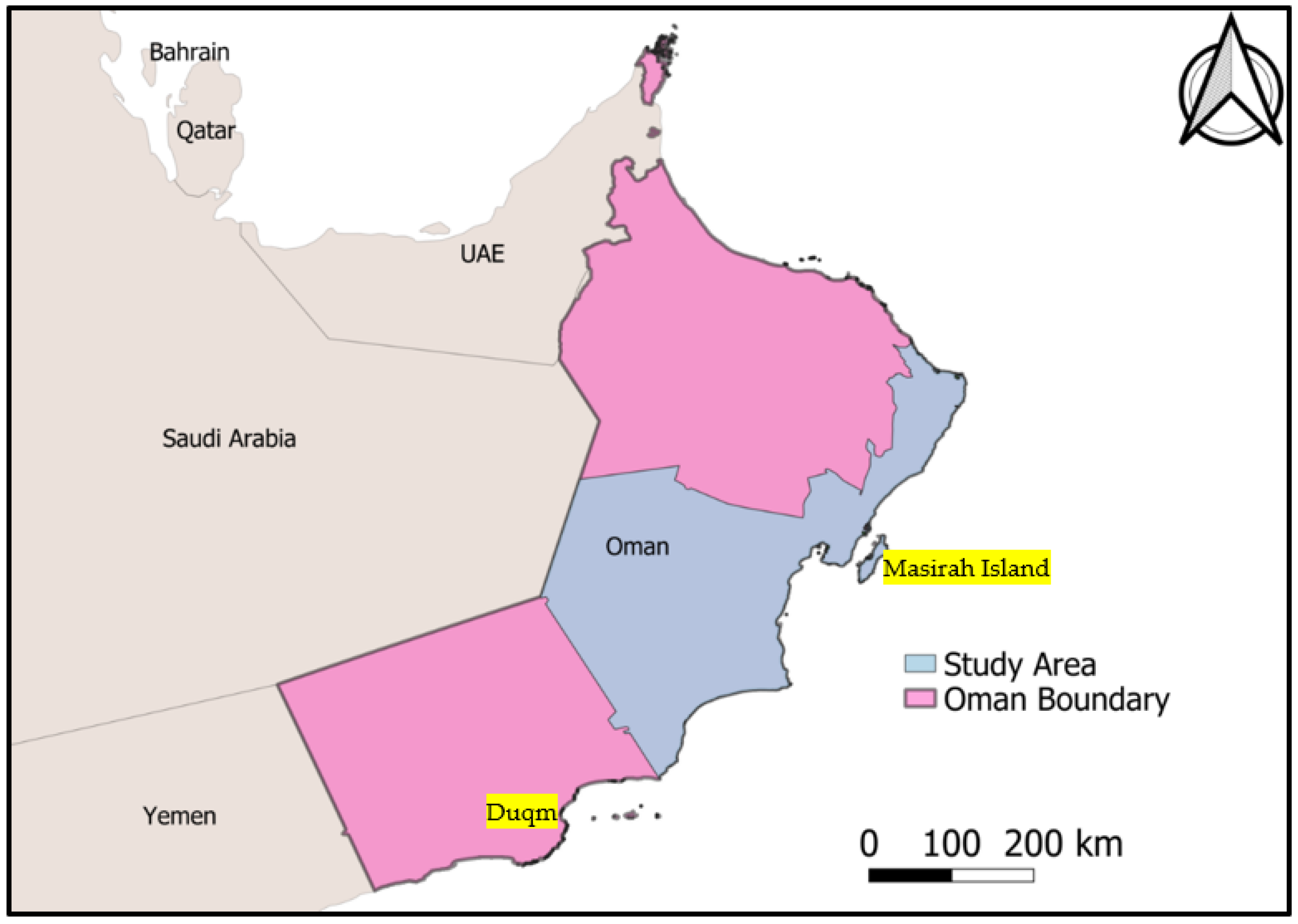
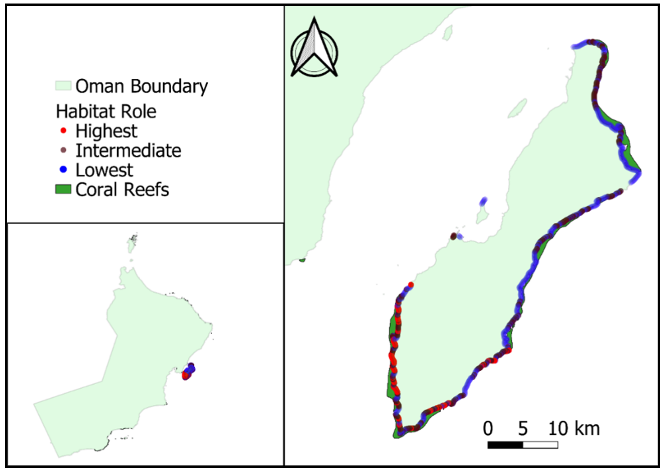
The Southern Al Sharqya and Al Wusta Governates are characterized by shallow coastal waters and a moderate continental shelf with a steep continental slope [21]. The area is known for its high fisheries productivity and biodiversity, as various ecosystems and natural habitats, such as mangroves, coral reefs, and seagrass, are found along its coastal area [22]. A map of this area is shown in Figure 1.
Natural reserves and natural habitats are planned to be used to contribute to the tourism sector in Oman. For example, Masirah Island is one of the areas proposed and developed for ecotourism. This is because the island features various environmental and marine resources, such as sandy beaches, areas suitable for water sports, more than 30,000 species of nesting female turtles, marine birds, and other forms of wildlife, as well as mangroves and coral reefs [23]. Duqm is another area seeing rapid industrial and social development that is enhancing industry, tourism, and marine transport mega-projects as alternative sources that are contributing to the national income other than oil [24]. Oman has invested heavily in the Duqm area as an approach to diversifying the country’s economic resources. The Duqm area is considered a special economic zone (SEZ) in Oman, and it is the largest Special Economic Zone (SEZ) in the Middle East and North Africa [25]. In addition, the Duqm area has been used for the development of wind energy due to its unique geographic location. The wind power density of Duqm ranges between 200 and 800 W/m2 at 80 m and is able to produce a total of about 75 GWh of net annual energy production, which can meet the area’s energy needs [26]. Moreover, the risk to this area is compounded by the fact that about 78% of its population is located in low-lying coastal zones and within 5 km of the coastal area.
2.2. Modeling Coastal Hazards
The InVEST Coastal Vulnerability model is used as a tool for assessing the risks associated with coastal hazards to people in the study area for the current condition. According to Sharp et al. [27], the InVEST Coastal Vulnerability model is an index-based tool used to evaluate the relative risk coastal hazards pose to coastal communities and to recognize habitats’ influences in providing coastal protection [27]. The model builds on indices that consider both biophysical and climatic variables that affect flooding and inundation exposure from coastal hazards [28] by explicitly considering the role of ecosystems in providing coastal protection and incorporating information about people, property, and other relevant metrics in the framing of risk.
This study evaluated coastal hazard risk to coastal communities at a 250-m2 spatial resolution along the coast of the Southern Al Sharqya and Al Wusta governates for current SLR and habitat scenarios. The InVEST Coastal Vulnerability model was used to calculate the hazard index, which ranked the relative exposure of the shoreline to flooding and erosion based on the following variables: habitat type and extent, coastal elevation, wave exposure, shoreline type, and SLR. Each variable of each 250-m coastal segment was ranked from lowest exposure (rank = 1) to highest exposure (rank = 5) by combining the absolute and relative ranks of the modeled and observed data, as shown in Table 1. The geometric mean of the ranked variables was computed to obtain the final coastal hazard index (where R = rank, formula below). The relative exposure to flood and erosion hazards for each 250-m coastal segment area was compared with all other segments across the study area for SLR and habitat scenarios. The multiplicative model for the exposure index is used instead of an additive model, as the coastal processes and interactions among the components of coastal ecosystems are non-linear [18].
To express the relative coastal hazard exposure, the study categorized the values of all variables from 1 to 5 to map the hazards. The categorization of the hazard index was based on Silver et al. [18] study, following these categories: the areas with the highest hazard, >2.667 of the distribution; intermediate hazard, 2.316–2.667 of the distribution; and lowest hazard, <2.316 of the distribution. In addition, the study also examined the coastal hazard index for the coastal communities to estimate the vulnerable populations and the risk of coastal hazards to the coastal communities in the study area.
2.3. Data Input for Hazard Modeling
This study used various input data collected from globally available datasets that included coastal habitats, relief, wave exposure, digital elevation models, shoreline types, and surge potential (Appendix A).
Many researchers have identified the advantage of habitats in providing protection from erosion and flooding by decreasing wave energy, weakening storm surges, or trapping sediments [29]. According to Sharp et al. [27], protective distance for different types of habitats contributes to protecting the shoreline and mitigating coastal vulnerability to hazardous risks, such as coral reefs [29]. Information on the global distribution of coral reefs was obtained from UNEP-WCMC 2021 [30], the Atlas of Mangroves was sourced for information on mangroves of the world [31], and information on seagrass (Green EP & Short FT 2003) [32] was taken from global seagrass species richness datasets. All of the obtained habitat data were projected using linear units in meters (WGS 1984 UTM Zone 40N projection). Updates for older datasets were obtained from local resources. The model can be reapplied as up-to-date data become available.
2.4. Habitat Scenarios
This study analyzed and quantified the role of natural habitats in reducing risk to coastal communities. Two scenarios were considered (with habitat and no habitat) to quantify the role of habitats in protecting coastal areas. The no-habitat scenario was used to assess the extent of protection provided by the habitats to coastal communities.
2.5. Quantifying Risk to Coastal Communities
The demographic variables for cities are mapped to show the total population per square kilometer [33]. To evaluate the vulnerability of coastal communities to coastal hazards, the overlap between the coastal segments with the highest exposure to coastal hazards was evaluated. The total number of people living in coastal cities for each shoreline segment was estimated based on the coastal hazard index.
3. Results and Discussion
This section presents the key findings of the model output for the study area. This section also covers the drivers of risk and their spatial distribution, as well as the habitat contribution in mitigating coastal hazards. The discussion section provided insight into how the model output could be used to improve decision-making processes in the study area.
3.1. Distribution and Drivers of Coastal Hazards
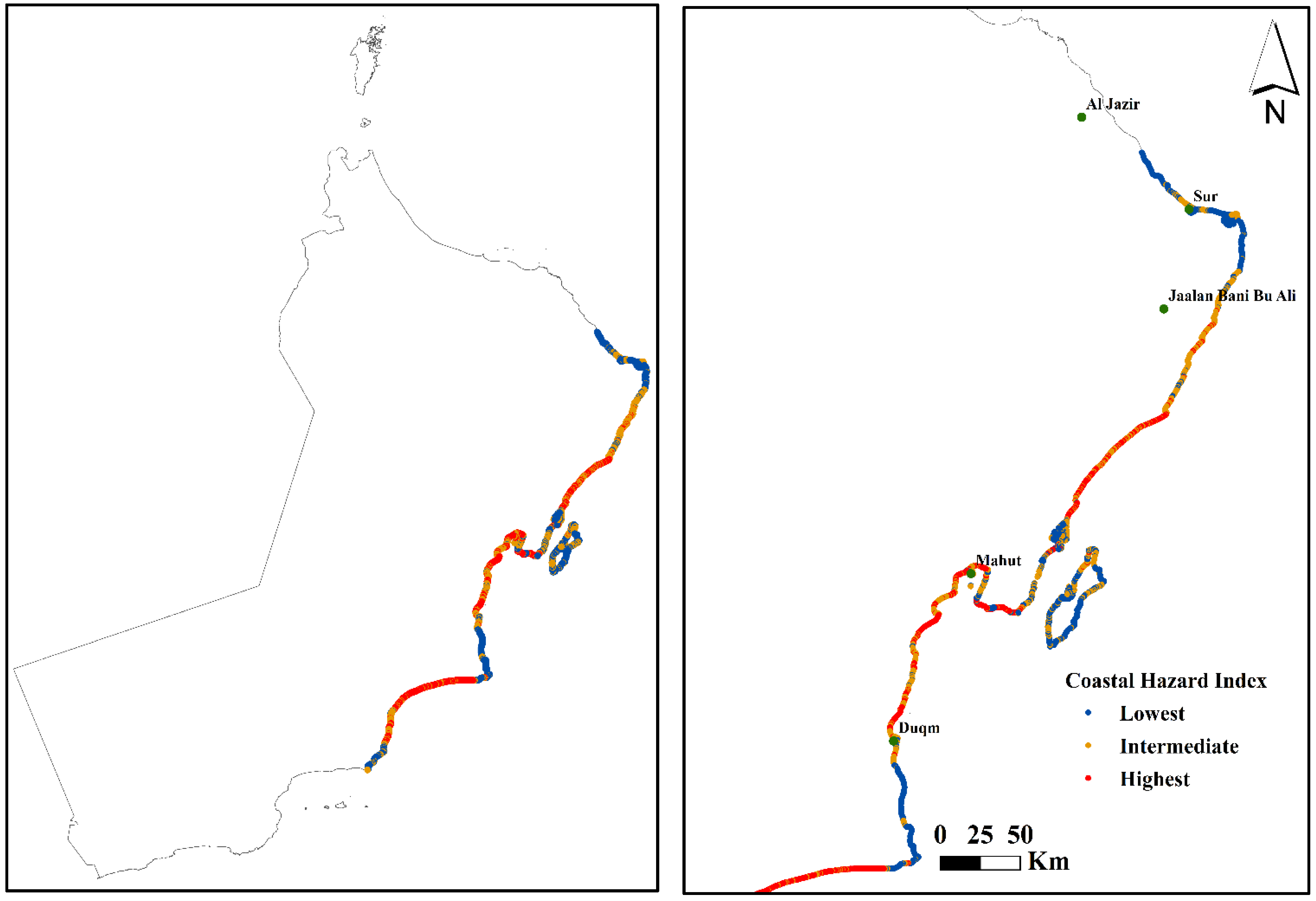
The results show that Sur, Jaalan Bani Bu Ali, Mahut, Duqm, and Al Jazir are the most exposed coastlines in the study area, particularly along low-lying areas with sandy beaches and no natural habitat abundance, as shown in Figure 2.
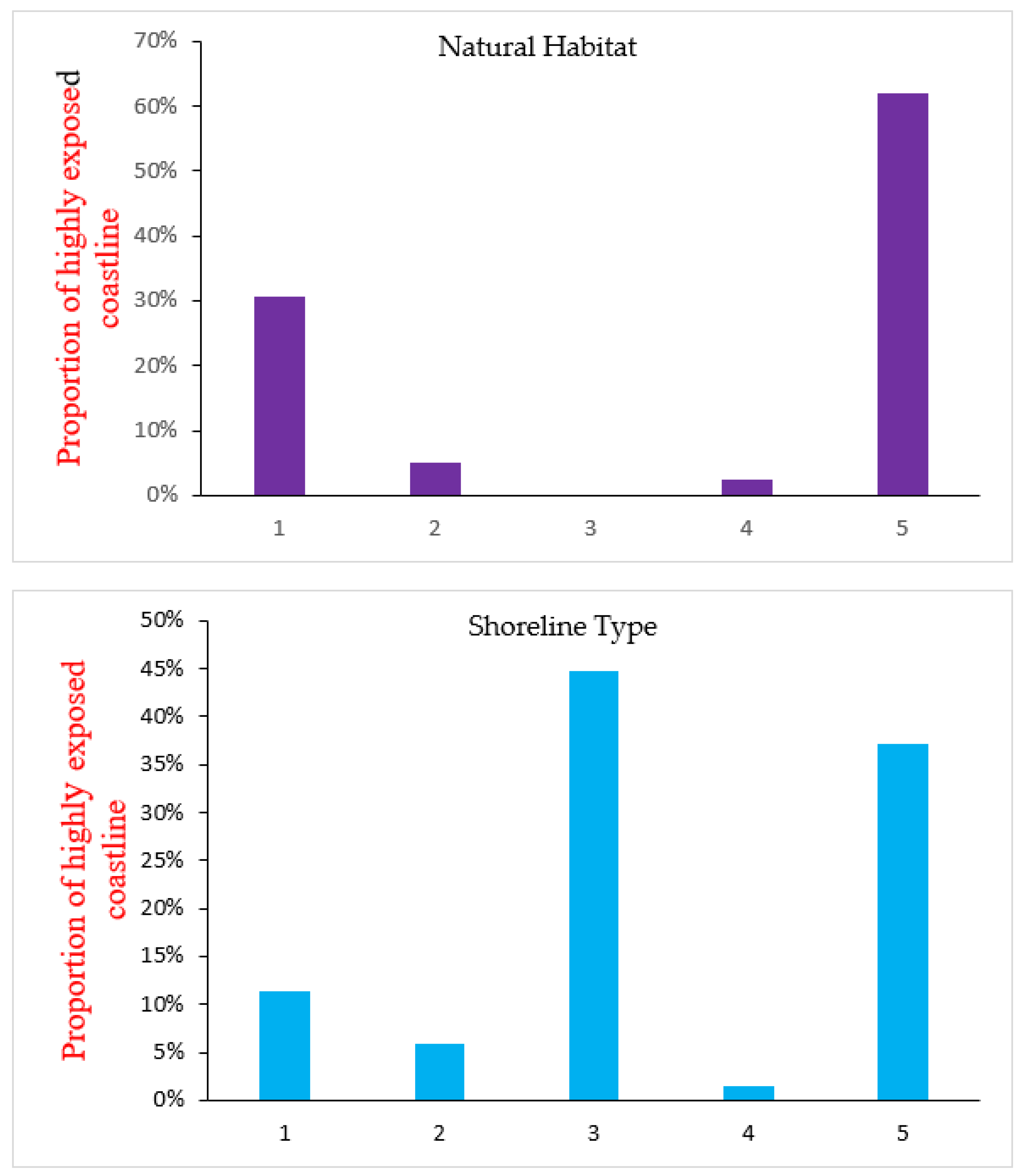
The model output shows that surge potential, relief, and wave exposure were distributed uniformly by 20% at each rank from 1 to 5 across the study area, indicating that these variables may be less significant in influencing differences in coastal exposure. This result is in agreement with the findings reported by Silver et al. [18], who found a similar pattern in the contribution of these variables to the coastal hazard index. However, erodible sediments and habitat availability are key factors driving risk along the study area with large proportions of exposed shorelines. The shoreline type and natural habitat variables showed a higher rank, indicating that these are essential variables in driving the relatively high exposure of the study area as shown in Figure 3.
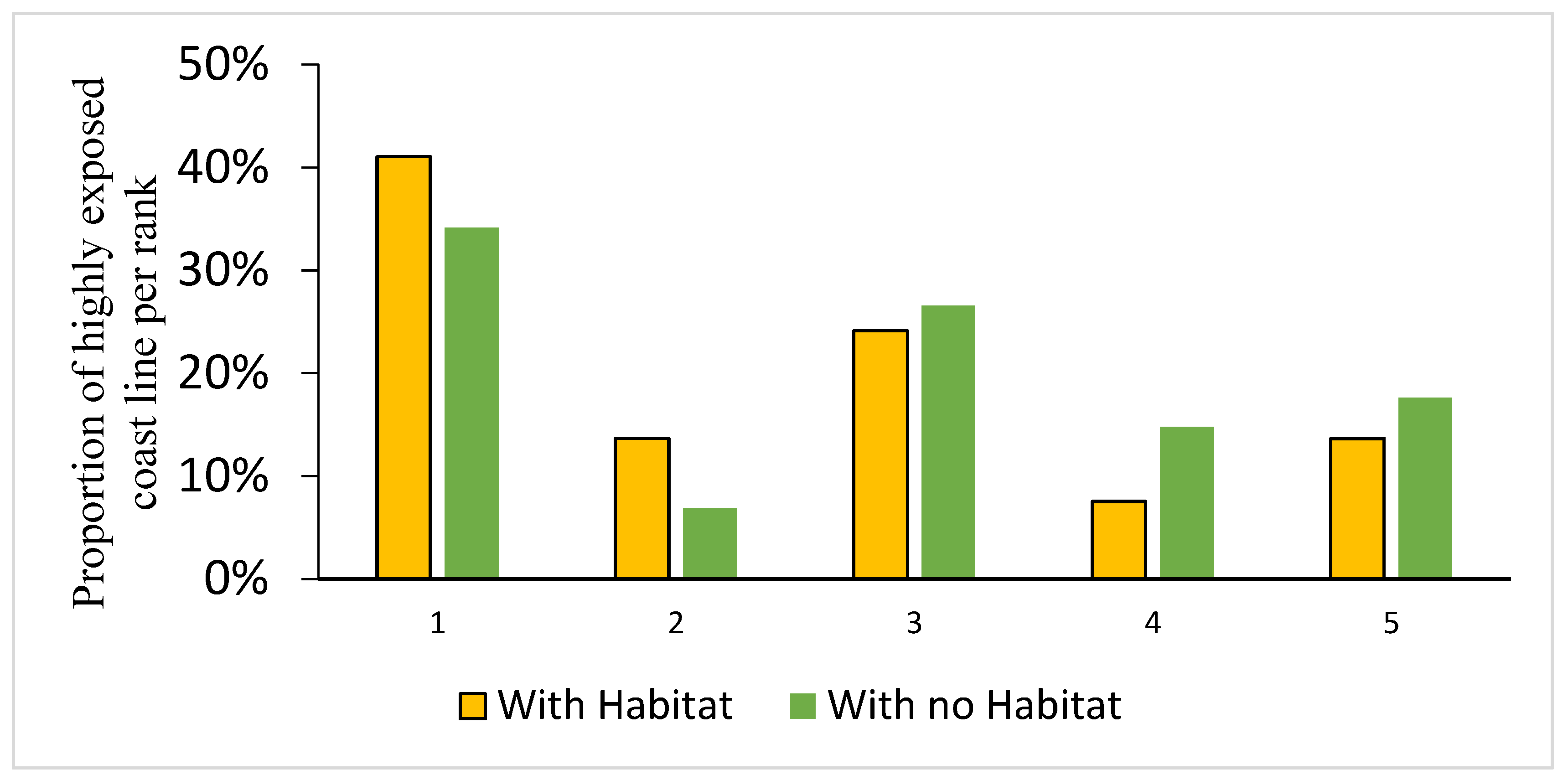
The model output shows that coastal ecosystems and habitats are key to reducing exposure to coastal hazards, as these ecosystems could provide coastal protection for the study area by maintaining low exposure to the coastal area. For example, 7% of the study coastal areas showed the highest exposure to coastal hazards without natural habitats, and 37% were at intermediate risk. In the case of natural habitat availability along the study coastal area, habitats have the potential to preserve 38% of the study coastal area. Therefore, protecting natural habitats and encouraging their establishment could help mitigate natural hazards in the coastal region of the study area.
In terms of the natural habitat’s role in mitigating SLR, the analysis shows the potential of ecosystems to contribute to mitigating exposure to coastal hazards as a consequence of SLR under current conditions across the study area. The presence of coastal habitats can reduce the extent of the highest exposed shoreline by 14% for areas ranked as 5 and 8% for those ranked as 4, while the coastal exposure for SLR under current conditions without habitat contribution could result in 15% and 18% for areas ranked as 4 and 5, respectively, as shown in Figure 4. For example, Figure 5 shows a map of Masirah’s Island and the contribution of natural habitats to coastal protection. The area in red shows the highest contribution of habitat in protecting the coastal area, representing 9% of the coastal area, while the area in blue shows the lowest contribution of natural habitat in providing coastal protection, as it represents 65% of the coastal area. The vulnerability and risk of coastal hazards increase when there is no or less habitat contribution toward coastal protection. The study area has a large proportion of the highest-risk shoreline; thus, the high risk of the study area shoreline increases significantly with habitat loss, as shown in Figure 2.
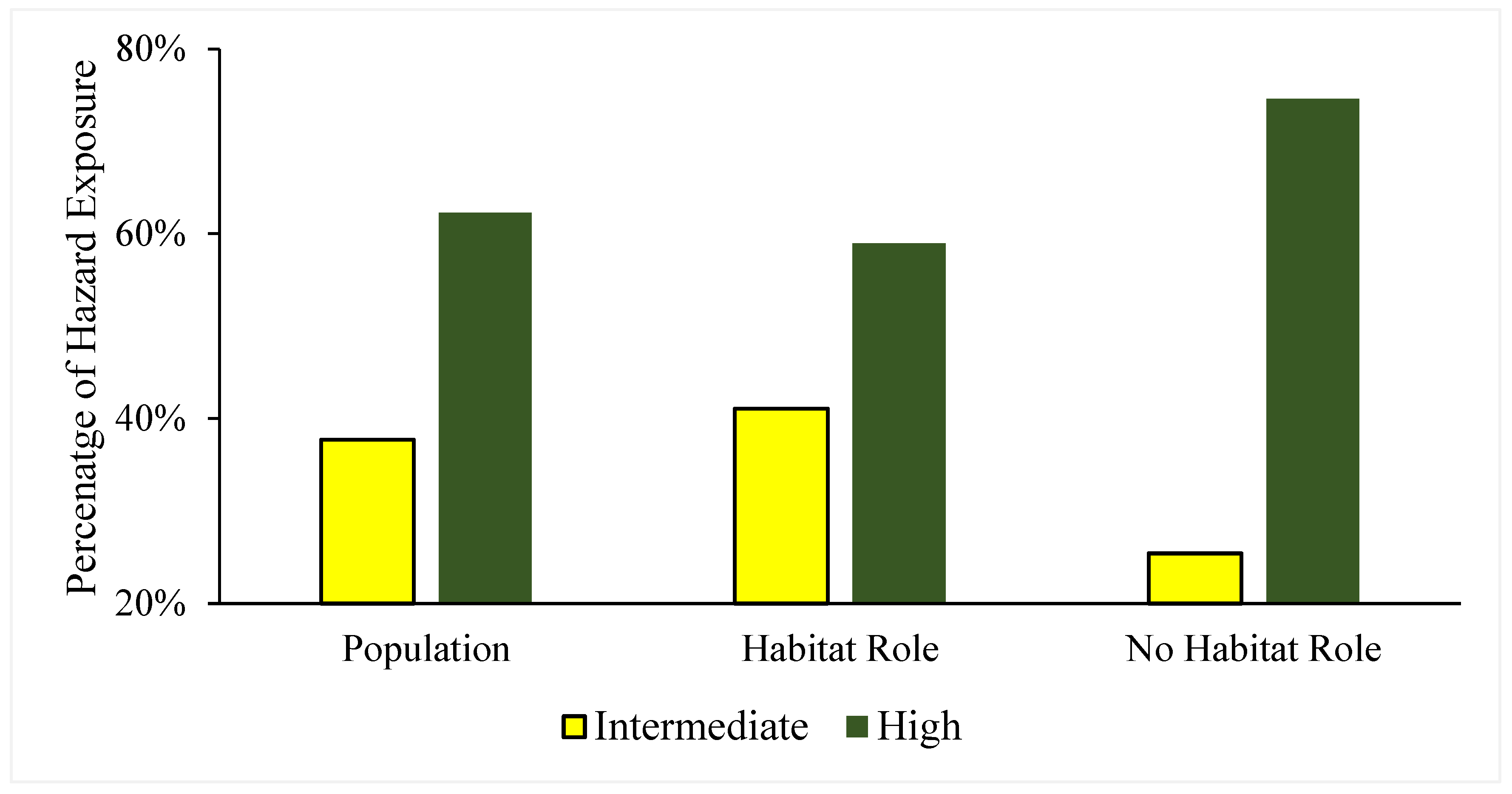
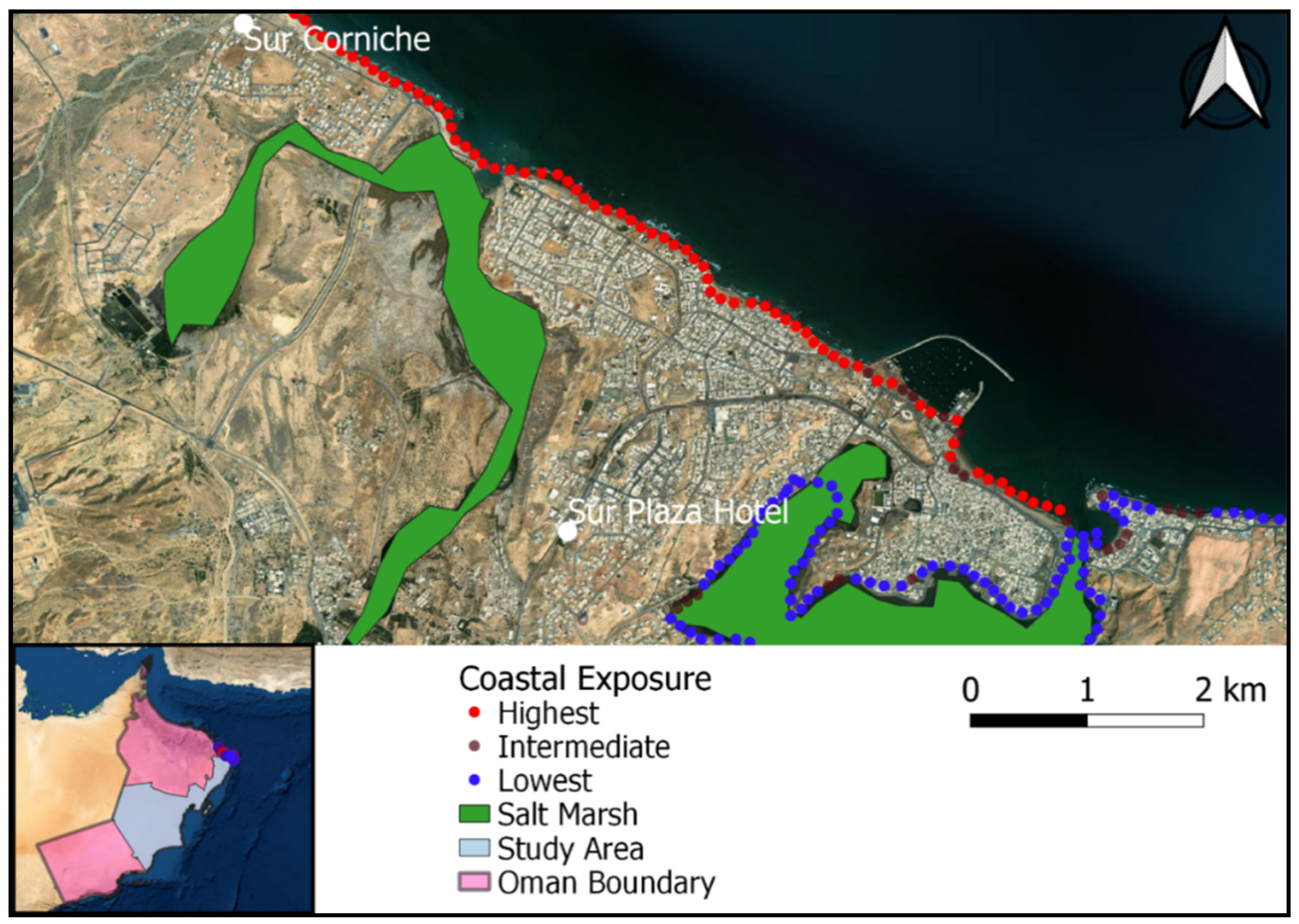
The model output indicates that the coastal habitat could provide protection for the coastal communities along the coastal area of the study site. About 62% of the study area’s population is exposed to high hazard risk. The habitats could provide 59% protection for the coastal communities under the highest exposure category and 41% under the intermediate category. Under the no-habitat scenario, about 75% of the coastal communities would be exposed and vulnerable to coastal hazards under the highest hazard exposure category and 25% under the intermediate category. The results of this study suggest that coastal communities will benefit from the coastal protection provided by ecosystems and natural habitats, as shown in Figure 6. For instance, Figure 7 shows a spatial map of Sur City, which is one of the most populated areas in the study area. Due to the lack of natural habitats along its coastal area, many coastal communities are exposed to coastal hazards, representing 21% and 30% of the highest and intermediate categories, respectively.
3.2. Comparison with Other Global Studies and Future Perspectives
Most of the literature has examined the role of gray infrastructure and biophysical factors in mitigating coastal risk to ecosystems, and little attention has been given to the benefits of coastal societies [17]. The output of this study integrated climate scenarios, demographic information, and ecological data to explore the hazard risk, thus assessing both the contribution of physical and ecological factors in enabling ecosystems to reduce coastal hazard effects. Therefore, we provide insights into where people stand to benefit the most through the protection afforded by available natural habitats.
Many recent researchers have emphasized the value of coastal and marine ecosystems due to their contribution to enhancing ecosystem goods and services [34]. Adapting and using coastal ecosystems to reduce the risk to socially vulnerable communities has received little attention from researchers. However, concepts such as resilience through the integration of natural habitats are used as tools for climate change adaptation in coastal areas by creating socioecological systems capable of absorbing and recovering from disturbances [35]. This approach could serve as an alternative to the use of traditional gray infrastructure, such as sea walls, to mitigate the impact of climate change. With the current risk of SLR and the increased populations along coastal areas, these coastal developments are jeopardizing coastal ecosystems, and increased attention to the nature-based protection approach is needed to promote sustainability and provide an alternative tool for decision-makers to ensure safe and accessible coastal communities. This study suggests that natural habitats have the potential to reduce the risk magnitude for coastal communities under SLR, and they are anticipated to contribute more under future SLR scenarios.
Previous studies have demonstrated the benefits of coastal ecosystems in minimizing risk [36,37]. The present study showed the potential of coastal habitats to reduce coastal hazards to coastal communities. For example, the Japanese have long practiced the concept of using coastal ecosystems to protect people, such as by using “ring dikes” [17]. Even though the magnitude of habitat protection is dependent on morphological characteristics, distribution, and habitat conditions, habitats’ utilization emphasizes the need for natural solutions and innovations to mitigate climate change’s impacts [38]. Around the world, low-lying areas are the places most exposed to erosion [39]. Therefore, the establishment of natural habitats can play a major role in conserving these areas under current and future sea-level rise scenarios. This study provides knowledge about the ecosystem’s role in achieving coastal resilience, as it facilitates an understanding of the value of nature-based solutions in overcoming future climate change scenarios.
Since Cyclone Gonu of 2007, which caused hundreds of millions of dollars in damage across the country, it has clearly become very important to inform decision-makers to explore and understand how ecosystems and natural habitats can help reduce coastal risk and increase the resiliency of coastal communities (Phet, 2010; Shaheen, 2021). Spatial planning and integrated management approaches could also be used to help inform critical infrastructure development to minimize the future damage potential from such events [40]. As a result, comprehensive science-based policies and plans should be developed to reduce risks.
The InVEST Coastal Vulnerability model serves as an effective tool for quickly testing climate scenarios to inform decision-makers [17]. However, the model has some limitations. For instance, the use of a surge potential proxy that may generalize storm dynamics could result in the underestimation or overestimation of exposure and vulnerability risks for some coastal areas. The habitat information and ranks were based on the literature review, which may have missed some information about its mechanisms and empirical validation [6,18]. The study also lacked information about future SLR, as global data for the study area were limited. According to Arkema et al. [17], other factors also have the potential to influence coastal hazards, such as the intensity and frequency of storms, ocean acidification effects, and the effects of high temperatures on coal, which were not captured in the current model. With regard to coastal communities’ vulnerabilities, further analysis could be carried out to improve the study findings, including the age and gender of the population.
However, many studies have used empirical data to evaluate coastal vulnerability and coastal hazard risks [41]. In the US, empirical flood data were used to assess flood vulnerability and identify the populations most at risk of flood hazards [42]. Montalto di Castro, Italy, used empirical data and data available on national and local scales to assess the vulnerability and coastal hazards of the area [43]. This indicates that the Coastal Vulnerability model can be applied even in data-scarce areas to help decision-makers explore what nature-based solutions may be possible to use to reduce risks and provide coastal protection.
4. Conclusions
This study demonstrated the usefulness of the InVEST Coastal Vulnerability model for producing a spatial assessment of the coastal hazard risk in a coastal country. The model is also capable of detecting where coastal habitats could play a protective role for vulnerable coastal communities under current and future SLR. Natural and coastal habitats in Oman play a significant role in protecting coastal communities and coastal areas from coastal hazards, and they will become more important as climate change progresses and its consequences become more intense. This modeling approach and assessment could be valuable for other countries, especially those with scarce data. The findings of this study could be useful in helping Oman and other coastal areas create a framework for reducing disaster risk and the loss of lives, as well as infrastructure at the national and global scales. The findings highlight the application of one of the United Nations’ sustainable development goals—i.e., the integration of ecosystems as mitigation tools for adapting to climate change consequences and achieving coastal resilience. Therefore, the establishment of a blue carbon strategy is attracting global efforts to integrate ocean-based natural climate solutions as an additional way of mitigating the consequences of climate change. Finding natural and green strategies to face climate change through applying sustainable development goals is vital to avoiding negative impacts and delivering better outcomes for future generations. In addition to the valuable benefits of these natural habitats for ecosystem function, biodiversity, and coastal communities, they could also serve as mitigation tools in providing carbon credits due to their ability to store carbon in achieving national-level climate mitigation goals.
Author Contributions
Conceptualization, A.A.R.; methodology, A.A.R.; software, A.A.R.; validation, A.A.R.; formal analysis A.A.R.; investigation, A.A.R.; resources, A.A.R.; data curation, A.A.R.; writing—original draft preparation, A.A.R.; writing—review and editing, A.A.R. & A.B.; visualization, A.A.R. & A.B.; supervision, A.A.R.; project administration, A.A.R. All authors have read and agreed to the published version of the manuscript.
Funding
This research received no external funding.
Data Availability Statement
Data will be made available on reasonable request.
Acknowledgments
The authors would like to thank the three anonymous reviewers for their constructive suggestions.
Conflicts of Interest
The authors declare no conflict of interest.
Appendix A

Table A1.
Coastal vulnerability model data inputs and sources.
| Model Input | Year | Extent | Resolution | Source | |
|---|---|---|---|---|---|
| Natural habitats | Coral Reef | 2009 | Global | 30 m | UNEP World Conservation Monitoring Centre (UNEP-WCMC). |
| Seagrass | UN Environment Program World Conservation Monitoring Centre. | ||||
| Mangrove | 2003 | The UN Environment Program World Conservation Monitoring Centre (UNEP-WCMC) | |||
| Saltmarsh | 2015 | The UN Environment Program World Conservation Monitoring Centre (UNEP-WCMC) | |||
| Relief | Digital elevation model (30 m) | 2014 | Global | 30 m | Shuttle Radar Topography Mission |
| Wave exposure | 2005–2010 | Global | 50 km | National Oceanographic and Atmospheric Administration WaveWatch III | |
| Shoreline type | Coastal geomorphology | 2020 | Oman | Vector | National Static and Information Center |
| Surge potential | Continental shelf | 2005 | Global | Vector | Continental Margins Ecosystem (COMARGE) effort in conjunction with the Census of Marine Life |
| Sea level rise | SLR | 2020 | Global | Vector | https://www.aviso.altimetry.fr/ (6 December 2021) |
References
- Tiggeloven, T.; De Moel, H.; Winsemius, H.C.; Eilander, D.; Erkens, G.; Gebremedhin, E.; Ward, P.J. Global-scale benefit–cost analysis of coastal flood adaptation to different flood risk drivers using structural measures. Nat. Hazards Earth Syst. Sci. 2020, 20, 1025–1044. [Google Scholar] [CrossRef] [Green Version]
- Seas, U.R.; Plans, A. Percentage of Total Population Living in Coastal Areas. 2011. Available online: https://saimi.co.za/ (accessed on 6 December 2021).
- World Bank. Vulnerability, Risk Reduction and Adaptation to Climate Change: Ghana; The World Bank: Washington, DC, USA, 2011; Available online: http://sdwebx.worldbank.org/climateportalb/doc/GFDRRCountryProfiles/wb_gfdrr_climate_change_country_profile_for_GHA.pdf (accessed on 12 December 2021).
- Dube, K.; Nhamo, G.; Chikodzi, D. Flooding trends and their impacts on coastal communities of Western Cape Province, South Africa. GeoJournal 2022, 87, 453–468. [Google Scholar] [CrossRef] [PubMed]
- Zhai, T.; Wang, J.; Fang, Y.; Qin, Y.; Huang, L.; Chen, Y. Assessing ecological risks caused by human activities in rapid urbanization coastal areas: Towards an integrated approach to determining key areas of terrestrial-oceanic ecosystems preservation and restoration. Sci. Total Environ. 2020, 708, 135153. [Google Scholar] [CrossRef] [PubMed]
- Wolff, C.; Vafeidis, A.T.; Lincke, D.; Marasmi, C.; Hinkel, J. Effects of Scale and Input Data on Assessing the Future Impacts of Coastal Flooding. Front. Mar. Sci. 2016, 3. [Google Scholar] [CrossRef] [Green Version]
- IPCC. Summary for Policymakers. In Climate Change 2022: Impacts, Adaptation and Vulnerability. Contribution of Working Group II to the Sixth Assessment Report of the Intergovernmental Panel on Climate Change; Pörtner, H.-O., Roberts, D., Poloczanska, E., Mintenbeck, K., Tignor, M., Alegría, A., Craig, M., Langsdorf, S., Löschke, S., Möller, V., et al., Eds.; Cambridge University Press: Cambridge, UK; New York, NY, USA, 2022; pp. 3–33. [Google Scholar] [CrossRef]
- Chiang, Y.C.; Chang, H.P. Cultural dimensions of risk perceptions: A case study on cross-strait driftage pollution in a coastal area of Taiwan. J. Environ. Manag. 2018, 206, 123–133. [Google Scholar] [CrossRef] [PubMed]
- Pereira, H.M.; Leadley, P.W.; Proença, V.; Alkemade, R.; Scharlemann, J.P.; Fernandez-Manjarrés, J.F.; Walpole, M. Scenarios for global biodiversity in the 21st century. Science 2010, 330, 1496–1501. [Google Scholar] [CrossRef] [Green Version]
- Liu, L.; Wang, H.J.; Yue, Q. China’s coastal wetlands: Ecological challenges, restoration, and management suggestions. Reg. Stud. Mar. Sci. 2020, 37, 101337. [Google Scholar] [CrossRef]
- O’Higgins, T.; Nogueira, A.A.; Lillebø, A.I. A simple spatial typology for assessment of complex coastal ecosystem services across multiple scales. Sci. Total Environ. 2019, 649, 1452–1466. [Google Scholar] [CrossRef]
- Yang, H.; Huang, J.; Liu, D. Linking climate change and socioeconomic development to urban land use simulation: Analysis of their concurrent effects on carbon storage. Appl. Geogr. 2020, 115, 102135. [Google Scholar] [CrossRef]
- United Nations (UN). Transforming Our World: The 2030 Agenda for Sustainable Development. In Resolution Adopted by the General Assembly on 25 September 2015. Seventieth Session, Agenda Items 15 and 116. A/RES/70/1. 2015. Available online: http://www.un.org/ga/search/view_doc.asp?symbol=A/RES/70/1&Lang=E (accessed on 15 December 2021).
- Isbell, F.; Craven, D.; Connolly, J.; Loreau, M.; Schmid, B.; Beierkuhnlein, C.; Eisenhauer, N. Biodiversity increases the resistance of ecosystem productivity to climate extremes. Nature 2015, 526, 574–577. [Google Scholar] [CrossRef]
- Sanderson Bellamy, A.; Galliford, H.J. Biodiversity and the Area-Based Approach in Wales: How Can the Sustainable Management of Natural Resources (SMNR) Framework Deliver Nature Recovery? Summary and Key Findings; Cardiff University: Cardiff, UK, 2018. [Google Scholar]
- Sievers, M.; Brown, C.J.; Tulloch, V.J.; Pearson, R.M.; Haig, J.A.; Turschwell, M.P.; Connolly, R.M. The role of vegetated coastal wetlands for marine megafauna conservation. Trends Ecol. Evol. 2019, 34, 807–817. [Google Scholar] [CrossRef] [PubMed]
- Arkema, K.K.; Griffin, R.; Maldonado, S.; Silver, J.; Suckale, J.; Guerry, A.D. Linking social, ecological, and physical science to advance natural and nature-based protection for coastal communities. Ann. N. Y. Acad. Sci. 2017, 1399, 5–26. [Google Scholar] [CrossRef] [PubMed]
- Silver, J.M.; Arkema, K.K.; Griffin, R.M.; Lashley, B.; Lemay, M.; Maldonado, S.; Verutes, G. Advancing coastal risk reduction science and implementation by accounting for climate, ecosystems, and people. Front. Mar. Sci. 2019, 6, 556. [Google Scholar] [CrossRef] [Green Version]
- Kropp, J.P.; Boettle, M.; Rybski, D. Quantifying the effect of sea level rise and flood defence–A point process perspective on coastal flood damage. Nat. Hazards Earth Syst. Sci. 2016, 16, 559–576. [Google Scholar] [CrossRef] [Green Version]
- Sajjad, M.; Li, Y.; Tang, Z.; Cao, L.; Liu, X. Assessing hazard vulnerability, habitat conservation, and restoration for the enhancement of mainland China’s coastal resilience. Earth’s Future 2018, 6, 326–338. [Google Scholar] [CrossRef] [Green Version]
- Smith, C.R.; Levin, L.A.; Hoover, D.J.; McMurtry, G.; Gage, J.D. Variations in bioturbation across the oxygen minimum zone in the northwest Arabian Sea. Deep. Sea Res. Part II Top. Stud. Oceanogr. 2000, 47, 227–257. [Google Scholar] [CrossRef]
- Khvorov, S.A.; Al-Sinawi, M.N.; Al-Kharusi, L.H.; Mohammad, N. Catalogue of brachyuran crabs (Decapoda) of the Sultanate of Oman: Part I. The Arabian Sea coast (Dhofar, Al-Wusta, southern part of Sharqiya). Crustaceana 2012, 85, 1735–1744. [Google Scholar] [CrossRef] [Green Version]
- Mansour, S.; Al-Awhadi, T.; Al-Hatrushi, S. Geospatial based multi-criteria analysis for ecotourism land suitability using GIS & AHP: A case study of Masirah Island, Oman. J. Ecotourism 2020, 19, 148–167. [Google Scholar] [CrossRef]
- Deif, A.; Mohamed, A.M.; El-Hussain, I.; Al-Shijbi, Y.; El-Hady, S.; Al Habsi, Z. Site-specific seismic hazard levels at the economic zone of Duqm, Oman. J. Geophys. Eng. 2021, 18, 740–760. [Google Scholar] [CrossRef]
- Al-Yahyai, S.; Tan, C.S.; Yousef, A.H.; Al-Badi, A. Wind resource assessment over Al Duqm industrial area in Oman. Arab. J. Geosci. 2016, 9, 297. [Google Scholar] [CrossRef]
- Al-Yahyai, S.; Charabi, Y. Assessment of large-scale wind energy potential in the emerging city of Duqm (Oman). Renew. Sustain. Energy Rev. 2015, 47, 438–447. [Google Scholar] [CrossRef]
- Sharp, R.; Tallis, H.T.; Ricketts, T.; Guerry, A.D.; Wood, S.A.; Chaplin-Kramer, R.; Bierbower, W. InVEST+ VERSION+ User’s Guide. The Natural Capital Project; Stanford University: Stanford, CA, USA, 2018. [Google Scholar]
- Hammar-Klose, E.S.; Thieler, E.R. Coastal Vulnerability to Sea-Level Rise: A Preliminary Database for the U.S. Atlantic, Pacific, and Gulf of Mexico Coasts; U.S. Geological Survey: Reston, VA, USA, 2001.
- Roelvink, F.E.; Storlazzi, C.D.; Van Dongeren, A.R.; Pearson, S.G. Coral reef restorations can be optimized to reduce coastal flooding hazards. Front. Mar. Sci. 2021, 8, 440. [Google Scholar] [CrossRef]
- UNEP-WCMC; WorldFish Centre; WRI; TNC. Global Distribution of Coral Reefs, Compiled from Multiple Sources Including the Millennium Coral Reef Mapping Project; Version 4.1, updated by UNEP-WCMC. Includes contributions from IMaRS-USF and IRD (2005), IMaRS-USF (2005) and Spalding et al. (2001); UN Environment Programme World Conservation Monitoring Centre: Cambridge, UK, 2021. [Google Scholar] [CrossRef]
- Spalding, M.; Kainuma, M.; Collins, L. World Atlas of Mangroves, (version 3.1); A collaborative project of ITTO, ISME, FAO, UNEP-WCMC, UNESCO-MAB, UNU-INWEH and TNC; Earthscan: London, UK, 2010; 319p. [Google Scholar] [CrossRef]
- Green, E.P.; Short, F.T. World Atlas of Seagrasses; Prepared by UN Environment Programme World Conservation Monitoring Centre; University of California: Berkeley, CA, USA, 2003; 332p, Available online: https://archive.org/details/worldatlasofseag03gree (accessed on 17 December 2021). [CrossRef]
- National Center for Statistical Information (NCSI). Electronic Census of Population2020.Oman. 2020. Available online: https://unstats.un.org/unsd/demographic-social/census/documents/Oman/oman_e-census_2020_08.pdf (accessed on 17 December 2021).
- Corrales, X.; Vilas, D.; Piroddi, C.; Steenbeek, J.; Claudet, J.; Lloret, J.; Coll, M. Multi-zone marine protected areas: Assessment of ecosystem and fisheries benefits using multiple ecosystem models. Ocean. Coast. Manag. 2020, 193, 105232. [Google Scholar] [CrossRef]
- Reguero, B.G.; Beck, M.W.; Bresch, D.N.; Calil, J.; Meliane, I. Comparing the cost effectiveness of nature-based and coastal adaptation: A case study from the Gulf Coast of the United States. PLoS ONE 2018, 13, e0192132. [Google Scholar] [CrossRef] [PubMed] [Green Version]
- Narayan, S.; Beck, M.W.; Wilson, P.; Thomas, C.J.; Guerrero, A.; Shepard, C.C.; Trespalacios, D. The value of coastal wetlands for flood damage reduction in the northeastern USA. Sci. Rep. 2017, 7, 1–12. [Google Scholar] [CrossRef] [PubMed] [Green Version]
- Depietri, Y.; McPhearson, T. Integrating the grey, green, and blue in cities: Nature-based solutions for climate change adaptation and risk reduction. In Nature-Based Solutions to Climate Change Adaptation in Urban Areas; Springer: Cham, Switzerland, 2017; pp. 91–109. [Google Scholar] [CrossRef]
- Kato, S.; Huang, W. Land use management recommendations for reducing the risk of downstream flooding based on a land use change analysis and the concept of ecosystem-based disaster risk reduction. J. Environ. Manag. 2021, 287, 112341. [Google Scholar] [CrossRef]
- Al Ruheili, A.M.; Boluwade, A. Quantifying Coastal Shoreline Erosion Due to Climatic Extremes Using Remote-Sensed Estimates from Sentinel-2A Data. Environ. Process. 2021, 8, 1121–1140. [Google Scholar] [CrossRef]
- de Vrees, L. Adaptive marine spatial planning in the Netherlands sector of the North Sea. Mar. Policy 2021, 132, 103418. [Google Scholar] [CrossRef]
- Ballesteros, C.; Esteves, L.S. Integrated Assessment of Coastal Exposure and Social Vulnerability to Coastal Hazards in East Africa. Estuaries Coasts 2021, 44, 2056–2072. [Google Scholar] [CrossRef]
- Wing, O.E.; Pinter, N.; Bates, P.D.; Kousky, C. New insights into US flood vulnerability revealed from flood insurance big data. Nat. Commun. 2020, 11, 1444. [Google Scholar] [CrossRef] [Green Version]
- Di Risio, M.; Bruschi, A.; Lisi, I.; Pesarino, V.; Pasquali, D. Comparative analysis of coastal flooding vulnerability and hazard assessment at national scale. J. Mar. Sci. Eng. 2017, 5, 51. [Google Scholar] [CrossRef]
Figure 1.
Boundary of the study area.

Figure 2.
The study area’s relative exposure to coastal hazards. Storm surges and low-lying areas are the key drivers of coastal hazard exposure.
Figure 2.
The study area’s relative exposure to coastal hazards. Storm surges and low-lying areas are the key drivers of coastal hazard exposure.

Figure 3.
Distribution of ranks for individual variables in the coastal hazard index for each 250-m coastal segment of the study area. A rank of “1” contributes to the lowest exposure, while a rank of “5” contributes to the highest exposure.
Figure 3.
Distribution of ranks for individual variables in the coastal hazard index for each 250-m coastal segment of the study area. A rank of “1” contributes to the lowest exposure, while a rank of “5” contributes to the highest exposure.

Figure 4.
Percentage of habitat contribution to coastal hazards under the current scenario of SLR.

Figure 5.
Natural habitat contribution to coastal protection for Masirah’s Island, Sultanate of Oman.
Figure 5.
Natural habitat contribution to coastal protection for Masirah’s Island, Sultanate of Oman.

Figure 6.
Percentage of people at highest risk in each scenario (with habitat, without habitat and under current sea-levels.
Figure 6.
Percentage of people at highest risk in each scenario (with habitat, without habitat and under current sea-levels.

Figure 7.
Example of coastal communities’ exposure in Sur City with no natural habitats along the shoreline.
Figure 7.
Example of coastal communities’ exposure in Sur City with no natural habitats along the shoreline.

Table 1.
Index of coastal hazard variables and ranks.
| Variable Ranks | Very Low Exposure 1 | Low 2 | Moderate 3 | High 4 | Very High Exposure 5 |
|---|---|---|---|---|---|
| Natural habitats | Coral Reefs, Mangroves, | Salt marsh | Seagrass | ||
| Shoreline type | Rocky, Cliffs | Seawall, Medium cliff, small sea wall | Low cliff, rip-rap walls | Lagoons | Mud flat, sand |
| Relief, wave exposure, surge potential | 0 to 20 Percentile | 21 to 40 Percentile | 41 to 60 Perecentile | 61 to 80 Perecentile | 81 to 100 Perecentile |
| Sea-level change | 0–0.5 cm | 0.6–0.7 cm | 0.8–0.9 cm | 1.0–1.2 cm | 1.4–2.0 cm |
Note: Variables are given relative ranks (e.g., relief, wave exposure, and surge potential). Ranks for the relief, wave exposure, and surge potential are based on a quantile breakdown (first quantile = 0–20% percentile, etc.) calculated from the full distribution of values for all 250 m shoreline segments across the study area. Ranks for natural habitats, shoreline type, and sea-level change are assigned by the user (see “Materials and Methods” for more detail) in Arkema et al., 2017 [17], and in Sharp et al., 2018 [27] and applied using the InVEST Coastal Vulnerability model.
Disclaimer/Publisher’s Note: The statements, opinions and data contained in all publications are solely those of the individual author(s) and contributor(s) and not of MDPI and/or the editor(s). MDPI and/or the editor(s) disclaim responsibility for any injury to people or property resulting from any ideas, methods, instructions or products referred to in the content. |
© 2023 by the authors. Licensee MDPI, Basel, Switzerland. This article is an open access article distributed under the terms and conditions of the Creative Commons Attribution (CC BY) license (https://creativecommons.org/licenses/by/4.0/).
Share and Cite
MDPI and ACS Style
Al Ruheili, A.; Boluwade, A. Towards Quantifying the Coastal Vulnerability due to Natural Hazards using the InVEST Coastal Vulnerability Model. Water 2023, 15, 380. https://doi.org/10.3390/w15030380
AMA Style
Al Ruheili A, Boluwade A. Towards Quantifying the Coastal Vulnerability due to Natural Hazards using the InVEST Coastal Vulnerability Model. Water. 2023; 15(3):380. https://doi.org/10.3390/w15030380
Chicago/Turabian StyleAl Ruheili, Amna, and Alaba Boluwade. 2023. "Towards Quantifying the Coastal Vulnerability due to Natural Hazards using the InVEST Coastal Vulnerability Model" Water 15, no. 3: 380. https://doi.org/10.3390/w15030380
Note that from the first issue of 2016, this journal uses article numbers instead of page numbers. See further details here.