
Attribution Analysis of Runoff Variation in the Second Songhua River Based on the Non-Steady Budyko Framework
1
Institute of Water Conservancy and Electric Power, Heilongjiang University, Harbin 150080, China
2
Northeast Institute of Geography and Agroecology, Chinese Academy of Sciences, Changchun 130102, China
3
Chang Guang Satellite Technology Co., Ltd., Changchun 130000, China
*
Authors to whom correspondence should be addressed.
Water 2023, 15(3), 451; https://doi.org/10.3390/w15030451
Submission received: 18 December 2022
/
Revised: 11 January 2023
/
Accepted: 19 January 2023
/
Published: 23 January 2023
(This article belongs to the Special Issue The Impact of Climate Change and Land Use on Water Resources)
Abstract
:Understanding the role of climate change and catchment characteristics in hydrological activity is important for the efficient use of water resources. In this study, a Budyko framework suitable for non-steady conditions was used to assess the impacts of climate change and catchment characteristics on the long-term changes in annual and seasonal runoff in the Second Songhua River (SSR) basin during the last 30 years. Based on the analysis of the hydro-meteorological series of the SSR, the runoff in the SSR basin showed a non-significant increasing trend. The hydro-meteorological elements changed abruptly in 2009, and the study period was divided into a baseline period (1989–2009) and a disturbed period (2010–2018). Runoff increased during the disturbed period compared to the baseline period, with a significant increase in spring runoff in the upstream area and summer runoff in the downstream area. The attribution analysis results indicated that the annual runoff was mainly affected by climatic factors, and 66.8–99.6% of yearly runoff changes were caused by climate change. Catchment characteristics had little effect on yearly runoff but significantly affected seasonal runoff. The catchment characteristics affecting runoff were mainly increased water withdrawal, changes in snowfall, degradation of permafrost, and changes in reservoir operation. This study provides a basis for further understanding the intra-annual runoff variability for SSR and other similar rivers.
1. Introduction
Global climate change and human activities have seriously affected the regional hydrological cycle, resulting in changes in the runoff processes of many rivers in the world at different time scales [1,2,3]. Dai et al. reported that about one third of the world’s top 200 rivers had undergone significant changes in streamflow since the 1950s [4]. These variations in river flows lead to significant changes in water availability, posing great challenges to water resource planning and management [5]. Therefore, it is important to analyze the evolution of rivers and quantify the contribution of catchment characteristics and climate change to runoff changes to optimize water use and the further exploitation of water resources [6,7].
Surface runoff is influenced by both meteorological and catchment factors, and these factors are not independent of each other, so it is very challenging to distinguish the effects of different influencing factors on runoff [8]. Many methods have been applied to assess the impact of climate change and catchment characteristics changes on runoff, such as distributed hydrologic modeling (SWAT [9], VIC [10], MikeSHE [11], etc.), statistical analysis (Generalized Additive Mode GAM [12]), and regression analysis of regional rainfall and runoff [13]. In addition to these methods, the aggregate hydrological model under the Budyko framework has been widely used to quantitatively estimate the effects of climate change and catchment characteristics changes on runoff changes due to its simplicity and good performance [6,10,14,15,16,17,18].
The Budyko curve was developed using long-term runoff data from hundreds of watersheds to describe the relationship between climate (energy and precipitation input) and water output (evapotranspiration and runoff) in the catchment [18,19,20]. Wang and Hejazi first proposed a method to decompose the effects of climate change and catchment characteristics on streamflow based on the Budyko hypothesis and applied it in 413 watersheds in the United States [6]. Xu et al. analyzed runoff changes in the Haihe River basin in China using runoff elasticity based on the Budyko hypothesis [10]. They showed that annual runoff in the Haihe River basin decreased by 43.0 mm from 1980 to 2006 compared to 1956–1979, of which 73.1% was due to land-use/cover change and 26.9% was due to climate change. Young et al. used the Budyko framework to decompose the effects of forest disturbance and climate change on flow changes in a forested headwater catchment, and the results were similar to the more traditional paired catchment approach [18]. These studies demonstrate the successful application of the Budyko decomposition method in decomposing the effects of different factors on runoff changes.
The classic Budyko framework is constructed based on the water balance on a multi-year scale, so most previous studies have been carried out on a yearly time scale. However, some studies have shown that even though the annual river discharge trends are insignificant, the seasonal and monthly river discharge changes are marked. Xu et al. found no significant trend in the annual average runoff of the Yangtze River mainstream from 1961 to 2000 [21], but the runoff increased significantly in July. This inconsistency between annual and seasonal runoff variability may be due to certain factors that only affect the intra-annual runoff distribution but have little impact on inter-annual runoff [22,23]. Therefore, it is essential to study the changes in seasonal runoff and assess their impact on annual-scale runoff variability [24]. Mianabadi compiled the extensions of the Budyko theory by researchers in the previous dozen years; it was found that the Budyko model still has good rationality when introducing the soil water storage variation [25]. Chen applied the Budyko hypothesis with the introduction of soil water storage variability in 211 watersheds in the United States, demonstrating that the modification of the Budyko equation can be effectively extended to seasonal scales [26].
The Second Songhua River (SSR) is the largest river in the Jilin province, Northeast China. It provides valuable freshwater and hydropower resources for the surrounding residents. However, in recent decades, the underlying surface conditions in the SSR watershed have changed due to intensified human activities. Most notably, there has been a significant decline in the water content of the forest wetland ecosystems in the water source area [27]. In addition, the SSR basin is sensitive to climate change, and the temperature rise and frequency of extreme weather events in the region have significantly intensified. In recent years, the SSR basin experienced a drought-to-flood situation around 2010 [28]. Heavy rainfall has occurred frequently in the basin due to the influence of the northeast cold vortex and the East Asian summer monsoon [29,30,31]. Although several studies have been conducted to quantitatively decompose the contributions of climate change and catchment characteristics to the runoff changes in the SSR basin, they have mainly focused on annual runoff changes [32,33]. The impact of climate change and catchment characteristics changes on long-term changes in seasonal runoff has remained unclear and needs to be studied.
The overall objective of our study is to quantitatively separate the impacts of climate change and catchment characteristics on runoff in the SSR basin using a Budyko framework suitable for non-steady conditions. We first performed trend analysis and diagnosed abrupt change points for 30 years of hydro-meteorological series in the SSR basin. Then, we divided the entire study period into the baseline period and the disturbed period. Finally, we analyzed the attribution of climate change and catchment characteristics to the long-term yearly and seasonal runoff changes in the SSR basin. The results could provide a basis for further understanding the intra-annual runoff variability and provide theoretical support for water resource allocation and management in the SSR basin.
2. Materials and Methods
2.1. Study Area
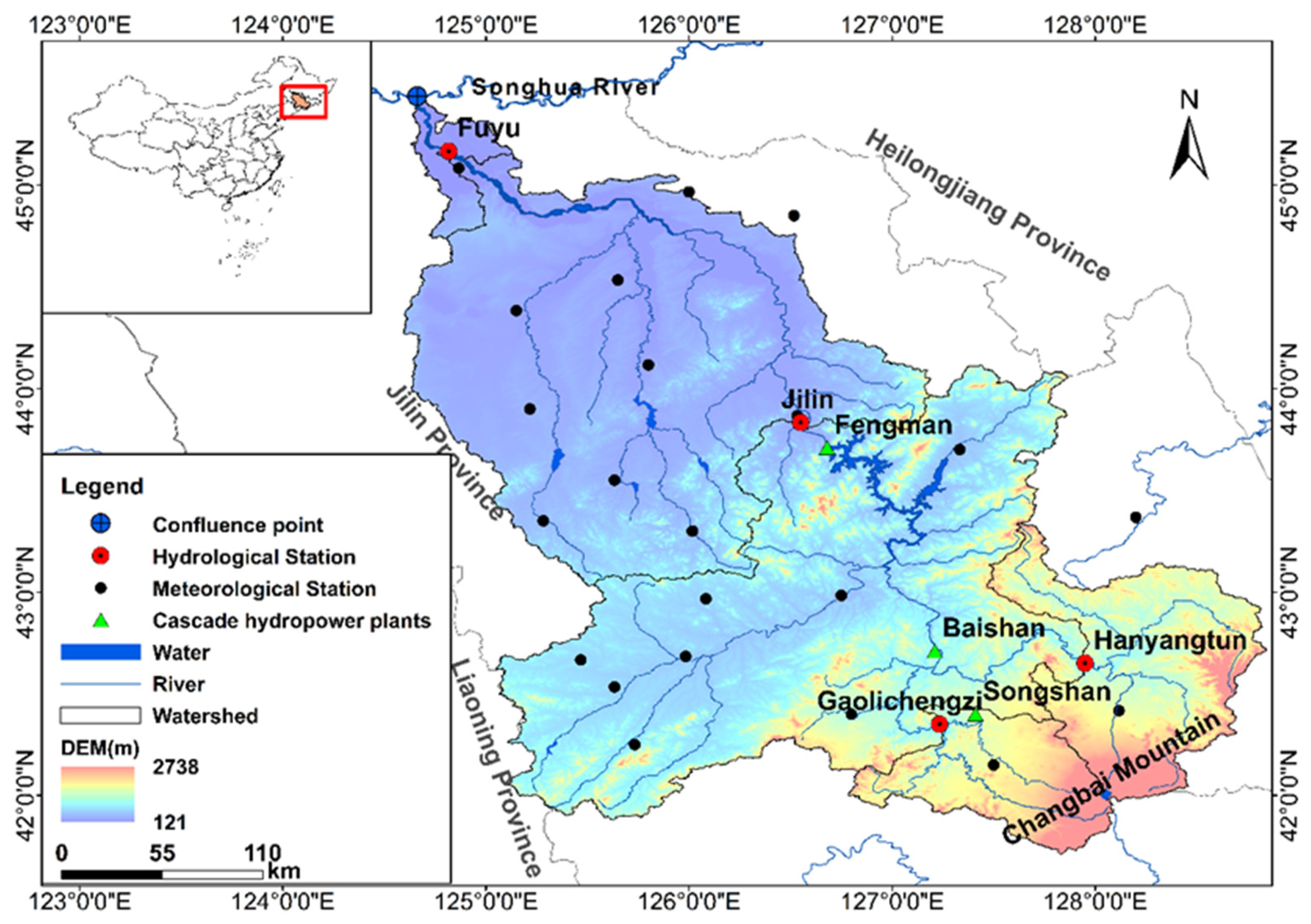
The SSR originates from Baitou Mountain, the prominent peak of Changbai Mountain. From there, it generally flows northwest for 958 km, and the total drainage basin is 73.4 thousand km2 (Figure 1). The SSR basin has a temperate continental monsoon climate with distinct seasons. The average annual precipitation in the basin is about 750 mm, most of which occurs from June to September. The average annual runoff depth is about 150–200 mm, and it peaks from the late spring through summer due to snowmelt in spring and the precipitation distribution pattern. The basin’s topography is high in the southeast and low in the northwest, with rolling mountains, lush forests, and abundant hydropower resources. Cascade hydropower plants are built in the basin, such as Songshan, Baishan, and Fengman, which play an important role in local flood control, power generation, and agricultural irrigation. The Songshan Terraced Hydropower plant is located in the southeastern mountainous area of the upper reaches of the SSR. It was completed in 2009 and had an average annual power generation of 125.7 million kWh. Baishan Hydropower plant and Fengman Hydropower plant are two large reservoirs on the mainstream of the SSR. They started generating electricity in 1983 and 1943, respectively, with an average annual capacity of 2 and 1.7 billion kWh. In addition, the Fengman Hydropower plant underwent dam reconstruction from October 2012 to September 2019 and maintained a low water level during this time.
2.2. Data Sources and Processing
Data for this study included daily meteorological data and river discharge data collected from 1989 to 2018. The daily river discharge data for four typical hydrological stations, Gaolichengzi (GLCZ), Hanyangtun (HYT), Jilin (JL), and Fuyu (FY), were obtained from the Jilin Provincial Hydrological Bureau. The daily meteorological data for 24 stations in the SSR basin were downloaded from the China Meteorological Data Sharing Service (http://data.cma.cn) (accessed on 1 February 2022). The variables included the mean temperature, max and min temperature, rainfall, relative humidity, mean wind speed, and sunshine hour. Based on these data, meteorologic and hydrologic data in monthly, seasonally, and annual scales were calculated. The potential evapotranspiration at each meteorological station was calculated using the Penman–Monteith formula [34].
where is the potential evapotranspiration (mm/d), is the slope vapor pressure curve (kpa/°C), is the net radiation at the canopy surface (MJ/ m2·d), is the soil heat flux density (MJ/m2·d), is the psychrometric constant (kPa/°C), is the mean daily air temperature (°C), is the wind speed at 2 m height (m/s), is the saturation vapor pressure (kPa), and the is actual vapor pressure (kPa).
2.3. Trends and Abrupt Change Detection
The nonparametric Mann–Kendall (M–K) test was used to assess trends of annual hydro-meteorological time series at a significance level of 0.05 [35].
The standardized M–K statistic Z indicates the trend of the tested series. If Z > 0, the tested series has an upward trend; otherwise, the series has a downward trend. At a significance level of α, if , the data series has a significant tendency, where is the quantile of the standard normal distribution. Taking the significance level of 0.05 in this study, then
= 1.96, so if > 1.96, the data series has a significant trend.
The Pettitt breakpoint test was used to detect the abrupt changes and transition year in meteorologic and hydrologic variables [26,36]. Once the transition year is detected, the data series (x1, x2, …, xN) is divided into two separate subseries (x1, x2, …, xt and xt+1, xt+2, …, xN). The test statistic was defined as follows:
When the statistic is significant, the breakpoint of the series is located at . The approximate significance probability was calculated as follows [26]:
2.4. Non-Steady Budyko Framework
With the meteorologic and hydrologic data in the SSR basin, a non-steady Budyko framework was established to evaluate the impacts of climatic factors and catchment characteristics on runoff. The framework follows Chen and Yang’s studies [26,37]. This framework is based on water balance, precipitation (), and runoff () data in different time scales, which are summarized based on daily hydrologic and meteorologic data in the SSR basin. Actual evapotranspiration (), water storage change (), and parameters representing catchment characteristics () are calculated. The fully differentiated form of the Budyko equation is as follows:
The elasticity coefficient was used to evaluate the change in runoff caused by each factor. The elasticity coefficient of precipitation () and potential evaporation () can be obtained from Equation (5).
For the selection of climatic factors, we follow the assumptions made by predecessors when applying the Budyko method [38,39]. Thus, and are categorized as climatic factors, and the others are catchment characteristics factors. The runoff change caused by climate change and catchment characteristics can be expressed as:
where is the runoff change (mm), is the climate-induced change in runoff (mm), and is catchment characteristics-induced change in runoff (mm).
The relative contribution of climate change () and catchment characteristics () to runoff changes can be calculated as:
where and are the contribution of climate change and catchment characteristics to runoff changes, respectively.
The details of the non-steady Budyko framework are provided in the Supplementary Materials.
3. Results
3.1. Variations of Runoff and Climatic Factors
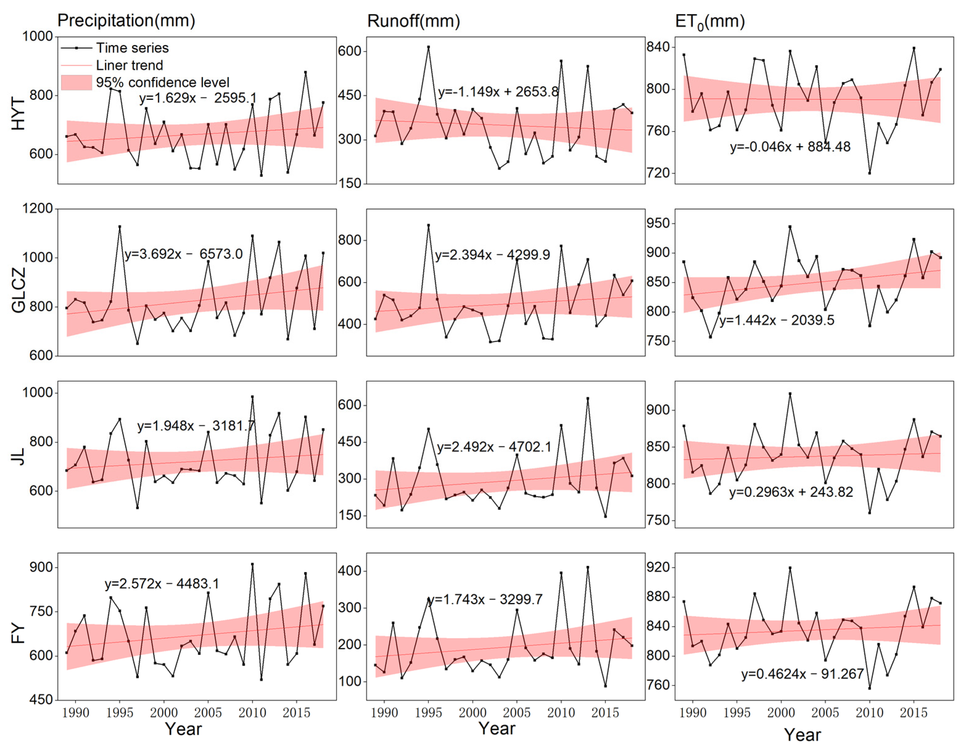
The trends of hydro-meteorological factors in each sub-basin within the SSR basin are shown in Figure 2, and the results of the M–K test are presented in Table 1. All the hydro-meteorological factors (precipitation, runoff, potential evapotranspiration) showed non-significant changes at the significance level of 0.05. The runoff showed an increasing trend except for the control basin of the HYT station. The average annual precipitation in the basin was 600–700 mm and showed an increasing trend with a change rate of 1.14–2.49 mm/a. The change in potential evapotranspiration was insignificant, especially in control basins of HYT and JL stations.
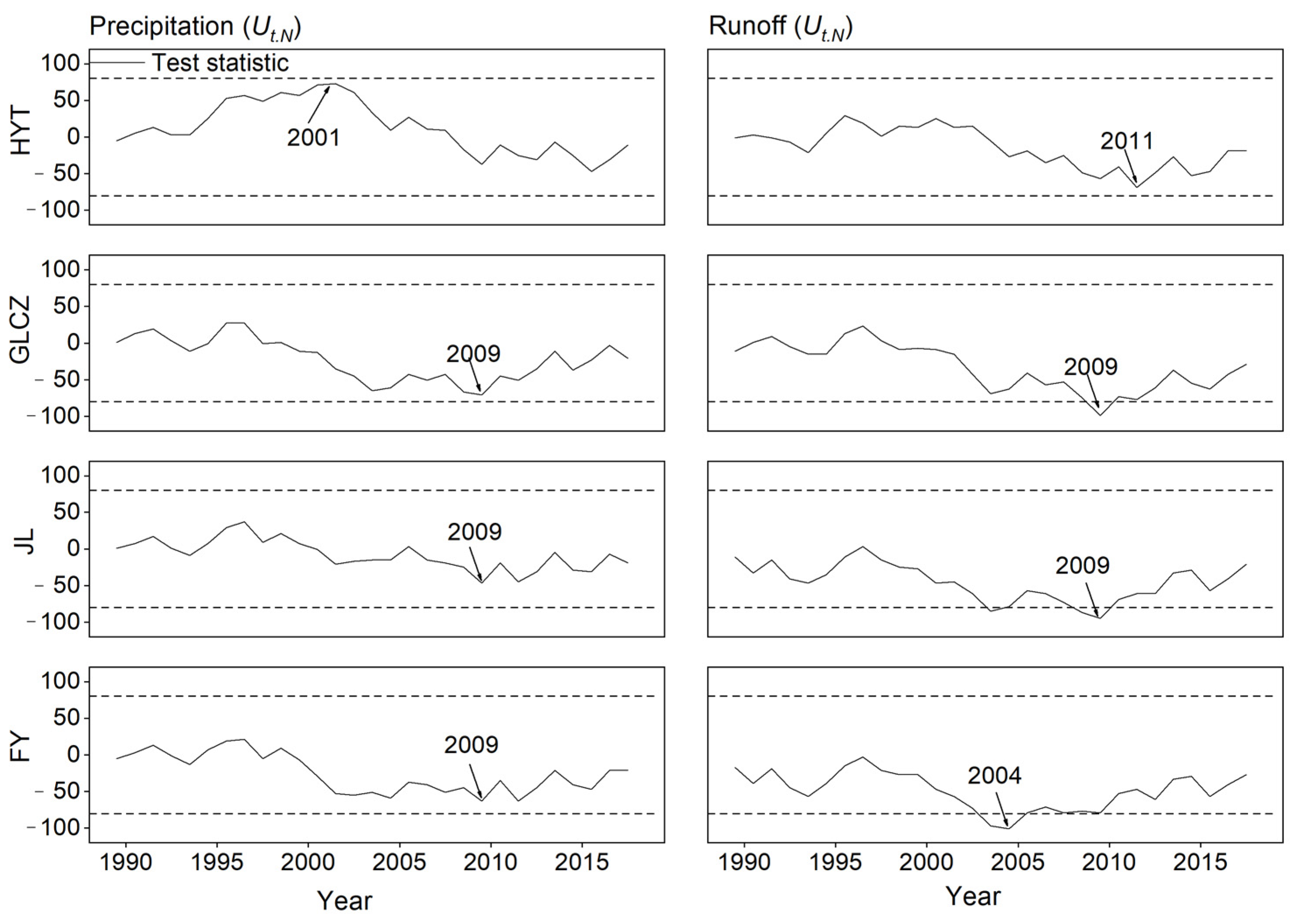
The results of the Pettitt breakpoint test are shown in Figure 3. Overall, the abrupt changes in runoff and precipitation series over the study area of the SSR basin were insignificant. The maximum absolute values of the test statistics for precipitation and runoff in most of the study areas occurred around 2009, coinciding with the changes in some catchment characteristics factors, such as the operation of some water resources projects in the SSR basin [40]. The construction of the upstream Songshan Terraced Hydropower Station was completed in 2009, which played a role in cutting the streamflow peak and replenishing the drought in the basin by storing water during periods of high rainfall and releasing water during periods of low rainfall [40,41]. Moreover, the reconstruction of Fengman Reservoir was started at the end of 2012, which kept the reservoir running at a low water level. To summarize, we set the abrupt change year as 2009, and the entire study period was divided into a baseline period (1989–2009) and a disturbed period (2010–2018).
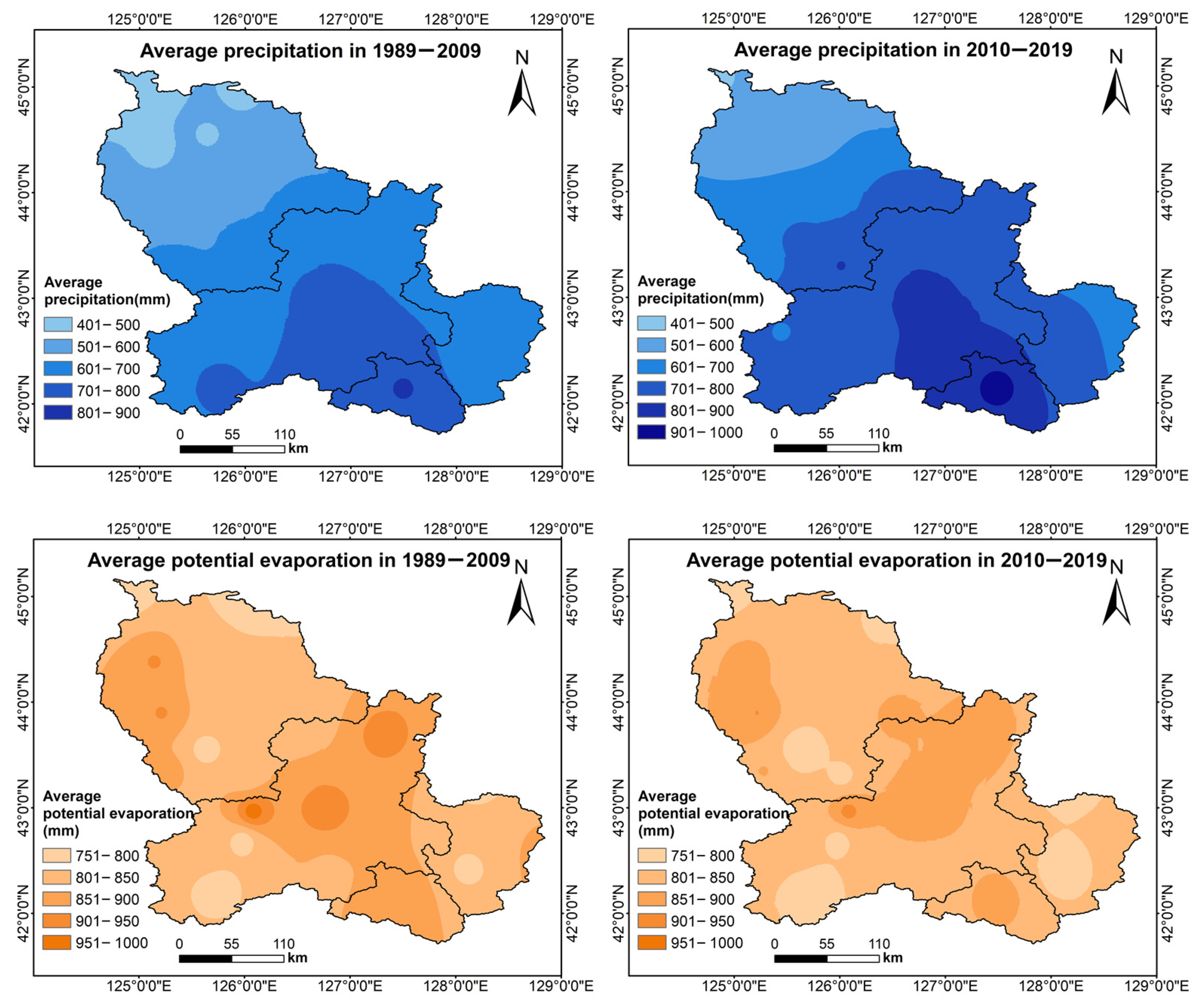
The spatial variation of precipitation and potential evapotranspiration over the study area during the baseline and disturbed periods is shown in Figure 4. The precipitation in the study area showed a downward trend from southeast to northwest throughout the study period, mainly due to the climate in the mountainous regions of Northeast China. In summer, the warm and humid air mass from the southeast forms precipitation when it meets the mountains, resulting in more rainfall in the southeastern mountains [42]. During the disturbed period, the precipitation increased compared to the baseline period, and the upward trend was more evident in the southeastern part at high altitudes. The potential evapotranspiration in the basin showed a spatial distribution pattern of being slightly higher in the middle reaches and lower in the headwaters and downstream areas. In terms of temporal variations, the potential evapotranspiration of the basin during the disturbed period decreased slightly compared with the baseline period.
3.2. Variations in the Intra-Annual Distribution of the Runoff
The intra-annual distribution of runoff at control basins of hydrological stations is shown in Figure 5. The runoff of all the basins showed an increasing trend from the baseline period to the disturbed period. The spring runoff was significantly higher at HYT and GLCZ. Similar distribution patterns have been found in the headwater areas in other studies conducted in Northeast China, possibly due to spring snowmelt [27,43]. The intra-annual runoff in the middle and lower reaches (JL and FY) showed changes, including an advance in the summer runoff peak and an increase in spring runoff.
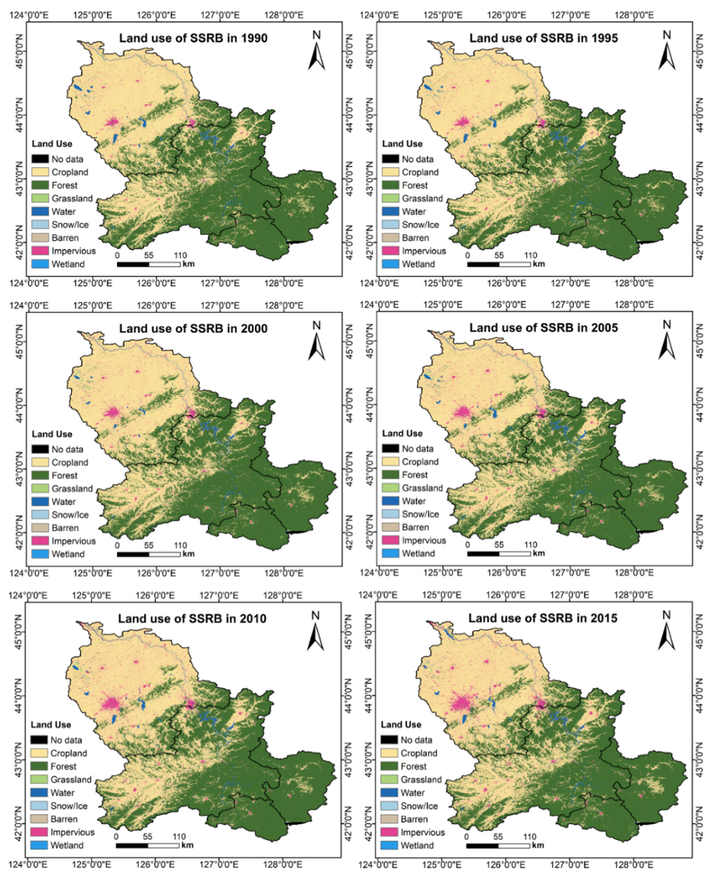
3.3. Variations in Land Use
The changes in land use in the SSR basin are shown in Figure 6. Forests and cropland are the dominant land-use patterns in this watershed and cover over 90% of the total area. Forest is the main land-use type in the upstream area, accounting for more than 90% of the total area. The cultivated land in the middle and lower reaches has increased, and the cropland area in FY basin accounts for more than 40% of the total area. The quantitative results of changes in land use in different basins are shown in Table 2. Overall, changes in land use in the SSR basin are insignificant. The cropland areas increased slightly, especially in the middle reaches, and the cities (impervious land) expanded somewhat, especially in the lower reaches. The decrease in forested area matches the increase in cropland and urban areas.
3.4. Attribution of Runoff Changes
The hydroclimatic characteristics of the sub-basins in the SSR basin are presented in Table 3. The values were positive in all sub-basins at all time scales. The values for annual, spring, summer, autumn, and winter are 0.98–1.60, 1.83–2.43, 1.23–1.58, and 0.51–0.78, respectively. Meanwhile, the values showed obvious spatial variations in different seasons. In spring and summer, the values showed an increasing trend from upstream to downstream; in winter and autumn, the values were lower in midstream and higher upstream and downstream. Unlike , the values were all negative in all sub-basins at all time scales. Meanwhile, the values showed similar seasonal and spatial changes to values. In summary, the runoff changes were more sensitive to changes in precipitation and potential evapotranspiration during summer, especially in the downstream area. In addition, the values were lower than in all seasons, suggesting that runoff changes were more sensitive to precipitation changes.
The results of the attribution analysis of runoff changes in the SSR basin are presented in Table 4. The changes in annual runoff showed spatial variations in the order of GLCZ > JL > FY > HYT. The changes in precipitation might be an important reason for this spatial distribution of , as the annual and showed a positive correlation. This is consistent with the discussions above; the GLCZ basin, as a southeastern mountainous area, receives more precipitation due to the humid airmass from the sea. In terms of seasonal changes, runoff changes mainly occurred in spring in the upstream areas and mainly in summer in the middle and lower reaches. Spring runoff variation accounted for 59% and 35% of the yearly runoff variation in the HYT and GLCZ watersheds, respectively. Summer runoff changes accounted for 59 and 59% of the annual runoff changes in the JL and FY watersheds, respectively.
Climatic factors played a role in increasing runoff at all spatial and temporal scales. In contrast, the impact of catchment characteristics on runoff varied in different areas over time. Changes in runoff due to catchment characteristics occurred most in summer in the HYT, JL, and FY basins. In the three basins, summer runoff variations due to catchment characteristics accounted for 67, 60, and 50% of the total changes induced by catchment characteristics, respectively. In the GLCZ basin, summer runoff changes due to catchment characteristics accounted for about 38% of the total changes, slightly lower than winter (48%). In addition, there were spatial variations in the impact of catchment characteristics on summer runoff, resulting in a decrease in runoff upstream and an increase in runoff downstream.
As shown in Table 4, the changes in annual runoff were mainly caused by climate change, with an average contribution of 61.4–94.3%. Precipitation was the main climatic factor that affected the runoff process. The of the annual runoff showed spatial changes, which were highest in FY, followed by HYT and GLCZ, and lowest in JL. The contribution of climatic factors to seasonal runoff changes exhibited seasonal variations. The values of spring, summer, autumn, and winter were 64.7–100%, 22.8–62.5%, 65.2–91.3%, and 16.7–40.0%, respectively, indicating that climate change had a greater impact on spring and autumn runoff, and less of an impact on summer and winter runoff. The intensity of catchment characteristics effects on seasonal runoff was opposite to that of climate change. The values of spring, summer, autumn, and winter were 0–35.3%, 37.5–77.2%, 8.7–34.8%, and 60.0–83.3%, respectively.
4. Discussion
Based on attribution analysis results, we found that the runoff was significantly influenced by climate change in the SSR basin. The catchment characteristics have a relatively low impact on the yearly runoff but have a more significant effect on the intra-annual distribution of runoff. A detailed discussion of the impact of climate change and catchment characteristics on runoff follows:
4.1. Attribution Analysis of Climate Change to Runoff Changes
In the Budyko framework, precipitation and potential evapotranspiration are usually considered climatic factors [39]. According to the attribution analysis results above, the increased annual runoff in the SSR basin was related to the increasing annual precipitation and decreasing potential evapotranspiration. The contributions of climate change to annual runoff change were 61.4–94.3%. These results differ from the results of Zhang’s research, which reported that the runoff in the SSR basin decreased from 1960 to 2016, and the average contribution of climate change to annual runoff change was only 38.5% [32]. This is probably due to the very low intensity of human activities in the 1960s and 1970s [44], so the runoff process changed significantly when human activities intensified in the late 1970s. Our study focused on the last 30 years; in this period, catchment characteristics have not changed as much as from 1960s to 2010s.
The increased precipitation had a great positive effect on runoff. Si et al. found the summer precipitation in Northeast Asia in the 20th century experienced three interdecadal variations in the 1920s, mid-1960s, and late 1990s [45]. Since late 1990s, the summer rainfall in Northeast Asia is above normal precipitation, which is due to the anomalous Northeast Asia cold vortex and strong East Asian summer monsoon caused by the Atlantic Multidecadal Oscillation. Li et al. reported that the increased spring rainfall from 1979 to 2017 in Northeast China was mainly due to the increased warm and wet air brought by the southerlies [46]. According to Wu’s research, there are drought–flood transitions in Northeast China during the long-term climatic cycle [47]. The drought events in the baseline period in this study are more than in the disturbed period. Above all, the study period included wet decades in the SSR basin, and the disturbed period was wetter than the baseline period. Therefore, the increased precipitation caused by atmospheric circulation changes was the main reason for the increased runoff in the SSR basin.
4.2. Attribution Analysis of Catchment Characteristics to Runoff Changes
The impacts of catchment characteristics on runoff are reflected in changes in water extraction, land use, and land cover [38]. Since 1989, there have been significant changes in water extraction and underlying surface characteristics in the SSR basin. According to the Statistical Yearbook of Jilin Province, the real GDP of the SSR basin increased significantly during the study period, from 159.2 billion yuan (average in the baseline period) to 882.2 billion yuan (average in the disturbed period). Moreover, the farmland and urban areas have slightly increased in the middle and lower reaches (Figure 6). Rapidly growing GDP and more farmland and cities will undoubtedly increase water use in the watershed. According to the Jilin Province Water Resources Bulletin, the annual water consumption in the SSR basin during the disturbed period (7.74 billion cubic meters on average) increased relative to the baseline period (6.18 billion cubic meters on average). However, as shown in Table 4, catchment characteristics increased runoff in some seasons, which might be attributed to the changes in deforestation, operation of reservoirs, or earlier snowmelt. Detailed discussions of the impacts of catchment characteristics on runoff in different seasons are listed below.
- (1).
- Impacts of catchment characteristics on spring runoff
Despite the raised withdrawals, changes in catchment characteristics in the upstream region resulted in constant or increased spring runoff, indicating that other factors increased the runoff. As the SSR basin is located in mid-to-high latitudes, changes in snowmelt and frozen soils would affect runoff. According to Tian and Li’s research, the snowfall has increased in the Changbai Mountain Area in the upper reaches of the SSR basin [48,49]. Thus, the increased snowmelt caused by more snowfall in winter was the main reason for the increasing runoff in spring in the upstream region, while the decreased spring runoff in downstream areas was probably due to greater water pumping and degrading seasonally frozen soil. In recent years, due to the temperature rise, the seasonally frozen soil in downstream areas has thawed earlier, and the thawed area is larger. It can completely melt by the end of April, leading to increased infiltration and reduced runoff.
- (2).
- Impacts of catchment characteristics on summer runoff
The summer runoff was significantly influenced by catchment characteristics, especially in the downstream areas, with values up to 77.2% (Table 4). The decreased runoff in the upstream areas is mainly associated with the larger water pumping and accelerated degradation of permafrost and seasonally frozen soil. According to Tian and Chang’s study [43,48], seasonally frozen soil can maintain until early June in the upper reaches of the SSR basin due to the higher altitude. Therefore, in recent decades the degrading permafrost and seasonally frozen soil could have increased infiltration and significantly reduced summer runoff.
Since the Fengman Reservoir upstream of the JL station has been in use for a long time, its dam has potential safety hazards. In October 2012, the new dam began to be constructed and was put into operation in September 2019. During this period, in order to ensure the dam’s safety, the Fengman Reservoir operated at a low water level, especially in summer [50,51]. According to Jilin Water Resources Bulletin, the storage volume of Fengman Reservoir was significantly lower during the construction period than the historical storage volume in the same period (https://www.hydrojl.net/) (accessed on 12 December 2022). Therefore, the increase in water release from Fengman Reservoir was probably the main reason for the increased summer runoff in the downstream areas. Moreover, due to the high infiltration capacity of forests, changes in forest area can have a significant impact on the distribution of intra-annual runoff. According to Garcia’s study, the decrease in forest area in the Greek region causes a higher runoff in the rainy season [22]. Thus, the slight decrease in forest area in the downstream areas in the SSR basin might also have contributed to the increase in summer runoff.
- (3).
- Impacts of catchment characteristics on autumn runoff
Catchment characteristics have little effect on autumn runoff, with values ranging from 8.7 to 34.9%, and the values are small, ranging from −3 to 8 mm. Catchment characteristics increased runoff in all the basins except for FY, which is probably associated with changes in proportion of snowfall in precipitation. As discussed above, runoff in the SSR basin is significantly influenced by snowfall. According to previous studies, it started snowing in October in the SSR basin. While in the context of global warming, the first snowfall in the SSR basin was delayed backward. Compared with the 1980s, the date of the first snowfall in 2018 was delayed by about ten days [52]. Thus, the proportion of snowfall in precipitation in the disturbed period was lower than that in the baseline period, resulting in more runoff, which was probably one reason for the slight increase in autumn runoff. Moreover, the freezing time of rivers has also been delayed, also increasing the monitored runoff to a certain extent.
- (4).
- Impacts of catchment characteristics on winter runoff
The runoff change value caused by catchment characteristics () in winter was not large. However, the contribution of catchment characteristics () to runoff is the highest in all the seasons due to the same little changes in runoff caused by climatic factors () in winter. The decreased runoff in HYT, JL, and FY basins was due to larger water pumping. In addition, the increased runoff in GLCZ basin was mainly attributed to the operation of Songshan Terraced Hydropower Station [40], which homogenized the intra-annual distribution of runoff, reduced summer flood peaks, and increased winter runoff. Although there are other reservoirs in the SSR basin, only the Songshan Terraced Hydropower Station was put into operation during our study period. The Fengman Reservoir and Baishan Reservoir construction in the SSR basin was relatively early and began operation before the study period. Moreover, there were no apparent changes in their operation in winter.
Based on the results of this paper, the following suggestions are proposed for the sustainable use and management of water resources in the SSR basin. Runoff increased in all regions of the basin, with significant increases in spring runoff in the upper reaches and summer runoff in the middle and lower reaches, which increases flood risks. Qi et al. obtained similar results of increased flood risks in the SSR basin [53]. Therefore, there is a need to strengthen the forecasting and prevention of spring floods in the upstream area as well as summer floods in the downstream area. According to the results of attribution analysis, the runoff changes were mainly caused by climate change in the SSR basin. Meanwhile, changes in catchment characteristics also affected the runoff process, especially the seasonal runoff. Thus, the long-term prediction of water resources in the SSR basin under the influence of climate change and catchment characteristics changes should be strengthened to prevent the risk of water shortage or flooding.
4.3. Uncertainty Analysis
In this study, we applied the elasticity coefficient method to analyze the runoff change of the SSR basin using the Budyko framework. Nevertheless, there are still some uncertainties in the results of this research. The upstream areas of the SSR are located in the Changbai Mountain area, which experience very active climate change [54]. However, there are relatively few meteorological observations in this region, which may lead to some bias [55].
The impact of runoff change is a very complex process, but the elasticity coefficient method considers climate change and catchment characteristics independent of each other [56]. Although many studies have successfully separated the effects of climate change and catchment characteristics on runoff using the elasticity coefficient method, they still cannot accurately separate the association between them. Usually, climatic factors contain precipitation, temperature, pressure, humidity, wind, etc. The Budyko hypothesis only considers precipitation and potential evapotranspiration as climatic factors. In addition, some factors, such as seasonal permafrost degradation, are affected by both climate change and human activities simultaneously. Thus, further differentiation of climatic and catchment characteristics factors is needed in future studies.
5. Conclusions
In this study, we used a Budyko framework suitable for non-steady conditions to quantitatively estimate the impacts of climate change and catchment characteristics change on the long-term changes in annual and seasonal runoff in the SSR basin from 1989 to 2018. The results showed that the Budyko framework works well in assessing the influence of climate and catchment characteristics changes on the long-term changes in annual and seasonal runoff. At the same time, it was found that climate change and catchment characteristics changes have different effects on annual runoff and seasonal runoff, so the attribution analysis of seasonal runoff changes is of great significance. The detailed conclusions are as follows:
- (1).
- The runoff of the SSR basin exhibited a non-significant increasing trend in the last 30 years, and an abrupt change occurred in 2009. Compared with the baseline period, the runoff in the disturbed period increased, the upstream spring runoff increased significantly, and the downstream summer runoff increased dramatically.
- (2).
- According to results of elasticity coefficient and attribution analysis, changes in runoff in the SSR watershed are mainly due to climate change caused by atmospheric circulation variations. The contributions of climate change to the annual runoff changes were 61.4–94.3%.
- (3).
- The impacts of catchment characteristics on annual runoff in the SSR basin were minor, while they significantly impacted seasonal runoff. Catchment characteristics significantly impacted summer and winter runoff, contributing to 77.2 and 83.3% for summer and winter runoff changes.
- (4).
- In addition to increased water withdrawals in the basin, increased snowfall, delayed onset of snowfall, delayed river freezing, degradation of permafrost and seasonal permafrost, and operational changes in hydropower stations all affect seasonal runoff in the SSR basin.
According to the findings above, there is a need to strengthen the long-term prediction of yearly and seasonal runoff in the SSR basin under the influence of climate change and catchment characteristics to prevent the risk of water shortage or flooding. Moreover, further differentiation of climatic and catchment characteristics factors is needed in future studies.
Supplementary Materials
The following supporting information can be downloaded at: https://www.mdpi.com/article/10.3390/w15030451/s1, the details of the non-steady Budyko framework.
Author Contributions
Data curation, Z.L. and Y.S.; Funding acquisition, Y.W. and Z.L.; Methodology, Y.W. and P.Q.; Software, J.L.; Visualization, J.S.; Writing—original draft, Z.L.; Writing—review and editing, Y.W. All authors have read and agreed to the published version of the manuscript.
Funding
This research was funded by the National Key Research and Development Program of China, grant number 2019YFC0409103; the National Natural Science Foundation of China, grant number 41907156; Jilin Province Science and Technology Development Plan, grant number 20220508098RC; Heilongjiang University postgraduate innovative Research Project, grant number YJSCX2022-097HLJU.
Institutional Review Board Statement
Not applicable.
Data Availability Statement
The daily meteorological data for 24 stations in the SSR basin were downloaded from the China Meteorological Data Sharing Service (http://data.cma.cn) (accessed on 1 February 2022). Reservoir data from Jilin Water Resources Bulletin (https://www.hydrojl.net/) (accessed on 12 December 2022).
Acknowledgments
Yao Wu acknowledges support from the Scholarship of the Chinese Academy of Sciences.
Conflicts of Interest
The authors declare no conflict of interest.
References
- Birsan, M.-V.; Molnar, P.; Burlando, P.; Pfaundler, M. Streamflow trends in Switzerland. J. Hydrol. 2005, 314, 312–329. [Google Scholar] [CrossRef]
- Chien, H.; Yeh, P.J.-F.; Knouft, J.H. Modeling the potential impacts of climate change on streamflow in agricultural watersheds of the Midwestern United States. J. Hydrol. 2013, 491, 73–88. [Google Scholar] [CrossRef]
- McCabe, G.J.; Wolock, D.M. A step increase in streamflow in the conterminous United States. Geophys. Res. Lett. 2002, 29, 38-1–38-4. [Google Scholar] [CrossRef]
- Dai, A.; Qian, T.; Trenberth, K.E.; Milliman, J.D. Changes in continental freshwater discharge from 1948 to 2004. J. Clim. 2009, 22, 2773–2792. [Google Scholar] [CrossRef]
- Milly, P.C.; Betancourt, J.; Falkenmark, M.; Hirsch, R.M.; Kundzewicz, Z.W.; Lettenmaier, D.P.; Stouffer, R.J. Stationarity is dead: Whither water management? Science 2008, 319, 573–574. [Google Scholar] [CrossRef] [PubMed]
- Wang, D.; Hejazi, M. Quantifying the relative contribution of the climate and direct human impacts on mean annual streamflow in the contiguous United States. Water Resour. Res. 2011, 47, W00J12. [Google Scholar] [CrossRef] [Green Version]
- Jiang, C.; Xiong, L.; Wang, D.; Liu, P.; Guo, S.; Xu, C.-Y. Separating the impacts of climate change and human activities on runoff using the Budyko-type equations with time-varying parameters. J. Hydrol. 2015, 522, 326–338. [Google Scholar] [CrossRef]
- Merz, B.; Vorogushyn, S.; Uhlemann, S.; Delgado, J.; Hundecha, Y. HESS Opinions "More efforts and scientific rigour are needed to attribute trends in flood time series". Hydrol. Earth Syst. Sci. 2012, 16, 1379–1387. [Google Scholar] [CrossRef] [Green Version]
- Mango, L.M.; Melesse, A.M.; McClain, M.E.; Gann, D.; Setegn, S.G. Land use and climate change impacts on the hydrology of the upper Mara River Basin, Kenya: Results of a modeling study to support better resource management. Hydrol. Earth Syst. Sci. 2011, 15, 2245–2258. [Google Scholar] [CrossRef] [Green Version]
- Xu, X.; Yang, D.; Yang, H.; Lei, H. Attribution analysis based on the Budyko hypothesis for detecting the dominant cause of runoff decline in Haihe basin. J. Hydrol. 2014, 510, 530–540. [Google Scholar] [CrossRef]
- Bourgault, M.A.; Larocque, M.; Roy, M. Simulation of aquifer-peatland-river interactions under climate change. Hydrol. Res. 2014, 45, 425–440. [Google Scholar] [CrossRef]
- Schilling, K.E.; Chan, K.-S.; Liu, H.; Zhang, Y.-K. Quantifying the effect of land use land cover change on increasing discharge in the Upper Mississippi River. J. Hydrol. 2010, 387, 343–345. [Google Scholar] [CrossRef]
- Vogel, R.M.; Wilson, I.; Daly, C. Regional regression models of annual streamflow for the United States. J. Irrig. Drain. Eng. 1999, 125, 148–157. [Google Scholar] [CrossRef]
- Gardner, L.R. Assessing the effect of climate change on mean annual runoff. J. Hydrol. 2009, 379, 351–359. [Google Scholar] [CrossRef]
- Roderick, M.L.; Farquhar, G.D. A simple framework for relating variations in runoff to variations in climatic conditions and catchment properties. Water Resour. Res. 2011, 47, 1–11. [Google Scholar] [CrossRef] [Green Version]
- Li, C.; Wang, L.; Wanrui, W.; Qi, J.; Linshan, Y.; Zhang, Y.; Lei, W.; Cui, X.; Wang, P. An analytical approach to separate climate and human contributions to basin streamflow variability. J. Hydrol. 2018, 559, 30–42. [Google Scholar] [CrossRef]
- Shahid, M.; Cong, Z.; Zhang, D. Understanding the impacts of climate change and human activities on streamflow: A case study of the Soan River basin, Pakistan. Theor. Appl. Climatol. 2018, 134, 205–219. [Google Scholar] [CrossRef]
- Young, D.; Zegre, N.; Edwards, P.; Fernandez, R. Assessing streamflow sensitivity of forested headwater catchments to disturbance and climate change in the central Appalachian Mountains region, USA. Sci. Total Environ. 2019, 694, 133382. [Google Scholar] [CrossRef]
- Budyko, M.I. The heat balance of the earth’s surface. Sov. Geogr. 1961, 2, 3–13. [Google Scholar] [CrossRef]
- Budyko, M.I. Climate and Life; Academic Press: Cambridge, MA, USA, 1974. [Google Scholar]
- Xu, J.; Yang, D.; Yi, Y.; Lei, Z.; Chen, J.; Yang, W. Spatial and temporal variation of runoff in the Yangtze River basin during the past 40 years. Quat. Int. 2008, 186, 32–42. [Google Scholar] [CrossRef]
- Garcia, C.; Amengual, A.; Homar, V.; Zamora, A. Losing water in temporary streams on a Mediterranean island: Effects of climate and land-cover changes. Glob. Planet. Change 2017, 148, 139–152. [Google Scholar] [CrossRef]
- Zhang, Q.; Xiao, M.; Singh, V.P.; Xu, C.-Y.; Li, J. Variations of annual and seasonal runoff in Guangdong Province, south China: Spatiotemporal patterns and possible causes. Meteorol. Atmos. Phys. 2015, 127, 273–288. [Google Scholar] [CrossRef]
- Montaldo, N.; Oren, R. Changing Seasonal Rainfall Distribution With Climate Directs Contrasting Impacts at Evapotranspiration and Water Yield in the Western Mediterranean Region. Earth’s Future 2018, 6, 841–856. [Google Scholar] [CrossRef]
- Mianabadi, A.; Davary, K.; Pourreza-Bilondi, M.; Coenders-Gerrits, A.M.J. Budyko framework; towards non-steady state conditions. J. Hydrol. 2020, 588, 125089. [Google Scholar] [CrossRef]
- Chen, X.; Alimohammadi, N.; Wang, D. Modeling interannual variability of seasonal evaporation and storage change based on the extended Budyko framework. Water Resour. Res. 2013, 49, 6067–6078. [Google Scholar] [CrossRef] [Green Version]
- Qi, P.; Huang, X.; Xu, Y.J.; Li, F.; Wu, Y.; Chang, Z.; Li, H.; Zhang, W.; Jiang, M.; Zhang, G.; et al. Divergent trends of water bodies and their driving factors in a high-latitude water tower, Changbai Mountain. J. Hydrol. 2021, 603, 127094. [Google Scholar] [CrossRef]
- Wu, Y.; Sun, J.; Xu, Y.J.; Zhang, G.; Liu, T. Projection of future hydrometeorological extremes and wetland flood mitigation services with different global warming levels: A case study in the Nenjiang river basin. Ecol. Indic. 2022, 140, 108987. [Google Scholar] [CrossRef]
- Fang, Y.-H.; Chen, K.-Q.; Chen, H.-S.; Xu, S.-Q.; Geng, X.; Li, T.-Y.; Teng, F.-D.; Zhou, X.-Y.; Wang, Y.-G. The Remote Responses of Early Summer Cold Vortex Precipitation in Northeastern China to the precedent Sea Surface Temperatures. Atmos. Res. 2018, 214, 399–409. [Google Scholar] [CrossRef]
- Li, H.; Bao, S.; Wang, X.; Lv, H. Storm Flood Characteristics and Identification of Periodicity for Flood-Causing Rainstorms in the Second Songhua River Basin. Water 2016, 8, 529. [Google Scholar] [CrossRef] [Green Version]
- Zhu, D.; Zhi, X.; Sein, Z.M.M.; Ji, Y.; Tian, X.; Pan, M. Possible Relationships between the Interdecadal Anomalies of Heavy Rainfall under Northeastern China Cold Vortexes and the Sea Surface Temperature (SST). Atmosphere 2022, 13, 354. [Google Scholar] [CrossRef]
- Zhang, S.; Liu, J.; Li, C.; Yu, F.; Jing, L.; Sun, J. Analyzing the Impact of Climate Change and Human Activities on Surface Runoff in the Changbai Mountain Area, Northeast China. Water 2021, 13, 3473. [Google Scholar] [CrossRef]
- Bao, S.; Yang, W.; Wang, X.; Li, H. Quantifying Contributions of Climate Change and Local Human Activities to Runoff Decline in the Second Songhua River Basin. Water 2020, 12, 2659. [Google Scholar] [CrossRef]
- Howell, T.A.; Evett, S. The Penman-Monteith Method; USDA-Agricultural Research Service, Conservation Production Research Laboratory: Washington, DC, USA, 2004; p. 14. [Google Scholar]
- Kendall, M.; Gibbons, J.D. Rank Correlation Methods; Charles Griffin Book Series; Oxford University Press: Oxford, UK, 1990. [Google Scholar]
- Pettitt, A.N. A non-parametric approach to the change-point problem. J. R. Stat. Soc. Ser. C 1979, 28, 126–135. [Google Scholar] [CrossRef]
- Yang, H.; Yang, D. Derivation of climate elasticity of runoff to assess the effects of climate change on annual runoff. Water Resour. Res. 2011, 47, 9287. [Google Scholar] [CrossRef]
- Xin, Z.; Li, Y.; Zhang, L.; Ding, W.; Ye, L.; Wu, J.; Zhang, C. Quantifying the relative contribution of climate and human impacts on seasonal streamflow. J. Hydrol. 2019, 574, 936–945. [Google Scholar] [CrossRef]
- Han, Z.; Long, D.; Fang, Y.; Hou, A.; Hong, Y. Impacts of climate change and human activities on the flow regime of the dammed Lancang River in Southwest China. J. Hydrol. 2019, 570, 96–105. [Google Scholar] [CrossRef]
- Qian, W. Dispatching of cascade hydropower stations in Songjiang River Basin. Jilin Water Resour. 2012, 11, 49–51. (In Chinese) [Google Scholar] [CrossRef]
- Li, B.; Bian, D.; Qu, H.; Yang, Z.; Zhao, R.; Hu, C. The Problems and Control Countermeasures Research of Rural Drinking Water Resource in Jilin. In Proceedings of the 2012 International Conference on Biomedical Engineering and Biotechnology, Macau, China, 28–30 May 2012; pp. 1841–1844. [Google Scholar]
- Napoli, A.; Crespi, A.; Ragone, F.; Maugeri, M.; Pasquero, C. Variability of orographic enhancement of precipitation in the Alpine region. Sci. Rep. 2019, 9, 1–8. [Google Scholar] [CrossRef] [Green Version]
- Chang, Z.; Qi, P.; Zhang, G.; Sun, Y.; Tang, X.; Jiang, M.; Sun, J.; Li, Z. Latitudinal characteristics of frozen soil degradation and their response to climate change in a high-latitude water tower. Catena 2022, 214, 1–15. [Google Scholar] [CrossRef]
- Huang, S.; Fidrmuc, J.; Fidrmuc, J. Whither China? Reform and economic integration among Chinese regions. China Econ. Rev. 2015, 33, 94–110. [Google Scholar] [CrossRef]
- Si, D.; Jiang, D.; Hu, A.; Lang, X. Variations in northeast Asian summer precipitation driven by the Atlantic multidecadal oscillation. Int. J. Climatol. 2020, 41, 1682–1695. [Google Scholar] [CrossRef]
- Li, X.; Sun, J.; Zhang, M.; Zhang, Y.; Ma, J. Possible connection between declining Barents Sea ice and interdecadal increasing northeast China precipitation in May. Int. J. Climatol. 2021, 41, 6270–6282. [Google Scholar] [CrossRef]
- Wu, X.; Zhou, J.; Yu, H.; Liu, D.; Xie, K.; Chen, Y.; Hu, J.; Sun, H.; Xing, F. The Development of a Hybrid Wavelet-ARIMA-LSTM Model for Precipitation Amounts and Drought Analysis. Atmosphere 2021, 12, 74. [Google Scholar] [CrossRef]
- Tian, L. Research on Spring Snowmelt Runoff in the Middle Temperate Zone—A Case Study of Baishan Reservoir Basin in the Second Songhua River; Jilin University: Changchun, China, 2019. [Google Scholar]
- Li, W.; Yang, W.; Wang, A.; Li, H.; Tian, L. Analysis for the composition of spring runoff in Fengman Basin. Water Resour. Hydropower Eng. 2019, 50, 45–52. (In Chinese) [Google Scholar] [CrossRef]
- Lu, Z.; Wang, T.; Meng, J.; Li, X.; Wang, Y.; Wang, S. Study of flood dispatching and water supply guarantee scheme for construction period of Fengman Hydropower Station Reconstruction Project. Water Resour. Hydropower Eng. 2016, 47, 18–21. (In Chinese) [Google Scholar] [CrossRef]
- Wang, Y.; Li, W.; Wang, J. Reservoir dispatching during construction of Comprehensive Treatment (Reconstruction) Project of Fengman Hydropower Station. Water Resour. Hydropower Eng. 2020, 51, 138–142. (In Chinese) [Google Scholar] [CrossRef]
- Wang, L.; Huang, X.; Ren, J.; Ma, Y.; Liu, Y. Spatiotemporal Change of the Beginning and Ending Dates of Snowfall in Jilin Province. Arid. Zone Res. (In Chinese). 2019, 36, 980–989. [Google Scholar] [CrossRef]
- Qi, W.; Feng, L.; Yang, H.; Liu, J. Spring and summer potential flood risk in Northeast China. J. Hydrol. Reg. Stud. 2021, 38, 100951. [Google Scholar] [CrossRef]
- Sun, R.; Chen, J.; Zhu, Q.; Zhou, Y.; Liu, J.; Li, J.; Liu, S.; Yan, G.; Tang, S. Spatial distribution of net primary productivity and evapotranspiration in Changbaishan Natural Reserve, China, using Landsat ETM+ data. Can. J. Remote Sens. 2004, 30, 731–742. [Google Scholar] [CrossRef]
- Liu, Y.; Xu, J.; Yuan, Z.; Sha, Z. Analysis of the influence of the water balance process on the change of landscape patterns in the upper reaches of the Yangtze River. Water Policy 2022, 24, 261–281. [Google Scholar] [CrossRef]
- Wu, J.; Miao, C.; Wang, Y.; Duan, Q.; Zhang, X. Contribution analysis of the long-term changes in seasonal runoff on the Loess Plateau, China, using eight Budyko-based methods. J. Hydrol. 2017, 545, 263–275. [Google Scholar] [CrossRef]
Figure 1.
Locations of the SSR basin and hydro-meteorological stations.

Figure 2.
Trends in precipitation, runoff, and potential evapotranspiration of sub-basins controlled by HYT, GLCZ, JL, and FY stations from 1989 to 2018.
Figure 2.
Trends in precipitation, runoff, and potential evapotranspiration of sub-basins controlled by HYT, GLCZ, JL, and FY stations from 1989 to 2018.

Figure 3.
Results of Pettitt breakpoint test of the SSR basin.

Figure 4.
Spatial distribution map of precipitation and potential evapotranspiration in the baseline and disturbed periods of the SSR basin.
Figure 4.
Spatial distribution map of precipitation and potential evapotranspiration in the baseline and disturbed periods of the SSR basin.

Figure 5.
Intra-annual runoff distribution of the baseline period and disturbed period.

Figure 6.
Land-use area in SSR basin during the study period.


Table 1.
Z-values for M–K trend test of precipitation, runoff, and potential evapotranspiration from 1989–2018.
Table 1.
Z-values for M–K trend test of precipitation, runoff, and potential evapotranspiration from 1989–2018.
| HYT | GLCZ | JL | FY | |
|---|---|---|---|---|
| Precipitation | 0.18 | 0.57 | 0.07 | 0.54 |
| Runoff | −0.47 | 0.57 | 1.12 | 1.15 |
| Potential evapotranspiration | 0.13 | 1.17 | 0.6 | 0.81 |
Table 2.
Land-use area in sub-basins during the study period.
| Catchment | Year | Cropland | Forest | Grassland | Water | Impervious |
|---|---|---|---|---|---|---|
| GLCZ | 1990 | 5.1% | 93.1% | 1.2% | 0.1% | 0.4% |
| 1995 | 4.2% | 94.4% | 0.7% | 0.1% | 0.5% | |
| 2000 | 3.7% | 94.9% | 0.6% | 0.1% | 0.6% | |
| 2005 | 4.3% | 94.4% | 0.4% | 0.1% | 0.7% | |
| 2010 | 4.0% | 94.8% | 0.3% | 0.1% | 0.8% | |
| 2015 | 5.1% | 93.3% | 0.4% | 0.1% | 0.9% | |
| HYT | 1990 | 5.3% | 93.0% | 0.3% | 0.1% | 0.2% |
| 1995 | 4.7% | 93.7% | 0.2% | 0.1% | 0.3% | |
| 2000 | 5.3% | 93.1% | 0.2% | 0.1% | 0.3% | |
| 2005 | 4.6% | 93.7% | 0.2% | 0.1% | 0.4% | |
| 2010 | 4.2% | 94.1% | 0.2% | 0.1% | 0.4% | |
| 2015 | 6.0% | 92.2% | 0.2% | 0.1% | 0.5% | |
| JL | 1990 | 23.4% | 74.3% | 0.3% | 1.0% | 0.9% |
| 1995 | 23.2% | 74.3% | 0.2% | 1.0% | 1.0% | |
| 2000 | 22.8% | 74.7% | 0.1% | 1.0% | 1.2% | |
| 2005 | 25.7% | 71.4% | 0.1% | 1.2% | 1.4% | |
| 2010 | 26.3% | 70.8% | 0.1% | 1.1% | 1.5% | |
| 2015 | 27.4% | 69.5% | 0.1% | 1.1% | 1.8% | |
| FY | 1990 | 44.5% | 51.7% | 0.4% | 1.2% | 1.9% |
| 1995 | 44.5% | 51.5% | 0.3% | 1.3% | 2.2% | |
| 2000 | 44.3% | 51.4% | 0.4% | 1.0% | 2.6% | |
| 2005 | 45.5% | 49.5% | 0.4% | 1.3% | 3.1% | |
| 2010 | 46.0% | 48.7% | 0.4% | 1.3% | 3.5% | |
| 2015 | 46.3% | 47.9% | 0.3% | 1.2% | 4.0% |
Table 3.
Hydroclimatic characteristics and elasticity of runoff for the four sub-basins in the SSR basin.
Table 3.
Hydroclimatic characteristics and elasticity of runoff for the four sub-basins in the SSR basin.
| Time Step | Basin | Data Period | Long-Term Mean Value (mm) | Elasticity of Runoff | ||||||
|---|---|---|---|---|---|---|---|---|---|---|
| P | R | ET0 | E | ΔS | ω | |||||
| Annual | HYT | Baseline | 649 | 339 | 794 | 347 | −37 | 1.12 | 1.54 | −0.63 |
| Disturbed | 714 | 375 | 783 | 345 | −6 | 1.02 | 1.52 | −0.54 | ||
| GLCZ | Baseline | 792 | 466 | 849 | 349 | −23 | 0.97 | 1.45 | −0.49 | |
| Disturbed | 904 | 572 | 853 | 344 | −12 | 0.87 | 1.38 | −0.4 | ||
| JL | Baseline | 700 | 267 | 841 | 348 | 85 | 0.79 | 1.60 | −0.41 | |
| Disturbed | 774 | 350 | 830 | 349 | 75 | 0.74 | 1.49 | −0.35 | ||
| FY | Baseline | 646 | 178 | 837 | 354 | 114 | 0.93 | 1.88 | −0.55 | |
| Disturbed | 727 | 231 | 832 | 349 | 147 | 0.90 | 1.89 | −0.51 | ||
| Spring | HYT | Baseline | 119 | 97 | 261 | 65 | −43 | 0.78 | 1.05 | −0.43 |
| Disturbed | 152 | 127 | 259 | 65 | −40 | 0.73 | 1.08 | −0.36 | ||
| GLCZ | Baseline | 160 | 148 | 282 | 66 | −54 | 0.67 | 0.98 | −0.31 | |
| Disturbed | 193 | 185 | 280 | 65 | −57 | 0.64 | 0.98 | −0.27 | ||
| JL | Baseline | 125 | 67 | 277 | 65 | −7 | 0.52 | 1.17 | −0.24 | |
| Disturbed | 156 | 77 | 274 | 65 | 14 | 0.49 | 1.32 | −0.21 | ||
| FY | Baseline | 109 | 42 | 276 | 67 | 0 | 0.62 | 1.34 | −0.34 | |
| Disturbed | 147 | 52 | 274 | 66 | 29 | 0.57 | 1.60 | −0.29 | ||
| Summer | HYT | Baseline | 391 | 173 | 345 | 204 | 14 | 1.72 | 2.02 | −0.95 |
| Disturbed | 410 | 170 | 344 | 205 | 35 | 1.45 | 1.94 | −0.77 | ||
| GLCZ | Baseline | 451 | 219 | 368 | 204 | 28 | 1.49 | 1.89 | −0.77 | |
| Disturbed | 497 | 233 | 376 | 205 | 59 | 1.24 | 1.83 | −0.61 | ||
| JL | Baseline | 431 | 90 | 363 | 204 | 137 | 1.05 | 2.33 | −0.59 | |
| Disturbed | 451 | 147 | 364 | 208 | 96 | 1.03 | 1.94 | −0.53 | ||
| FY | Baseline | 409 | 64 | 360 | 205 | 140 | 1.22 | 2.67 | −0.76 | |
| Disturbed | 428 | 99 | 363 | 205 | 124 | 1.23 | 2.43 | −0.72 | ||
| Autumn | HYT | Baseline | 114 | 53 | 148 | 66 | −5 | 1.07 | 1.54 | −0.61 |
| Disturbed | 124 | 67 | 140 | 64 | −7 | 0.97 | 1.42 | −0.49 | ||
| GLCZ | Baseline | 143 | 70 | 157 | 66 | 7 | 0.95 | 1.58 | −0.5 | |
| Disturbed | 169 | 93 | 156 | 64 | 12 | 0.84 | 1.49 | −0.39 | ||
| JL | Baseline | 110 | 54 | 157 | 67 | −11 | 0.88 | 1.34 | −0.47 | |
| Disturbed | 129 | 77 | 151 | 66 | −14 | 0.79 | 1.23 | −0.36 | ||
| FY | Baseline | 103 | 39 | 157 | 68 | −4 | 1.03 | 1.56 | −0.62 | |
| Disturbed | 122 | 50 | 153 | 64 | 8 | 0.92 | 1.61 | −0.51 | ||
| Winter | HYT | Baseline | 26 | 16 | 40 | 11 | −1 | 0.5 | 1.15 | −0.19 |
| Disturbed | 28 | 12 | 41 | 11 | 5 | 0.51 | 1.48 | −0.22 | ||
| GLCZ | Baseline | 39 | 29 | 41 | 11 | −1 | 0.44 | 1.10 | −0.13 | |
| Disturbed | 45 | 62 | 41 | 11 | −28 | 0.45 | 0.68 | −0.11 | ||
| JL | Baseline | 29 | 55 | 43 | 11 | −37 | 0.53 | 0.51 | −0.15 | |
| Disturbed | 34 | 49 | 42 | 11 | −26 | 0.43 | 0.63 | −0.11 | ||
| FY | Baseline | 24 | 33 | 44 | 12 | −21 | 0.68 | 0.68 | −0.28 | |
| Disturbed | 30 | 30 | 43 | 12 | −12 | 0.74 | 0.95 | −0.33 | ||
Table 4.
Results of attribution analysis of runoff changes in the SSR basin.
| Time Step | Hydrological Gauge | Change from Baseline Period to Disturbed Period (mm) | Runoff Changes Caused by Different Factors (mm) | Contribution to Runoff Changes (%) | ||||||
|---|---|---|---|---|---|---|---|---|---|---|
| Annual | HYT | 36 | 65 | −11 | 52 | 3 | 55 | −19 | 74.3% | 25.7% |
| GLCZ | 106 | 112 | 4 | 98 | −1 | 97 | 9 | 91.5% | 8.5% | |
| JL | 83 | 74 | −11 | 50 | 1 | 51 | 32 | 61.4% | 38.6% | |
| FY | 53 | 81 | −5 | 49 | 1 | 50 | 3 | 94.3% | 5.7% | |
| Spring | HYT | 30 | 33 | −2 | 30 | 0 | 30 | 0 | 100.0% | 0.0% |
| GLCZ | 37 | 33 | −2 | 31 | 0 | 31 | 6 | 83.8% | 16.2% | |
| JL | 10 | 31 | −3 | 20 | 0 | 20 | −10 | 66.7% | 33.3% | |
| FY | 10 | 38 | −2 | 22 | 0 | 22 | −12 | 64.7% | 35.3% | |
| Summer | HYT | −3 | 19 | −1 | 15 | 0 | 15 | −18 | 45.5% | 54.5% |
| GLCZ | 14 | 46 | 8 | 39 | −4 | 35 | −21 | 62.5% | 37.5% | |
| JL | 57 | 20 | 1 | 13 | 0 | 13 | 44 | 22.8% | 77.2% | |
| FY | 35 | 19 | 3 | 11 | 0 | 11 | 24 | 31.4% | 68.6% | |
| Autumn | HYT | 14 | 10 | −8 | 8 | 2 | 10 | 4 | 71.4% | 28.6% |
| GLCZ | 23 | 26 | −1 | 21 | 0 | 21 | 2 | 91.3% | 8.7% | |
| JL | 23 | 19 | −6 | 14 | 1 | 15 | 8 | 65.2% | 34.8% | |
| FY | 11 | 19 | −4 | 13 | 1 | 14 | −3 | 82.4% | 17.6% | |
| Winter | HYT | −4 | 2 | 1 | 1 | 0 | 1 | −5 | 16.7% | 83.3% |
| GLCZ | 33 | 6 | 0 | 6 | 0 | 6 | 27 | 18.2% | 81.8% | |
| JL | −6 | 5 | −1 | 5 | 0 | 5 | −11 | 31.3% | 68.8% | |
| FY | −3 | 6 | −1 | 6 | 0 | 6 | −9 | 40.0% | 60.0% | |
Disclaimer/Publisher’s Note: The statements, opinions and data contained in all publications are solely those of the individual author(s) and contributor(s) and not of MDPI and/or the editor(s). MDPI and/or the editor(s) disclaim responsibility for any injury to people or property resulting from any ideas, methods, instructions or products referred to in the content. |
© 2023 by the authors. Licensee MDPI, Basel, Switzerland. This article is an open access article distributed under the terms and conditions of the Creative Commons Attribution (CC BY) license (https://creativecommons.org/licenses/by/4.0/).
Share and Cite
MDPI and ACS Style
Li, Z.; Wu, Y.; Li, J.; Qi, P.; Sun, J.; Sun, Y. Attribution Analysis of Runoff Variation in the Second Songhua River Based on the Non-Steady Budyko Framework. Water 2023, 15, 451. https://doi.org/10.3390/w15030451
AMA Style
Li Z, Wu Y, Li J, Qi P, Sun J, Sun Y. Attribution Analysis of Runoff Variation in the Second Songhua River Based on the Non-Steady Budyko Framework. Water. 2023; 15(3):451. https://doi.org/10.3390/w15030451
Chicago/Turabian StyleLi, Zan, Yao Wu, Ji Li, Peng Qi, Jiaxin Sun, and Yingna Sun. 2023. "Attribution Analysis of Runoff Variation in the Second Songhua River Based on the Non-Steady Budyko Framework" Water 15, no. 3: 451. https://doi.org/10.3390/w15030451
Note that from the first issue of 2016, this journal uses article numbers instead of page numbers. See further details here.