
Groundwater Quality and Potential Health Risk in Zhambyl Region, Kazakhstan

Abstract
:1. Introduction
2. Materials and Methods
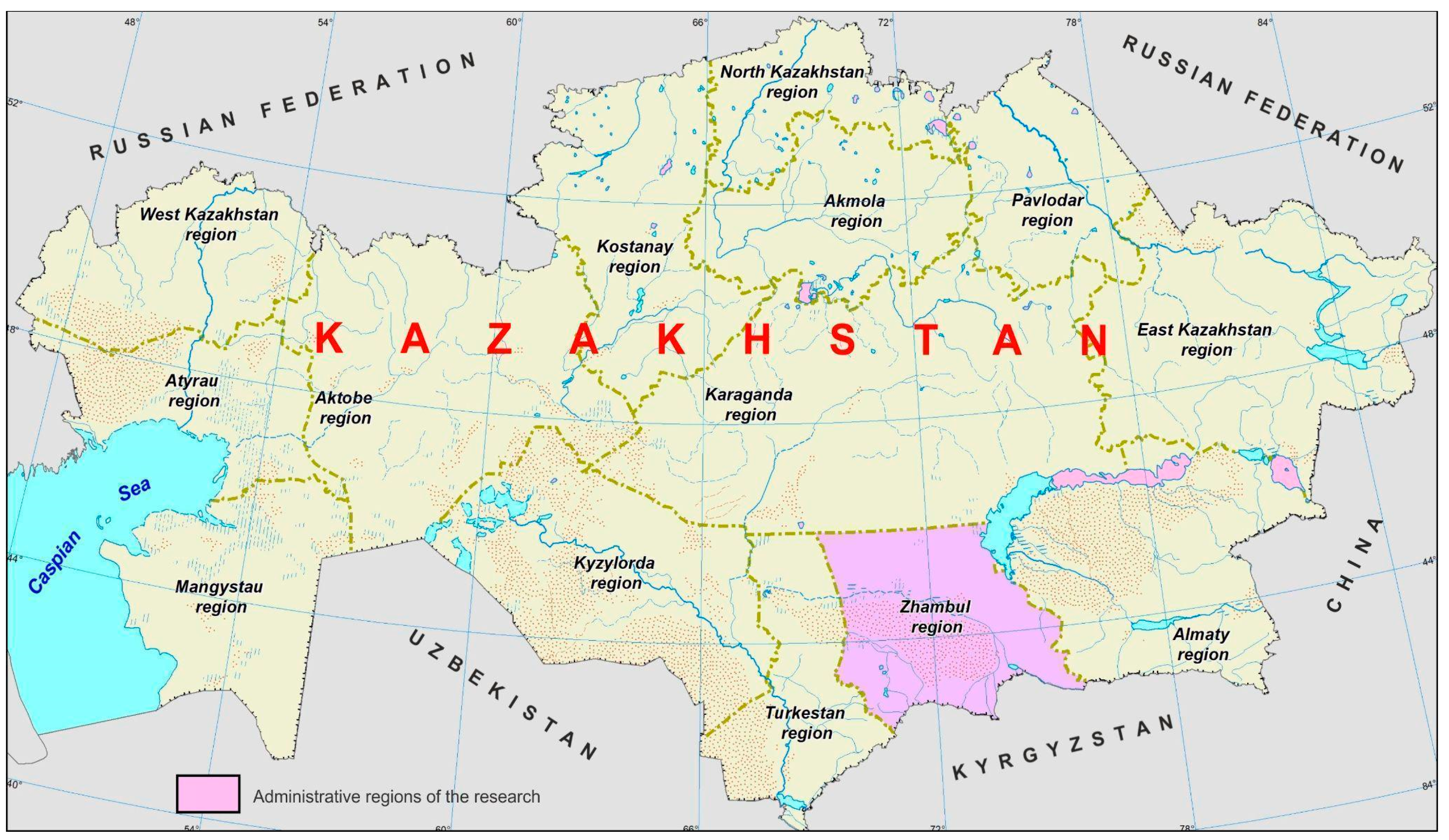
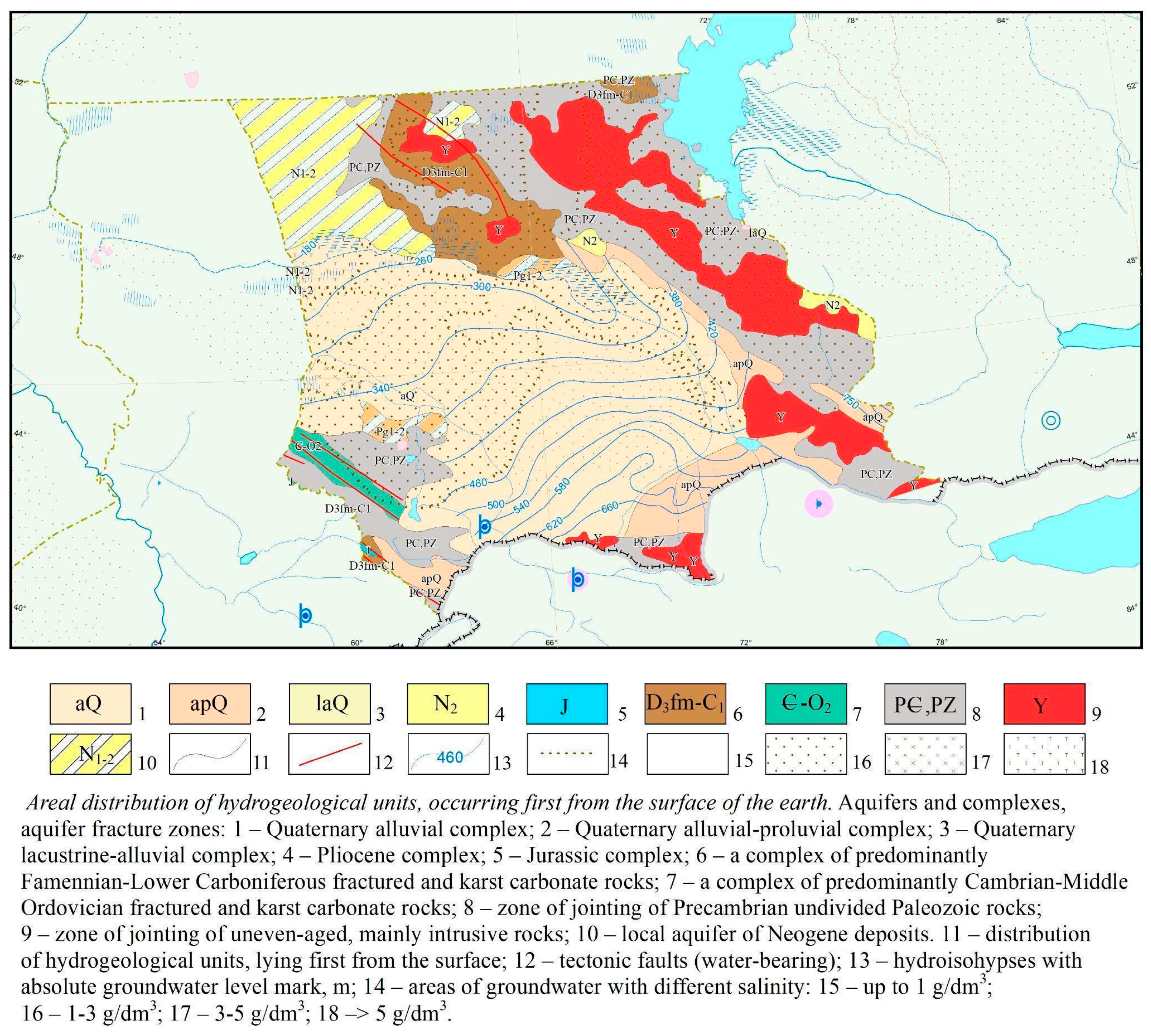
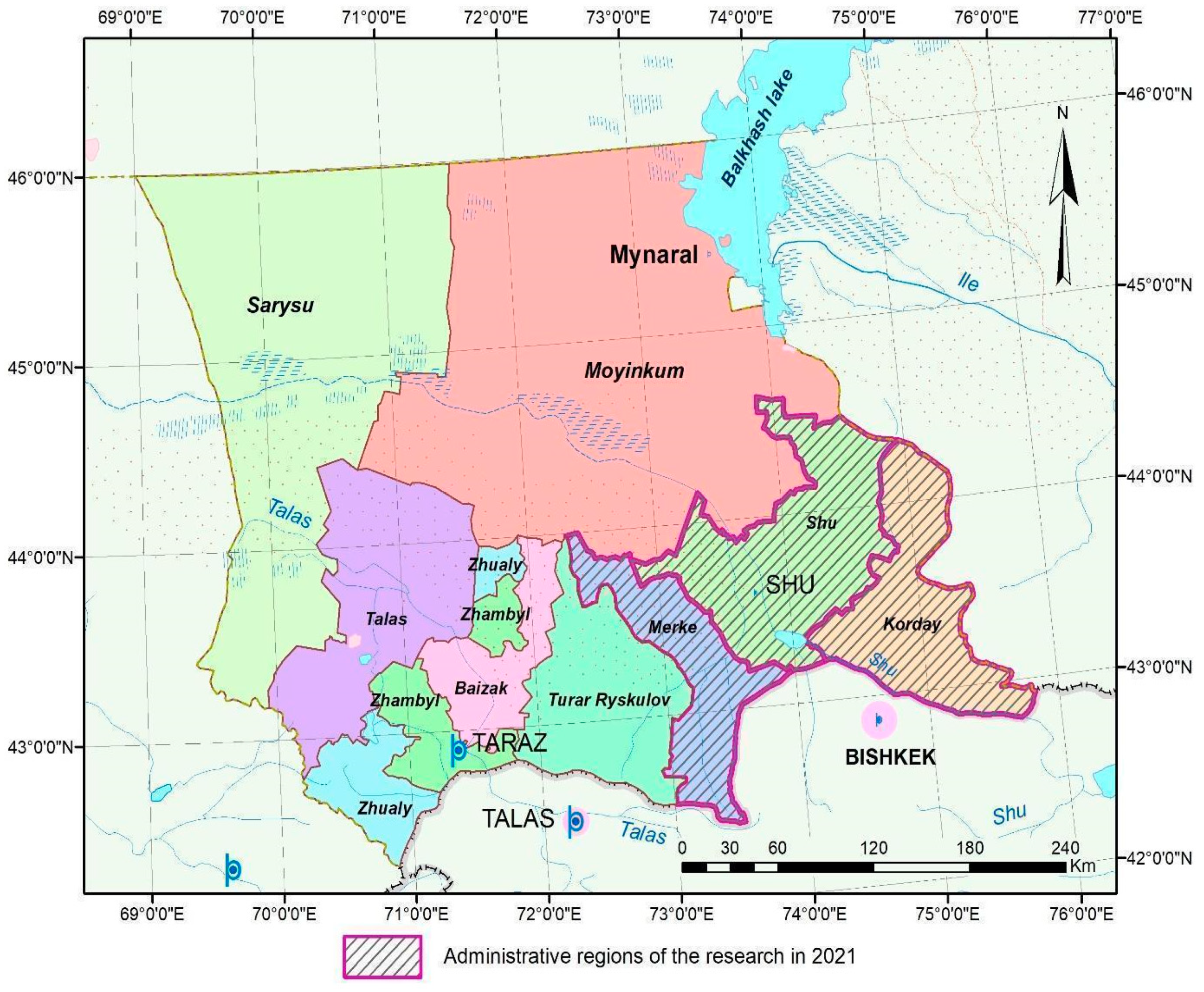
2.1. Study Area Description
- (I)
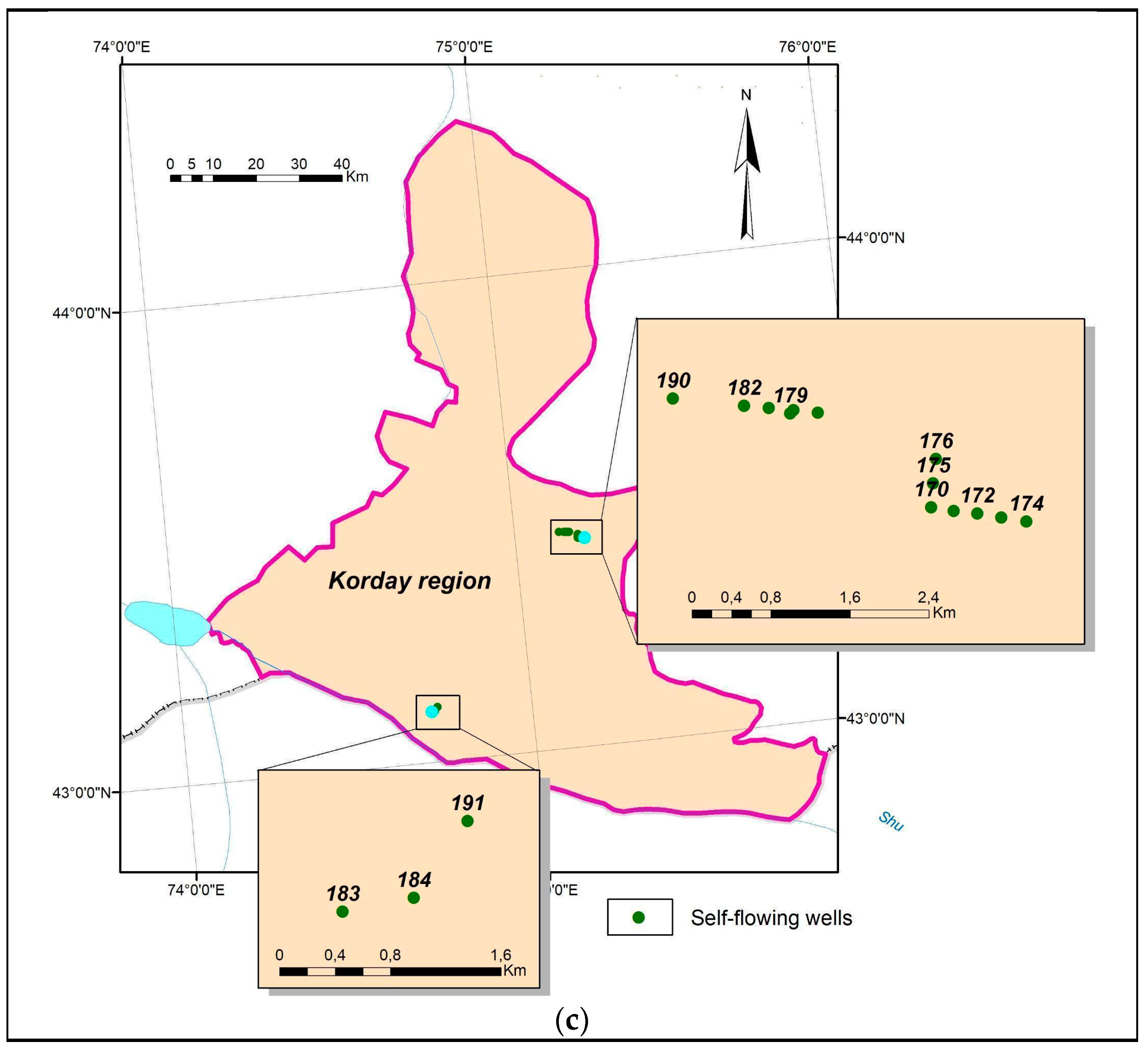
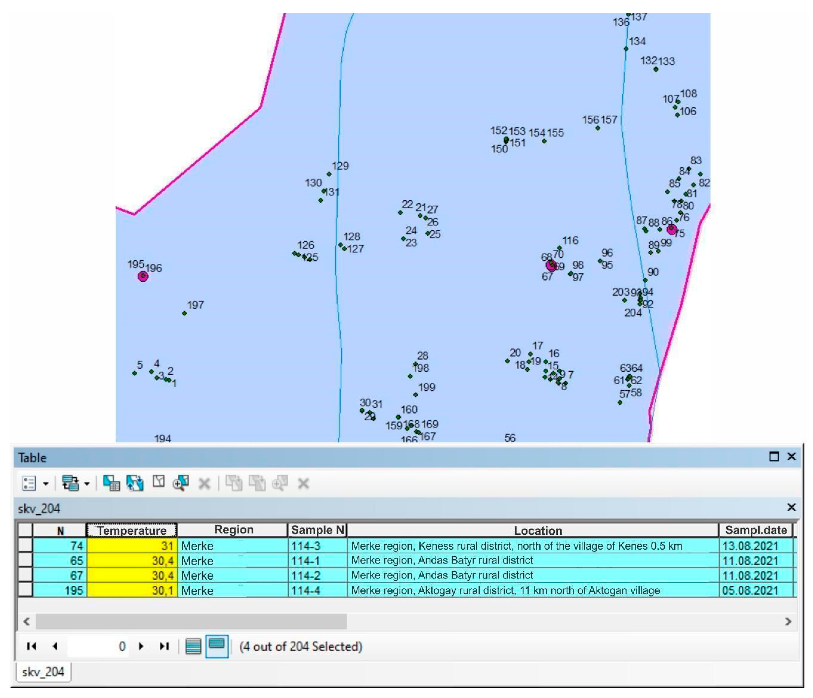
- The first phase lasting 30 days consisted of the fieldwork surveys of existing water wells in the Merke, Shu, and Korday districts in the Zhambyl region (Figure 2). The fieldwork surveys were concentrated on the inventory of wells, including
- -
- Wells coordinates, latitude, longitude, and elevation recording with Global Positioning System (GPS);
- -
- Wells flow rates measurements;
- -
- In situ parameters, temperature, pH, electrical conductivity (EC), and water tables were measured as MSL.
- (II)
- During the second phase, the field survey works were expanded:
- -
- More hydrogeological investigations were provided with measurements continuation of the wells flow rates, pH, temperature, and electrical conductivity;
- -
- Well water samples were collected for laboratory analyses.
- (III)
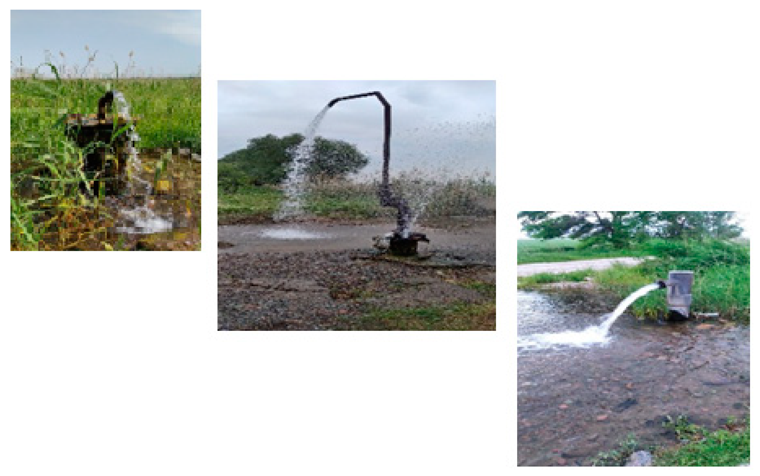
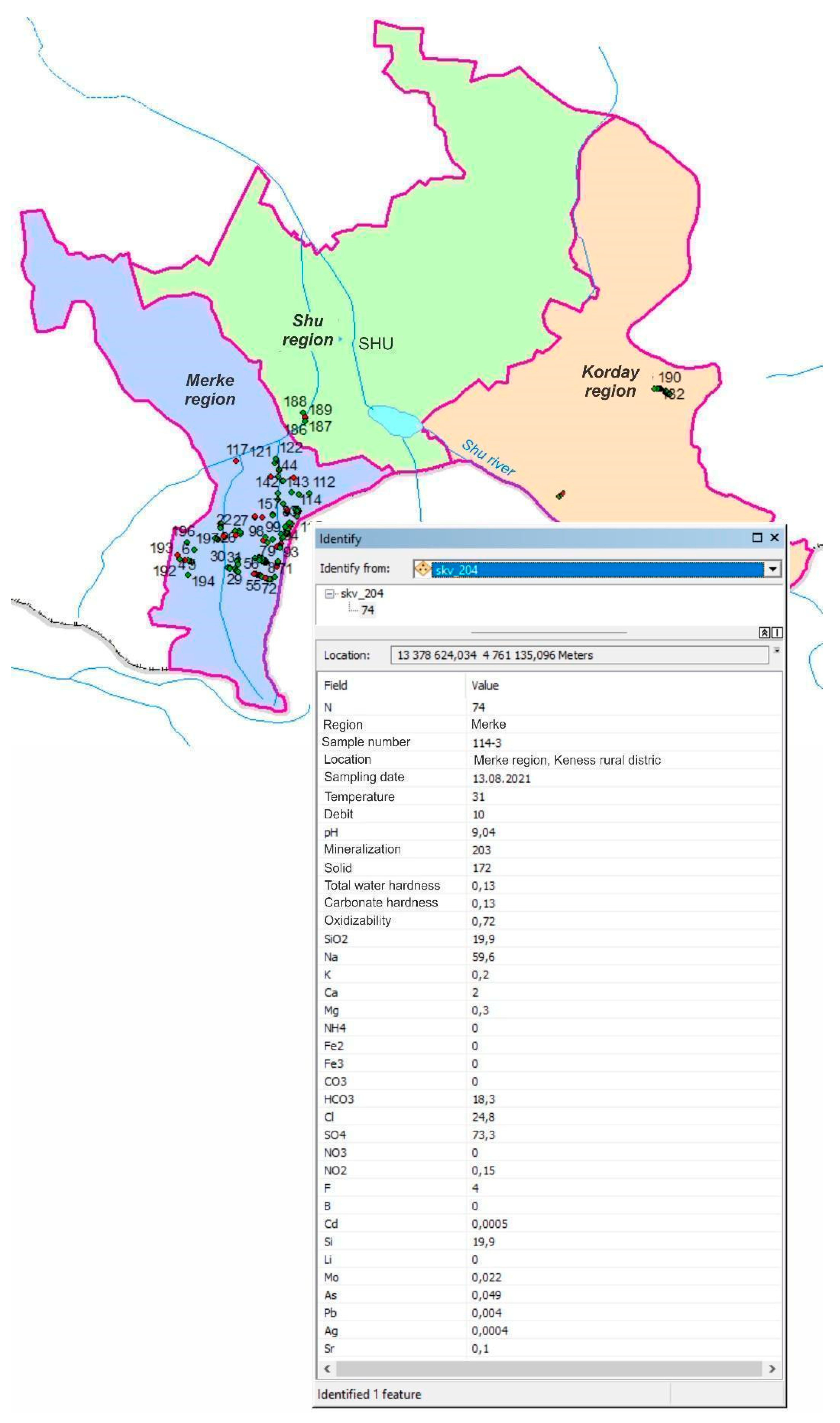
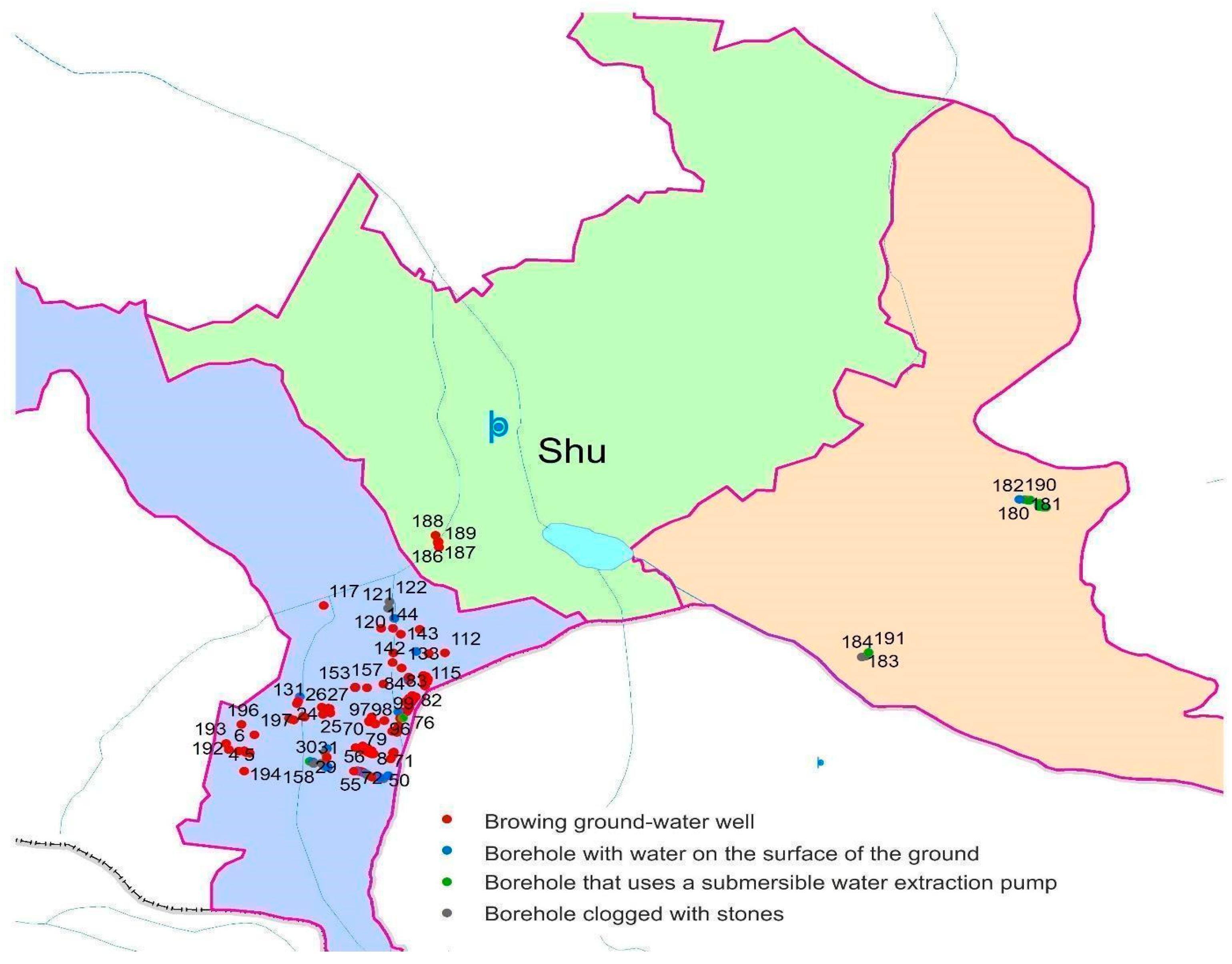
- During the third phase, the collected field data samples were processed and analyzed. During field surveys in the study area in Merke, Shu, and Korday districts of the Zhambyl region, several hundred hydrogeological wells were identified, of which more than half were artesian wells (Table 1, Figure 4). In most wells, groundwater was without the well-spring. Submersible pumps are installed in some wells. In a third of the wells, the wells are clogged with stones. Clogged wells need to be cleaned using an airlift method or new wells need to be drilled. The survey showed that 90% of artesian wells are within the Merke district in the Zhambyl region.
2.2. Sampling and Data Preparation
2.2.1. Laboratory Analysis
Alpha and Beta Activities Measurements
3. Results and Discussion
3.1. Groundwater Chemistry
3.2. Data and Database
4. Conclusions
Author Contributions
Funding
Data Availability Statement
Conflicts of Interest
References
- Farah Water Resources of Kazakhstan; Handbook; Galym: Almaty, Kazakhstan, 2002; p. 595. (In Russian)
- Jawadi, H.; Sagin, J.; Snow, D. A detailed assessment of groundwater quality in the Kabul basin, Afghanistan, and suitability for future development. Water 2020, 12, 2890. [Google Scholar] [CrossRef]
- UN. Available online: www.un.org/ru/global-issues/water (accessed on 15 September 2022).
- Yapiyev, V.; Sagintayev, Z.; Inglezakis, V.J.; Samarkhanov, K.; Verhoef, A. Essentials of Endorheic Basins and Lakes: A review in the context of current and future water resource management and mitigation activities in central Asia. Water 2017, 9, 798. [Google Scholar] [CrossRef] [Green Version]
- Salikova, N.; Rodrigo-Ilarri, J.; Alimova, K.; Rodrigo-Clavero, M.-E. Analysis of the water quality of the ishim river within the Akmola Region (Kazakhstan) using hydrochemical indicators. Water 2021, 13, 1243. [Google Scholar] [CrossRef]
- Sagin, J.; Adenova, D.; Tolepbayeva, A.; Poryadin, V. Underground water resources in Kazakhstan. Int. J. Environ. Stud. 2017, 74, 386–398. [Google Scholar] [CrossRef]
- Mirlas, V.; Makyzhanova, A.; Kulagin, V.; Kuldeev, E.; Anker, Y. An integrated aquifer management approach for the aridification-affected agricultural area, Shengeldy-Kazakhstan. Water 2021, 13, 2357. [Google Scholar] [CrossRef]
- Abdullaev, I.; Rakhmatullaev, S. Transformation of water management in Central Asia: From State-centric, a hydraulic mission to socio-political control. Environ. Earth Sci. 2013, 73, 849–861. [Google Scholar] [CrossRef]
- Hydrogeology of the USSR. South Kazakhstan. Moscow Subsoil 1970, 36, 473. (In Russian)
- Shahbazbegian, M.; Noori, R. Hydropolitical system archetypes: Feedback structures, physical environments, unintended behaviors, and a diagnostic checklist. Hydrology 2022, 9, 207. [Google Scholar] [CrossRef]
- Mukhamedjanov, M.A.; Arystanbaev, Y.Y. Underground waters of arid regions of Kazakhstan and their use under conditions of climate change and growth of water consumption. In Proceedings of the International Conference Water resources of Central Asia and their use, Almaty, Kazakhstan, 22–23 September 2016; Volume 1, pp. 122–126. (In Russian). [Google Scholar]
- Absametov, M.K.; Adenova, D.K.; Nusupova, A.B. Assessment of the impact of anthropogenic factors water resources of Kazakhstan. Ser. Geol. Tech. Sci. 2019, 1, 248–254. [Google Scholar] [CrossRef]
- Muratkhanov, D.; Rakhmetov, I.; Rakhimov, T. Recommendations on prevention, remediation, and mitigation of climate change negative effects on groundwater in Kazakhstan. In Proceedings of the 20th International Multidisciplinary Scientific Geo Conference & EXPO SGEM, Albena, Bulgaria, 18–24 August 2020; pp. 707–714. [Google Scholar] [CrossRef]
- Gogu, R.; Carabin, G.; Hallet, V.; Peters, V.; Dassargues, A. GIS-based hydrogeochemical databases, and groundwater modeling. Hydrogeol. J. 2001, 9, 555–569. [Google Scholar] [CrossRef]
- Guney, M.; Akimzhanova, Z.; Kumisbek, A.; Beisova, K.; Kismelyeva, S.; Satayeva, A.; Inglezakis, V.; Karaca, F. Mercury (Hg) contaminated sites in Kazakhstan: Review of current cases and site remediation responses. Int. J. Environ. Res. Public Health 2020, 17, 8936. [Google Scholar] [CrossRef]
- Noori, R.; Farahani, F.; Jun, C.; Aradpour, S.; Bateni, S.M.; Ghazban, F.; Hosseinzadeh, M.; Maghrebi, M.; Naseh, M.R.V.; Abolfathi, S. A non-threshold model to estimate carcinogenic risk of nitrate-nitrite in drinking water. J. Clean. Prod. 2022, 363, 132432. [Google Scholar] [CrossRef]
- Aradpour, S.; Noori, R.; Tang, Q.; Bhattarai, R.; Hooshyaripor, F.; Hosseinzadeh, M.; Haghighi, A.T.; Klöve, B. Metal contamination assessment in the water column and surface sediments of a warm monomictic man-made lake: Sabalan Dam Reservoir, Iran. Hydrol. Res. 2020, 51, 799–814. [Google Scholar] [CrossRef]
- Aradpour, S.; Noori, R.; Naseh, M.R.V.; Hosseinzadeh, M.; Safavi, S.; Ghahraman-Rozegar, F.; Maghrebi, M. Alarming carcinogenic and non-carcinogenic risk of heavy metals in Sabalan dam reservoir, Northwest of Iran. Environ. Pollut. Bioavailab. 2021, 33, 278–291. [Google Scholar] [CrossRef]
- Comunian, A.; Renard, P. Introducing wwhypda: A world-wide collaborative hydrogeological parameters database. Hydrogeol. J. 2008, 17, 481–489. [Google Scholar] [CrossRef] [Green Version]
- Ostrovsky, V.N. Groundwater Formation in Arid Areas of Kazakhstan; Sydykov, Zh.S., Sosedov, I.S., Eds.; Leningrad, USSR, Gidrometeoizdat: 1976; pp. 5–227. (In Russian). Available online: https://search.rsl.ru/ru/record/01006977637?ysclid=ld3g3vzfhu433384748 (accessed on 25 December 2022).
- Sydykov, Z.S.; Jakelov, A.K.; Jabasov, M.H. Underground Waters of Kazakhstan. Resources, Use and Protection Problems; Almaty, Kazakhstan, 1999; p. 11. Hardcopy monography (In Russian). Available online: https://reliefweb.int/report/kazakhstan/kazakhstan-killings-excessive-use-force-almaty (accessed on 25 December 2022).
- Medeu, A.R.; Malkovsky, I.M.; Toleubaeva, L.S.; Iskakov, N.A. Water Security of the REPUBLIC of Kazakhstan: Problems of Sustainable Water Supply; Almaty, Kazakhstan 2015; p. 582. (In Russian). Available online: https://ingeo.kz/?p=5127 (accessed on 25 December 2022).
- Republic of Kazakhstan Ministry of Investment and Development Committee for Roads. Environmental and Social Impact Assessment. 2015. Available online: https://www.ebrd.com/documents/environment/47229-esia-r.pdf (accessed on 25 December 2022).
- Dzhakelov, A.K. Formation of Groundwater of Chu-Sarysu Artesian Basin; Almaty, Kazakhstan. 1993, p. 240. (In Russian). Available online: https://search.rsl.ru/ru/record/01000594988?ysclid=ld3gpmwsw9702117854 (accessed on 25 December 2022).
- Smolyar, V.A.; Burov, B.V.; Mustafaev, S.T. Groundwater resources of the Republic of Kazakhstan. Water Resources of Kazakhstan: Assessment, Forecast, Management; Almaty, Kazakhstan. 2011, 8, p. 588. (In Russian).
- Veselov, V.V. Hydrogeological Zoning and Regional Assessment of Groundwater Resources of Kazakhstan: (Analysis of Research Results for 1961–2002), Almaty, Kazakhstan. 2002, p. 438. (In Russian). Available online: https://studwood.net/1288876/geografiya/spisok_ispolzovannyh_istochnikov?ysclid=ld3gwz0w9g195383365 (accessed on 25 December 2022).
- Murtazin, E.; Miroshnichenko, O.; Trushel, L. Description of the informational system of groundwater resources and reserves of Kazakhstan. In Proceedings of the 19th International Multidisciplinary Scientific Geo Conference & EXPO SGEM, Albena, Bulgaria, 30 June–6 July 2019; pp. 137–144. [Google Scholar]
- On Approval of the Rules for Sampling Moved (Transported) Objects and Biological Material. Available online: https:adilet.zan.kz/rus/docs/V1500011618 (accessed on 25 December 2022).
- Design and Operation of a Concentration Photoelectric Colorimeter (KFC-2). Available online: https:studfile.net/preview/4614227/page:8/ (accessed on 25 December 2022).
- Method for Determining the Total Specific Alpha Activity of Radionuclides. Available online: https:files.stroyinf.ru/Data2/1/4293785/4293785580.pdf?ysclid=lcrif05gt5205152543 (accessed on 25 December 2022).
- WHO/EU Drinking Water Standards Comparative Table. Available online: https://www.lenntech.com/who-eu-water-standards.htm (accessed on 10 September 2022).
- Murtazin, Y.; Adenova, D.; Tazhiyev, S. Assessment of the potential of self-discharging hydrogeological wells for sustainable development of rural areas of Zhambyl region. Ser. Geol. Tech. Sci. 2022, 5, 143–155. [Google Scholar] [CrossRef]
- Gumbatova, R.M. Effect of fluorine on the human body. Probl. Mod. Sci. Education. 2021, 2, 43–45. (In Russian) [Google Scholar]
- Chemical Properties Of Silicon, Health Effects Of Silicon, Environmental Effects of Silicon. Available online: https://www.lenntech.com/periodic/elements/si.htm#ixzz7mWr7NyYu (accessed on 12 May 2022).
- Terlikbayeva, A.; Hermosilla, S.; Galea, S.; Schluger, N.; Yegeubayeva, S.; Abildayev, T.; Muminov, T.; Akiyanova, F.; Bartkowiak, L.; Zhumadilov, Z.; et al. Tuberculosis in Kazakhstan: Analysis of risk determinants in national surveillance data. BMC Infect. Dis. 2012, 12, 262. [Google Scholar] [CrossRef] [Green Version]
- Maghrebi, M.; Noori, R.; Partani, S.; Araghi, A.; Barati, R.; Farnoush, H.; Haghighi, A.T. Iran’s Groundwater Hydrochemistry. Earth Space Sci. 2021, 8, e2021EA001793. [Google Scholar] [CrossRef]
- Walls, T.; Shingadia, D. The epidemiology of tuberculosis in Europe. Arch. Dis. Child. 2007, 92, 726–729. [Google Scholar] [CrossRef] [PubMed] [Green Version]
- WHO. Arsenic—World Health Organization. Fact Sheets. Available online: https://www.who.int/news-room/fact-sheets/detail/arsenic (accessed on 22 December 2022).
- Piper, A.M. A graphic procedure in the geochemical interpretation of water analyses. Eos Trans. Am. Geophys. Union 1944, 25, 914–928. [Google Scholar] [CrossRef]
- Kazakhstan Government. Drinking Water General Requirements for the Organization and Methods of Quality Control; ST RK GOST R 51232. In Proceedings of the Committee for Standardization, Metrology and Certification, Astana, Kazakhstan. 2003. (In Russian). Available online: https://waterservice.kz/downloads/rd/gst7.pdf?ysclid=ld3fpwacho899490449 (accessed on 22 December 2022).
- Order of the Chairman of the Committee for Water Resources of the Ministry of Agriculture of the Republic of Kazakhstan dated 9 November 2016 No. Registered with the Ministry of Justice of the Republic of Kazakhstan on 13 December 2016 No. 14513 Unified Classification System for Water Quality in Water Bodies. Available online: https://adilet.zan.kz/rus/docs/V070004735 (accessed on 12 May 2022).
- Li, X.; Wang, S.; Lou, H.; Pan, J.; Dong, Q.; Zheng, Y.; Chen, L. Simultaneous determination of gross alpha/beta activities in water by liquid scintillation counting and its applications in environmental monitoring. Sci. Rep. 2022, 12, 8281. [Google Scholar] [CrossRef]
- Bonotto, D.M. Gross alpha/beta radioactivity and radiation dose in thermal and non-thermal spas groundwaters. Heliyon 2019, 5, e01563. [Google Scholar] [CrossRef] [PubMed] [Green Version]
- Information and Analytical Review of Parliamentary Hearings on the Topic: Water Security of Kazakhstan: State, Problems, and Recommendations. Available online: https:senate.parlam.kz/storage/536c3d72c4494ae687e43510c22c78f1.pdf?ysclid=lcrjw39uy1260006563 (accessed on 25 December 2022).
- EPA. United States Environmental Protection Agency. Radiation Basics. Available online: https://www.epa.gov/radiation/radiation-basics (accessed on 7 May 2022).
- Radiation Health Basics. Available online: https://www.co.monmouth.nj.us/documents/118/RADIATION%20HEALTH%20BASICS.pdf (accessed on 10 May 2022).
- Gross Alpha Radiation, Uranium, and Radium in Drinking Water. Available online: https://www.healthvermont.gov/health-environment/drinking-water/radioactive-elements (accessed on 10 May 2022).
- Dzhumagulov, A.A.; Nikolaenko, A.Y.; Mirkhashimov, I.K.H. Water Quality Standards and Norms in the RK, Almaty. 2009, 44. Available online: https://carececo.org/publications/Standarty_i_nromy_kachestva_vod_v_Respublike_Kazakhstan.pdf (accessed on 5 October 2022).
- Non-Renewable Groundwater Resources. Foster, S.; and Loucks, D.P., Eds.; A Guidebook on Socially-Sustainable Management for Water-Policy Makers; IHP-VI, Series on Groundwater No. UNESCO. Paris, France. 2006, p. 97. Available online: https://www.un-igrac.org/sites/default/files/resources/files/GWMATE%20Books%20-%20Non-renewable%20grounwater%20resources.pdf (accessed on 5 October 2022).
- Fensham, R.; Laffineur, B. Response of spring wetlands to restored aquifer pressure in the Great Artesian Basin, Australia. J. Hydrol. 2022, 612, 128152. [Google Scholar] [CrossRef]
- Nurmadiyeva, G.T.; Zhetpisbaev, B.A. Impact of the ecosystem on human health in the industrially developed regions of Kazakhstan. Lit. Review. Sci. Health 2018, 4, 107–132. (In Russian) [Google Scholar]
- Nurmanova, Z.A. The issue of providing drinking water to the population of the regions of the Republic of Kazakhstan. Bull. KazNMU 2012, 1, 421–423. [Google Scholar]
- Toguzbayeva, K.K.; Myrzakhmetova, S.K.; Zhunistayev, D.D.; Niyazbekova, L.S.; Zhakhanov, A.Z.; Seiduanova, L.B.; Sailybekova, A.K.; Shayakhmetov, S.S.; Kaldybai, A.U.; Seitakhmetova, M.B.; et al. Hygienic assessment of the impact of the quality of household and drinking water supply on the health of the rural population of the Almaty region. Bull. KazNMU 2014, 3, 33–38. (In Russian) [Google Scholar]
- Pozdnyakova, A.P.; Taizhanova, D.Z.; Guseinova, Z.K.; Turemuratova, D.T.; Ashirbekov, G.K.; Adilgireyuly, Z. Screening of the health status of the population in the territories, approaching the district of the «Proton-m» accident in 2013, and in the comparison area—Aiteke bi. Med. Ecol. 2018, 1, 47–52. [Google Scholar]
- Healthcare in Kazakhstan: Problems and Solutions. Available online: https://borgenproject.org/tag/healthcare-in-kazakhstan/ (accessed on 10 September 2022).


| No. | Administrative Region | Total Inspected Well | With Well-Spring | Without Well-Spring | With Pump | Clogged by Stones |
|---|---|---|---|---|---|---|
| 1 | Merke | 182 | 132 | 22 | 5 | 23 |
| 2 | Shu | 5 | 5 | - | - | - |
| 3 | Korday | 17 | - | 1 | 14 | 2 |
| Total | 204 | 137 | 23 | 19 | 25 | |
| Well No. | Geographic Coordinates | Brief Description of Wells | Flow Rate, L/S | Photo of Wells | |
|---|---|---|---|---|---|
| Northern Latitude | East Longitude | ||||
| 2 | 42° 52′ 42.84″ | 73° 5′ 50.91″ | Spouting well is located opposite the Aktogan village. t of water in the well is 17.7 °C pH = 8.0 | 5 |  |
| 6 | 42° 53′ 4.37″ | 73° 2′ 44.06″ | Spouting well is located 5 km west of the Aktogan village. t of water in the well is 17.6 °C pH = 7.9 | 10 |  |
| 8 | 42° 52′ 53.00″ | 73° 25′ 16.09″ | Spouting well is located on the outskirts of the Makhanda village. t of water in the well is 11 °C pH = 8.4 | 15 |  |
| 9 | 42° 52′ 54.55″ | 73° 25′ 12.31″ | Spouting well is located at the entrance of Makhanda village. t of water in the well is 11.9 °C pH = 8.3 | 20 |  |
| 60 | 42° 53′ 3.10″ | 73° 28′ 40.30″ | Spouting well is located to the north of Kyzylkistak village, 1.2 km. t of water in the well is 15.0 °C pH = 8.6 | 25 |  |
| 22 | 42° 58′ 55.68″ | 73° 17′ 15.05″ | Spouting is located in the territory of Sypatay Batyr enterprise. t of water in the well is 17.8 °C pH = 8.5 | 30 |  |
| 136 | 43° 6′ 16.50″ | 73° 28′21.00″ | Wellbore clogged by rocks and foreign materials | - |  |
| 43 | 42° 50′2.50″ | 73° 24′42.80″ | Wellbore clogged by rocks and other materials | - |  |
| Parameter | Unit | Dry Season (November 2020) | Wet Season (April 2021) | Drinking Water Standards | |||||
|---|---|---|---|---|---|---|---|---|---|
| Min | Mean | Max | Min | Mean | Max | Kazakhstan | WHO/EU | ||
| pH | 7.5 | 8.0 | 8.9 | 8 | 8.6 | 9.29 | 6–9 | 6.2–8.5 | |
| Temp. | °C | 27 | 28.5 | 29.1 | 27.2 | 28.8 | 32 | ||
| Ca2+ | mg/L | 30 | 32 | 34 | 3.8 | 3.9 | 4 | ||
| Mg2+ | mg/L | 14.2 | 15 | 15.8 | 1 | 1.25 | 1.5 | ||
| Na+ | mg/L | 16.2 | 33.6 | 17.4 | 50.6 | 53.85 | 57.1 | 200 | |
| K+ | mg/L | 3.1 | 3.3 | 3.5 | 0.1 | 0.15 | 0.2 | ||
| HCO3− | mg/L | 170.5 | 176.8 | 183.1 | 15.2 | 16.75 | 18.3 | ||
| Cl− | mg/L | 6.9 | 7.0 | 7.1 | 20.2 | 20.75 | 21.3 | 350 | 250 |
| SO42− | mg/L | 20 | 21.5 | 23 | 53.2 | 54.6 | 56 | 500 | 250 |
| NO3− | mg/L | 15 | 15.2 | 15.4 | 1.4 | 1.45 | 1.5 | 45 | 50 |
| NO2 | mg/L | 0.01 | 0.015 | 0.02 | 0.01 | 0.01 | 0.01 | 0.50 | |
| SiO2 | mg/L | 4.0 | 4.4 | 4.8 | 20.2 | 20.8 | 21.4 | ||
| NH4+ | mg/L | 0.05 | 0.05 | 0.05 | 0.00 | 0.00 | 0.00 | 0.50 | |
| F | mg/L | 0.38 | 1,2 | 4.0 | 1.84 | 1.8 | 12.0 | 1.5 | 1.5 |
| B | mg/L | 0.00 | 0.00 | 0.00 | 0.00 | 0.00 | 0.00 | 0.5 | 1.0 |
| Si | mg/L | 2.2 | 3.5 | 4.81 | 19 | 20.2 | 21.4 | 10 | |
| Li | mg/L | 0.00 | 0.00 | 0.00 | 0.02 | 0.02 | 0.02 | 0.03 | |
| Mo | mg/L | 0.001 | 0.001 | 0.001 | 0.012 | 0.014 | 0.016 | 0.25 | |
| As | mg/L | 0.00 | 0.00 | 0.00 | 0.02 | 0.024 | 0.029 | 0.05 | 0.01 |
| Pb | mg/L | 0.002 | 0.002 | 0.002 | 0.004 | 0.0045 | 0.005 | 0.03 | 0.01 |
| Sr | mg/L | 0.00 | 0.00 | 0.00 | 0.10 | 0.2 | 0.3 | 7.0 | |
| Fe2 | mg/L | 0.1 | 0.1 | 0.1 | 0.00 | 0.00 | 0.00 | 0.3 | 0.2 |
| Fe3 | mg/L | 0.1 | 0.1 | 0.1 | 0.00 | 0.00 | 0.00 | 0.3 | 0.2 |
| No. | No. | Total Alpha Activity, Bq/L | Drinking Water Standards | Total Alpha Activity, Bq/L | Drinking Water Standards | ||
|---|---|---|---|---|---|---|---|
| Kazakhstan | WHO/EU | Kazakhstan | WHO/EU | ||||
| 1 | 65 | 0.19 | 0.1 | 0.1 | 0.7 | 1.0 | 1.0 |
| 2 | 67 | 0.15 | 0.1 | 0.1 | 0.6 | 1.0 | 1.0 |
| 3 | 74 | 0.09 | 0.1 | 0.1 | 0.12 | 1.0 | 1.0 |
| 4 | 195 | 0.18 | 0.1 | 0.1 | 0.14 | 1.0 | 1.0 |
| Ions | Unit | Min | Mean | Max | R2 | Interpretation |
|---|---|---|---|---|---|---|
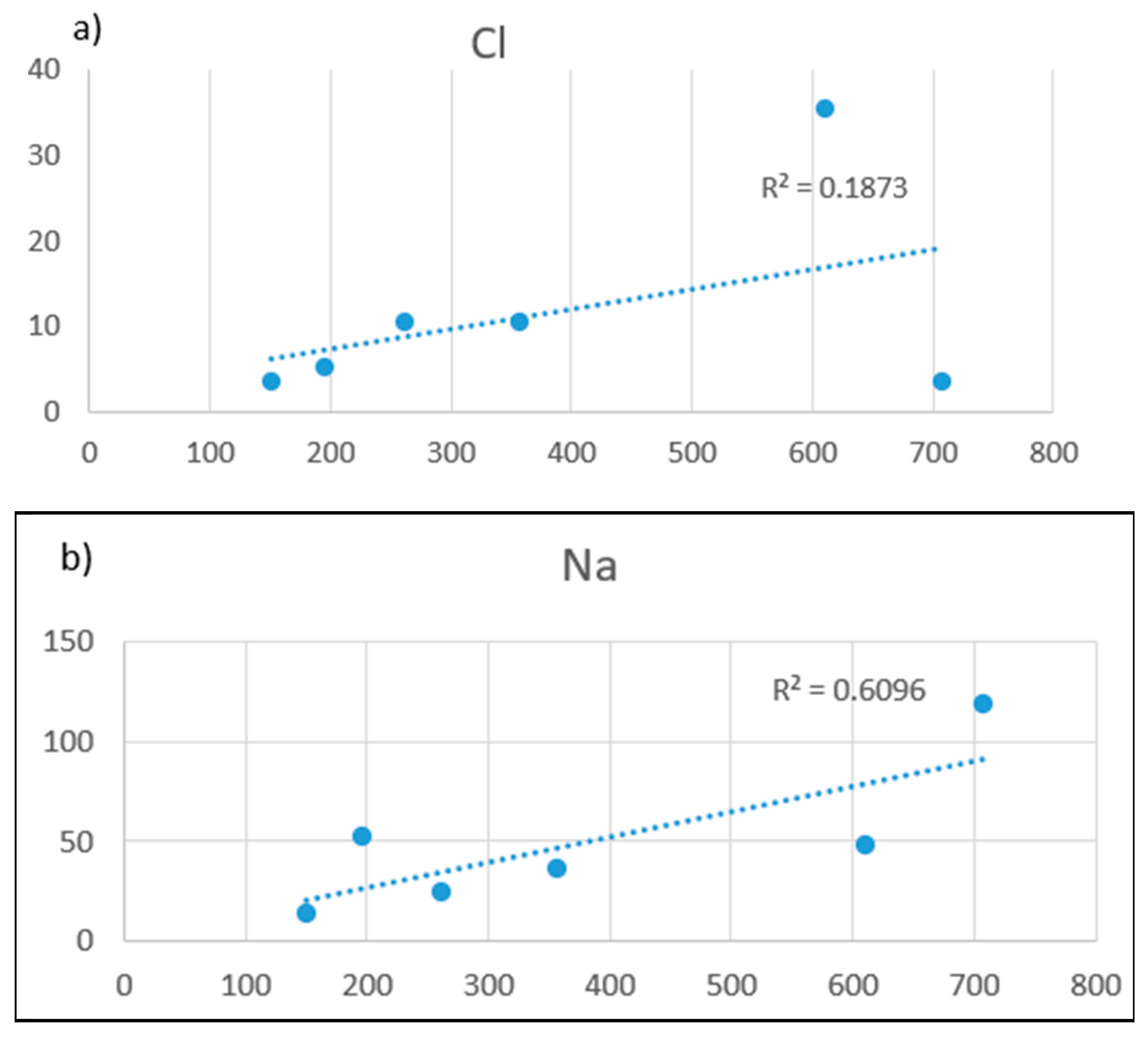
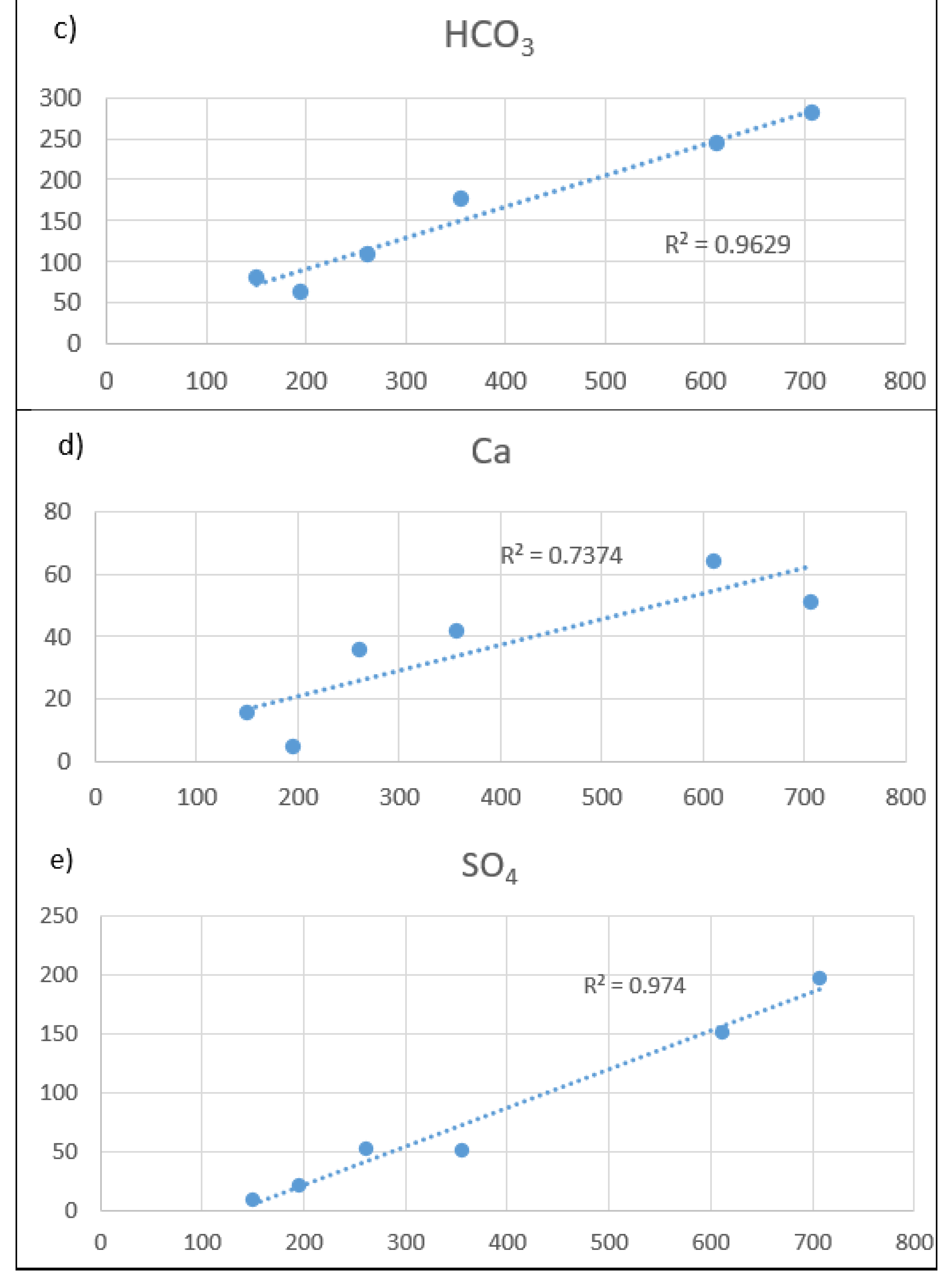
| Cl | mg/L | 6.9 | 10.2 | 21.3 | 0.1873 | Little if any correlation |
| Na | mg/L | 16.2 | 24.1 | 57.1 | 0.6096 | Moderate correlation |
| HCO3 | mg/L | 15.2 | 54.4 | 183.1 | 0.9629 | Very high correlation |
| Ca | mg/L | 3.8 | 16.2 | 34 | 0.7374 | High correlation |
| SO4 | mg/L | 21.5 | 28.6 | 56.0 | 0.974 | Very high correlation |
Disclaimer/Publisher’s Note: The statements, opinions and data contained in all publications are solely those of the individual author(s) and contributor(s) and not of MDPI and/or the editor(s). MDPI and/or the editor(s) disclaim responsibility for any injury to people or property resulting from any ideas, methods, instructions or products referred to in the content. |
© 2023 by the authors. Licensee MDPI, Basel, Switzerland. This article is an open access article distributed under the terms and conditions of the Creative Commons Attribution (CC BY) license (https://creativecommons.org/licenses/by/4.0/).
Share and Cite
Adenova, D.; Tazhiyev, S.; Sagin, J.; Absametov, M.; Murtazin, Y.; Trushel, L.; Miroshnichenko, O.; Zaryab, A. Groundwater Quality and Potential Health Risk in Zhambyl Region, Kazakhstan. Water 2023, 15, 482. https://doi.org/10.3390/w15030482
Adenova D, Tazhiyev S, Sagin J, Absametov M, Murtazin Y, Trushel L, Miroshnichenko O, Zaryab A. Groundwater Quality and Potential Health Risk in Zhambyl Region, Kazakhstan. Water. 2023; 15(3):482. https://doi.org/10.3390/w15030482
Chicago/Turabian StyleAdenova, Dinara, Sultan Tazhiyev, Janay Sagin, Malis Absametov, Yermek Murtazin, Ludmila Trushel, Oxana Miroshnichenko, and Abdulhalim Zaryab. 2023. "Groundwater Quality and Potential Health Risk in Zhambyl Region, Kazakhstan" Water 15, no. 3: 482. https://doi.org/10.3390/w15030482