
Concept and Implementation of Solutions Improving Water Relations in the Area of the Flooded Opencast Lignite Mine Kazimierz Północ in the East Wielkopolska Region (Central-West Poland)

Abstract
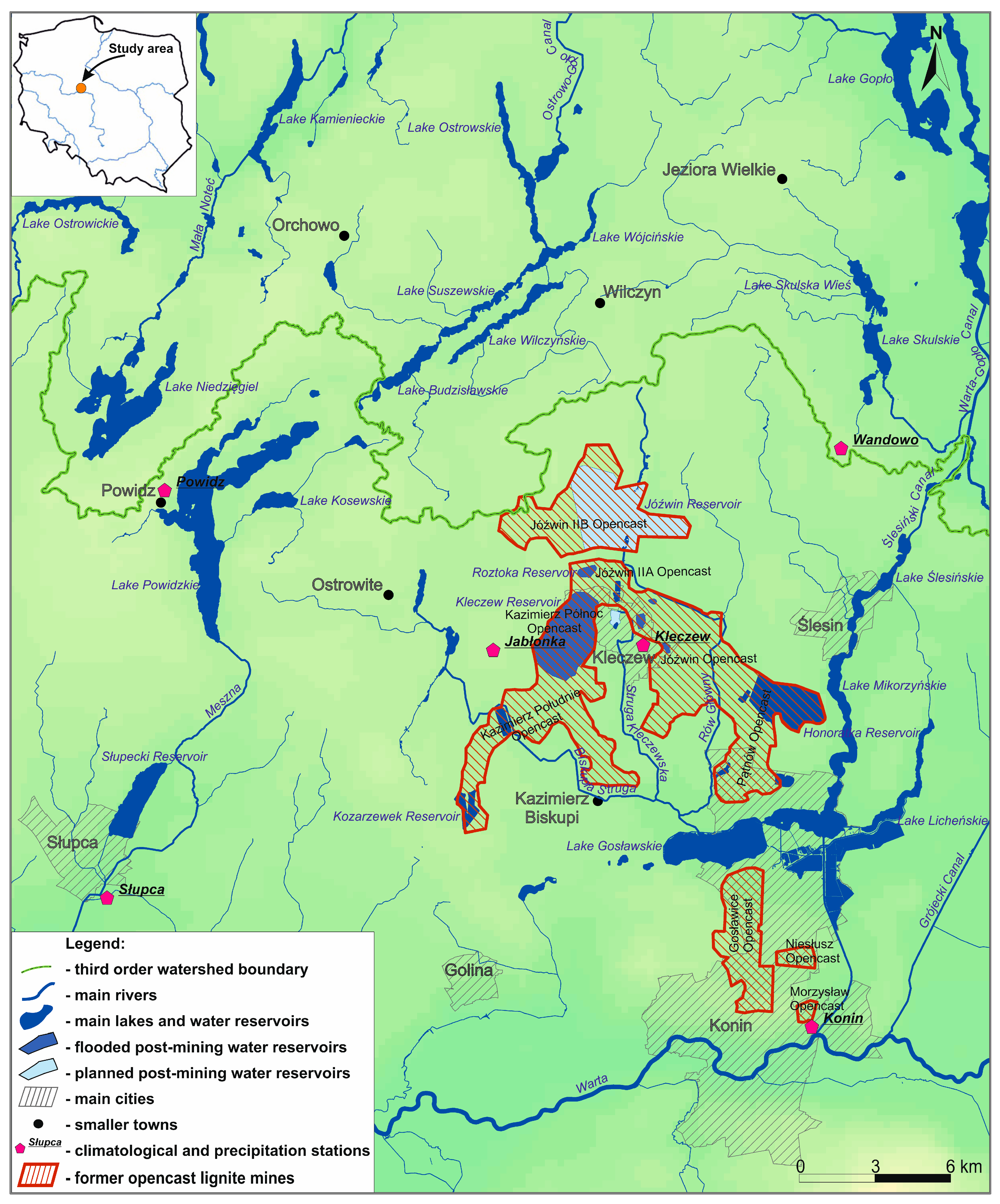
:1. Introduction
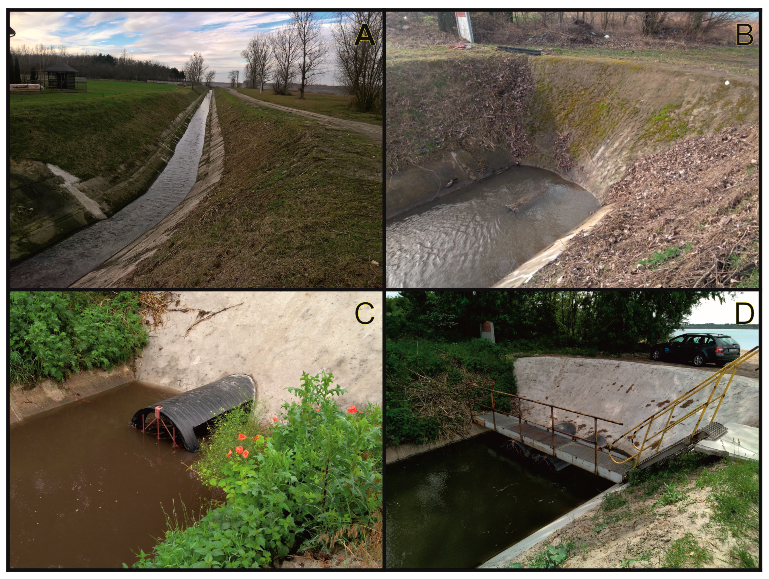
2. Materials and Methods
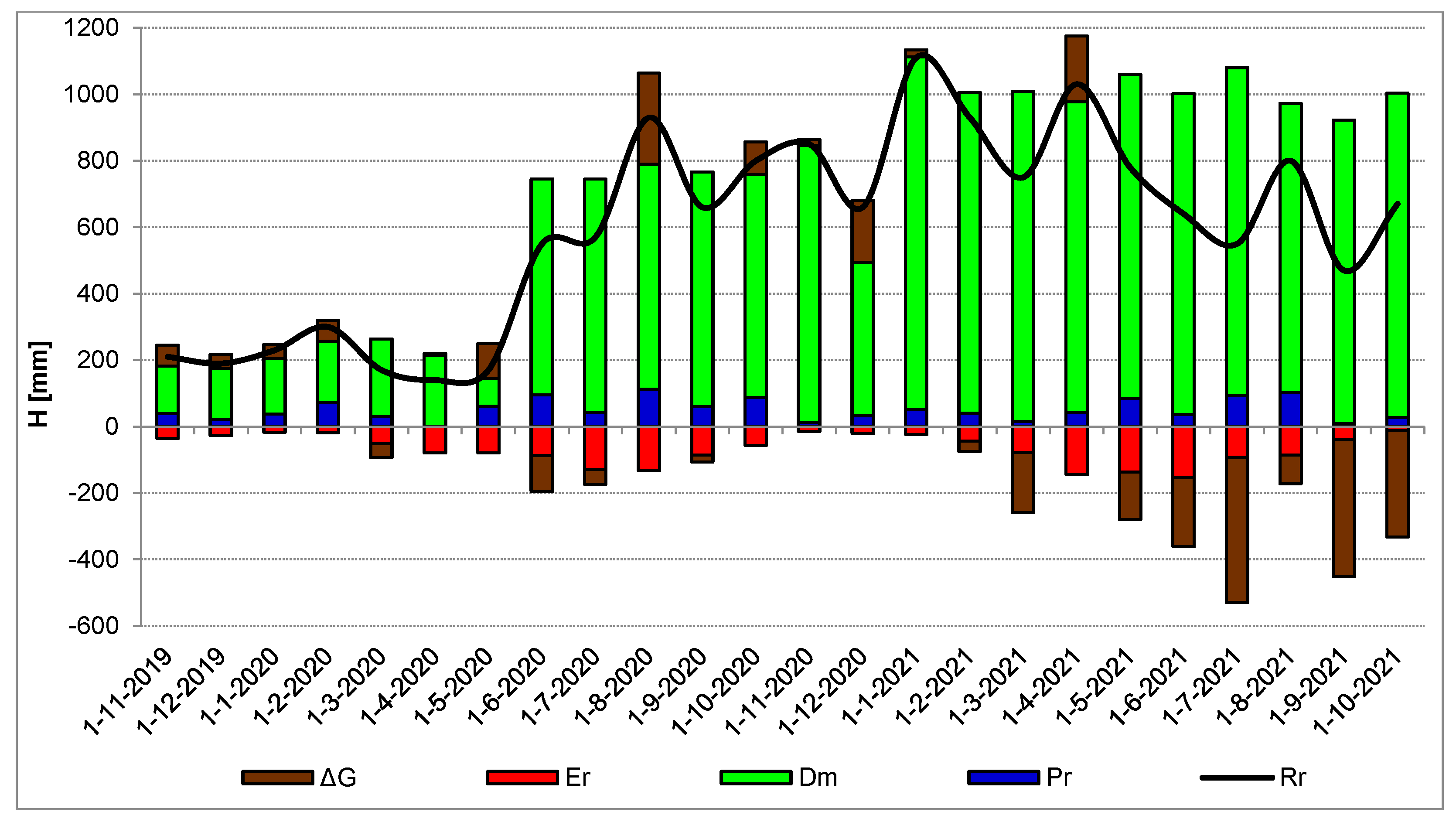
- Pr—precipitation on reservoir surface [mm; m3],
- Ir—river inflow [mm; m3],
- Is—surface inflow [mm; m3],
- Igr—groundwater inflow [mm; m3],
- Igd—groundwater inflow from deeper aquifers [mm; m3],
- Er—evaporation from reservoir surface [mm; m3],
- Or—river outflow [mm; m3],
- Ogr—groundwater outflow [mm; m3],
- Ogd—groundwater outflow towards deeper aquifers [mm; m3],
- ∆Rr—reservoir retention during the balance period [mm; m3].
- Pr—precipitation on reservoir surface [mm; m3],
- Er—evaporation from reservoir surface [mm; m3],
- Dm—discharge of mine waters [mm; m3],
- ∆G—resultant of groundwater inflow and outflow [mm; m3],
- ∆Rr—retention of the reservoir during the balance period [mm; m3].
- E—monthly evaporation amount [mm],
- t—mean monthly air temperature in a meteorological cage at a height of 2 m above ground level [°C],
- f—mean monthly relative air humidity [%]
- E0—daily evaporation amount [mm],
- u2—mean daily wind speed at a height of 2 m above ground level [m/s],
- e0j—mean daily saturated water vapour pressure at surface temperature in the reservoir [hPa],
- e—mean daily water vapour pressure in the air in a meteorological cage at a height of 2 m above ground level [hPa].
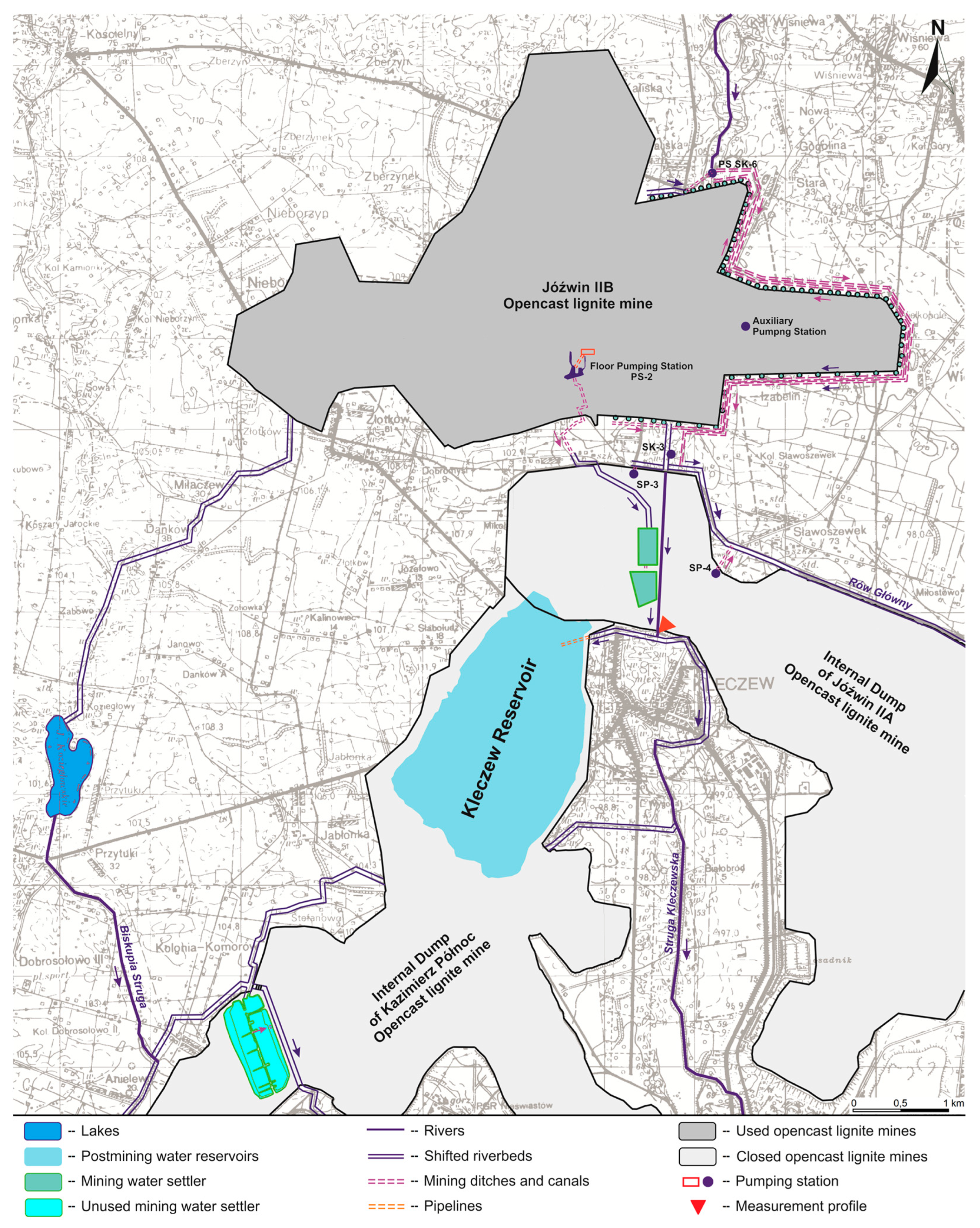
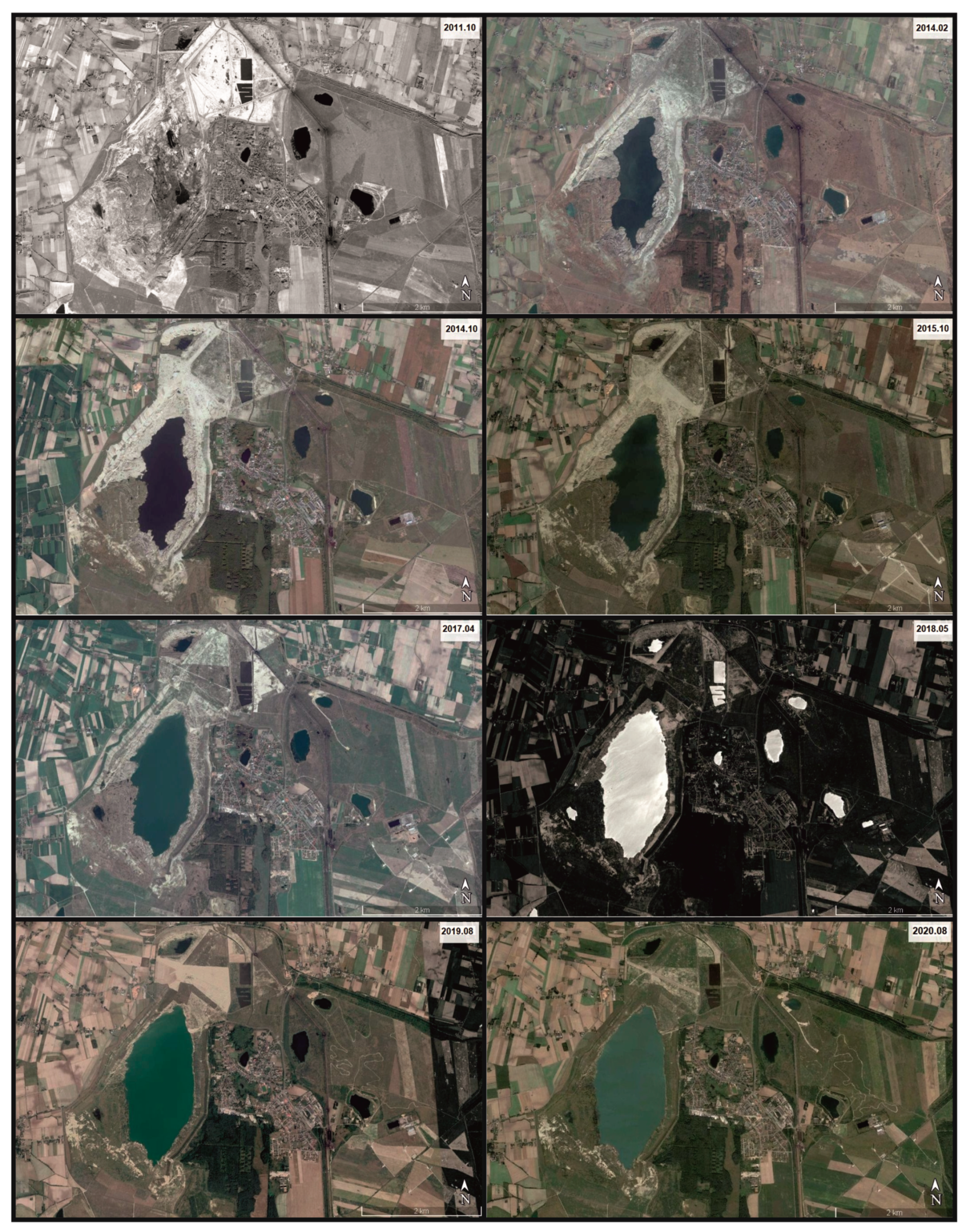
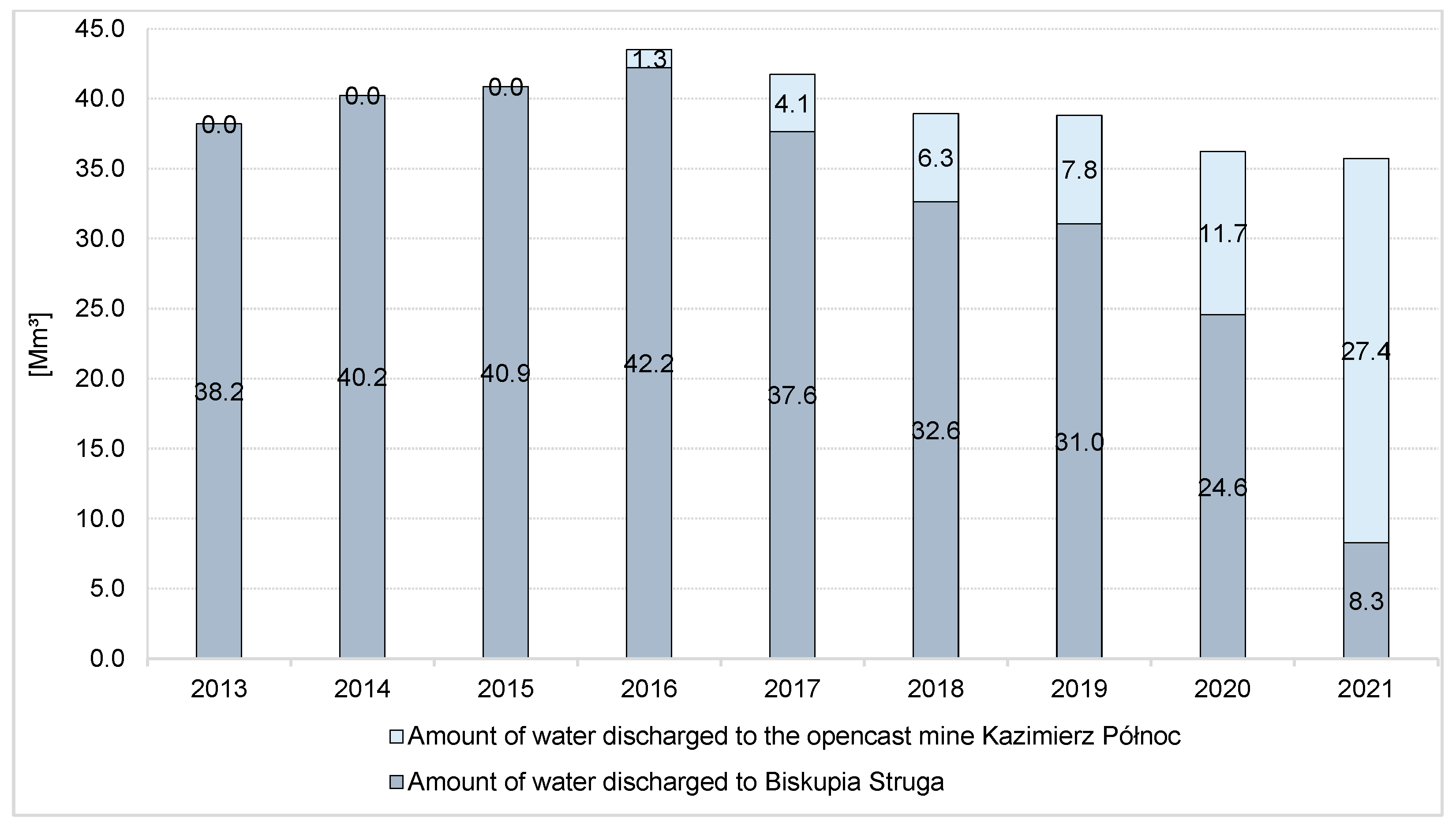
3. Results
- Φ = 1000 mm over a section of 25 m, further transitioning into pipeline Φ = 900 mm until the water surface of the reservoir,
- Φ = 900 mm until the water level in the reservoir.
4. Discussion
5. Conclusions
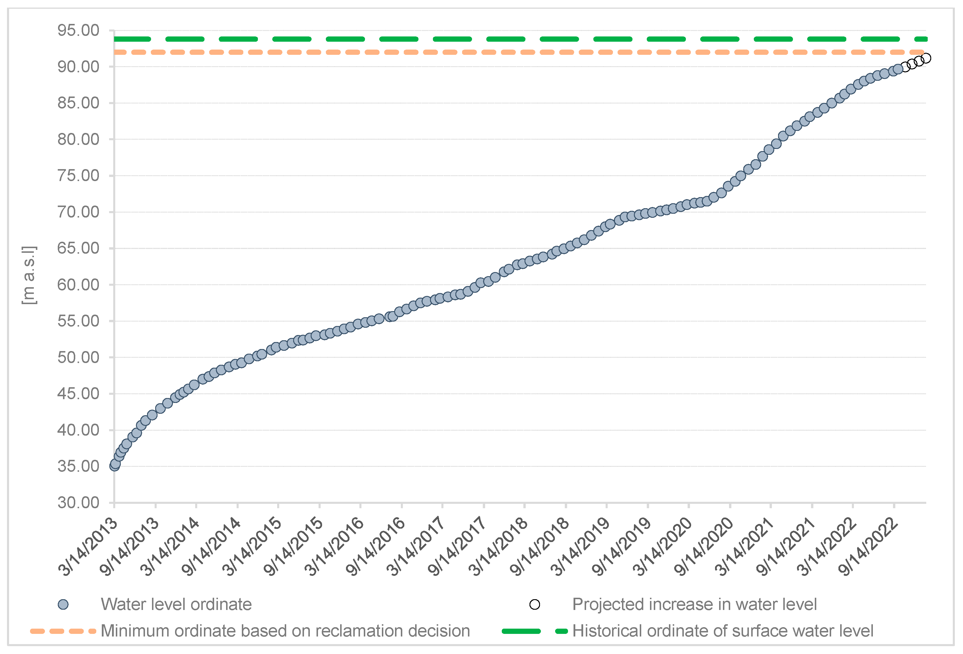
- Remodelling of the system of drainage of the opencast mine Jóźwin IIB and redirecting the majority of mine water to the post-mining water reservoir Kazimierz Północ in 2020 contributed to a considerable acceleration of flooding of the reservoir.
- The maintenance of the rate of increase in the water level in the post-mining water reservoir Kazimierz Północ suggests that it will be completely filled in the third quarter of 2023, and not, as originally assumed, around 2030.
- The emerging reservoir increasingly shows seasonal variability in the groundwater supply, depending on the precipitation amount and evaporation, as well as an increase in the share of groundwater drainage towards the nearby opencast lignite mine Jóźwin IIB.
- Faster filling of the post-mining water reservoir Kazimierz Północ will contribute to the improvement of hydrological relations in the area, particularly in areas located to the west.
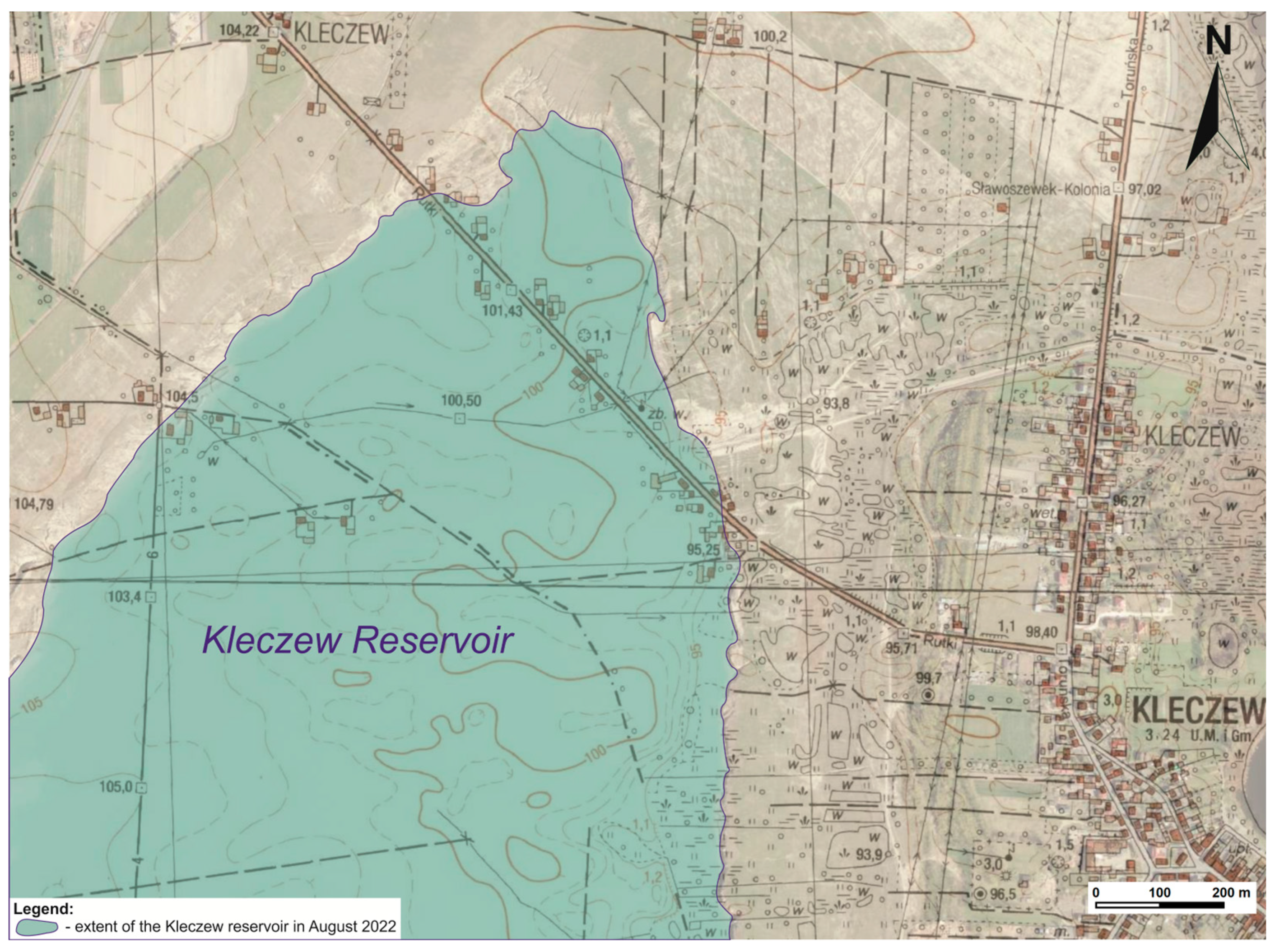
- The new Kleczew reservoir, with a volume of 150 Mm3, will improve the state of water resources in Wielkopolska, provide conditions for the development of valuable and rare plants and animals, and permit tourist development in the post-mining areas.
Author Contributions
Funding
Data Availability Statement
Acknowledgments
Conflicts of Interest
References
- Ilnicki, P. Wpływ drenażu odkrywek węgla brunatnego na walory rekreacyjne Pojezierza Gnieźnieńskiego (The impact of lignite opencast drainage on the recreational values of the Gnieźnieńskie Lakeland). Aura 1996, 11, 10–12. [Google Scholar]
- Ilnicki, P. Ratowanie jezior Powidzkiego Parku Krajobrazowego (Rescue of the lakes of the Powidzki Landscape Park). Biul. Park. Kraj. Wielkop. 2008, 14, 48–65. [Google Scholar]
- Nowak, B.; Przybyłek, J. Recharge and drainage of lakes in Powidzki Landscape Park in the conditions of increased anthropogenic and environmental pressure (Central-Western Poland). Geol. Quart. 2020, 64, 205–219. [Google Scholar] [CrossRef]
- Marszelewski, W.; Radomski, B. Quantitative degradation of water resources of the lakes in the eastern part of the Gniezno Lakeland. In Anthropogenic and Natural Transformations of Lakes; Bajkiewicz-Grabowska, E., Borowiak, D., Eds.; Polish Limnological Society: Gdańsk, Poland, 2008; Volume 2, pp. 119–122. [Google Scholar]
- Sawicki, J. Zmiany Naturalnej Infiltracji Opadów Do Warstw Wodonośnych Pod Wpływem Głębokiego, Górniczego Drenażu (Changes in Natural Precipitation Infiltration into Aquifers under the Influence of Deep Mining Drainage); Oficyna Wydawnicza Politechniki Wrocławskiej: Wrocław, Poland, 2000; pp. 1–174. [Google Scholar]
- Fiszer, J.; Dąbrowski, S.; Orion-Jędrysek, M.; Derkowska-Sitarz, M.; Straburzuńska-Janiszewska, M.; Rynarzewski, W.; Zachaś, J.; Matusiak, M.; Janiszewska, B.; Pawlak, A. Numeryczny Model Hydrogeologiczny dla KWB Konin w Zasięgu Oddziaływania Systemu Odwadniania Wraz z Bilansem Wodnogospodarczym (Numerical Hydrogeological Model for the Konin Lignite Mine within the Impact of the Drainage System along with the Water and Economic Balance); Archiwum Instytutu Górnictwa Politechniki Wrocławskiej: Wrocław, Poland, 2009; pp. 1–73. [Google Scholar]
- Fiszer, J.; Derkowska-Sitarz, M. Prognoza rozwoju leja depresji i dopływów do Kopalni Węgla Brunatnego Konin z uwzględnieniem projektowanych odkrywek Tomisławice i Ościsłowo (Forecast of development of depression cone and water inflows to brown coal mine Konin including designed open pits Tomisławice and Ościsłowo). Biul. Panstw. Inst. Geol. 2010, 442, 37–42. [Google Scholar]
- Dąbrowski, S.; Rynarzewski, W.; Straburzyńska-Janiszewska, R.; Zachaś, J.; Pawlak, A. Zasoby wód podziemnych systemu wodonośnego wschodniej części Pojezierza Wielkopolskiego (The groundwater resources of hydrogeological system in the Eastern Wielkopolska Lake Region). Biul. Panstw. Inst. Geol. 2011, 445, 75–85. [Google Scholar]
- Piasecki, A.; Marszelewski, W. Krótkookresowe Zmiany Zasobów Wodnych Jezior w Zlewni Kanału Ostrowo-Gopło (Short-Term Changes in Water Resources of Lakes in the Catchment Area of the Ostrowo-Gopło Canal); Wydawnictwo Bezkresy Wiedzy: Saarbrücken, Germany, 2013; pp. 1–112. [Google Scholar]
- Ilnicki, P.; Orłowski, W. Rezygnacja z retencjonowania wody na wododziale Noteci i Warty sprzeczna z zasadą zrównoważonego rozwoju (Resignation from water retention in the Noteć and Warta watersheds contrary to the principle of sustainable development). Gosp. Wod. 2011, 8, 322–328. [Google Scholar]
- Orłowski, W.; Ilnicki, P. Problemy gospodarowania wodą w otoczeniu Kopalni Węgla Brunatnego Konin (Water management problems in the vicinity of the Konin Brown Coal Mine). Gosp. Wod. 2007, 9, 383–386. [Google Scholar]
- Przybyłek, J. Środowiskowe uwarunkowania skutków eksploatacji odkrywkowej węgla brunatnego na Pojezierzu Gnieźnieńskim (Environmental conditions of the effects of opencast brown coal exploitation in the Gniezno Lakeland). Prz. Geol. 2020, 68, 645–654. [Google Scholar] [CrossRef]
- Przybyłek, J. Aktualne problemy odwadniania złóź węgla brunatnego w Wielkopolsce (Current problems of the lignite open cast mines dewatering in the Wielkopolska Region). Górn. Odkr. 2018, 2, 5–14. [Google Scholar]
- Przybyłek, J.; Nowak, B. Wpływ niżówek hydrogeologicznych i odwodnień górniczych na systemy wodonośne Pojezierza Gnieźnieńskiego (Impact of hydrogeological low flows and groundwater drainage by lignite open cast mine on aquifer systems in Gniezno Lakeland). Biul. Panstw. Inst. Geol. 2011, 445, 513–528. [Google Scholar]
- Ilnicki, P.; Orłowski, W. Klęska ekologiczna w Powidzkim Parku Krajobrazowym (Ecological disaster in the Powidzki Landscape Park). Aura 2006, 10, 11–14. [Google Scholar]
- Nowak, B.; Ptak, M. Natural and anthropogenic conditions of water level fluctuations in lakes—Lake Powidzkie case study (Central-Western Poland). J. Water Land Dev. 2019, 40, 13–25. [Google Scholar] [CrossRef]
- Nowak, B. Znikające jeziora (The disappeared lakes). Gaz. Obs. IMGW Obs. 2019, 1, 22–25. [Google Scholar]
- Nowak, B.; Lawniczak-Malinska, A.E. The influence of hydrometeorological conditions on changes in littoral and riparian vegetation of a meromictic lake in the last half-century. Water 2019, 11, 2651. [Google Scholar] [CrossRef]
- Nowak, B. Rola Jezior w Kształtowaniu Zasilania i Drenażu wód Podziemnych na Pojezierzu Gnieźnieńskim w Warunkach Naturalnych i Antropopresji Hydrodynamicznej (The Role of Lakes in Drainage and Recharge of Groundwater in the Gniezno Lakeland Area in Natural Conditions and Conditions of Hydrodynamic Anthropopressure). Ph.D. Thesis, Adam Mickiewicz University in Poznan, Poznan, Poland, 2018; pp. 1–198. [Google Scholar]
- Nowak, B.; Władczyk, J. Działania Wód Polskich poprawiających retencję na Pojezierzu Wielkopolsko-Kujawskim (Water retention activities carried out by the Polish Waters National Water Management Holding on the territory of the Wielkopolska-Kujawy Lake District). Gosp. Wod. 2022, 2, 12–19. [Google Scholar] [CrossRef]
- Nowak, B.; Nadolna, A.; Stanek, P. Evaluation of the potential for the use of lakes in restoring water resources and flood protection, with the example of the Noteć Zachodnia River catchment (Gniezno Lakeland, Poland). Met. Hydr. and Wat. Man. 2018, 6, 45–58. [Google Scholar] [CrossRef]
- Water law permit—By the authority of Marshal of the Wielkopolskie Voivodeship as of 27 April 2016 ref. DSR-II-1.7322.76.2015 regarding extraordinary use of waters, namely damming on a culvert on 8+883 km of Struga Kleczewska, damming on a culvert on 3+31 km of the mining canal, and water transfer from Struga Kleczewska through a mining ditch to the designed water body in the excavation pit of the liquidated opencast lignite mine Kazimierz Północ.
- Water law permit—By the authority of the Director of the Regional Water Management Authority in Poznań as of 25 May 2021 ref. PO.RUZ.4210.8.2021.OB.8 regarding water service in the scope of damming of surface waters of Struga Kleczewska by means of a culvert 2×Φ888+Φ1500 on 8+883 km of the stream, equipped with valves with a stoplog gate, and exceptional use of waters covering transport of surface waters from Struga Kleczewska to the designated reservoir in the liquidated opencast lignite mine Kazimierz Północ.
- Przybyłek, J.; Gąbka, M.; Kamiński, W.; Wiliński, R. Analiza Możliwości Zasilania Jezior Powidzkiego Parku Krajobrazowego Zasobami Wodnymi Rzeki Warty Oraz Szczytowego Stanowiska Kanału Ślesińskiego (Analysis of the Possibility of Supplying the Lakes of the Powidzki Landscape Park with Water Resources of the Warta River and the Top Position of the Ślesiński Canal); Wielkopolskie Biuro Planowania Przestrzennego: Poznań, Poland, 2020; pp. 1–150. [Google Scholar]
- Przybyłek, J. Stan i możliwości odbudowy stosunków wodnych na Pojezierzu Gnieźnieńskim po zakończeniu odkrywkowej eksploatacji węgla brunatnego (The status and possibilities of rebuilding water relations in the Gniezno Lake District after the end of the open-pit mining of lignite). In Wybrane Zagdnienia Hydrogeologiczne Oraz Różne Aspekty Związane z Eksploatacją Wód Podziemnych (Selected Hydrogeological Issues and Various Aspects Related to the Exploitation of Groundwater); Krogulec, E., Ed.; PZiTS Oddział Częstochowa: Częstochowa, Poland, 2021; pp. 11–25. [Google Scholar]
- Kondracki, J. Geografia regionalna Polski (Regional geography of Poland); Wydawnictwo Naukowe PWN: Warszawa, Poland, 2009; pp. 1–441. [Google Scholar]
- Kędziora, A. Warunki klimatyczne i bilans wodny Pojezierza Kujawskiego (Climatic conditions and water balance of the Kujawy Lakeland). Rocz. Glebozn. 2011, 62, 189–203. [Google Scholar]
- Kędziora, A. Bilans wodny krajobrazu konińskich kopalni odkrywkowych w zmieniających się warunkach klimatycznych (Water balance of Konin strip mine landscape in changing climatic conditions). Rocz. Glebozn. 2008, 59, 104–118. [Google Scholar]
- Nowak, B. Reżim Hydrologiczny JEZIORA Powidzkiego i Jego Znaczenie w Lokalnych Systemach Wodonośnych (The Hydrological Regime of Powidzkie Lake and Its Importance in Local Aquifers. In Jezioro Powidzkie wczoraj i Dziś (Powidzkie Lake Yesterday and Tomorrow); Nowak, B., Ed.; IMGW-PIB: Warszawa, Poland, 2019; pp. 37–50. [Google Scholar]
- Farat, R. Atlas Klimatu Województwa Wielkopolskiego (Climate Atlas of the Greater Poland Voivodeship); Wydawnictwo IMGW: Poznań, Poland, 2004; pp. 1–140. [Google Scholar]
- IMGW. Roczniki Hydrologiczno-Meteorologiczne KWB Konin (Hydrological and Meteorological Yearbooks of PAK KWB Konin); IMGW: Poznań, Poland, 1995–2020. [Google Scholar]
- Oppokov, E.V. Mnogoletnie kolebania stoka na bolshikh rechnykh basseinakh v sviazi s kolebaniami meteorologicheskikh elementov (Long-term variations of strem-flow of large river basins in connexion with the variations of meteorological elements). Zhurnal Minist. Putei Soobschenia. 1906, 7–8. [Google Scholar]
- Bajkiewicz-Grabowska, E. Obieg Materii w Systemach Rzeczno-Jeziornych (Circulation of Matter in River-Lake Systems); Uniwersytet Warszawski Wydział Geografii i Studiów Regionalnych: Warszawa, Poland, 2002; pp. 1–274. [Google Scholar]
- Choiński, A. Limnologia Fizyczna Polski (Physical limnology of Poland); Wydawnictwo Naukowe UAM: Poznań, Poland, 2007; pp. 1–547. [Google Scholar]
- Dąbrowski, M. Uwarunkowania Naturalne i Antropogeniczne Obiegu Wody w Systemie Wielkich Jezior Mazurskich Natural and Anthropogenic Conditions of the Water Cycle in the Great Masurian Lakes System); Wydawnictwo IMGW-PIB: Warszawa, Poland, 2013; pp. 1–251. [Google Scholar]
- Rösler, A.; Chmal, M. Water balance of lake Sława (1976–2005). In Anthropogenic and natural transformations of lakes; Bajkiewicz-Grabowska, E., Borowiak, D., Eds.; Polish Limnological Society: Gdańsk, Poland, 2012; Volume 2, pp. 161–165. [Google Scholar]
- Byczkowski, A. Hydrologia (Hydrology), 2-nd Vol.; Wydawnictwo SGGW: Warszawa, Poland, 1999; pp. 1–333. [Google Scholar]
- Jevons, W.S. On the deficiency of rain in an elevated rain gauge as caused by wind. Lond. Edinb. Dublin Philos. Mag. J. Sci. 1861, 22, 421–433. [Google Scholar]
- Molga, M. O wpływie wysokości umieszczenia deszczomierza na wielkość opadów atmosferycznych (On the influence of the height of the rain gauge on the amount of precipitation). Gaz. Obs. PIHM 1951, 10, 1–4. [Google Scholar]
- Lenart, W. Zarys problematyki opadu rzeczywistego (Outline of the real precipitation problem). Prz. Geof. 1980, 33, 303–316. [Google Scholar]
- Bac, S. Agroklimatyczne Podstawy Melioracji Wodnych w Polsce (Agroclimatic Basics of Water Melioration in Poland); Państwowe Wydawnictwo Rolnicze i Leśne: Warszawa, Poland, 1982; pp. 1–312. [Google Scholar]
- Kowalczyk, S.; Ujda, K. Pomiary porównawcze opadów atmosferycznych (Comparative measurements of precipitation). Mater. Badaw. IMGW. Ser. Meteorol. 1987, 14, 3–48. [Google Scholar]
- Suligowski, R.; Krupa-Marchlewska, J. Ocena błędu pomiaru opadu deszczomierzem Hellmanna na podstawie badań specjalnych w Jarczewie (Evaluation of precipitation measurement error with the Hellmann rain gauge on the basis of special tests in Jarczew). Gaz. Obs. IMGW 1993, 1993, 6–9. [Google Scholar]
- Jaworski, J. Parowanie w Cyklu Hydrologicznym Zlewni Rzecznych (Evaporation in the Hydrological Cycle of River Catchments); Polskie Towarzystwo Geofizyczne: Warszawa, Poland, 2004; pp. 1–422. [Google Scholar]
- Rösler, A.; Chmal, M. Korekta opadu w bilansie wodnym (Correction of Precipitation in the Water Balance). In Dynamika Procesów Przyrodniczych w Zlewni Drawy i Drawieńskim Parku Narodowym (The Dynamics of Natural Processes in the Drawa River Catchment and Drawieński National Park); Grześkowiak, A., Nowak, B., Eds.; IMGW-PIB—Polskie Towarzystwo Geofizyczne: Poznań, Poland, 2010; pp. 127–132. [Google Scholar]
- Bac, S.; Rojek, M. Meteorologia i Klimatologia w Inżynierii Środowiska (Meteorology and Climatology in Environmental Engineering); Uniwersytet Przyrodniczy we Wrocławiu: Wrocław, Poland, 2012; pp. 1–276. [Google Scholar]
- Dynowscy, I.J. Ćwiczenia z Hydrografii Dla Geografów (Hydrography Exercises for Geographers); Nakładem Uniwersytetu Jagiellońskiego: Kraków, Poland, 1964; pp. 1–84. [Google Scholar]
- Rösler, A.; Chmal, M.; Chmal, T. Parowanie z powierzchni wody—Porównanie wzorów z pomiarami (Evaporation from the water surface—A comparison of patterns with measurements). In Natural and Anthropogenic Transformations of Lakes; Dunalska, J., Ed.; UWM w Olsztynie: Olsztyn, Poland, 2013; pp. 68–70. [Google Scholar]
- Nowak, B.; Jawgiel, K.; Nadolna, A. Morfometria Jeziora Powidzkiego (Morphometry of the Powidzkie Lake). In Jezioro Powidzkie Wczoraj i Dziś (Powidzkie Lake Yesterday and Tomorrow); Nowak, B., Ed.; IMGW-PIB: Warszawa, Poland, 2019; pp. 31–36. [Google Scholar]
- Dz.U. 2021 poz. 1475. Rozporządzenie Ministra Infrastruktury z dnia 25 Czerwca 2021 r. w Sprawie Klasyfikacji Stanu ekologicznego, Potencjału Ekologicznego i Stanu Chemicznego Oraz Sposobu Klasyfikacji Stanu Jednolitych Części Wód Powierzchniowych, a Także Środowiskowych Norm Jakości dla Substancji Priorytetowych. [Regulation of the Minister of Infrastructure of 25 June 2021 on the Classification of Ecological Status, Ecological Potential, Chemical Status and the Method of Classifying the Status of Surface Water Bodies as well as Environmental Quality Standards for Priority Substances]. Sejm Rzeczpospolitej Polskiej, Warsaw, Poland. 2021. Available online: https://isap.sejm.gov.pl/isap.nsf/DocDetails.xsp?id=WDU20210001475 (accessed on 21 December 2022).
- Dz.U. 2019 poz. 2148. Rozporządzenie Ministra Gospodarki Morskiej i Żeglugi Śródlądowej z Dnia 11 Października 2019 r. w Sprawie Kryteriów i Sposobu Oceny Stanu Jednolitych Części wód Podziemnych [Regulation of the Minister of Maritime Economy and Inland Navigation of 11 October 2019 on the Criteria and Method of Assessing the Status of Groundwater Bodies]. Sejm Rzeczpospolitej Polskiej, Warsaw, Poland. 2019. Available online: https://isap.sejm.gov.pl/isap.nsf/DocDetails.xsp?id=WDU20190002148 (accessed on 21 December 2022).
- Nowak, B.; Ptak, M. Możliwości retencyjne jezior w zlewni rzeki Panny na Pojezierzu Gnieźnieńskim (Retention capacities of lakes located in the Panna River catchment area, within the Gniezno Lakeland). Gosp. Wod. 2019, 6, 7–11. [Google Scholar]
- Nowak, B. Raport Roczny z Zadania DS.-6.3/2020 pt. Ryzyko Zaniku Jezior w Polsce Środkowo-Zachodniej—Ocena Stopnia i Czynników Odpowiedzialnych (Annual Report on Task DS-6.3/2020 Entitled the Risk of the Disappearance of Lakes in Central-Western Poland—Assessment of the Degree and Responsible Factors; IMGW-PIB: Poznań, Poland, 2007; pp. 1–11. [Google Scholar]
- Nishimoto, N.; Yamamoto, Y.; Yamagata, S.; Igarashi, T.; Tomiyama, S. Acid Mine Drainage Sources and Impact on Groundwater at the Osarizawa Mine, Japan. Minerals 2021, 11, 998. [Google Scholar]
- Thisani, S.K.; Kallon, D.V.V.; Byrne, P. Geochemical Classification of Global Mine Water Drainage. Sustainability 2020, 12, 10244. [Google Scholar] [CrossRef]
- Fopp-Bayat, D.; Kaczmarczyk, D.; Szczepkowski, M. Genetic characteristics of Polish whitefish (Coregonus lavaretus maraena) broodstocks—Recommendations for the conservation management. Czech J. Anim. Sci. 2015, 60, 171–177. [Google Scholar] [CrossRef] [Green Version]


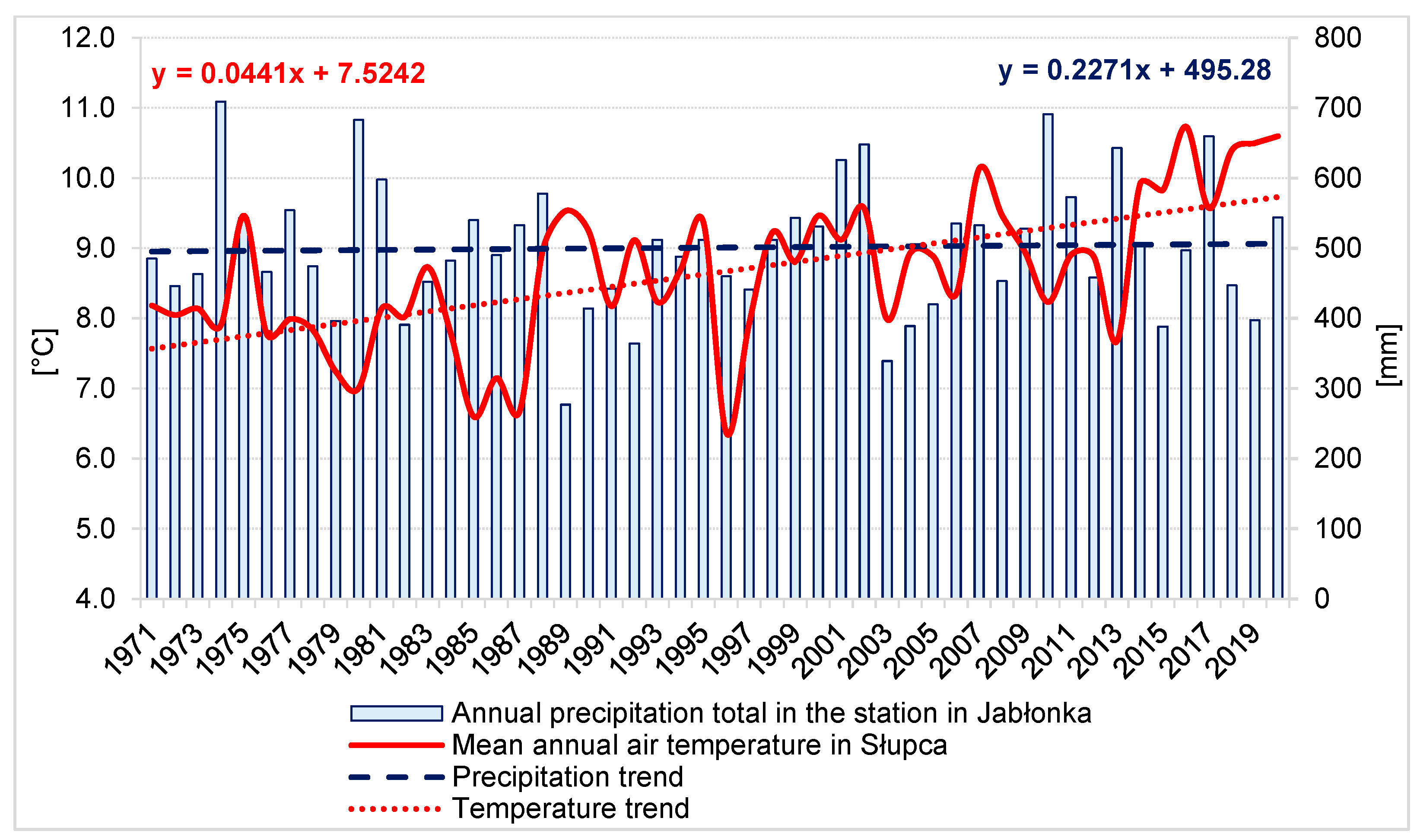
| Precipitation Station | Jabłonka | Wandowo | Konin | Słupca | Powidz |
|---|---|---|---|---|---|
| Normal precipitation | 501 mm | 474 mm | 545 mm | 496 mm | 532 mm |
| Minimum precipitation | 277 mm | 280 mm | 329 mm | 275 mm | 302 mm |
| Maximum precipitation | 709 mm | 666 mm | 901 mm | 665 mm | 745 mm |
| Trend | (+) | (+) | (+) | (+) | (+) |
| Parameter | Units | Mean | Min. | Max. |
|---|---|---|---|---|
| pH | - | 8.3 | 8.2 | 8.4 |
| temperature | °C | 12.3 | 2.3 | 24.5 |
| oxygen | mg O2 L− | 11.4 | 8.7 | 13.5 |
| total suspension | mg L− | 9.8 | 3.1 | 17.0 |
| chlorides | mg Cl L− | 9.6 | 7.5 | 17.0 |
| sulphur | mg S L− | 115 | 96 | 140 |
| iron | Mg Fe L− | 0.150 | 0.021 | 0.358 |
| BOD5 | mg O2 L− | 1.72 | 1.76 | 1.77 |
| COD-Cr | mg O2 L− | 10.3 | 8.4 | 13.6 |
| total nitrogen | mg N L− | 1.84 | 0.54 | 3.60 |
| total phosphorus | mg P L− | 0.223 | 0.099 | 0.358 |
| ammonium | mg N-NH4+ L− | 0.16 | 0.06 | 0.22 |
| permanganate index | mg O2 L− | 3.42 | 2.81 | 3.91 |
| electrical conductivity | µS cm− | 656 | 579 | 756 |
| solute concentration | mg L− | 421 | 374 | 456 |
| nitrates | mg N-NO3 L− | 0.20 | 0.08 | 0.30 |
| nitrite | mg N-NO2 L− | 0.008 | 0.000 | 0.015 |
| phosphates | mg P-PO43− L− | 0.225 | 0.02 | 0.84 |
| Kjeldahl nitrogen | mg N L− | 1.16 | 0.50 | 2.04 |
| manganese | mg Mg L− | 0.25 | 0.02 | 0.70 |
| alkalinity | mg L− | 224.75 | 207 | 242.5 |
Disclaimer/Publisher’s Note: The statements, opinions and data contained in all publications are solely those of the individual author(s) and contributor(s) and not of MDPI and/or the editor(s). MDPI and/or the editor(s) disclaim responsibility for any injury to people or property resulting from any ideas, methods, instructions or products referred to in the content. |
© 2023 by the authors. Licensee MDPI, Basel, Switzerland. This article is an open access article distributed under the terms and conditions of the Creative Commons Attribution (CC BY) license (https://creativecommons.org/licenses/by/4.0/).
Share and Cite
Nowak, B.; Szadek, P.; Szymański, K.; Lawniczak-Malińska, A. Concept and Implementation of Solutions Improving Water Relations in the Area of the Flooded Opencast Lignite Mine Kazimierz Północ in the East Wielkopolska Region (Central-West Poland). Water 2023, 15, 706. https://doi.org/10.3390/w15040706
Nowak B, Szadek P, Szymański K, Lawniczak-Malińska A. Concept and Implementation of Solutions Improving Water Relations in the Area of the Flooded Opencast Lignite Mine Kazimierz Północ in the East Wielkopolska Region (Central-West Poland). Water. 2023; 15(4):706. https://doi.org/10.3390/w15040706
Chicago/Turabian StyleNowak, Bogumił, Paweł Szadek, Krzysztof Szymański, and Agnieszka Lawniczak-Malińska. 2023. "Concept and Implementation of Solutions Improving Water Relations in the Area of the Flooded Opencast Lignite Mine Kazimierz Północ in the East Wielkopolska Region (Central-West Poland)" Water 15, no. 4: 706. https://doi.org/10.3390/w15040706