Article

A Quantitative Approach to the Watershed Governance Prism: The Duero River Basin, Mexico

by
Felipe Armas Vargas
1,
Oscar Escolero
2,
Samuel Sandoval Solis
3,
Luzma Fabiola Nava
4,5,*,
Marisa Mazari Hiriart
6,
Claudia Rojas Serna
1 and
Oliver López-Corona
7
1
Departamento de Ingeniería de Procesos e Hidráulica, CBI, Universidad Autónoma Metropolitana-Iztapalapa, Ciudad de México 09340, Mexico
2
Departamento de Dinámica Terrestre y Superficial, Instituto de Geología, Universidad Nacional Autónoma de México, Ciudad de México 09340, Mexico
3
Department of Land, Air and Water Resources, University of California Davis, Davis, CA 95616, USA
4
CONACyT—Departamento de Ingeniería Geomática e Hidráulica, División de Ingenierías, Campus Guanajuato, Universidad de Guanajuato, Guanajuato 38096, Mexico
5
International Institute for Applied Systems Analysis (IIASA), 2361 Laxenburg, Austria
6
Laboratorio Nacional de Ciencias de la Sostenibilidad, Instituto de Ecología, Universidad Nacional Autónoma de México, Ciudad de México 09340, Mexico
7
CONACyT—Instituto de Investigaciones en Matemáticas Aplicadas y en Sistemas (IIMAS), Universidad Nacional Autónoma de México, Ciudad de México 04510, Mexico
*
Author to whom correspondence should be addressed.
Water 2023, 15(4), 743; https://doi.org/10.3390/w15040743
Submission received: 1 November 2022 / Revised: 25 January 2023 / Accepted: 2 February 2023 / Published: 13 February 2023

Abstract

:
Advances have been made in water resource investigation due to the implementation of mathematical models, the development of theoretical frameworks, and the evaluation of sustainability indices. Together, they improve and make integrated water resource management more efficient. In this paper, in the study area of the Duero River Basin, located in Michoacan, Mexico, we schematize a series of numerical indices of the Watershed Governance Prism to determine the quantitative status of water governance in a watershed. The results, presented as axes, perspectives, and prisms in the Axis Index, Water Governance Index, and Watershed Governance Prism Index, provide the conclusion that it is possible to establish and evaluate the Watershed Governance Prism Index using our numerical implementation of the Watershed Governance Prism theoretical framework. Thus, it is possible to define a quantitative status and evoke how water governance is being designed and implemented in a watershed.

1. Introduction

Water crises will persist until governance at the watershed level is renewed, innovated, and adapted. Governance is the interaction between the State and society regarding the management of resources and provision of services; it is an integrative process within an institutional framework used to solve collective problems through the participation of society and the State. Water governance is a multisectoral arrangement of systems (political, social, economic, and administrative) used to develop and manage water resources [1]. Watershed governance goes further and addresses water and land issues at the regional scale, the provision of water services, and the protection and conservation of aquatic ecosystems [2]. Successful watershed governance frameworks include the State sharing the leading role, and public policies are established by a consensus of all the actors involved in water management [3]. As water crises are governance crises [4], effective governance is necessary to address most water-related problems [5].
Integrated water resource management approaches are more likely to promote a transition toward sustainable development, focusing on problem-solving using a system’s approach [6]. Different water–environmental management approaches have been proposed that include integrated water resources management worldwide [7]. EcoHealth is an Ecosystem approach to health (used in America, Africa, and Asia) [8]; there are also the Ecosystem Approach (Central and South America) [9], the Water Framework Directive (Europe) [10], the Watershed Governance Prism (Canada) [11], and the Sustainability Wheel (Switzerland) [12]. Local, state, national, and international governmental agencies and research groups have proposed all of these approaches. Thus, there is a need for resource management frameworks to be more inclusive and embrace mixed-method approaches [13]. Parkes et al. (2010) argue that the WGP can be used for water and environmental resources management in watersheds, given that the WGP is a contemporary theoretical framework that uses an inclusive and holistic approach.
The WGP uses a systems approach, and it integrates four main components (Figure 1): watersheds, ecosystems, health/well-being, and social systems. These four components can be graphically seen as a tetrahedral prism. From the mutual interaction between these four components (graphically displayed as vertices), six linear axes are formed: (1) ecosystems and health/well-being; (2) watersheds and ecosystems; (3) watersheds and health/well-being; (4) watersheds and social systems; (5) social systems and health/well-being; (6) ecosystems and social systems. In turn, the interaction between the prisms’ axes forms four surfaces representing four different perspectives of water governance. Perspective A consists of water governance for sustainable development (links: watersheds, ecosystems, and social systems). Perspective B consists of water governance for ecosystems and well-being (links: watersheds, ecosystems, and health/well-being). Perspective C consists of water governance for the social determinants of health (links: watersheds, social systems, and health/well-being). Perspective D consists of water governance to promote socio-ecological health (links: ecosystems, social systems, and health/well-being). The integration between the four perspectives (A, B, C, and D) makes up the WGP [11], which facilitates integrated watershed governance and allows us to better understand the interactions between the four perspectives of water governance [11,14].
The overarching goal of this study is to evaluate the water resources management of a basin using the WGP framework. Three scenarios are considered: the natural scenario, where there is no influence of human development in the basin; the regulated scenario, which considers historic water resources management; and the future scenario, which considers climate change. Our main hypothesis is that it is possible to evaluate and compare water resources management strategies at the watershed scale using the WGP. First, each of the WGP axes was quantified using indices, which are useful tools that help synthesize information about the relationships between the environment, economy, and society, as they allow the complex phenomena to be conceptualized and condensed from a dynamic environment to a quantitative value [15]. The indices used for each axis were tractable, adequate for evaluating each relationship, simple, and used only the necessary indices [16]. Second, a perspective index was quantified to summarize the results from the axes; this approach allowed us to compare the performance among WGP perspectives. Finally, a proposed Watershed Governance Prism Index was estimated as the summary of the framework. The proposed WGPI is a versatile summary index that can be used to evaluate water resources for development by including feedback from the interested parties and feedback on the resources intended to be evaluated in the watershed.
Other research studies have evaluated water and environmental resources management by integrating theoretical approaches to management [11,12,17,18,19], using mathematical models [20,21,22], and developing water resources assessment indices [12,18,19,20,23]. The novelty of our research study is the proposal of a quantitative framework for evaluating the WGP in a watershed using indices to summarize the performance by axes, perspectives, and the entire prism. In this work, the quantitative status of water governance is referred to as the consequence and impact of poor decisions made in water resource governance. The case study selected was the Duero River Basin (DRB), located in Michoacan, Mexico, due to its great natural resource variety and various problems, as well as being a representative area of the central region of Mexico.

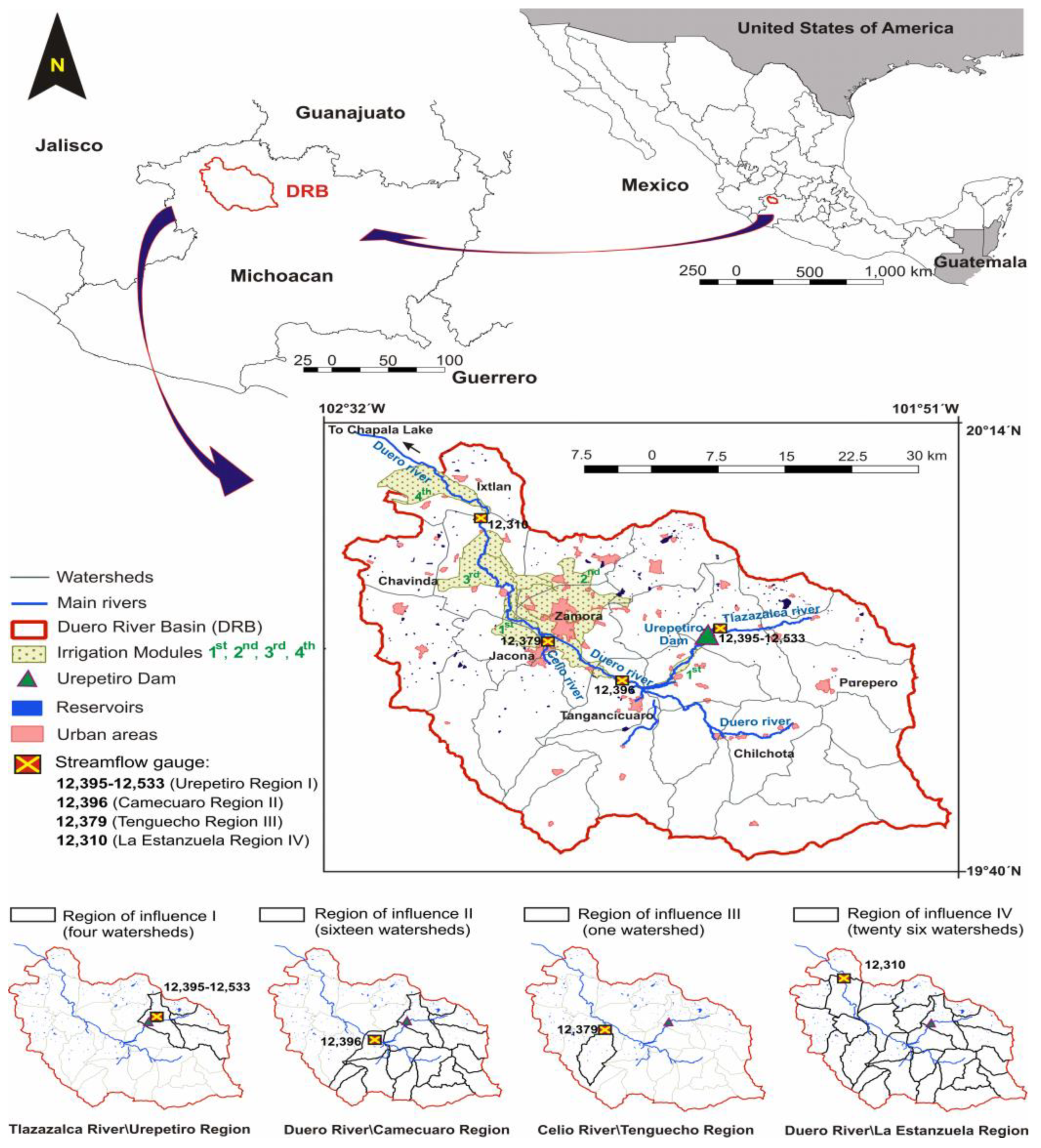
1.1. The Duero River Basin (DRB)

The DRB has an area of 2198 km2 and is located in the northwest part of the State of Michoacan in Mexico (Figure 2). The headwaters of the Duero River is the springs located in the town of Carapan, and its main tributaries are the Celio and the Tlazazalca rivers. The DRB possesses a wealth of natural and water resources, such as rivers, lakes, springs, aquifers, pine and oak forests, and geysers. Numerous fish and macroinvertebrate species represent the aquatic biological diversity. Additionally, there are places where people can enjoy recreational and ecosystem services, such as Lake Camecuaro National Park, La Beata hill, the Geiser de Ixtlan Recreation Center, and various spas, providing visitors with the opportunity to interact closely with the environment. There are also reservoirs, a hydroelectric power plant (El Platanal), agricultural areas, canals, extraction wells, treatment plants, and drinking water systems, which together comprise the hydraulic infrastructure [24,25,26]. Watersheds are the most appropriate planning unit for water resources management because they consider the natural hydrologic boundary and they explicitly consider river ecosystems [27,28]. The DRB is divided into four regions representing the main areas of the DRB, which are bounded by their respective streamflow gages. The DRB is a suitable area of analysis for water resources management. It integrates four watersheds in the Region of Influence I or Urepetiro Region, sixteen in Region II Camecuaro, one in Region III Tenguecho, and twenty-six in Region IV La Estanzuela.

1.2. DRB Problematic

Despite its natural wealth, the DRB faces adversities that affect the river flow regime, its riparian corridor, and aquatic ecosystems, such as deforestation, erosion, change of land use for agricultural activities, introductions of exotic species, raw wastewater discharge into rivers, and a lack of wastewater treatment. In terms of agriculture, a lack of efficient irrigation and eutrophication in irrigation channels caused a loss of biodiversity and water quality degradation due to the discharge of agricultural waters that pollute the river, reduce water availability, and degrade the habitat for freshwater ecosystems. Other activities that threaten the health of freshwater ecosystems are the increasing urbanization of stretches of rivers, the lack of impermeable sites for solid waste disposal, and the pressure exerted by users of irrigation modules located downstream of the Duero River due to not being able to use better-quality water, since the river receives discharges upstream [24,25].

1.3. Factors Impacting Water Resources in the DRB

The Duero River receives raw wastewater discharges from three main cities: Tangancicuaro, Zamora, and Jacona. These communities and communities downstream have not registered widespread enteric diseases, suggesting that the water dilutes pollutants. In addition, Zamora and Jacona also discharge water pollution from industrial, agricultural, and service economic activities. Unfortunately, raw wastewater discharge into rivers exists due to a lack of enforcement of current regulations and a lack of funding and functional infrastructure for its treatment. The sanitation system in the region comprises sewage and drainage services, which generally discharge into agricultural-irrigation infrastructure. Some populations have treatment plants, although they have low efficiency levels, except for the municipality of Zamora (which operates at 90% efficiency) [24].
Regarding the water supply and scarcity in the towns of La Luz, El Valenciano, and El Limón, there is usually one well per community that supplies water for 3 to 8 h a day, although the water presents boron problems. All these communities live under stress due to the short duration of the water supply and the high electricity cost. Some communities even have legal disputes over the distribution of water volumes [24,26].
Moncayo-Estrada et al. (2015) evaluated the biotic integrity index in the Duero River to compare it with previous years (1986, 1991) and contrast the health or contamination state of the river ecosystem. They found that the Etucuaro region has retained a fair condition, while Lake Camecuaro changed from a good to fair status; additionally, the El Platanal watershed status was poor, and that of Zamora, La Estanzuela, and San Cristóbal “A” changed from fair to poor. Bacterial contamination was found from the beginning of the Cañada de Los Once Pueblos narrow valley (in the Municipality of Chilchota) to the Zamora valley limits, except for the Carapan and Camecuaro springs [24].
As the waters of the Duero River move downstream, water quality decreases. For example, contamination due to Escherichia coli limits the diversion of water for high-value fruits and vegetables (such as strawberries) in Irrigation Modules 2 and 3 because water contaminated with raw sewage discharges upstream. Furthermore, Module 4 spends more money treating the water because it is located at the basin outlet, where all raw sewage discharge occurs [24]. This is coupled with the great efforts of the Zamora treatment plant. The function of the Irrigation or Surface Modules is to operate, preserve, and manage the hydraulic infrastructure and volumes under concession.

2. Materials and Methods

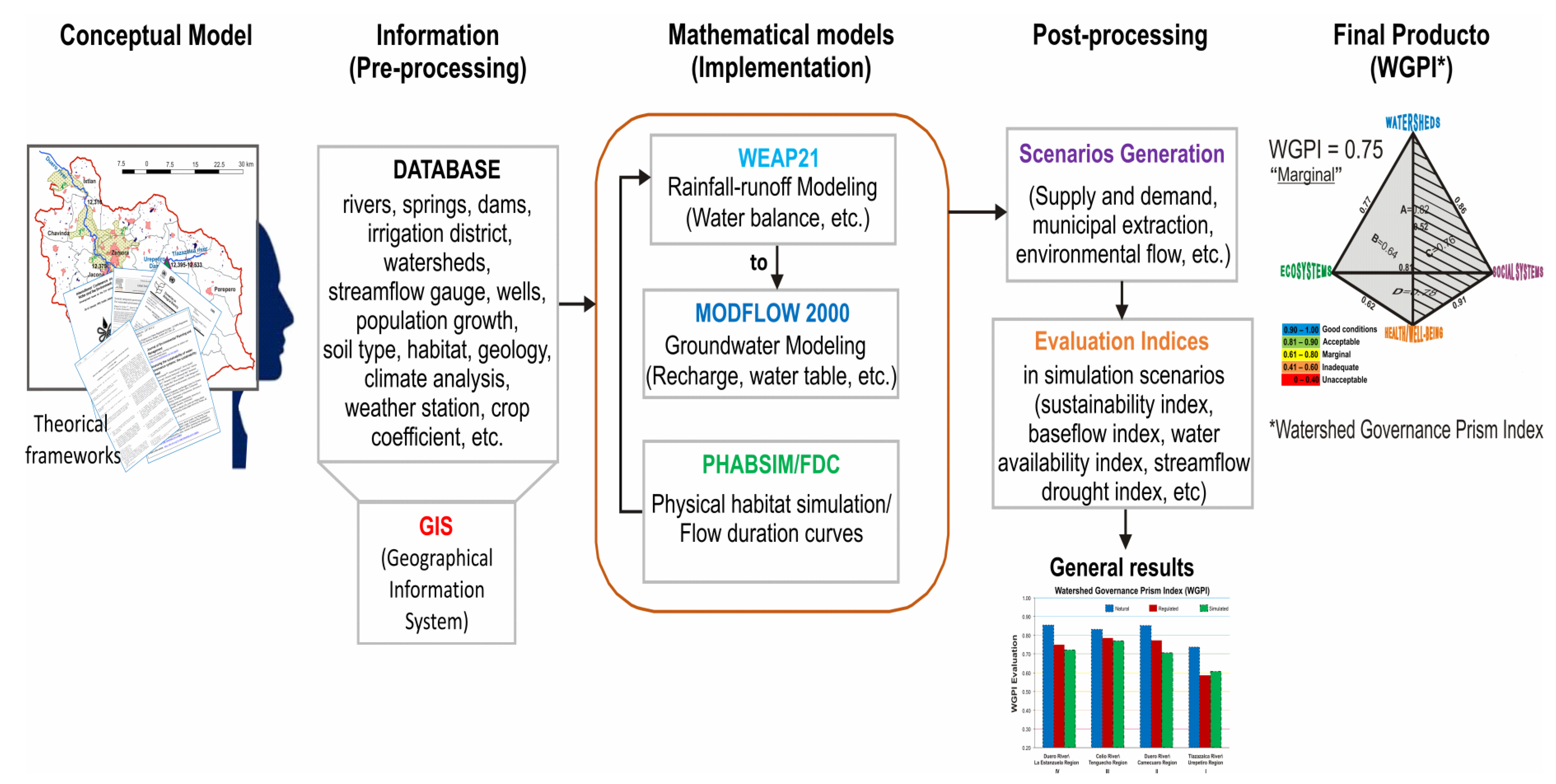
2.1. Conceptual Model

The model is a simplified conceptualization of reality and quantitative mathematical representation of the site [29] capable of representing the different processes involved in the groundwater, surface water, freshwater ecosystem’s response, and water resources operation of the DRB (Figure 3). For the groundwater system, a groundwater simulation model was built using the MODFLOW platform [30]; it considered the area of the aquifer, geological and hydrogeological media, soil type, available water resources (rivers, springs, and wells), recharge areas, water conditions at the aquifer boundary, water table, and demand sites. For surface water hydrology, a rain-runoff model was built using the WEAP platform [31]. It considered the rainfall-runoff processes of 27 watersheds, climate and land-use data, and historic discharge at four streamflow gauges that were used for calibration and validation purposes: Urepetiro (gauge 12,395–12,533), Camecuaro (gauge 12,396), Tenguecho (gauge 12,379), and La Estanzuela (gauge 12,310). In terms of the ecosystem’s response to streamflow, a habitat-suitability model was built in the PHABSIM platform to simulate the suitable habitat according to the streamflow at Ixtlan de Los Hervores, which is located at the outlet of the DRB. Then, a water resources planning model was built in the WEAP platform to represent the water-allocation system in the DRB. The collection of information was carried out in governmental and academic institutions, as well as from related projects available in electronic media [24,25]. Finally, the WGP [11] was used as a theoretical framework for evaluating water-management scenarios. After the scenarios were generated, they were evaluated using the WGP axes, perspectives, and prism indices.

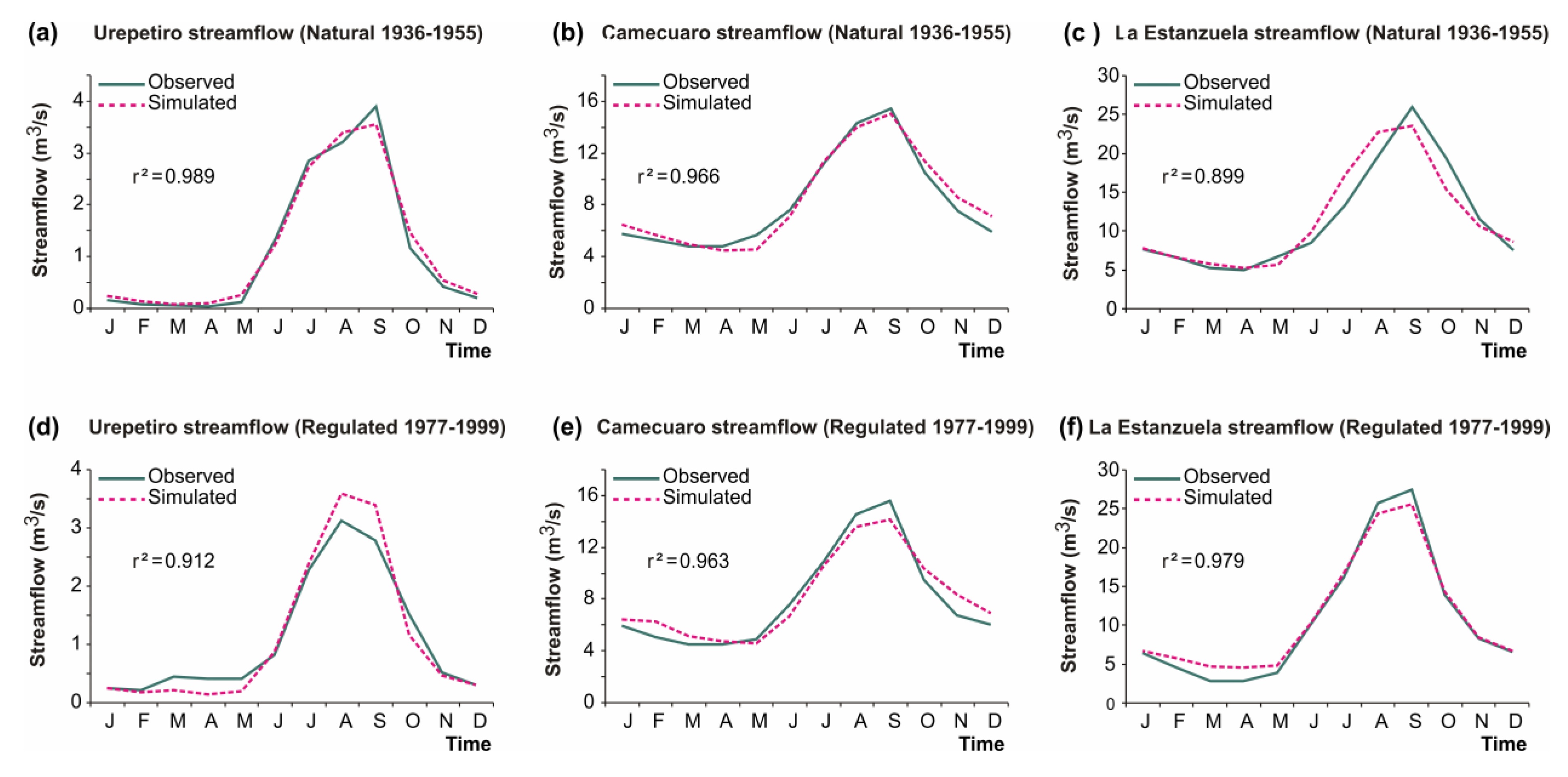
2.2. Surface Water and Groundwater Hydrologic Modeling

Hydrologic and water planning models can be used to evaluate water-management strategies [32]. This research study used two hydrologic models to represent surface water and groundwater hydrology. For groundwater hydrology, the MODFLOW [30] platform was used to model the hydrodynamic simulation of underground flow in porous media. The parameters with greater sensitivity were the horizontal hydraulic conductivity and specific performance. The hydraulic conductivity and storage coefficient parameters were adjusted. They were calibrated for the years 1999 and 2007 using piezometric information. The root mean square error (RMS) from 1999 and 2007 was 7.54 m and 10.01 m, normalized (nRMS) as 3.7 and 4.4%, respectively.
For surface water hydrology, the Soil Moisture algorithm built in the WEAP [31] platform was used to calculate the water balance for each watershed. The La Estanzuela gauge station, located close to the outlet of the DRB, was used for calibration purposes. The most sensitive parameters were the preferential flow coefficient and soil water capacity. The calibration consisted of minimizing the RMS (2.3 m3/s and nRMS of 5.6%), simulating the annual average volume in the mainstem and tributary rivers [33], and maximizing the Nash–Sutcliffe criterion (NS = 0.94) (Table 1). Once the models were calibrated individually, both models were linked, followed by homologizing the time step to monthly in each model. After they were linked, both models were run simultaneously using the WEAP platform. The NS coefficient evaluates the goodness of fit for the validation of the model [34].
Figure 4 shows the calibration of the observed and simulated monthly runoffs for the referred natural period from 1936 to 1955 (a, b, c) and the regulated period from 1977 to 1999 (d, e, f). The six calibration hydrographs refer to the streamflow gauge belonging to the Urepetiro, Camecuaro, and La Estanzuela regions (Figure 1, lower section).

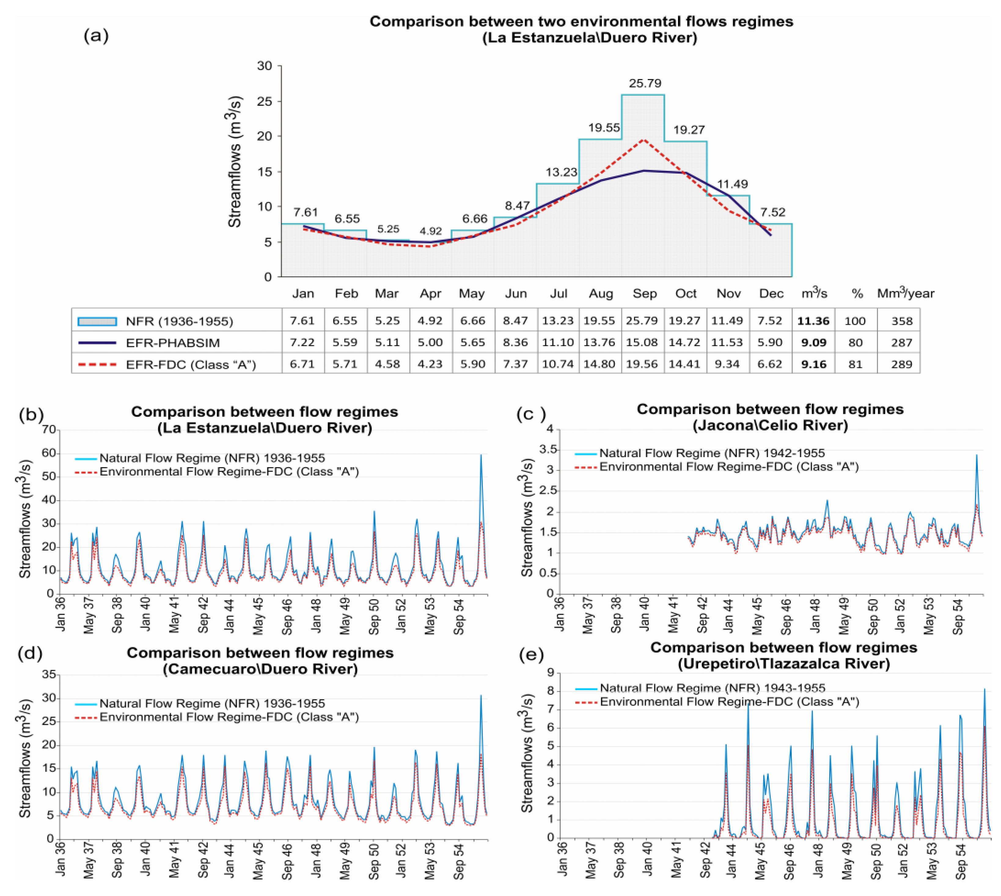
2.3. Methods for Determining Environmental Flows

Various methodologies have been developed to establish environmental flows [35]. The In-Stream Flow Incremental Methodology (IFIM) is a theoretical framework used to assess the requirement of environmental flow in rivers. For the IFIM, the Physical Habitat Simulation Model (PHABSIM) calculates the amount of habitat available for different target species within a river section [36]. In this study, the IFIM was limited only to a stretch of the Duero River [37] (Figure 5a). In addition, the flow duration curves (FDC) approach was used when there were streamflow data for three-gauge stations. The FDC method recommends instream flows in regulated streamflow; it defines Environmental Management Classes (EMC) to maintain a given flow rate for ecological conservation. Both methods were compared on a monthly time scale. The environmental flow regime (EFR) curves at 80% and 81% of the natural flow (from 1936 to 1955) were adopted as the environmental flows. The EMC for the proposed EFR curves falls in the category of Class A natural flow, which represents minor modifications within the river channel and habitat [38]. Figure 5b–e show the annual behavior of the environmental flows proposed from natural flows for a 20-year analysis period for the Estanzuela (12,310) and Camecuaro (12,396) gauging stations, 14 years for the Tenguecho gauging station (12,379), and 13 years for the Urepetiro gauging station (12,395–12,533).

2.4. Water-Planning Model

A water-planning model for the DRB was built to assign water to users according to a water-allocation system established in the National Water Law (LAN—Ley de Aguas Nacionales) [39]. A total of 47 surface water and 27 groundwater demands were considered in the model. Three scenarios were evaluated: (1) the Natural scenario, where there is little influence of human development in the basin from 1936 to 1955; (2) the Regulated scenario, which considers historic water resources management from 1956 to 1999—this is a close representation of the current baseline conditions; and (3) the Simulated scenario, which considers the effects of climate change and environmental flows using the EFR from 2000 to 2070. Two carbon emission scenarios were considered in the simulated scenario: high (A2) and medium (B2) carbon emission scenarios. The outputs of two global circulation models were used: HADGEM1 for the B2 scenario and MPIECHAM5 for the A2 carbon emission scenario model [40] (Figure 6).

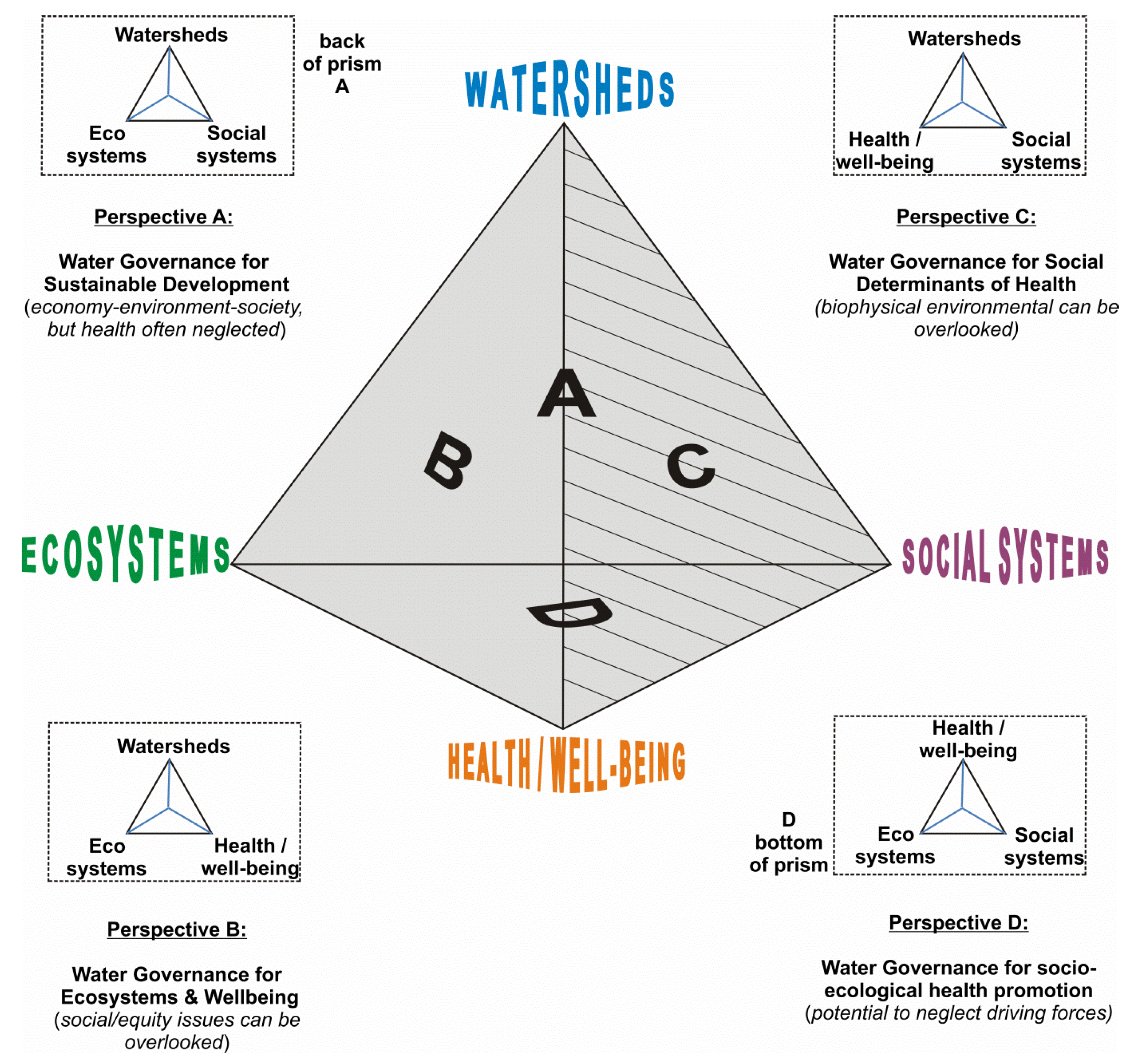
2.5. Relationship between the Indices and WGP Axes

The WGP is not intended to cover everything; however, it enables an understanding of four aspects of water management. From the four vertices of the prism (ecosystems E, health/well-being H, watersheds W, and social systems S), other linear links can be generated, such as ecosystems–health/well-being (EH), watersheds–ecosystems (WE), watersheds–health/well-being (WH), watersheds–social systems (WS), social systems–health/well-being (SH), and ecosystems–social systems (ES). In turn, the direct link between these axes forms four planes or perspectives, established as watersheds–ecosystems–social systems (WES), watersheds–ecosystems–health/well-being (WEH), watersheds–social systems–health/well-being (WSH), and ecosystems–social systems–health/well-being (ESH). The integration of the four perspectives related to water governance gives rise to the WGP [11].
A set of water resources indices were compiled and evaluated considering two characteristics: (1) ease of evaluation considering the available data from the hydrologic, environmental, and planning models; (2) uniqueness of the indicators compared to the rest of the indices (i.e., nonredundant). The selection of the indices was based on information from historical and simulated records. For example, there was a series of historical records of gauge stations in rivers. The natural flows and EMCs were derived from the observed streamflow of at least 20 years. Another example is the estimation of the habitat availability time series using PHABSIM, streamflow, and the weighted usable area curves.
Thirteen indices were selected for evaluating the six axes of the WGP—eleven from the literature and two proposed by the authors. Each index was characterized as follows: name, mathematical expression, component variables, and a relevant WGP component that can be associated. Table 2 shows the indices that were used in the WGPI evaluation. For instance, the Sustainability Index (SI; [41]) is associated with policies that seek to reduce the negative impacts of undesirable events while meeting current and future water needs for humans and the environment from any water source (surface water and groundwater). It also measures the adaptive capacity of a system to reduce its vulnerability to stressors. Another example is the Water Availability Index (WAI; [42]); this is an index (of risk) that considers water availability and human water demands, and it compares the available water to the demands of all sectors (such as domestic or agricultural sectors). The Environmental Flow Regime (EFR; [38]) uses flow duration curves (FDCs) to calculate six Environmental Management Classes (EMCs) by gradually reducing the natural flow regime by a fixed number of percentiles. Finally, two volumetric factors were proposed for the flows or return flows discharged by the demand sites (cities, irrigation modules, channels, and treatment plants) to determine the volumetric dilution degree between the incorporation of the return flow to the rivers and the hydraulic network. This established the factors of flow with treatment and without treatment (TreaF and UntreaF). The first is the relationship between the treatment return flow (QTreaF) emitted by the treatment plant in the WEAP model and the downstream river flow (QDRF) leaving the treatment plant. Similarly, the second is the relationship between the return flow (from cities) without treatment (QUntreaF) and the downstream river flow (QDRF).
A comprehensive evaluation of water resources indices was performed to identify indices that could relate two WGP components and provide a quantitative framework for each of the WGP axes. Table 3 shows the relationship between the indices and WGP axes; it demonstrates that some indices can be associated with more than one WGP axis. For example, the SI was associated with the WE, WS, EH, SH, and ES axes; its versatility enabled the evaluation of flow from various sources (springs, rivers, and bypass channels), water uses (municipal and environmental), and aquifer storage. The EFR index was associated with the WE and EH axes; the EFR evaluates the protection of environmental flows and loss of ecosystem services. The benefit–cost ratio (BCR; [20]) was associated with the ES axis, considering the main crops of the Irrigation Modules and their associated water right volumes. The WAI was associated with the SH axis; it relates social policies and resource behavior (water availability) that can influence the health and community development of society, increasing inequality and poverty. The Baseflow Index (BFI; [44]) was associated with the WE axis, as it is linked to the protection of baseflow. The Standardized Precipitation Index (SPI; [45]), Streamflow Drought Index (SDI; [46]), and Flash Flood Magnitude Index (FFMI; [48]) are associated with the WH axis; they evaluate natural disasters that generate floods, droughts, and their effects on irrigation and drainage systems—the same was found for the remaining five indices (CVB; [43], RP; [47], UAH; [36,49], TreaF and UntreaF), and the application objective of each index was associated with the respective thematic axis of the prism axes (CVB–WS; RP–WH; UAH–EH; TreaF–WH; and UntreaF–EH) (Table 3). This holistic approach for selecting indices has the advantage that the selection of indices is open to the professional judgment of each individual who decides to use the WGPI. That is, other indices can be chosen by how they fit each WGP axis. In addition, for index selection, decision making can be achieved through multicriteria methods and thus choose from a range of indices with better ranking. Additionally, each selected index is a function of the thematic axes of the WGP. It should be noted that the index evaluation, prior to implementing the WGPI, will depend on which environmental or social basin water resources are to be evaluated. For instance, if the river base flow is to be evaluated, an index that references the base flow has to be chosen.

2.6. Proposal of the Watershed Governance Prism Index (WGPI)
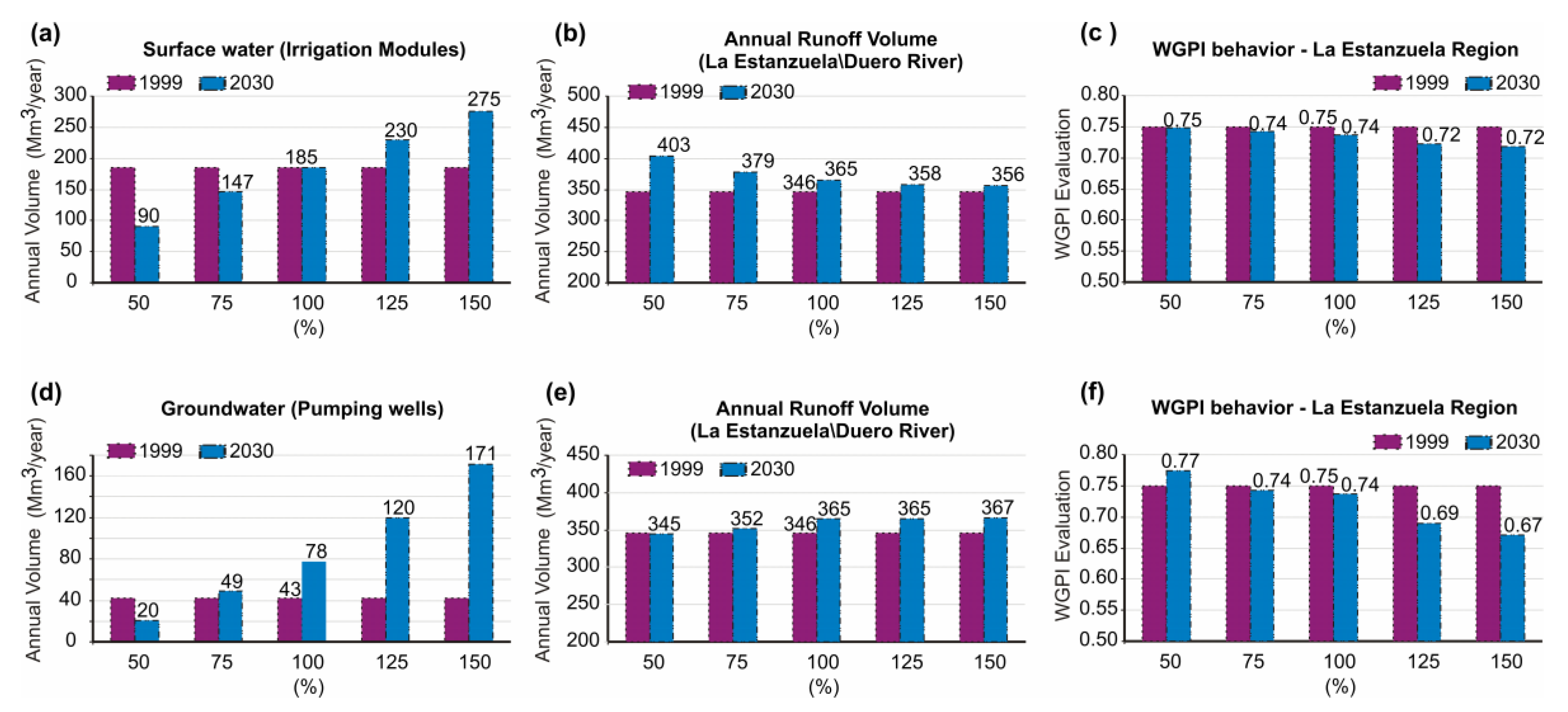
First, most of the indices used in Table 3 have already been normalized from their origin to a generic scale from 0 to 1, except for some, such as the proposed Treated Factor (TreaF), Untreated Factor (UntreaF), CVB, and BFI. The score-normalization method (Min–Max Method) proposed by [50] consists of a transformation of the original value of all the indicators to a common scale with a range from 0 to 1 (Equation (1)), considering 1 as a more favorable condition and 0 as unfavorable.
X n o r m a l i z e d   s c o r e = X X m i n i m u m X m a x i m u m X m i n i m u m
Here, X is the original value of each indicator; Xnormalized score is the normalized value; and Xmin and Xmax are the minimum and maximum values of the indicator set, respectively.
Second, for each axis, the prism axes index (xaxis) is calculated using the geometric mean of the associated indices (xindices i) (Equation 1). For example, the watershed–ecosystems axis (xWE) was formed by the SI, BFI, and EFR indices. This approach was applied to every axis. It should be noted that the geometric mean has an advantage over the arithmetic mean because it is less affected by extreme values in a skewed distribution [51]. That is, when we evaluated the respective indices of each prism axis, there were some percentage variations. Thus, we decided to first evaluate with a geometric mean and thus obtained a more stable value. Subsequently, with the following indices, such as the perspective (PI) and the WGPI, it was more appropriate to use an arithmetic mean.
x a x i s = x 1 x 2 x n n
Here, xaxis is the Axes Index (AI) for the associated axes of the prism, and xn refers to the associated indices used on a given axis.
Third, the Perspective index (yperspective) was calculated for each of the four perspectives; this index is the arithmetic average of the three axes that form a given perspective (see Equation (2)). For example, for Perspective A, Water Governance for Sustainable Development, the Perspective Index (yperspective A) is the arithmetic average of the axes of watershed–ecosystems (xWE), watershed–social systems (xWS), and ecosystems–social systems (xES). The same process was used for the remaining perspectives (B, C, and D).
y p e r s p e c t i v e   i = 1 3   i = 1 3   x a x i s   i   = x a x i s   1   + x a x i s   2   + x a x i s   3 3
Here, yperspective i is the Perspective Index (PI) or Water Governance Index (WGI), and the xaxis i is the axes index corresponding to a given perspective.
Fourth, the Watershed Governance Prism Index (WGPI) was calculated as the arithmetic average of the four Perspective Indices (yperspective i). Thus, the WGPI takes on a greater sense of governance, integrating the four perspectives of water governance (A, B, C, and D; Figure 1):
W G P I = 1 4   i = 1 4   y p e r s p e c t i v e   i  
where WGPI is the Watershed Governance Prism Index, and   y p e r s p e c t i v e   i   is the Perspective Index (PI) of the four perspectives (i). To avoid confusing the WGI with the WGPI, from now on, we will refer to the WGI as the Perspective Index (PI).

3. Results

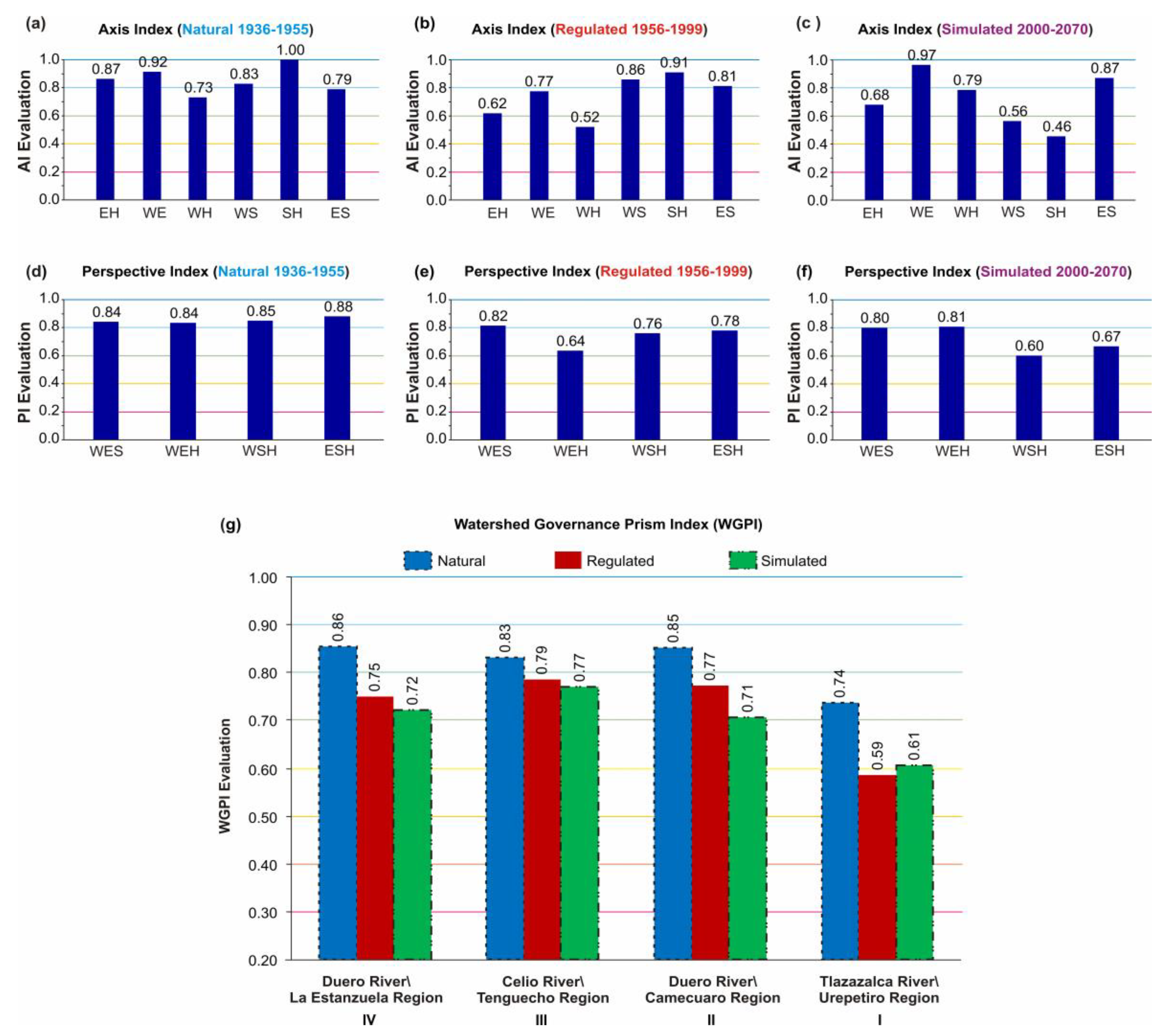
3.1. Indices for Prism Axes and Perspectives

Figure 7 shows the AI (Figure 7a–c) and PI (Figure 7d–f) results for the natural, regulated, and simulated periods. For the natural period (1936–1955), results for the AI (Figure 7a) and PI (Figure 7d) have higher indices values compared to those of the regulated and simulated periods. These results are expected because there was minimal human intervention in the region. For the regulated period (1956–1999), four of the six AI decreased (Figure 7b) and all the PI decreased (Figure 7e). These results reflect the increase in the construction of hydraulic infrastructure, agricultural activity, canals, and pumping. The AI and PI quantified the response between six linear axes and four perspectives that form the Water Governance Prism for three different periods. In addition, these indices were calculated for four regions, including Region IV (La Estanzuela), which represents the behavior of the whole DRB.
For the simulation period (2000–2070), the SH axis (Figure 7c) shows the largest reduction in performance compared to the natural and regulated periods. The SH axis is integrated by two indices: the SI, which evaluates the water supply for the municipal systems in the region, and the WAI, which evaluates the surface and groundwater availability. The increase in water demand and reduction in water availability caused the precipitous decrease in the SH axis. The SH value was 0.46, which was deemed inadequate. All the PI values fell into the acceptable category in the natural period (Figure 7d), while three out of four fell into the marginal category for the regulated period. In particular, Perspective B of water governance for ecosystems and health/well-being (WEH) had the greatest decrease (Figure 7e); this is because the AI that integrates this perspective (EG, WE, and WH) had a significantly low performance in this period.

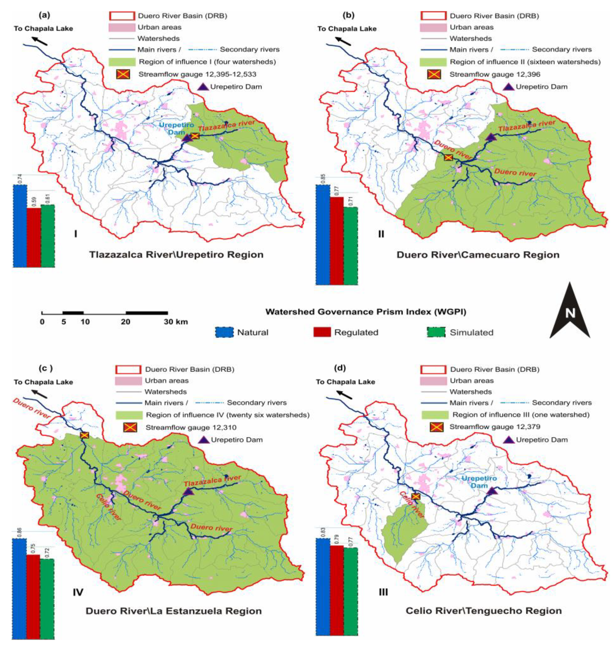
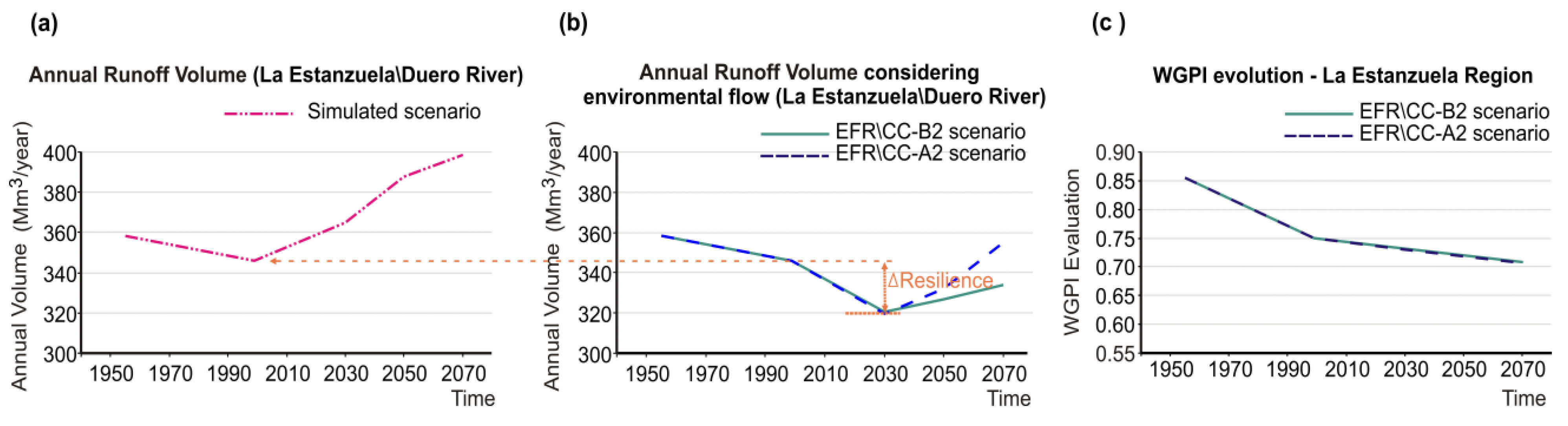
3.2. Watershed Governance Prism Index (WGPI)

Figure 7g shows the WGPI as a summary indicator for the natural, regulated, and simulated periods. Figure 8 shows the spatial extension of the four regions of the DRB. Results for Region I, Urepetiro (Figure 7g), have the lowest WGPI performance for all regions and periods: marginal in the natural period (WGPI = 0.74), inadequate in the regulated period (WGPI = 0.59), and marginal in the simulated period (WGPI = 0.61). The main river in Region I is the Tlazazalca River, an ephemeral river with a seasonal flow regime and a reservoir along its mainstem.
Results for Region II, Camecuaro (Figure 7g), have the best overall performance of all four regions: acceptable in the natural period (WGPI = 0.85) and marginal for both regulated (WGPI = 0.77) and simulated (WGPI = 0.71) periods. The main river of Region II is the Duero River, a perennial river with permanent flow and springs that feed the base flow of the river throughout the year. There is a downward WGPI trend in this region that shows a current trend of increased water consumption over time.
Results for Region III, Tenguecho (Figure 7g), have the most consistent WGPI performance for all periods: acceptable in the natural period (WGPI = 0.83) and inadequate for both the regulated (WGPI = 0.79) and simulated periods (WGPI = 0.77). The main river of Region III is the Celio River, a perennial river with permanent flow throughout the year that includes underground contributions from a shallow aquifer.
Finally, results for Region IV, La Estanzuela (Figure 7g), represent the performance for the whole DRB: acceptable in the natural period (WGPI = 0.86) and marginal for both regulated (WGPI = 0.75) and simulated (WGPI = 0.72) periods. There are three irrigation modules located in this region that have an extensive network of irrigation canals, as well as the most important cities in the region, Zamora and Jacona. Overall, the Duero River has suffered important human alteration that has modified its natural hydrology. Because of this continual human alteration through time, the WGPI of the simulated period decreased by 8% with respect to the regulated period, from 0.77 to 0.71, respectively. To mitigate human alteration, there is a need to implement environmental flow policies that mimic the natural flow regime [28].
Figure 9 shows a graphical display of the results for the AI, PI, and GWPI (Figure 7b,e,g) using the theoretical framework of the Watershed Governance Prism [11] for the regulated period in Region IV—La Estanzuela. Results for the four perspectives (PI) and six axes (AI) are shown. The WGPI is marginal (WGPI = 0.75); this result shows that significant improvements need to be made in multiple areas of the watershed to improve water management overall in the DRB. Similar graphical representations can be created for the natural and simulated periods for each region.
Figure 10 shows the annual runoff volume for the Duero River Region IV—La Estanzuela individually. Figure 10a demonstrates a downward trend in the annual runoff volume for the simulated period (1956–12999) and then a subsequent upward trend from 2000 to 2070 in the simulated period. Figure 10b shows the results for two added conditions to the simulated period: (1) considering the delivery of environmental flows throughout the basin and (b) evaluating medium (B2)- and high (A2)-greenhouse-gas-emission scenarios. The results of Figure 10b show a downward trend in the annual runoff of the Duero River until 2030 and an upward trend until 2070. The natural flow considered in this scenario is the amount of water that can be extracted from a river without compromising the integrity of ecosystems [53].
In addition, Figure 10b shows that the medium-emission scenario (B2) produces lower annual runoff than the high-emission scenario (A2). This is because the medium-emission scenario (B2) considers a decrease in precipitation (Table 4), while the high-emission scenario (A2) does not (Table 5). Figure 10b shows the response of the Duero River to climatic pressures and anthropogenic activities, such as climate change and water diversion for irrigation. Figure 10c shows the temporal values of the WGPI for the two climate emission scenarios (A2 and B2), considering the delivery of environmental flows for Region IV. Figure 10c shows a downward trend in the WGPI from the natural period in 1956 (WGPI = 0.85) and the regulated period in 2000 (WGPI = 0.75) until the end of the simulated period in 2070 (WGPI = 0.70). When considering a policy implementing environmental flows in the DRB, the results for the medium (B2)- and high (A2)-greenhouse-gas-emission scenarios are the same.
Table 4 shows the result of the temperature variation for various periods in time, using the ECC-B2. By 2030, the temperature increase will be 1.1 °C; by 2050, 1.6 °C; and 2.5 °C by 2070. These temperature increases are referred to the average historical period. The historical average annual precipitation of the region was calculated at 906 mm/year, increasing to 912 mm/year by 2030 and decreasing for the periods 2050 and 2070 by 898 and 882 mm/year, respectively.
Table 5 shows that the temperature increase is slightly higher in 2050 and 2080 (1.9 and 3.5 °C), with the exception of the year 2030, where it remains unchanged (at 1.1 °C). The average annual precipitation of the A2 scenario increased 0.3% (909 mm/year), being 0.7% lower than that calculated in the B2 scenario. However, the years 2050 and 2070 increased rainfall +1.3 and +4.3% (918 and 945 mm/year) regarding the historical period of 1950–2000 (906 mm/year). It can be seen that in both Tables there is no great difference between scenarios B2 and A2 for 2030. Similarly for the year 2050, there is little difference between the scenarios (B2 and A2) in temperature. However, precipitation decreases (–0.9%) in B2 and increases (+1.3%) in A2.
Figure 11 shows the comparison between the volume of surface water used for agricultural activity (Figure 11a) and groundwater pumping for the main water uses (Figure 11d). Figure 11a indicates the reference year (1999) and the simulation year (2030), with the surface water volume granted to the irrigation district (185 Mm3/year), in a variation interval (decrease and increase from 50 to 150%, respectively) to show the trend of the irrigation volume and its implication in the Duero River. The projection to 2030 (Figure 11a) at 100% shows the same assigned volume; however, the Duero River indicates a rise of 5.5%, probably contributed by the return flow (Figure 11b). As the percentage of diversion volume (150%) used by the irrigation modules increases, the volume of water in the Duero River (La Estanzuela gauging station) will reach a volume of 356 Mm3/year (Figure 11b). Between Figure 11a,b, a trend can be observed. As the diversion percentage decreases there will be an increase in the river volume, and vice versa. Figure 11c shows the WGPI evaluation with a stable trend between the decrease percentages with WGPI values between 0.75 and 0.74. This is not so for the increases in water diversion with a WGPI = 0.72, which still has an evaluation of the marginal observation.
Similarly, Figure 11d shows the pumped volume extracted up to 1999 (43 Mm3/year). In 2006, it reached 66 Mm3/year and by 2030, 78 Mm3/year. As the percentage of pumping decreases and increases (Figure 11d), the volume in the Duero River presents variations proportional to the extraction. For instance, when pumping decreases to 50% (20 Mm3/year), the volume in the Duero River presents a stable volume similar to the reference of 345 Mm3/year, but this is not so because when the percentage increases, so do the volumes in the river, probably contributed by the return flow volumes. The WGPI evaluation shows that the evaluation improves when the extraction percentage decreases to 50% with a WGPI = 0.77, and the evaluation decreases at higher extraction percentages, WGPI = 0.67. The WGPI evaluation is more sensitive for groundwater than for surface water.

4. Discussion

This study shows that it is possible to establish and evaluate the WGPI using the WGP theoretical framework [11]. Consequently, it is possible to define a quantitative state of water governance in a watershed. The anthropogenic activities developed in the DRB impact the watershed’s resources, as demonstrated by the WGPI through its evaluation scale. Possible measures that can be taken once the evaluation has been completed are as follows:
  • For “good condition” evaluations, few improvements will be necessary to implement in the watershed.
  • For “acceptable” evaluations, improvements will be recommended to maximize resources and verify that they are in good condition.
  • For “marginal” evaluations, significant improvements will be necessary for multiple watershed areas.
  • For “inadequate” evaluations, many improvements will be necessary for many areas throughout the watershed.
  • For “unacceptable” evaluations, the situation will be considered untenable.
These evaluations are examples and are at the discretion of the government actors involved in the care and protection of the watershed’s resources.
Figure 7 illustrates how the numerical evaluation of the components that comprise the WGP was accomplished, and it presents three modalities: (1) the AI, which is a partial evaluation of the status of the watershed’s water resources (flows, river habitats, rainfall behavior, and underground storage); (2) the PI, which is a comprehensive assessment of the status of different governance perspectives, such as sustainable development, ecosystems and well-being, the social determinants of health, and the promotion of socio-ecological health; and (3) the WGPI, which is an evaluation of the global state of governance in the watershed.
The numerical evaluations of the AI, PI, and WGPI respond directly to the water resources’ physical state (natural or regulated) in the watershed. Natural resources that present loss of quality, degradation, or alteration due to the constant stress (pressure) to which they are subjected generate negative effects with direct and indirect impacts on other ecosystems within the watershed. The issues result from poor management, insufficient human and financial resources, inoperative or failed water organizations, inadequate public policies, and inadequate government intervention and coordination. Taken together, all cause inadequate water governance in the system, making it possible to worsen problems instead of solving them [54]. Many existing issues involving water resource management are mostly due to a lack of management rather than an absence of resources [3].
These issues (Figure 12a) contribute to the degradation of ecosystem capabilities and water quality [24]. Therefore, it is necessary to reverse these adverse conditions [55]. The water crisis motivates governance actors to participate and organize to achieve sustainability and balance in the watershed. The Duero River Basin Commission (DRBC) was created in 2010 with this in mind while under the constant emergence of environmental threats in the watershed. This supports government actors working together to enhance the integrity of ecosystems [3]. Similarly, the WGP perspectives were used to propose actions aimed at environmental improvement in the watershed and reversal of the issues that impact it. Figure 12b illustrates some proposals or alternative solutions that promote sustainability and environmental health in the DRB using the information from work carried out in the last 15 years by Velázquez [24] and CONAGUA-IPN [25]. These improvement measures result from adequate water governance and are expected to positively affect the WGPI evaluation.
It is possible to determine how good or how badly water governance is exercised in the watershed using the evaluation of the prism indices. The symptoms of inadequate governance are represented by degraded rivers, intensive pumping, inefficient water use, excessive demand, inequality in access [56], and deficits in public service coverage and sanitation. Just as in the DRB, regions with a governance assessment of a marginal type of watershed were identified. Additionally, acceptable evaluations were identified, referring to good governance, by reaching agreements and actions with clear and transparent regulations to make decisions, recognizing rights and obligations, ensuring the participation of the parties, supporting accountability, performing audits [54], and creating effective policies to regulate and manage water resources [3]. When organizations can cope with each of these symptoms, they are considered to have adequate governance [56].
Problems that put pressure on the watershed can influence the WGPI evaluation negatively. A more positive evaluation could also arise with proposed actions taken to benefit the watershed. Figure 7b, the evaluation of the WH axis, presents a rating of 0.52 (inadequate); compared to the WGP axis (Figure 12a), it can refer to four characteristic issues of that axis. This is the same with the EH axis (0.62, marginal) and the axis of the EH prism (Figure 12a), which has the most issues associated with that axis. The allocation of issues depends on the number of themes identified, so it is open to incorporating more. However, the density of issues depends on the context of each axis. In Figs. 2b and 6a, similar behavior is identified, as the lowest PI was evaluated for WEH (0.64—marginal), which, compared to Perspective B of the WGP, has the highest density of issues (Figure 12a). In general, the WGPI can help us determine the adequacy or inadequacy of governance in a watershed.
Rivers must be allowed to flow with sufficient water to ensure downstream environmental benefits [57]. The scenario of demand for environmental water, class “A,” maintains the natural conditions in the ecosystem. This environmental-management category is based on the relationship between flow and ecological status through identifiable thresholds [38]. The flow rates can oscillate by taking the natural conditions of 1936–1955 as the upper threshold and the “A” class environmental requirement as the lower threshold. For example, Figure 10b functions as the natural threshold of Figure 10a, with a difference in volume in 2030 (simulated) of approximately 40 Mm3/year, equivalent to 1.26 m3/s. The WGPI’s assessment of climate change demonstrated a few notable changes when comparing the current trend and environmental-requirement scenarios. The exposure to climate change in the DRB presents a degree of medium climatic stress and low sensitivity, which is how the system is potentially modified by external forces [58]. The advantage of simulating the environmental scenario is that it provides a minimum threshold for maintaining flow volumes within a natural status. The WGPI has a higher assessment when the water-extraction percentage of the river is lower, and the assessment decreases as the percentage of extraction increases.
The highest average evaluation of the WGPI was for the Tenguecho Region (a single watershed), and the lowest was for the Urepetiro Region (four watersheds). The Camecuaro Region (half DRB), which extends from the middle to the top part of the DRB, was evaluated as slightly higher than the La Estanzuela Region. The latter region represents the entire DRB. These results concord with places with higher and lower water quality in the DRB. The purest water supplies stem from the Celio River (Tenguecho Region), while the Tlazazalca River (Urepetiro Region) is visibly contaminated and anoxic, with overabundant concentrations of nitrates and bacteria [25]. In 2009, the biotic integrity index in the Duero River was evaluated to compare it to 1986 and 1991, and results demonstrated that the Etucuaro locality had changed little (Urepetiro Region). Camecuaro Lake transitioned from good to regular (Camecuaro Region), and from the middle of the DRB until the exit of the watershed, the conditions changed from regular to poor. This environmental degradation is related to human activity and water use [55].
Figure 10b shows the resilience of a river system for the specific case of the EMC class “A” simulation, called “natural flow”, since a lower threshold is indicated for the volumetric regulation exerted upon the river. With the incorporation of the environmental flow regime, it was determined that the annual average regulatory activity from 1977 to 1999 and the simulation of the status-quo scenario remained within the intervals set by the simulation of EMC “A.” That is, the regulation period did not exceed the lower threshold set by the simulated environmental requirement for the Duero and Tlazazalca rivers. In the La Estanzuela Region, the governance index did not show significant variation between the simulation scenario and the climate scenarios; even with the incorporation of the environmental regime, it remained in a marginal condition.

5. Conclusions

The WGPI illustrated greater sensitivity to the evaluation of a few water sources, such as the Urepetiro–Tenguecho regions, compared to the Camecuaro–La Estanzuela regions, which presented less sensitivity in the simulation curves obtained. We believe that the proposed structure used to evaluate the theoretical framework of the WGP was adequate for implementing and developing the WGPI. Subsequently, it can be used as a proactive index to determine the status of water governance in a watershed within the theoretical framework of the WGP by evaluating water resources (such as rivers, precipitation, river habitat, underground storage, and flow base).
The evaluation of the AI can represent the efficiency or deficiency of the connections between the four vertices of the prism. The PI represents the quantitative status in which water governance is found. Thus, it refers to effective or inadequate governance in the processes related to decisions that revolve around the watershed’s resources; that is, both good and bad decisions from the governance structure (society–government) have direct consequences on natural resources, and vice versa. In general, the WGPI can refer to the evaluation of the consequences of the resources and not of the decisions that generate the consequences. To evaluate the WGPI, just when using the WGP, it is necessary, according to Parkes et al. (2010), to approach it as a whole (with the four governance perspectives) to avoid biases when visualizing and integrating watershed governance. The solution alternatives indicated in the water-governance perspectives help to reduce the issues in the watershed, thus improving the evaluation of the prism indices and favoring the resilience and sustainability of the watershed’s resources. Subsequently, as a complement to the WGPI, in the DRB, we will use the Water Governance Assessment Tool (WGAT) to identify the degree of supportiveness or restrictiveness of the governance [59].
It is recommended to use one or two evaluation indices for each axis of the prism, generating an interval of six to twelve indices. That said, the evaluation of the model becomes more sensitive as we use fewer evaluation indices. Another limitation that arises is the lack of information, so it is necessary to have a minimum historical data series available. In addition, the types of resources (water, environmental, and social) that can be obtained from a watershed determine which index can be chosen and evaluated. For example, if the intention is to use the water quality index, but there are no records of that parameter, then it is futile to use that index. It should be noted that in the case of calculating the axis index (AI), it is recommended to use the arithmetic mean to avoid obtaining a value of zero. Finally, it is advisable to create models that are not overly extensive—recalling Occam’s Razor principle, simpler is better.

Author Contributions

Conceptualization, F.A.V., O.E. and M.M.H.; methodology, F.A.V. and M.M.H.; software, F.A.V. and S.S.S.; validation, F.A.V., S.S.S. and O.L.-C.; formal analysis, F.A.V.; investigation, F.A.V.; resources, F.A.V., L.F.N. and C.R.S.; data curation, F.A.V. and O.L.-C.; writing—original draft preparation, F.A.V.; writing—review and editing, L.F.N., C.R.S., O.L.-C., S.S.S. and M.M.H.; visualization, F.A.V., C.R.S. and L.F.N.; supervision, F.A.V. and O.E.; funding acquisition, O.E. All authors have read and agreed to the published version of the manuscript.

Funding

This study was funded by the PAPIIT Program (IN111312), CONACYT (210354), Posgrado en Ciencias de la Tierra, and Instituto de Geología, UNAM.

Institutional Review Board Statement

Not applicable.

Informed Consent Statement

Not applicable.

Data Availability Statement

Not applicable.

Acknowledgments

We acknowledge the support of the Universidad Nacional Autónoma de México (UNAM) through the Programa de Apoyo a Proyectos de Investigación e Innovación Tecnológica (PAPIIT), Consejo Nacional de Ciencia y Tecnología (CONACYT), and Instituto de Geología, UNAM, as well as the support received from the División de Ciencias Básicas e Ingeniería (DCBI) of the Universidad Autónoma Metropolitana-Iztapalapa (UAM-I).

Conflicts of Interest

The authors declare no conflict of interest.

References

  1. Nava, L.F. Gobernanza global del agua. In Gobernanza Global en un Mundo Interconectado [Global Governance in an Interconnected World]; Autonomous University of Baja California, Mexican Association of International Studies, Popular Autonomous University of the State of Puebla: Mexicali, Mexico, 2013; pp. 113–121. [Google Scholar]
  2. Nowlan, L.; Bakker, K. Delegating Water Governance: Issues and Challenges in the BC Context; UBC Water Governance Project: Vancouver, BC, Canada, 2007; Available online: https://www.obwb.ca/fileadmin/docs/fbc_watergovernance_final.pdf (accessed on 24 January 2023).
  3. Domínguez, S.J. Hacia una Buena Gobernanza para la Gestión Integrada de los Recursos Hídricos. Documento de Posicionamiento: Meta 2.1 y 2.2. Proceso Regional de las Américas VI foro Mundial del Agua, Marsella, Francia [Towards Good Governance for the Integrated Management of Water Resources. Position Paper: Goal 2.1 and 2.2. Regional Process of the Americas VI World Water Forum, Marseille, France]. 2012. Available online: https://www.gwp.org/globalassets/global/gwp-cam_files/gobernanza-para-girh-2012.pdf (accessed on 24 January 2023).
  4. Fischhendler, I. Institutional conditions for IWRM: The Israeli case. Groundwater 2008, 46, 91–102. [Google Scholar] [CrossRef] [PubMed]
  5. Grigg, N.S. Integrated water resources management: Balancing views and improving practice. Water Int. 2008, 33, 279–292. [Google Scholar] [CrossRef]
  6. Cardwell, H.E.; Cole, R.A.; Cartwright, L.A.; Martin, L.A. Integrated water resources management: Definitions and conceptual musings. J. Contemp. Water Res. Educ. 2006, 135, 8–18. [Google Scholar] [CrossRef]
  7. Savenije, H.H.G.; van der Zaag, P. Integrated water resources management: Concepts and issues. Phys. Chem. Earth Parts A/B/C 2008, 33, 290–297. [Google Scholar] [CrossRef]
  8. Lebel, J. Health: An Ecosystem Approach; International Development Research Centre (IDRC): Ottawa, ON, Canada, 2003. [Google Scholar]
  9. CBD. Ecosystem Approach. 2014. Available online: http://www.cbd.int/ecosystem/ (accessed on 13 September 2022).
  10. WFD. Directive 2000/60/EC of the European Parliament, and of the Council of 23 October 2000 Establishing a Framework for Community Action in the Field of Water Policy. 2000. Available online: https://eur-lex.europa.eu/eli/dir/2000/60/oj (accessed on 13 February 2021).
  11. Parkes, M.W.; Morrison, K.E.; Bunch, M.J.; Hallström, L.K.; Neudoerffer, R.C.; Venema, H.D.; Waltner-Toews, D. Towards integrated governance for water, health, and social-ecological systems: The watershed governance prism. Glob. Environ. Chang. 2010, 20, 693–704. [Google Scholar] [CrossRef]
  12. Schneider, F.; Bonriposi, M.; Graefe, O.; Herwega, K.; Homewoodc, C.; Huss, M.; Kauzlaric, M.; Liniger, H.; Rey, E.; Reynard, E.; et al. Assessing the sustainability of water governance systems: The sustainability wheel. J. Environ. Plan. Manag. 2014, 58, 1577–1600. [Google Scholar] [CrossRef]
  13. Pahl-Wostl, C. Water governance in times of change. Environ. Sci. Policy 2010, 13, 567–570. [Google Scholar] [CrossRef]
  14. Bunch, M.J.; Waltner-Toews, D. Grappling with complexity: The context for one health and the ecohealth approach. In One Health: The Theory and Practice of Integrated Health Approaches; Zinsstag, J., Schelling, E., Waltner-Toews, D., Whittaker, M., Marce, T., Eds.; CAB International: Wallingford, UK, 2015; pp. 415–426. [Google Scholar]
  15. Singh, R.K.; Murty, H.R.; Gupta, S.K.; Dikshit, A.K. An overview of sustainability assessment methodologies. Ecol. Indic. 2009, 9, 189–212. [Google Scholar] [CrossRef]
  16. Taylor, P. Integrated Water Resources Management for River Basin Organizations: Training Manual; United Nations Development Programme (UNDP): New York, NY, USA, 2008. [Google Scholar]
  17. Gupta, J.; Termeer, K.; Klostermann, J.; Meijerink, S.; Van den Brink, M.; Jong, P.; Nooteboom, S.; Bergsma, E. The Adaptive Capacity Wheel: A Method to Assess the Inherent Characteristics of Institutions to Enable the Adaptive Capacity of Society. Environ. Sci. Policy 2010, 13, 459–471. [Google Scholar] [CrossRef]
  18. Grecksch, K. Adaptive capacity and water governance in the Keiskamma River Catchment, Eastern Cape Province, South Africa. Water SA 2015, 41, 359–368. [Google Scholar] [CrossRef] [Green Version]
  19. Tinoco, C.; Julio, N.; Meirelles, B.; Pineda, R.; Figueroa, R.; Urrutia, R.; Parra, Ó. Water Resources Management in Mexico, Chile and Brazil: Comparative Analysis of Their Progress on SDG 6.5.1 and the Role of Governance. Sustainability 2022, 14, 5814. [Google Scholar] [CrossRef]
  20. Yilmaz, B.; Harmancioglu, N.B. An Indicator Based Assessment for Water Resources Management in Gediz River Basin, Turkey. Water Resour. Manag. 2010, 24, 4359–4379. [Google Scholar] [CrossRef]
  21. Mersha, A.N.; Masih, I.; De Fraiture, C.; Wenninger, J.; Alamirew, T. Evaluating the impacts of IWRM policy actions on demand satisfaction and downstream water availability in the upper Awash Basin, Ethiopia. Water 2018, 10, 892. [Google Scholar] [CrossRef]
  22. Javadinejad, S.; Ostad-Ali-Askari, K.; Eslamian, S. Application of multi-index decision analysis to management scenarios considering climate change prediction in the Zayandeh Rud River Basin. Water Conserv. Sci. Eng. 2019, 4, 53–70. [Google Scholar] [CrossRef]
  23. Fulton, E.A.; Smith AD, M.; Smith, D.C.; Johnson, P. An Integrated Approach Is Needed for Ecosystem Based Fisheries Management: Insights from Ecosystem-Level Management Strategy Evaluation. PLoS ONE 2014, 9, e84242. [Google Scholar] [CrossRef]
  24. Velázquez, M. Diagnóstico Para el Saneamiento del río Duero. Informe Técnico [Diagnosis for the sanitation of the Duero River. Technical Report]; SAGARPA–COEFREM, A.C.: Zamora, México, 2005. [Google Scholar]
  25. CONAGUA-IPN. Programa Detallado de Acciones Para el Proyecto Emblemático: Saneamiento Integral de la Cuenca del Río Duero, Michoacán, México [Detailed Program of Actions for the Emblematic Project: Comprehensive Sanitation of the Duero River Basin, Michoacán, Mexico]; CONAGUA-IPN: Mexico City, Mexico, 2009. [Google Scholar]
  26. Pimentel-Equihua, J.L. Construyendo la Problemática de la Gestión de las Aguas Superficiales y Subterráneas de la Cuenca del río Duero, Michoacán, México. In Proceedings of the XXVI Congreso de la Asociación Latinoamericana de Sociología [Constructing the Problem of Surface and Groundwater Management in the Duero River Basin, Michoacan, Mexico]; Asociación Latinoamericana de Sociología: Guadalajara, Mexico, 2007; pp. 1–14. Available online: https://www.aacademica.org/000-066/1093 (accessed on 24 January 2023).
  27. Pérez, Á.; Le Blas, F.N. Lineamientos Para la Aplicación del Enfoque Ecosistémico a la Gestión Integral del Recurso Hídrico [Guidelines for the Application of the Ecosystem Approach to the Integral Management of Water Resources]; United Nations Environment Program: Mexico City, Mexico, 2004. [Google Scholar]
  28. Loucks, D.P.; van Beek, E.; Stedinger, J.R.; Dijkman, J.P.; Villars, M.T. Water Resources Systems Planning and Management: An Introduction to Methods, Models, and Applications; UNESCO: Paris, France, 2005. [Google Scholar]
  29. Hsieh, A.P.; Bra, M.J.; Doe, W.T.; Flint, L.A. Conceptual Models of Flow and Transport in the Fractured Vadose Zone; National Academy Press: Washington, DC, USA, 2001. [Google Scholar]
  30. Harbaugh, A.W.; Banta, E.R.; Hill, M.C.; McDonald, M.G. Modflow-2000, the U.S. Geological Survey Modular Groundwater Model-User Guide to Modularization Concepts and the Groundwater Flow Process, Open File Report 00–92; U.S. Geological Survey: Reston, VA, USA, 2000.
  31. Yates, D.; Sieber, J.; Purkey, D.; Huber-Lee, A. WEAP21-A demand-, priority-, and preference-driven water planning model. Part 1: Model Characteristics. Water Int. 2005, 30, 487–500. [Google Scholar] [CrossRef]
  32. Silva-Hidalgo, H.; Martín-Domínguez, I.R.; Alarcón-Herrera, M.T.; Granados-Olivas, A. Mathematical modelling for the integrated management of water resources in hydrological basins. Water Resour. Manag. 2009, 23, 721–730. [Google Scholar] [CrossRef]
  33. Yates, D.; Purkey, D.; Sieber, J.; Huber-Lee, A.; Galbraith, H. WEAP21-A demand-, priority-, and preference-driven water planning model. Part 2: Aiding Freshwater Ecosystem Service Evaluation. Water Int. 2005, 30, 501–512. [Google Scholar] [CrossRef]
  34. Legates, D.R.; McCabe, G.J. Evaluating the use of “goodness-of-fit” measures in hydrologic and hydroclimatic model validation. Water Resour. Res. 1999, 35, 233–241. [Google Scholar] [CrossRef]
  35. Dyson, M.; Bergkamp, G.; Scanlon, J. Flow: The Essentials of Environmental Flows; International Union for Conservation of Nature: Gland, Switzerland, 2008. [Google Scholar]
  36. Waddle, T.J. PHABSIM for Windows User’s Manual and Exercises, Open-File Report No. 340; U.S. Geological Survey: Fort Collins, CO, USA, 2001.
  37. Armas-Vargas, F.; Escolero, O.; de Jalón, D.G.; Zambrano, L.; del Tánago, M.G.; Kralisch, S. Proposing environmental flows based on physical habitat simulation for five fish species in the Lower Duero River Basin, Mexico. Hidrobiológica 2017, 27, 185–200. [Google Scholar] [CrossRef]
  38. SEI. Water Evaluation Analysis System (WEAP). 2014. Available online: http://www.weap21.org/webhelp/FDCShift.htm (accessed on 11 August 2022).
  39. LAN. Ley de Aguas Nacionales. Publicada en el Diario Oficial de la Federación el 1º de Diciembre de 1992. 2018. Available online: https://www.diputados.gob.mx/LeyesBiblio/pdf/LAN.pdf (accessed on 29 June 2022).
  40. IPCC. SRES Emissions Scenarios. Intergovernmental Panel on Climate Change. 2019. Available online: https://sedac.ciesin.columbia.edu/ddc/sres/index.html (accessed on 19 July 2022).
  41. Sandoval-Solis, S.; McKinney, D.C.; Loucks, D.P. Sustainability index for water resources planning and management. J. Water Resour. Plan. Manag. 2011, 137, 381–390. [Google Scholar] [CrossRef]
  42. Dumont, E.; Williams, R.; Keller, V.; Voß, A.; Tattari, S. Modelling indicators of water security, water pollution, and aquatic biodiversity in Europe. Hydrol. Sci. J. 2012, 57, 1378–1403. [Google Scholar] [CrossRef]
  43. Mazvimavi, D.; Madamombe, E.; Makurira, H. Assessment of environmental flow requirements for river basin planning in Zimbabwe. Phys. Chem. Earth Parts A/B/C 2007, 32, 995–1006. [Google Scholar] [CrossRef]
  44. Abebe, A.; Foerch, G. Catchment characteristics as predictors of base flow index (BFI) in Wabi Shebele River Basin, East Africa. In Proceedings of the Conference on International Agricultural Research for Development, Siegen, Germany, 11 October 2006. [Google Scholar]
  45. Giddings, L.; Soto, M.; Rutherford, B.M.; Maarouf, A. Standardized Precipitation Index Zones for México. Atmósfera 2005, 18, 33–56. Available online: http://www.scielo.org.mx/scielo.php?script=sci_arttext&pid=S0187-62362005000100003&lng=es&tlng=en (accessed on 24 January 2023).
  46. Nalbantis, I. Evaluation of a hydrological drought index. Eur. Water 2008, 23/24, 67–77. [Google Scholar]
  47. Fallas-Gamboa, J. CFA88: Un programa versátil para el análisis de eventos hidrometeorológicos extremos: I. Teoría [CFA88: A versatile program for the analysis of extreme hydrometeorological events: I. Theory]. Rev. Geográfica De América Cent. 1992, 1, 99–113. [Google Scholar]
  48. Baker, V.R. Stream channel response to floods with examples from central Texas. Geol. Soc. Am. Bull. 1977, 88, 1057–1071. [Google Scholar] [CrossRef]
  49. Martínez-Santa María, C.; Fernández-Yuste, J.A. Régimen Ambiental de Caudales. Manual de Referencia Metodológica [Environmental Flow Regime. Methodological Reference Manual]; Dirección General del Agua (MITECORD): Madrid, Spain, 2021. [Google Scholar]
  50. Guo, D.; DeFrancia, K.; Chen, M.; Filiatraut, B.; Zhang, C. Assessing Sustainability: Frameworks and Indices (White Paper #3); Columbia University Academic Commons: New York, NY, USA, 2015. [Google Scholar]
  51. Clark-Carter, D. Measures of Central Tendency. In International Encyclopedia of Education, 3rd ed.; Peterson, P., Baker, E., McGraw, B., Eds.; Elsevier: Oxford, UK, 2010; pp. 264–266. [Google Scholar]
  52. Shelton, K. A Quality Scorecard for the Administration of Online Education Programs: A Delphi Study. Ph.D. Thesis, The University of Nebraska, Lincoln, Nebraska, 2010. [Google Scholar]
  53. Richter, B.D.; Mathews, R.; Harrison, D.L.; Wigington, R. Ecologically sustainable water management: Managing river flows for ecological integrity. Ecol. Appl. 2003, 13, 206–224. [Google Scholar] [CrossRef]
  54. Valle de Carvalho, M.V.; Angulo, R. Gobernanza de los Sistemas Locales de Gestión del agua en Bolivia. Asociación Internacional para la Gobernanza, la Ciudadanía y la Empresa [Governance of Local Water Management Systems in Bolivia. International Association for Governance, Citizenship and Business]. 2014. Available online: http://www.aigob.org/gobernanza-de-los-sistemas-locales-de-gestion-del-agua-en-bolivia/ (accessed on 29 August 2021).
  55. Moncayo-Estrada, R.; Lyons, J.; Ramirez-Herrejon, J.P.; Escalera-Gallardo, C.; Campos-Campos, O. Status and trends in biotic integrity in a sub-tropical river drainage: Analysis of the fish assemblage over a three-decade period. River Res. Appl. 2015, 31, 808–824. [Google Scholar] [CrossRef]
  56. Brandes, O.M.; Ferguson, K.; M’Gonigle, M.; Sandborn, C. At a Watershed: Ecological Governance and Sustainable Water Management in Canada; POLIS Project on Ecological Governance; University of Victoria: Victoria, BC, Canada, 2005. [Google Scholar]
  57. Hirji, R.; Davis, R. Environmental Flows in Water Resources Policies, Plans, and Projects: Findings and Recommendations; The International Bank for Reconstruction and Development/The World Bank: Washington, DC, USA, 2009. [Google Scholar]
  58. Monterroso, A.; Fernández, A.; Trejo, R.; Conde, C.; Escandón, J.; Villers, L.; Gay, C. Vulnerabilidad y Adaptación a los Efectos del Cambio Climático en México [Vulnerability and Adaptation to the Effects of Climate Change in Mexico]; UNAM, Centro de Ciencias de la Atmósfera, México [Center for Atmospheric Sciences, Mexico], Universidad Nacional Au-tónoma de Mexico: Mexico City, Mexico, 2014; Available online: http://atlasclimatico.unam.mx/VyA (accessed on 24 January 2023).
  59. Bressers, H.; de Boer, C.; Lordkipanidze, M.; Özerol, G.; Vinke-De Kruijf, J.; Furusho, C.; Lajeunesse, I.; Larrue, C.; Ramos, M.H.; Kampa, E.; et al. Water Governance Assessment Tool: With an Elaboration for Drought Resilience; Report to the DROP Project; CSTM University of Twente: Enschede, The Netherlands, 2013. [Google Scholar]
Figure 1. The Watershed Governance Prism. Source: Parkes et al. [11].
Water 15 00743 g001
Figure 2. Delimitation of the DRB as a study area, divided into 4 different regions of influence (Urepetiro, Camecuaro, Tenguecho, and La Estanzuela) made up of 5, 16, 1, and 26 watersheds, respectively. Source: own elaboration created with Qgis v2.18.21 and data from the Instituto Nacional de Estadística y Geografía (INEGI).
Water 15 00743 g002
Figure 3. Conceptual model proposed to obtain the Watershed Governance Prism Index (WGPI).
Water 15 00743 g003
Figure 4. Shows the calibrations of the observed and simulated monthly runoff for the Urepetiro, Camecuaro, and La Estanzuela regions. Calibrations refer to two periods: natural from 1936 to 1955 (ac) and regulated from 1977 to 1999 (df).
Water 15 00743 g004
Figure 5. (a) Monthly comparison between the EFR proposed by PHABSIM and FDC of WEAP. (be) The annual comparison between the natural flow regimes and the environmental flows proposed by WEAP through the flow duration curve (FDC).
Water 15 00743 g005
Figure 6. Water-planning model for the DRB, in which the priority and allocation of water were in accordance with Article 22, the Fifteenth National Water Law.
Water 15 00743 g006
Figure 7. (ac) The results of each of the six axes of the prism through the proposed evaluation of the axis index (AI) comprising the links between the four vertices (watersheds, ecosystems, social systems, and health and well-being) for evaluation in the natural (1936–1955), regulated (1956–1999), and simulated periods (2000–2070). (df) The numerical evaluation of the Perspective Index (integrated by the AI). Additionally, (g) is the total evaluation of the Watershed Governance Prism Index (WGPI) for each of the four regions of influence (Urepetiro, Camecuaro, Tenguecho, and La Estanzuela), with an evaluation of the index in natural, regulated, and simulated periods. Modified Rating Scale [52]. (Categorical values: 1.00≥, ≥0.91—good condition; 0.90≥, ≥0.81—acceptable; 0.80≥, ≥0.61—marginal; 0.60≥, ≥0.41—inadequate; 0.40≥ unacceptable.) Source: own elaboration.
Water 15 00743 g007
Figure 8. The four regions of influence: (a) Urepetiro—I, (b) Camecuaro—II, (c) Tenguecho—III, and (d) La Estanzuela—IV. These were proposed to evaluate the Watershed Governance Prism Index (WGPI) for evaluation in the natural (1936–1955), regulated (1956–1999), and simulated periods (2000–2070), (first bar, second, and third, respectively). Each region of influence is delimited at the outlet of the watershed by a gauging station. Source: own elaboration created with Qgis v2.18.21 and data from the Instituto Nacional de Estadística y Geografía (INEGI) and Fideicomiso de Riesgo Compartido (FIRCO).
Water 15 00743 g008
Figure 9. Numerical representation of the WGP theoretical framework [11] created through the proposed evaluations of the AI (with an evaluation for each axis), PI (with an evaluation for each governance perspective), and WGPI (with an average value between the four values of PI) for the regulated analysis period. Modified rating scale [52]. Source: own elaboration based on Parkes et al. [11].
Water 15 00743 g009
Figure 10. (a) The behavior of the runoff volume of the simulation scenario; (b) the behavior of the runoff volume under the environmental requirement and climate change scenarios, as well as a resilience limit; (c) the historical evaluation of the WGPI in the climate scenarios. Source: own elaboration.
Water 15 00743 g010
Figure 11. Percentage variation and comparison between the surface water volumes used for agriculture (a) and groundwater pumping to supply various uses (d), as well as its implication in the flows of the Duero River (b,e) and the WGPI evaluation for both water supplies (c,f), respectively.
Water 15 00743 g011
Figure 12. Shows the theoretical framework of the WGP [11]: (a) the main problems presented in the DRB, linked in each axis of the prism, thus identifying the type of problem (EH: ecosystems–health/well-being, WE: watersheds–ecosystems, WH: watersheds–health/well-being, WS: watersheds–social systems, SH: social systems–health/well-being, and ES: ecosystems–social systems). Likewise, (b) shows the main proposals aimed at improving the sustainability and resilience of resources in the DRB. Municipalities: Jacona (Jac), Zamora (Zam), Chilchota (Chi), Tangancicuaro (Tco), Tlazazalca (Tla), Tangamandapio (Tmp), Chavinda (Cha), and Ixtlan (Ixt). Source: own elaboration based on Parkes et al. [11], Velázquez [24], and CONAGUA-IPN [25].
Water 15 00743 g012
Table 1. Statistical summary of the WEAP model calibration (* n = 264).
Gauging StationBANDAS KeysRMS (m3/s)nRMS (%)rIANS
Urepetiro12,395–12,5330.910.30.840.920.70
Camecuaro12,3962.08.70.900.930.68
La Estanzuela12,3102.35.60.980.980.94
Note(s): BANDAS: National Bank of Surface Water Data; RMS: root mean square error; nRMS: normalized root mean squared error; r: correlation coefficient; IA: index of agreement; NS: Nash–Sutcliffe coefficient. * n: number of observed data.
Table 2. Indices used in the WGPI evaluation and its main characteristics.
#Index/FactorData SourceEquationParameterTheme
1Sustainability Index (SI)[41]SI = Reli ×Resi × (1 − Vuli) × (1 − Maxdefi)Rel: reliability, Res: resilience, Vul: vulnerability, Maxdef: maximum deficit.Measures the water resource sustainability. Improve water management for the future and identify areas of potential improvement by analyzing its variables.
2Water Availability Index (WAI)[42]WAI = (R + G − D)/(R + G + D)R: surface runoff time series; G: groundwater resource time series; D: sum of the demands of all sectors.Indicates the risk to water safety, considering the demand for water use and water availability.
3Environmental Flow Regime (EFR)[38]Flow duration curves, FDC (Hydrological Method)No change; A: natural flow; B: slightly modified; C: moderately modified; D: significantly modified; E: seriously modified; F: critically modified.Used to estimate the recommended flow in a modified stream, uniformly reducing the natural flow regime. This estimated time series represents the environmental flow requirement.
4Coefficient Variability Baseflow (CVB) [43]CV = SD/Mean; CVB = CV/BFICV: coefficient of variation; the standard deviation (SD), and the mean are calculated from the historical series of natural flows (dry and wet months). CVB: coefficient variability baseflow.The CV is essential in hydrological changes over time and in comparing river regimes. The CVB is a reflection of climate variability (dry and wet periods)
5Benefit/Cost Ratio (B/C)[20](∑Benefits)/(∑Costs)Financial analysis was carried out for each crop in irrigation district (average cost of water, $/m3).The quotient of updated values between income and costs (expenses) at a discount rate.
6Baseflow Index (BFI)[44]BFI = Q90%/Q50%Median (Q50) (flow exceeded 50% of the time). The Q90 or Q95 are commonly used for low flow rates. The ratio of Q90/Q50 is used as an index of the baseflow contribution.Flow duration curves (FDC) represent the flow characteristics of a stream under natural or regulated conditions. A BFI close to 1 has less variability than a value close to 0.
7Standardized Precipitation Index (SPI)[45]SPI = (Xi − MXi)/SSPI: standardized precipitation index; X: annual precipitation of year i; MX: mean annual precipitation in period i; S: standard deviation of the annual precipitation series of the period analyzed.Improves the detection of the beginning of the drought. It is based on probabilities of precipitation for a given period. Quantifies the precipitation deficit to consider the different impacts on water resources.
8Streamflow Drought Index (SDI)[46]SDIi,k = (Ui,k − Ūk)/Sk; i = 1, 2,…n; k = 1, 2, 3, 4Ūk and Sk are the mean and standard deviation of the cumulative runoff volumes of the reference period k. Ui,k: the volume of the accumulated flow in the i-th year, and k is the reference period.Based on accumulated runoff volumes (for periods of 3, 6, 9, and 12 months of a hydrological year). The SDI is used for the characterization of hydrological drought. The hydrological year is Oct. to Dec., Oct. to Mar., Oct. to Jun., and Oct. to Sep.
9Return Period (RP)[47]Tr = 1/P(x); P(x) = (m − 0.4)/(n + 0.2)Tr: return period (years); n: number of years of registration; m: order number; P(x): probability of an event (Cunnane equation).Expressed as an average number of years in which an event of magnitude equal to or greater than “x” will occur in the future. The Tr was applied at both maximum and minimum flow rates.
10Flash Flood Magnitude Index (FFMI)[48]Iv = (Σ(log xi − log x)2/(n − 1))0.5Iv: used to characterize the annual variability of peak flood flows; log x: the mean flood event; log xi: the annual maximum event; n: number of events.The flash flood index. Streams with high Iv values are prone to flash-flooding behavior; they may also have lower species diversity and stream abundance.
11Useful Available Habitat (UAH)[36,49]WUA = WUAREG/WUANATWUANAT: weighted useful natural area; WUAREG: weighted useful regulated area.The relationship between the surface of a flooded riverbed (flows) and the microhabitat at the preferential disposal of a species or a fluvial community.
12Treated Factor (TreaF)Proposed factorTreaF = QTreaF/QDRFTreaF: treated flow rate; QFRconT: treated flow or return flow; QDRF: downstream river flow.Treated volumetric factor.
13Untreated Factor (UntreaF)Proposed factorUntreaF = QUntreaF/QDRFUntreaF: untreated flow rate; QFRsinT: untreated flow or return flow; QDRF: downstream river flow.Untreated volumetric factor.
Table 3. List of indices that were used to calculate the WGP axes. Source: own elaboration.
CountIndexSourceEHWEWHWSSHES
1Sustainability Index (SI)[41]XX XXX
2Water Availability Index (WAI)[42] X
3Environmental Flow Regime (EFR)[38]XX
4Coefficient Variability Baseflow (CVB)[43] X
5Benefit–cost ratio (BCR)[20] X
6Baseflow Index (BFI)[44] X
7Standardized Precipitation Index (SPI)[45] X
8Streamflow Drought Index (SDI)[46] X
9Return Period (RP)[47] X
10Flash Flood Magnitude Index (FFMI)[48] X
11Useful Available Habitat (UAH)[36,49]X
12Treated Factor (TreaF)Proposed X
13Untreated Factor (UntreaF)ProposedX
Note(s): EH: ecosystems–health/well-being, WE: watersheds–ecosystems, WH: watersheds–health/well-being, WS: watersheds–social systems, SH: social systems–health/well-being, and ES: ecosystems–social systems.
Table 4. Trend and difference in temperature and precipitation of emission scenario B2 in the DRB.
Historical MPIECHAM5 (B2) * Historical UKHADGEM1 (B2) *
1950–20002030205020701950–2000203020502070
7.5 (°C)18.619.120906 (mm)912898882
Δ (°C)1.11.62.5Δ (mm)6.4−8.0−24.3
Δ (%)+6.3+9.3+14Δ (%)+0.7−0.88−2.6
Note(s): * MPIECHAM5 (B2) and UKHADGEM1 (B2), General Circulation Models of the Centro de Ciencias de la Atmosfera—UNAM. Δ (°C, mm): Difference between the historical and the climatic scenario. Δ (%): Percent Variation.
Table 5. Trend and increase in temperature and precipitation of emission scenario A2 in the DRB.
Historical MPIECHAM5 (A2) * Historical MPIECHAM5 (A2) *
1950–20002030205020701950–2000203020502070
17.5 (°C)18.619.421906 (mm)909918945
Δ (°C)1.11.93.5Δ (mm)3.012.138.7
Δ (%)+6.0+10.8+20Δ (%)+0.3+1.3+4.3
Note(s): * MPIECHAM5 (B2) and UKHADGEM1 (B2), General Circulation Models of the Centro de Ciencias de la Atmosfera—UNAM.
Disclaimer/Publisher’s Note: The statements, opinions and data contained in all publications are solely those of the individual author(s) and contributor(s) and not of MDPI and/or the editor(s). MDPI and/or the editor(s) disclaim responsibility for any injury to people or property resulting from any ideas, methods, instructions or products referred to in the content.

