
Impacts of Best Management Practices on Runoff, Soil Loss, and Sediment Yield in the Megech Watershed, Ethiopia


1
Department of Civil Engineering, Addis Ababa Science and Technology University, Addis Ababa 1000, Ethiopia
2
Sustainable Energy Center of Excellence, Addis Ababa Science and Technology University, Addis Ababa 1000, Ethiopia
3
Department of Earth and Environment, Florida International University, Miami, FL 33199, USA
*
Author to whom correspondence should be addressed.
Water 2023, 15(4), 788; https://doi.org/10.3390/w15040788
Submission received: 18 January 2023
/
Revised: 9 February 2023
/
Accepted: 14 February 2023
/
Published: 17 February 2023
Abstract
:This study evaluated the best management practices on how to manage soil losses from catchment and reduce sediment load into a dam reservoir. This study aimed to evaluate the relationship of runoff, soil loss, and sediment yield with best management practice (BMP) scenarios in the GeoWEPP environment for the selected three micro-watersheds (hot spot areas) in the Megech watershed, upper Blue Nile Basin. The impacts of four agricultural BMP scenarios, including forest five years old, corn, soybean; wheat, alfalfa (4 yr) no till; corn, soybean, wheat, alfalfa (4 yr) conservation till; and winter wheat mulch till, on soil loss, runoff, and sediment yield were quantified. The results revealed that soil loss ranges between 41.45–66.11 t/ha/year and sediment yield rates ranges between 36.5–54.8 t/ha/year with the baseline situation (conventional tillage condition) were found to be higher than the tolerable soil loss (10 t/ha/year) in the region. Implementing BMPs on the crop land of the micro-watersheds has positive impacts on all variables’ runoff, soil loss, and sediment yield reductions. Among the implemented BMPs, forests with a five-year perennial (agroforestry) option showed the highest rate of reduction for all runoff, soil loss, and sediment yield, but no cost benefit analysis was included in this study to choose among the BMPs. This study also identified that agricultural BMPs play a great role in reducing runoff, soil loss, and sediment yield in the Megech watershed to minimize on- and off-site impacts. In general, it is important to consider how cost benefit analysis will change throughout project’s implementation among the selected BMP scenarios at the watershed level in the future.
1. Introduction
Soil erosion poses a serious threat to soil biodiversity and conditions, affecting crop output, causing biochemical changes, and reducing nutrition on a global scale [1]. Soil erosion reduces productivity, exacerbates food insecurity, jeopardizes ecological integrity, makes people more susceptible to climate change [2], and affects reservoir sustainability [3,4,5,6].
In the upper Blue Nile Basin, land degradation problems [7], loss of livelihoods, reservoir siltation, and canal siltation [8] are caused by soil erosion and sedimentation. To intervene and prevent negative soil erosion effects, policymakers are required to tackle the interrelated problems of land degradation, climate change, and biodiversity decrease [9]. Large investments have been made and implemented for conservation of soil and water different parts of Ethiopia [10]. Such investments in physical and agronomic BMP technologies are able to result in the protection of ecosystem services [11]; enhance freshwater availability [12,13]; limit runoff, soil loss, and sediment yields [14,15,16]; improve soil moisture and crop production [17,18]; amend crop yield; improve food security; and improve household incomes [19,20,21]. Despite such efforts to limit runoff, sediment output, or soil erosion, it is challenging to implement improvements because of the growth of agriculture and urban areas [22,23].
Estimation of reservoir sedimentation is crucial to plan and construct dams [24]. The annual reservoir siltation rate in Africa is approximately 1% [25], but in Shumburit, Ethiopia, the rate is 1.25% [26], and the loss rate is more than 3% [27,28]. Such high rates of sediment deposition limit reservoir capacity, lower water quality [29,30], shorten dam life [31], raise management costs, and decrease dam productivity, necessitating the installation of water and land conservation measures. However, accurate estimation of watershed scale spatiotemporal sediment yield and soil loss is critical before the implementation of conservational mitigation measures [32].
The application of structural best management practices (BMPs), such as terraces, check dams, bunds, basins, and ponds, is used to reduce sediment yield from the watershed to the reservoir [33,34,35,36]. Mekonnen and Getahun [37] evaluated the effectiveness of stone sediment storage and gabion structures and identified 67 and 74% trap efficiency, respectively. However, their effectiveness decreases as structures age [38]. Uniyal et al. [39] revealed that structural BMP is better in reducing the sediment yield than agricultural BMP, however, their combination can reduce runoff, soil erosion, and siltation in better way when well-managed [40].
Alternatively, agricultural BMP application results shown ranges of reduction levels for soil loss, sediment yield, and runoff at plot- and watershed-level studies. Bombino et al. [41] stated that mulching combined with no tillage in clay soil and steep slope watershed areas is effective in reducing runoff (20–23%) and soil erosion (75–80%) and no till also positively impacted soil property and increase crop production [42,43,44]. Soil and water conservation measures, incorporating slope tillage, slope tillage in hedgerows, conventional tillage with straw mulching, and contour tillage, diminished soil loss by approximately 59.33 to 98.45% [45]. However, Desta, et al. [46] asserted that different land management practices, such as closure of the area, coverage of perennial vegetation, agronomic techniques, techniques for mechanical erosion control, annual cropland cover, and drainage techniques, reduced soil loss by 40–74% and sediment yield by 25–26.5%. Du, et al. [47] reported the use of conservation measures such as agroforestry, cover crops, no-till, reduced tillage, and residue return to reduce runoff by 67% and soil loss by 80% on average. In general, applying agronomic BMPs has high impacts on the reduction of soil loss, runoff and sediment yield but with varying magnitude.
In recent years, using geospatial distributed models to assess the effectiveness of BMP scenarios has become common [48]. The modelling approach provides options for soil loss estimation and hotspot area identification. Executing alternative management scenarios in the model simulation can show the impacts of the alternate scenarios on the mitigation approach along with the onsite and offsite influences [49,50,51]. Previous studies have reported that the land management practices (with scenarios) for the purpose of soil erosion and sediment yield minimization significantly varied with the reduction rates compared to the baseline scenarios. For example, Reza Meghdadi [52] reported that applying alternative cropland areas in hotspot areas can reduce soil erosion by approximately 33% compared to the baseline. Conversely, researchers [49] considering five land management alternative scenarios with land capability; they reported a reduction in runoff of 10–41%, whereas soil loss was reduced by approximately 32–89% from the current practice.
The Geospatial Water Erosion Prediction Project (GeoWEPP) model is used as a modelling tool to determine the effectiveness of best management practices among the alternative scenarios to evaluate its impacts on runoff, soil erosion, and sediment production [52,53,54,55]. According to authors of [53], the GeoWEPP model showed a reduction in runoff of approximately 55–67% and soil loss of 90–94% due to the application of management scenarios. However, before applying GeoWEP as a tool for BMP, areas with large sources of soil loss, runoff, and sediment yield should be identified as being cost effective and targeted [56]. Renschler and Lee [57] tried to couple GeoWEPP and SWAT-distributed geospatial erosion models to automate the application of best management practices (BMP) to reduce the onsite and offsite impacts caused by soil erosion and runoff reduction at the watershed scale.
This research assessed the applications of alternative agricultural best management practice (BMP) scenarios and identified their effectiveness to reduce rates of soil loss (SL), sediment yield (SY), and runoff (R) at the selected hot spot micro-watersheds of Megech watershed. Some of specific objectives were identifying hot spot micro-watersheds, applying BMP scenarios and quantifying runoff, soil loss, and sediment yield rates and finally compared the reduction rates of soil loss, sediment yield, and runoff. This study focused on applying agricultural BMP options to cropland areas in the study of a watershed that covered a larger share area and anticipated higher soil erosion and sediment yield using the physically based GeoWEPP model.
2. Materials and Methods
2.1. Study Area Description
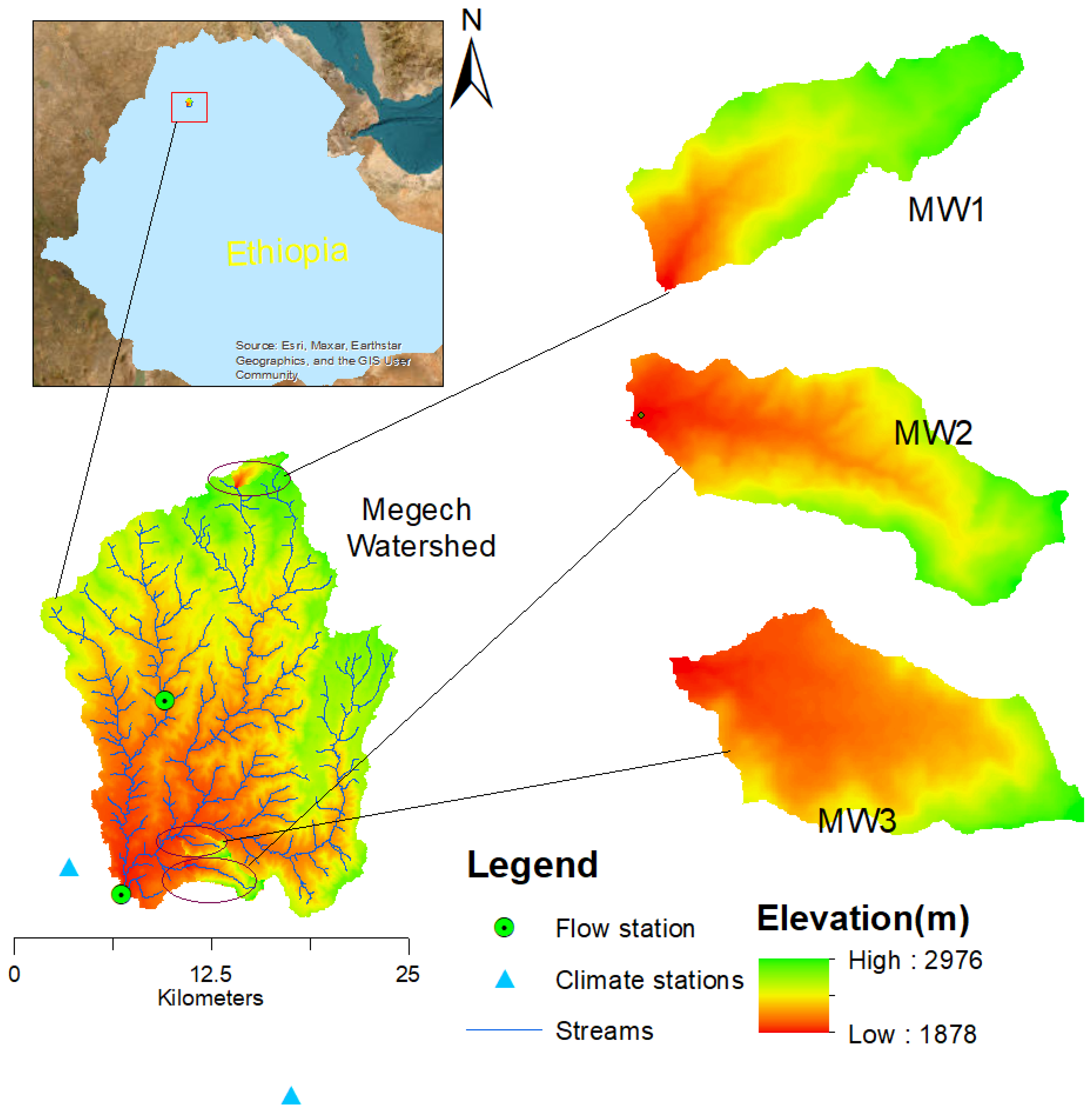
This research was carried out at three specific locations in the Megech dam watershed with an area of 42,400 ha, and discharge of 5.6 m3/s at dam site. Thus, study area is one of the four main sub-watersheds of the Lake Tana Basin. The dam is designed for Gondar town water supply and irrigation purposes with an 864 m crest length, a normal water level (NWL) of 1947.1 m above mean sea level and a volume of 182 million cubic meters (MCM). Sediment trapping efficiency for the reservoir (98% efficiency) showed that in its 50-year lifespan, the reservoir will accumulate 20.3 MCM of sediment volume. However, current studies have indicated that the sediment load in the region is more than the design value mentioned in the design document.
Micro watersheds and plot levels are more accurately predicted by physically based distributed erosion models than large watersheds in terms of soil loss and sediment yield [58]. Therefore, three micro-watersheds named micro-watershed 1 (MW1), micro-watershed 2 (MW2), and micro-watershed 3 (MW3) were identified as hotspot sediment-yielding areas to the Megech dam watershed, which are MW1, located at the north tip, but MW2 and MW3, two adjacent micro-watersheds located in the south direction (Figure 1). Micro-Watershed1 (MW1) has an area of 396.22 ha, of which 52.12% is covered with agricultural land use. Micro-Watershed 2 (MW2) has an area of 684.95 ha, and the cropland coverage is approximately 68% of the sub-watershed. Micro-watershed 3 (MW3) has an area of 380.78 ha; its crop land covers 70.78% of the total area. Megech watershed supports a variety of land use/land cover, crop land (59.31%), grassland (15.4%), forest (7.5%), shrub land (6.8%), woodland (5.8%), and bare land and built-up areas of approximately 2% based on the analysis using the 2016 land use map. In the context of this study, the forest represents land covered with dense trees while woodland represents land with trees dominated by open spaces. Keep in mind that the research area’s primary land use and land cover is crop land, and it is steadily growing. The dominant soil for the selected micro-watersheds for MW1 is Eutric Leptosols (clay loam); for MW2, eutric cambisols (light clay loam); and for MW3, Eutric Leptosols (clay loam).
In the top half watershed, the mean annual precipitation is about 1100 mm, while in the lower part, it is about 1000 mm. The study area’s maximum temperature ranges from 23 °C in July to 30 °C in March, while the lowest temperature varies from 11.5 °C in January to 15.6 °C. From 39% in March to 79% in August, the relative humidity fluctuates. Low wind speeds reduce the possibility of evapotranspiration rates between 101 mm per month in July and 149 mm per month in March. In July and June, the amount of sunshine is decreased to 4.2–4.9 h.
Rill and gully erosion is responsible for the creation of just a small number of shallow seated gullies at reservoir catchments. The watershed is characterized by a high population rate that is anticipated to triple in the next fifty years, a steep slope, historically inadequate land management, and an ongoing destruction of the natural vegetation. As a result of the increased agricultural operations carried out in the watershed, such as steep area farming and aggressive grazing, gullies that directly ran into the Megech river were being produced. The Megech reservoir basin’s geology is dominated by various types of basalt, a minor tuff, consolidated paleosoil, and recent soil cover. Over the reservoir basin’s rocks, a rather thick soil has formed. Major structures in the region are primarily joints, fractures, and minor faults, with dominant and most frequent directions being north–south [59].
2.2. Datasets
In this study, we employed DEM, LULC, soil spatial data, and climate data as GeoWEPP model inputs (see Table 1). Data of streamflow and sediment concentration from Angereb and Megech watershed rivers were used for model calibration and validation.
2.3. Methods
2.3.1. GeoWEPP Modelling
Since this physically based erosion model is free and suitable for natural resource management of smaller watersheds (most suitable 260 ha), GeoWEPP of version for ArcGIS 10.2 and WEPP v2012.8 were chosen for runoff, soil loss, and sediment yield simulation [60]. Topographic Parametrization (TOPAZ) tool to process DEM and generate slope, stream network, and sub-catchments. Utilizing observed precipitation, maximum and minimum temperature in the watershed, Rockclime software was employed to generate climate input data for GeoWEPP. To link the spatial ASCII file with the GEOWEPP model database and execute the WEPP onsite and offsite model simulation, a lookup text file was created for the soil and LULC.
For the purpose of estimating runoff, soil loss, and sediment yield, GeoWEPP modelling was used at the Megech watershed site. Preparing input data for the GeoWEPP model, running the model and calculating soil loss, sediment yield, and runoff. Prior to the model being utilized to forecast soil loss, sediment yield and runoff sensitivity analysis, calibration, and validation were carried out. Simulations were carried out for the present (baseline) state and for evolved scenarios to determine the effectiveness of the implementation of agricultural best land management practices (BMPs). Statistics were utilized to compare the results of the various scenarios with the current results in order to assess the efficiency of the situation. Instead of applying the same BMP scenarios to all regions at erosion-prone locations, each hill slope should receive a different set of BMPs based on the results of the WEPP model, reduced soil loss at a higher percentage and the effectiveness of grass water to reduce runoff and sediment yield [61].
Model Evaluation
The GeoWEPP model simulation performance in the study watershed was checked through sensitivity analysis of parameters such as hydraulic conductivity (K), interrill erodibility (Ki), rill erodibility and critical shear stress (τc) that control the surface runoff, soil loss, and sediment yield rates from the hill slope. After selecting the sensitive parameters, calibration and validation for runoff and sediment yield were performed for the statistical metrics of coefficient of determination, Nash–Sutcliffe, and percent of bias. The performance rating described the model’s replication capacity for the monthly time step for both flow and sediment (Table 2).
2.3.2. Best Management Practice (BMP) Scenario Development
BMP in physically based model applications can improve watershed planning and produce good results in the reduction of soil loss and its influences [63]. In the WEPP database, various cropping and tillage alternatives are available to be considered to reduce the impacts of runoff, soil loss, and sediment yield [64]. Therefore, in the GeoWEPP model environment, scenario development primarily focused on cropping and tillage methods or agronomic BMPs to address the issues of soil loss, sediment yield, and runoff for a specific watershed or hill slope when issues are detected. To examine the effects of the four BMP scenarios on runoff, soil loss, and sediment yield, we simulated the GeoWEPP model under each scenario and the baseline condition.
- BL: baseline or current time situation (conventional tillage);
- Scenario 1 (S1): forest five-year perennial (agroforestry);
- Scenario 2 (S2): corn, soybean, wheat, alfalfa (4 yr) no till;
- Scenario 3 (S3): corn, soybean, wheat, and alfalfa (4 yr) conservation (consv.) Till; consv.—represents agricultural conservation, such as strip cropping;
- Scenario 4 (S4): winter wheat mulch till.
- Scenario One (S1): Forest Five-Year Perennial
In this case, it is assumed that all crop land will be converted to agroforestry, which is described as a “five-year perennial forest” in the GeoWEPP management database alternatives. Slope, soil type, and climate model inputs were left unaffected, while crop land use was changed to forest.
- Scenarios 2 and 3:
Both scenarios “Corn, Soybean, wheat, alfalfa (4 yr) no till” and “Corn, Soybean, wheat, alfalfa (4 yr) cnsv.till” in the model’s management scenario options no till and conservational tillage agriculture system, respectively.
- Scenario 4:
This option is the “winter wheat mulch till” tillage practice with mulching as a soil erosion protection mechanism in the WEPP model environment.
It is important to base decisions on two main factors when selecting micro-watersheds for BMP scenarios. Based on the GeoWEPP model and hotspot sediment yield SY analysis, the first criterion is the sediment yield rates at the reported outlets of micro watersheds. The percentage of farmland in the micro-watershed is the second criterion since this land use is a significant source of soil erosion and sediment transport. It is ideal to use structural BMPs and the vegetative BMPs available in the field to control soil erosion [65,66]. Soil conservation structures and best management practices keep the sediment on the field to protect dam reservoir siltation and retain soil nutrients for crop production. Once sediment leaves a site, it is no longer considered a valuable resource; instead, it is considered a pollutant.
3. Results
3.1. Model Performance Measure
Statistical model evaluation indicators, including the coefficient of determination, Nash–Sutcliffe efficiency, and percent bias metrics, were used to evaluate the performance of the model. Since continuous and detailed spatial and temporal scale data are scarce in the study area, monthly time step flow and sediment data are used for model evaluation. Calibration (2000–2002) and validation (2003–2004) of the model was performed and provided acceptable performance [62]. Model performance results were achieved by using manual calibration for soil sensitive parameters in monthly time steps (see Table 3). The GeoWEPP model was calibrated and validated for runoff and sediment yield to check how the model simulation repeated the observed values at the Angereb sub-watershed and resulted in acceptable performance.
3.1.1. Soil Loss
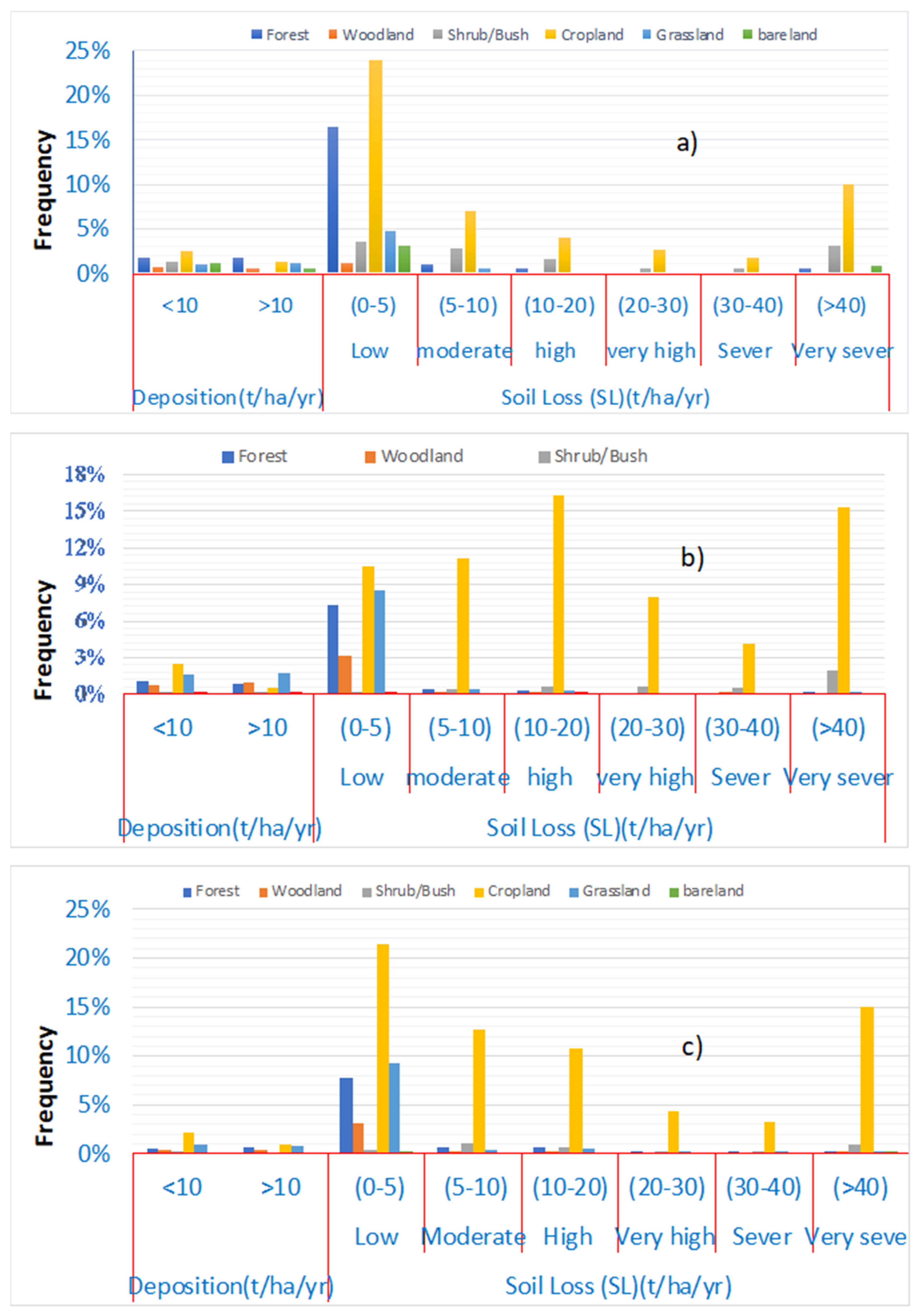
The frequency distribution of soil loss rates with regard to the various land use types for conventional tillage conditions was presented using the onsite GeoWEPP model simulation for the selected three micro-watersheds (Figure 2). The findings showed that across the micro-watersheds, soil loss rates varied significantly by land use/land cover types, with a higher proportion occurring on cropland due to its area coverage and sources of higher rates of erosion in terms of severity. The larger share comes from crop land regions as the severity of soil erosion increases through (0–5) low, (5–10) moderate, (10–20) high, (20–30) very high, (30–40) severe, and >40 t/ha/year—extremely severe; nevertheless, the severity proportion is variable among the micro-watersheds. The conclusion suggests that implementing the intended BMP scenarios for croplands could result in positive outcomes to lessen soil losses from the watershed.
3.1.2. Onsite Hill Slope Analysis
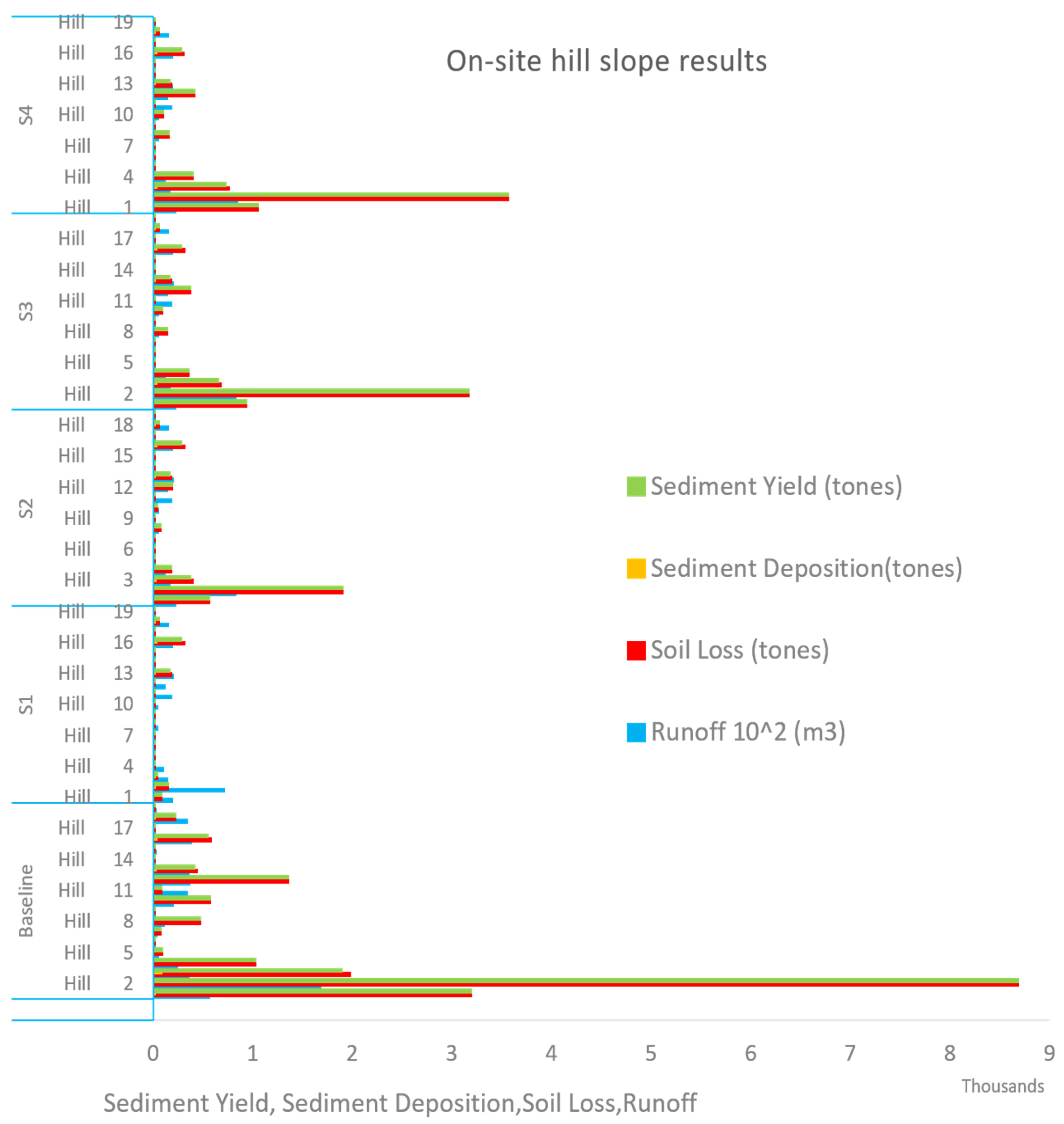
Micro-watershed 1 (MW1), with an area of 366.22 ha, was redeliberated using TOPAZ software with a critical source area (CSA) of 25 ha and a minimum source channel length (MSCL) of 150 m to change hill slopes from 96 to 18 to visualize the changes in runoff, soil loss, and sediment yield across the selected BMP scenarios. Runoff, soil loss and sediment yield were reduced for S1, S2, S3, and S4 every hill slope (see Figure 3). It can be observed that such analysis provides an advantage of planning and implementing BMPs prioritized at hill slope levels.
Runoff, soil loss, sediment yield, and deposition estimation indicated considered BMP; scenarios S1, S2, S3, and S4 impacted every hill slope to reduce runoff, soil loss, and sediment yield. Because the reduction level varies with the hill slopes, the GeoWEPP model provides the opportunity to implement BMPs at selected hill slopes to be more economical (see Figure 3).
3.1.3. Sediment Yield
After model calibration and validation, it was employed to estimate runoff, soil loss and sediment yield at sub-watersheds, micro-watersheds, and hill slopes. The three identified micro-watersheds had the highest mean annual sediment yield simulated for the baseline (conventional tillage practice) (Table 4). The average annual sediment yield ranges between 10.3 and 54.8 t/ha/year for the sub-watersheds of the Megech watershed, with a mean value of 28.57 t/ha/year; the highest values were taken to assess the impacts of BMP.
Based on the selection criteria of cropland and sediment yielding rate, micro-watersheds of crop land areas greater than 50% and hot sediment yielding rates MW1, MW2, and MW3 were selected. The selected micro-watershed yields were significantly higher than the desired or acceptable sediment yield value (10 t/ha/year) in the upper Blue Nile Basin (Table 4). According to previous studies [67,68], the tolerable soil erosion rates or target value (T) for the region is 10 t/ha/year.
3.2. Best Management Practice (BMP) Scenarios and Impacts
GeoWEPP model simulation was performed for the four best management practice scenarios and the baseline (conventional tillage of cultivated lands) to estimate soil loss, sediment yield and runoff for three micro-watersheds in the Megech watershed. Impact assessment of implementing BMP scenarios expressed as a percent change with respect to the current condition. It is negative if
where YBMP indicates estimated value at best management practice scenario values; YBaseline indicates estimated value at baseline condition; and %Δ represents change.
3.2.1. Runoff Reduction
The average annual surface runoff volume decreased with values ranging between 2.95 and 32.59% for the five-year forest perennial scenario (S1). The no till (S2) and conservation till (S3) scenarios depicted similar trends in surface runoff reduction compared to the conventional till scenario; however, in the case of the winter wheat mulch till scenario, runoff increased for MW1 and MW3 and decreased for MW2 (Table 5). Applying mulching mostly delays flow time and increased infiltration to reduced runoff, but when soils are compacted and low infiltration capacity mulching increases runoff for MW1 and MW3 due to soil type differences [69].
3.2.2. Soil Loss and Sediment Yield Reduction
The watershed method simulation for the baseline and BMPs illustrated that soil loss at hill slopes decreased with ranges between 6.73 and 93.52% for the three micro-watersheds BMPs implemented; for channels, this value varied between 20.83 and 94.19%. The sediment yield (SY) per unit area, collected from the hill slopes to the channel and transported to the outlet through channel routing, decreased by 15.34 to 92.52%. Such a reduction in soil loss was recorded for all three micro-watersheds and across four BMPs. The highest reduction percentage was observed for the first scenario (S1), forest five-year perennial, implying that this scenario is the most effective scenario compared to the others (Table 6).
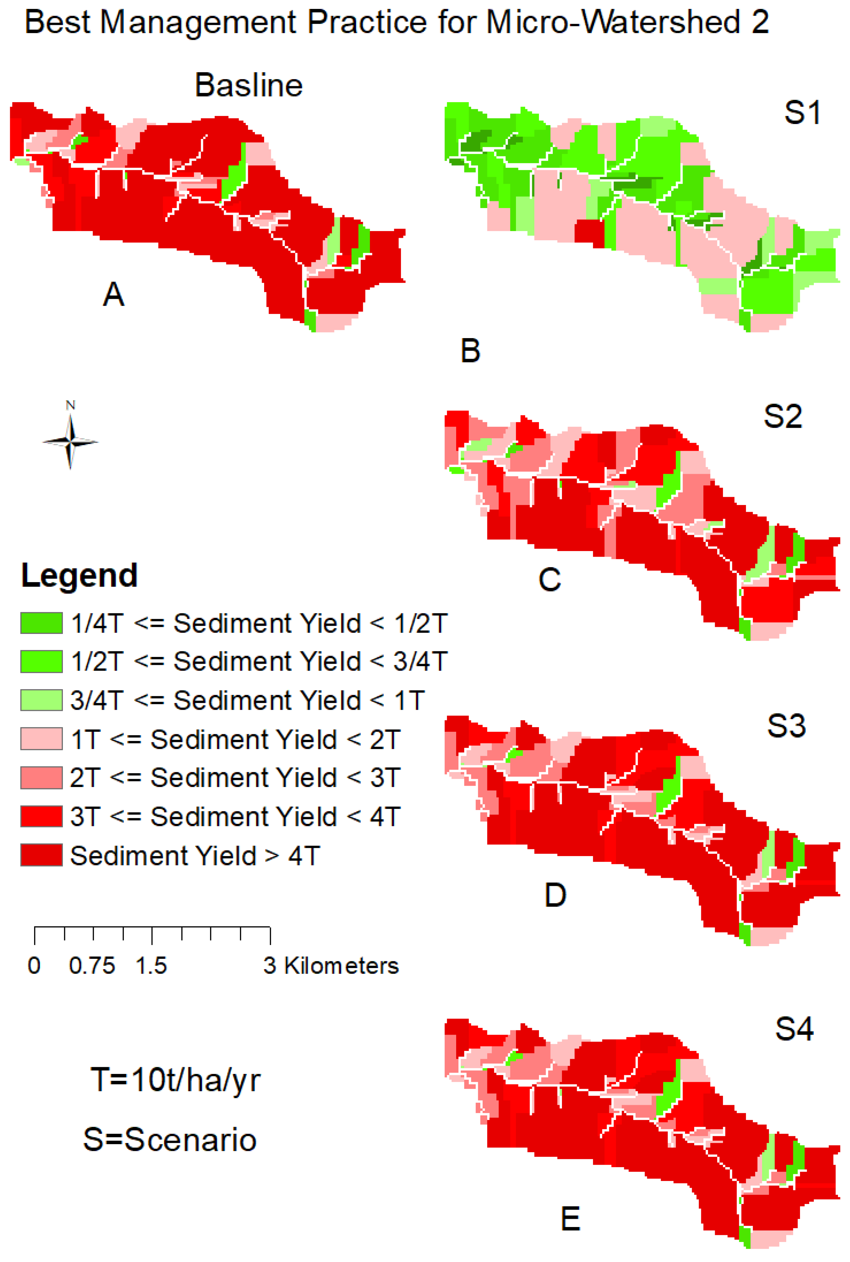
Figure 4, Figure 5 and Figure 6 present the average annual sediment yield values relative to the tolerable soil loss (10 t/ha/year) for the four considered BMPs and baseline scenarios. The green color indicates sediment yields under the tolerable range, while the red color sediment yields greater than the tolerable value. For scenario 1 (forestry), sediment yield is below the tolerable rates in most of the area with SY < 5 t/ha/year. In scenarios 2, 3 and 4, sediment yield is reduced compared to the baseline but still above the tolerable rates. This shows that scenario 1 is best at trapping sediments and protecting reservoir siltation.
The annual average sediment yield distribution delivered to the outlets collected from the hill slopes entered the channel and reached the outlet after the channel sediment routing of micro-watersheds; MW1, MW2, and MW3 were computed using the GeoWEP model, and the results were mapped (see Figure 4, Figure 5 and Figure 6).
4. Discussion
4.1. Modelling of Runoff, Soil Loss, and Sediment Yield
Modelling runoff, soil loss, and sediment yield at the watershed scale in data-scarce areas such as the upper Blue Nile Basin is very challenging [70]. The model simulated weighted mean runoff depths over three micro-watersheds was estimated to be 238.77 mm; less than 282 mm, estimated by Assfaw [71], using the SWAT model; and also from 416.8 mm including baseflow [59]. This implied that GeoWEPP model underestimated the annual runoff of the Megech watershed.
In this study, sediment yield rates were estimated to be in the range between 10.3 and 54.8 t/ha/year with an average value of 28.57 t/ha/year. This result is in line with previous study reports [72]. For instance, values between 5 and 25 t/ha/year and a mean of 19.5 t/ha/year were reported in the Andasa watershed. Studies in northwestern Ethiopia (Anjeb watershed) revealed SY rates ranging between 2.5 and 157 t/ha/year, higher than the value in this study with a smaller mean value [73]. The bathymetric approach combined with modelling to estimate the SY rate of the Abrajit reservoir was estimated as 47.33 t/ha/year [74]; previous studies reviewing Ethiopia [75] revealed a sediment yield rate value of 26 t/ha/year and a sediment yield rate value of 36.47 t/ha/year in the Fincha watershed [15].
Soil loss rates have also been reported by different researchers. For instance, Endalamaw et al. [76] reported soil loss rates of 28.68 t/ha/year in the Gilgel Beles, upper Blue Nile; Sinshaw et al. [16] reported a value of 23.53 t/ha/year in the Rib watershed; and Getnet and Mulu [77] estimated a soil loss value of 27.7 t/ha/year in the Jedeb watershed. Sediment yield and soil loss estimation in the Megech watershed showed high spatial variability, which helps to apply BMPs at the hill slope and sub-watershed levels.
4.2. BMP Impacts on Runoff, Soil Loss, and Sediment Yield
The GeoWEPP model was used to evaluate the anticipated changes in runoff, soil loss and sediment yield due to the application of agricultural BMP scenarios. The application of alternative BMP scenarios for the crop lands of all three watersheds was to compare and identify that the most reduced soil loss, runoff, and sediment yields [78]. GeoWEPP model simulations for annual runoff, soil loss, and sediment yield quantified for more than ten years since long-term (>eight years) simulation results are more consistent than short-term simulations [57]. At the selected micro-watersheds in the study area, the percent reduction in the runoff, sediment yield (SY), hill slope soil loss, and channel soil loss ranges between 0.99 to 13.68%, 51.72 to 88.73%, 18 to 86.17%, and 49.5 to 86.27%, respectively, for the selected BMP scenarios compared to the baseline scenario. In the highlands of Ethiopian watersheds, the application of vegetative BMPs such as contour strips reduces soil loss rates by 63.9% [15], which is in line with the results of this study.
In general, the S1, S2, S3, and S4 BMP options for agricultural land use type reduced runoff, soil erosion, and sediment yield. In this study, structural BMPs were not included since the GeoWEPP model has no such packages and focuses on agricultural options in its management database. However, ref. [18] justified that the GeoWEPP model is an important tool for assessing how soil and water conservation (SWC) structures work to lower soil loss rates in the watershed with long period measurement data in preparing slope changes due to structures.
Figure 7 depicts the effects of BMP scenarios at the micro-watersheds compared to the baseline scenario in terms of the weighted mean for the micro-watersheds. The highest impact was from the application of forestry, while the lowest change was from winter wheat mulch until the scenario for all SL, runoff, and SY. The sediment yield percent reduction for alternative BMPs varied from 85.3% to 92.5% under the forest five-year perennial (S1); from 56.16 to 78.34% for corn, soybean, wheat, and alfalfa (4 yr) no till (S2); and 56.16 to 67.89% under corn, soybean, wheat, and alfalfa (4 yr) consv. Till (S3); and from 15.34 to 68.86% under the winter wheat mulch till (S4) scenarios. The lowest sediment reduction rate was observed at 15.34% for MW3 under mulch till conditions. With a high percentage of reduction (85.3% to 92.5%) in the forest five-year perennial scenario, MW1, MW2, and MW3 produced 4.1, 7.6, and 2.8 t/ha/year, respectively, and 6 t/h/year was less than the allowable SY (10 t/ha/year). Figure 7 shows the quantitative estimation of sediment yield, its distribution and a comparison of the baseline and four BMP scenarios.
4.3. Benefits of BMPs and Implementation Challenges
The high rates of soil erosion in the upper Blue Nile Basin (UBN) are caused by an unmanaged agriculture system and high population stress, which necessitates land management practices and/or structural erosion controls to mitigate the impact on soil productivity and reservoir sedimentation. Application of the GeoWEPP model to evaluate runoff, soil loss, and sediment yield provides an advantage of knowing the degree of seriousness onsite soil and sediment yield at the outlets as per users’ criteria or the target value in the area and provides maps of SL and SY relative to targeted values flexibility to assess BMPs [57,63]. Afforestation and conservation tillage scenarios are known economical BMPs applied to agricultural lands, while the no-tillage practice option is an environmentally friendly scenario [79]. Mulches can provide advantages of reducing soil evaporation, can be applied at varying land scape and different stresses of agriculture, and are economical [80]. Therefore, agricultural BMPs can provide many benefits for watersheds where more than 57% is crop land, varying slope soil labelled as high soil loss, and sediment yield areas.
5. Conclusions
This study’s findings illustrated that geospatially distributed GeoWEPP model approach by applying alternative vegetative BMP scenarios in addition to conventional tillage (baseline scenario) can measure the effectiveness to reduce runoff, soil loss, and sediment yield in the Megech watershed, upper Blue Nile Basin, a region with limited data and economic constraints. To estimate runoff, soil loss, and sediment that varied spatially across the channels, sub-watersheds and hill slopes, a calibrated and validated GeoWEPP model was utilized. To identify the effects of implementing BMPs on runoff, soil loss, and sediment yield compared to the baseline scenario, three hotspot high-sediment-yielding micro-watersheds were selected. The results indicated that all BMPs—scenario 1 (S1), forest five years perennial (agroforestry); scenario 2 (S2), corn, soybean, wheat, alfalfa (4 yr) no till; scenario 3 (S3), corn, soybean, wheat, alfalfa (4 yr) consv. till; and scenario 4 (S4), winter wheat mulch till—reduced soil loss and sediment yield at all micro-watersheds. The application of scenario 1 with highest impact can reduce in average runoff, soil loss, and sediment yield with 13.68%, 86.27%, and 88.73%, respectively, while scenario 4’s lowest reduction percentages were 0.99%, 18.0%, and 51.72% for runoff, hill soil loss, and sediment yield, respectively. In general, studied BMP scenarios significantly reduced surface runoff, SL, and SY compared to the conventional tillage practice of the watershed, implying that implementation through farmer participation is worth protecting Megech dam reservoir from silt upstream watershed and maintaining land degradation. Of all four BMP scenarios applied in the crop lands, the forest five-year perennial (S1) performed best in the reduction of runoff, channel, and hill slope SL, and SY, indicating that the agroforestry option is effective in controlling cultivated lands. However, studies have indicated that structural BMPs are better at reducing SY, so further investigation including structural options is very important.
In general, this study made great effort to identify hotspot soil erosion and sediment yield areas by applying BMP alternative scenarios in the GeoWEPP model environment to check how SY, SL, and runoff responded across the scenarios with respect to the baseline model results. This study employed agricultural BMPs in crop land areas, and future researches should be conducted by incorporating structural BMPs. Additionally, cost-benefit analysis was not included in the research work and shall be the focus of future research.
Author Contributions
Conceptualization, M.A. and A.M.M.; methodology, M.A.; software, M.A.; validation, M.A.; formal analysis, M.A.; investigation, M.A.; data curation, M.A.; writing—original draft preparation, M.A.; writing—review and editing, M.A., G.T., A.M.M., G.T. and B.A.; visualization, M.A.; supervision, A.M.M. and B.A.; funding acquisition, M.A. All authors have read and agreed to the published version of the manuscript.
Funding
The first author recognizes the fund provided by the Ministry of Education (MoE) of Ethiopia for the doctoral research.
Data Availability Statement
Data can be obtained at the request of the corresponding author.
Acknowledgments
The authors would like to thank the data providers, the Ministry of Water and Energy (MoWE), the Abbay Basin Authority (ABA), Water and Land Resources Center (WLRC), and the National Meteorological Agency (NMA). The authors express their sincere thanks to reviewers and the editor for their comments to improve publication quality.
Conflicts of Interest
The authors declare that there are no known competing financial interests or personal relationships that could have appeared to influence the work reported in this paper.
References
- Brunner, A.; Park, S.; Ruecker, G.; Vlek, P. Erosion modelling approach to simulate the effect of land management options on soil loss by considering catenary soil development and farmers perception. Land Degrad. Dev. 2008, 19, 623–635. [Google Scholar] [CrossRef]
- Vagen, T.G.; Winowiecki, L.A. Predicting the Spatial Distribution and Severity of Soil Erosion in the Global Tropics using Satellite Remote Sensing. Remote Sens. 2019, 11, 1800. [Google Scholar] [CrossRef] [PubMed] [Green Version]
- Haregeweyn, N.; Tsunekawa, A.; Poesen, J.; Tsubo, M.; Meshesha, D.T.; Fenta, A.A.; Nyssen, J.; Adgo, E. Comprehensive assessment of soil erosion risk for better land use planning in river basins: Case study of the Upper Blue Nile River. Sci. Total Environ. 2017, 574, 95–108. [Google Scholar] [CrossRef] [PubMed] [Green Version]
- Li, P.; He, Z.; Cai, J.; Zhang, J.; Belete, M.; Deng, J.; Wang, S. Identify the Impacts of the Grand Ethiopian Renaissance Dam on Watershed Sediment and Water Yields Dynamics. Sustainability 2022, 14, 7590. [Google Scholar] [CrossRef]
- Aristeidis, K.; Dimitrios, S. The effect of small earth dams and reservoirs on water management in North Greece (Kerkini municipality). Silva Balc. 2015, 16, 71–84. [Google Scholar]
- Mugabe, F.T.; Hodnett, M.; Senzanje, A. Opportunities for increasing productive water use from dam water: A case study from semi-arid Zimbabwe. Agric. Water Manag. 2003, 62, 149–163. [Google Scholar] [CrossRef]
- Ewunetu, A.; Simane, B.; Teferi, E.; Zaitchik, B.F. Mapping and quantifying comprehensive land degradation status using spatial multicriteria evaluation technique in the headwaters area of Upper Blue Nile River. Sustainability 2021, 13, 2244. [Google Scholar] [CrossRef]
- Awulachew, S.B.; Tenaw, M. Micro Watershed to Basin Scale Impacts of Widespread Adoption of Watershed Management Interventions in Blue Nile Basin. 2008. Available online: https://ideas.repec.org/p/iwt/conppr/h041747.html (accessed on 13 February 2023).
- McElwee, P.; Calvin, K.; Campbell, D.; Cherubini, F.; Grassi, G.; Korotkov, V.; Le Hoang, A.; Lwasa, S.; Nkem, J.; Nkonya, E. The impact of interventions in the global land and agri-food sectors on Nature’s Contributions to People and the UN Sustainable Development Goals. Glob. Change Biol. 2020, 26, 4691–4721. [Google Scholar] [CrossRef]
- Adimassu, Z.; Langan, S.; Barron, J. Highlights of Soil and Water Conservation Investments in Four Regions of Ethiopia; International Water Management Institute (IWMI): Colombo, Sri Lanka, 2018; Volume 182. [Google Scholar] [CrossRef] [Green Version]
- Lal, R. Soil conservation and ecosystem services. Int. Soil Water Conserv. Res. 2014, 2, 36–47. [Google Scholar] [CrossRef] [Green Version]
- Li, P.; Muenich, R.L.; Chaubey, I.; Wei, X. Evaluating agricultural BMP effectiveness in improving freshwater provisioning under changing climate. Water Resour. Manag. 2019, 33, 453–473. [Google Scholar] [CrossRef]
- Yibeltal, M.; Tsunekawa, A.; Haregeweyn, N.; Meshesha, D.T.; Billi, P.; Bedaso, Z.; Wubet, A.; Kang, M.W.; Lee, S.S. Effect of exclosure on subsurface water level and sediment yield in the tropical highlands of Ethiopia. J. Environ. Manag. 2022, 317, 115414. [Google Scholar] [CrossRef] [PubMed]
- Ali, M.G.; Ali, S.; Arshad, R.H.; Nazeer, A.; Waqas, M.M.; Waseem, M.; Aslam, R.A.; Cheema, M.J.M.; Leta, M.K.; Shauket, I. Estimation of potential soil erosion and sediment yield: A case study of the transboundary Chenab River Catchment. Water 2021, 13, 3647. [Google Scholar] [CrossRef]
- Dibaba, W.T.; Demissie, T.A.; Miegel, K. Prioritization of sub-watersheds to sediment yield and evaluation of best management practices in highland Ethiopia, finchaa catchment. Land 2021, 10, 650. [Google Scholar] [CrossRef]
- Sinshaw, B.G.; Belete, A.M.; Mekonen, B.M.; Wubetu, T.G.; Anley, T.L.; Alamneh, W.D.; Atinkut, H.B.; Gelaye, A.A.; Bilkew, T.; Tefera, A.K. Watershed-based soil erosion and sediment yield modeling in the Rib watershed of the Upper Blue Nile Basin, Ethiopia. Energy Nexus 2021, 3, 100023. [Google Scholar] [CrossRef]
- Damtie, B.B.; Mengistu, D.A.; Waktola, D.K.; Meshesha, D.T. Impacts of Soil and Water Conservation Practice on Soil Moisture in Debre Mewi and Sholit Watersheds, Abbay Basin, Ethiopia. Agriculture 2022, 12, 417. [Google Scholar] [CrossRef]
- Abiye, W. Soil and Water Conservation Nexus Agricultural Productivity in Ethiopia. Adv. Agric. 2022, 2022, 8611733. [Google Scholar] [CrossRef]
- Masha, M.; Yirgu, T.; Debele, M. Impacts of Soil and Water Management Measures on Crop Production and Farm Income of Rural Households in the Damota Area Districts, Southern Ethiopia. Int. J. Agron. 2021, 2021, 5526713. [Google Scholar] [CrossRef]
- Melaku, N.D.; Renschler, C.S.; Flagler, J.; Bayu, W.; Klik, A. Integrated impact assessment of soil and water conservation structures on runoff and sediment yield through measurements and modeling in the Northern Ethiopian highlands. Catena 2018, 169, 140–150. [Google Scholar] [CrossRef]
- Tesfayohannes, S.; Kassa, G.; Mulat, Y. Impact of soil and water conservation practices on crop income in tembaro district, southern Ethiopia. Heliyon 2022, 8, e10126. [Google Scholar] [CrossRef]
- Biratu, A.A.; Bedadi, B.; Gebrehiwot, S.G.; Melesse, A.M.; Nebi, T.H.; Abera, W.; Tamene, L.; Egeru, A. Impact of Landscape Management Scenarios on Ecosystem Service Values in Central Ethiopia. Land 2022, 11, 1266. [Google Scholar] [CrossRef]
- Dibaba, W.T.; Demissie, T.A.; Miegel, K. Drivers and implications of land use/land cover dynamics in Finchaa catchment, northwestern Ethiopia. Land 2020, 9, 113. [Google Scholar] [CrossRef] [Green Version]
- Moges, M.M.; Abay, D.; Engidayehu, H. Investigating reservoir sedimentation and its implications to watershed sediment yield: The case of two small dams in data-scarce upper Blue Nile Basin, Ethiopia. Lakes Reserv. Res. Manag. 2018, 23, 217–229. [Google Scholar] [CrossRef]
- Maina, C.W.; Sang, J.K.; Mutua, B.M.; Raude, J.M. A review of radiometric analysis on soil erosion and deposition studies in Africa. Geochronometria 2018, 45, 10–19. [Google Scholar] [CrossRef] [Green Version]
- Endalew, L.; Mulu, A. Estimation of reservoir sedimentation using bathymetry survey at Shumburit earth dam, East Gojjam zone Amhara region, Ethiopia. Heliyon 2022, 8, e11819. [Google Scholar] [CrossRef]
- Haregeweyn, N.; Melesse, B.; Tsunekawa, A.; Tsubo, M.; Meshesha, D.; Balana, B.B. Reservoir sedimentation and its mitigating strategies: A case study of Angereb reservoir (NW Ethiopia). J. Soils Sediments 2012, 12, 291–305. [Google Scholar] [CrossRef]
- Mekonnen, M.; Keesstra, S.; Baartman, J.; Ritsema, C.; Melesse, A. Evaluating sediment storage dams: Structural off-site sediment trapping measures in northwest Ethiopia. Cuad. Investig. Geogr. 2015, 41, 7–22. [Google Scholar] [CrossRef] [Green Version]
- Sojka, M.; Jaskuła, J.; Siepak, M. Heavy metals in bottom sediments of reservoirs in the lowland area of western Poland: Concentrations, distribution, sources and ecological risk. Water 2018, 11, 56. [Google Scholar] [CrossRef] [Green Version]
- Zhou, Z.; Wang, Y.; Teng, H.; Yang, H.; Liu, A.; Li, M.; Niu, X. Historical evolution of sources and pollution levels of heavy metals in the sediment of the Shuanglong Reservoir, China. Water 2020, 12, 1855. [Google Scholar] [CrossRef]
- Patro, E.R.; De Michele, C.; Granata, G.; Biagini, C. Assessment of current reservoir sedimentation rate and storage capacity loss: An Italian overview. J. Environ. Manag. 2022, 320, 115826. [Google Scholar] [CrossRef]
- Ebabu, K.; Tsunekawa, A.; Haregeweyn, N.; Adgo, E.; Meshesha, D.T.; Aklog, D.; Masunaga, T.; Tsubo, M.; Sultan, D.; Fenta, A.A. Analyzing the variability of sediment yield: A case study from paired watersheds in the Upper Blue Nile basin, Ethiopia. Geomorphology 2018, 303, 446–455. [Google Scholar] [CrossRef]
- Liu, X.; Xin, L.; Lu, Y. National scale assessment of the soil erosion and conservation function of terraces in China. Ecol. Indic. 2021, 129, 107940. [Google Scholar] [CrossRef]
- Margiorou, S.; Kastridis, A.; Sapountzis, M. Pre/Post-Fire Soil Erosion and Evaluation of Check-Dams Effectiveness in Mediterranean Suburban Catchments Based on Field Measurements and Modeling. Land 2022, 11, 1705. [Google Scholar] [CrossRef]
- Zema, D.A.; Carrà, B.G.; Lucas-Borja, M.E.; Filianoti, P.G.F.; Pérez-Cutillas, P.; Conesa-García, C. Modelling Water Flow and Soil Erosion in Mediterranean Headwaters (with or without Check Dams) under Land-Use and Climate Change Scenarios Using SWAT. Water 2022, 14, 2338. [Google Scholar] [CrossRef]
- Gebrernichael, D.; Nyssen, J.; Poesen, J.; Deckers, J.; Haile, M.; Govers, G.; Moeyersons, J. Effectiveness of stone bunds in controlling soil erosion on cropland in the Tigray Highlands, northern Ethiopia. Soil Use Manag. 2005, 21, 287–297. [Google Scholar] [CrossRef]
- Mekonnen, M.; Getahun, M. Soil conservation practices contribution in trapping sediment and soil organic carbon, Minizr watershed, northwest highlands of Ethiopia. J. Soils Sediments 2020, 20, 2484–2494. [Google Scholar] [CrossRef]
- Belayneh, M.; Yirgu, T.; Tsegaye, D. Runoff and soil loss responses of cultivated land managed with graded soil bunds of different ages in the Upper Blue Nile basin, Ethiopia. Ecol. Process. 2020, 9, 1–18. [Google Scholar] [CrossRef]
- Uniyal, B.; Jha, M.K.; Verma, A.K.; Anebagilu, P.K. Identification of critical areas and evaluation of best management practices using SWAT for sustainable watershed management. Sci. Total Environ. 2020, 744, 140737. [Google Scholar] [CrossRef]
- Amare, T.; Zegeye, A.D.; Yitaferu, B.; Steenhuis, T.S.; Hurni, H.; Zeleke, G. Combined effect of soil bund with biological soil and water conservation measures in the northwestern Ethiopian highlands. Ecohydrol. Hydrobiol. 2014, 14, 192–199. [Google Scholar] [CrossRef]
- Bombino, G.; Denisi, P.; Gómez, J.A.; Zema, D.A. Mulching as best management practice to reduce surface runoff and erosion in steep clayey olive groves. Int. Soil Water Conserv. Res. 2021, 9, 26–36. [Google Scholar] [CrossRef]
- Mupangwa, W.; Yahaya, R.; Tadesse, E.; Ncube, B.; Mutenje, M.; Chipindu, L.; Mhlanga, B.; Kassa, A. Crop productivity, nutritional and economic benefits of no-till systems in smallholder farms of Ethiopia. Agronomy 2023, 13, 115. [Google Scholar] [CrossRef]
- Komissarov, M.; Klik, A. The impact of no-till, conservation, and conventional tillage systems on erosion and soil properties in Lower Austria. Eurasian Soil Sci. 2020, 53, 503–511. [Google Scholar] [CrossRef]
- Yadav, G.S.; Das, A.; Lal, R.; Babu, S.; Datta, M.; Meena, R.S.; Patil, S.B.; Singh, R. Impact of no-till and mulching on soil carbon sequestration under rice (Oryza sativa L.)-rapeseed (Brassica campestris L. var. rapeseed) cropping system in hilly agro-ecosystem of the Eastern Himalayas, India. Agric. Ecosyst. Environ. 2019, 275, 81–92. [Google Scholar] [CrossRef]
- Chen, X.; Liang, Z.; Zhang, Z.; Zhang, L. Effects of soil and water conservation measures on runoff and sediment yield in red soil slope farmland under natural rainfall. Sustainability 2020, 12, 3417. [Google Scholar] [CrossRef] [Green Version]
- Desta, G.; Tamene, L.; Abera, W.; Amede, T.; Whitbread, A. Effects of land management practices and land cover types on soil loss and crop productivity in Ethiopia: A review. Int. Soil Water Conserv. Res. 2021, 9, 544–554. [Google Scholar] [CrossRef]
- Du, X.; Jian, J.; Du, C.; Stewart, R.D. Conservation management decreases surface runoff and soil erosion. Int. Soil Water Conserv. Res. 2022, 10, 188–196. [Google Scholar] [CrossRef]
- Gashaw, T.; Dile, Y.T.; Worqlul, A.W.; Bantider, A.; Zeleke, G.; Bewket, W.; Alamirew, T. Evaluating the effectiveness of best management practices on soil erosion reduction using the SWAT Model: For the case of Gumara watershed, Abbay (Upper Blue Nile) Basin. Environ. Manag. 2021, 68, 240–261. [Google Scholar] [CrossRef]
- Berihun, M.L.; Tsunekawa, A.; Haregeweyn, N.; Tsubo, M.; Fenta, A.A.; Ebabu, K.; Sultan, D.; Dile, Y.T. Reduced runoff and sediment loss under alternative land capability-based land use and management options in a sub-humid watershed of Ethiopia. J. Hydrol. Reg. Stud. 2022, 40, 100998. [Google Scholar] [CrossRef]
- Gashaw, T.; Worqlul, A.W.; Dile, Y.T.; Addisu, S.; Bantider, A.; Zeleke, G. Evaluating potential impacts of land management practices on soil erosion in the Gilgel Abay watershed, upper Blue Nile basin. Heliyon 2020, 6, e04777. [Google Scholar] [CrossRef]
- Maalim, F.K.; Melesse, A.M.; Belmont, P.; Gran, K.B. Modeling the impact of land use changes on runoff and sediment yield in the Le Sueur watershed, Minnesota using GeoWEPP. Catena 2013, 107, 35–45. [Google Scholar] [CrossRef]
- Reza Meghdadi, A. Identification of effective best management practices in sediment yield diminution using GeoWEPP: The Kasilian watershed case study. Environ. Monit. Assess. 2013, 185, 9803–9817. [Google Scholar] [CrossRef]
- Narimani, R.; Erfanian, M.; Nazarnejad, H.; Mahmodzadeh, A. Evaluating the impact of management scenarios and land use changes on annual surface runoff and sediment yield using the GeoWEPP: A case study from the Lighvanchai watershed, Iran. Environ. Earth Sci. 2017, 76, 1–15. [Google Scholar] [CrossRef]
- Nut, N.; Mihara, M.; Jeong, J.; Ngo, B.; Sigua, G.; Prasad, P.V.; Reyes, M.R. Land use and land cover changes and its impact on soil erosion in Stung Sangkae catchment of Cambodia. Sustainability 2021, 13, 9276. [Google Scholar] [CrossRef]
- Pandey, A.; Chowdary, V.; Mal, B.; Billib, M. Application of the WEPP model for prioritization and evaluation of best management practices in an Indian watershed. Hydrol. Process. Int. J. 2009, 23, 2997–3005. [Google Scholar] [CrossRef]
- Dutal, H.; Reis, M. Identification of priority areas for sediment yield reduction by using a GeoWEPP-based prioritization approach. Arab. J. Geosci. 2020, 13, 1–11. [Google Scholar] [CrossRef]
- Renschler, C.; Lee, T. Assessing the Long-term Effectiveness of Multiple BMP Settings in Agricultural Watersheds using a GeoWEPP-SWAT Linkage. In Proceedings of the Watershed Management to Meet Water Quality Standards and Emerging TMDL, Atlanta, GA, USA, 5–9 March 2005; p. 380. [Google Scholar] [CrossRef]
- Pandey, A.; Himanshu, S.K.; Mishra, S.K.; Singh, V.P. Physically based soil erosion and sediment yield models revisited. Catena 2016, 147, 595–620. [Google Scholar] [CrossRef]
- WWDSE. Water Works Design and Supervision Enterprize (WWDSE) Megech Dam Detail Design Document. Addis Abeba, Ethiopia. 2009, VI. Available online: https://addisbiz.com/business-directory/11316-water-works-design-supervision-enterprise-wwdse (accessed on 20 March 2020).
- Renschler, C.S.; Flanagan, D.C.; Engel, B.A.; Frankenberger, J.R. GeoWEPP—The geo-spatial interface for the Water Erosion Prediction Project. In Proceedings of the 2002 ASAE Annual Meeting, Chicago, IL, USA, 18–31 July 2002; p. 1. [Google Scholar] [CrossRef] [Green Version]
- Dermisis, D.; Abaci, O.; Papanicolaou, A.; Wilson, C. Evaluating grassed waterway efficiency in southeastern Iowa using WEPP. Soil Use Manag. 2010, 26, 183–192. [Google Scholar] [CrossRef]
- Moriasi, D.N.; Arnold, J.G.; Van Liew, M.W.; Bingner, R.L.; Harmel, R.D.; Veith, T.L. Model evaluation guidelines for systematic quantification of accuracy in watershed simulations. Trans. ASABE 2007, 50, 885–900. [Google Scholar] [CrossRef]
- Brooks, E.; Saia, S.; Boll, J.; Wetzel, L.; Easton, Z.; Steenhuis, T. Assessing BMP Effectiveness and Guiding BMP Planning Using Process-Based Modeling. J. Am. Water Resour. Assoc. 2015, 51, 343–358. [Google Scholar] [CrossRef]
- Ghidey, F.; Alberts, E. Runoff and soil losses as affected by corn and soybean tillage systems. J. Soil Water Conserv. 1998, 53, 64–70. [Google Scholar]
- Anteneh, Y.; Alamirew, T.; Zeleke, G.; Kassawmar, T. Modeling runoff-sediment influx responses to alternative BMP interventions in the Gojeb watershed, Ethiopia, using the SWAT hydrological model. Environ. Sci. Pollut. Res. 2022, 1–19. [Google Scholar] [CrossRef]
- Dibaba, W.T.; Ebsa, D.G. The Status of Soil Erosion in the Upper Blue Nile Basin: Identification of Hot Spot Areas and Evaluation of Best Management Practices in the Toba Watershed. 2021. Available online: https://europepmc.org/article/ppr/ppr390719 (accessed on 13 February 2023).
- Hurni, H. Erosion-productivity-conservation systems in Ethiopia. In Proceedings of the IV International Conference on Soil Conservation. Soil Conservation and Productivity, Maracay, Venezuela, 3–9 November 1985. [Google Scholar] [CrossRef]
- Mwendera, E.; Saleem, M.M.; Dibabe, A. The effect of livestock grazing on surface runoff and soil erosion from sloping pasture lands in the Ethiopian highlands. Aust. J. Exp. Agric. 1997, 37, 421–430. [Google Scholar] [CrossRef]
- Adekalu, K.; Okunade, D.; Osunbitan, J. Compaction and mulching effects on soil loss and runoff from two southwestern Nigeria agricultural soils. Geoderma 2006, 137, 226–230. [Google Scholar] [CrossRef]
- Gashaw, T.; Bantider, A.; Zeleke, G.; Alamirew, T.; Jemberu, W.; Worqlul, A.W.; Dile, Y.T.; Bewket, W.; Meshesha, D.T.; Adem, A.A. Evaluating InVEST model for estimating soil loss and sediment export in data scarce regions of the Abbay (Upper Blue Nile) Basin: Implications for land managers. Environ. Chall. 2021, 5, 100381. [Google Scholar] [CrossRef]
- Assfaw, A.T. Calibration, validation and performance evaluation of SWAT model for sediment yield modelling in Megech reservoir catchment, Ethiopia. J. Environ. Geogr. 2019, 12, 21–31. [Google Scholar] [CrossRef] [Green Version]
- Getu, L.A.; Nagy, A.; Addis, H.K. Soil loss estimation and severity mapping using the RUSLE model and GIS in the Megech watershed, Ethiopia. Environ. Chall. 2022, 8, 100560. [Google Scholar] [CrossRef]
- Tsegaye, L.; Bharti, R. Soil erosion and sediment yield assessment using RUSLE and GIS-based approach in Anjeb watershed, Northwest Ethiopia. SN Appl. Sci. 2021, 3, 1–19. [Google Scholar] [CrossRef]
- Shiferaw, M.; Abebe, R. Reservoir sedimentation and estimating dam storage capacity using bathymetry survey: A case study of Abrajit Dam, Upper Blue Nile basin, Ethiopia. Appl. Geomat. 2021, 13, 277–286. [Google Scholar] [CrossRef]
- Tamene, L.; Abera, W.; Demissie, B.; Desta, G.; Woldearegay, K.; Mekonnen, K. Soil erosion assessment in Ethiopia: A review. J. Soil Water Conserv. 2022, 77, 144–157. [Google Scholar] [CrossRef]
- Endalamaw, N.T.; Moges, M.A.; Kebede, Y.S.; Alehegn, B.M.; Sinshaw, B.G. Potential soil loss estimation for conservation planning, upper Blue Nile Basin, Ethiopia. Environ. Chall. 2021, 5, 100224. [Google Scholar] [CrossRef]
- Getnet, T.; Mulu, A. Assessment of soil erosion rate and hotspot areas using RUSLE and multi-criteria evaluation technique at Jedeb watershed, Upper Blue Nile, Amhara Region, Ethiopia. Environ. Chall. 2021, 4, 100174. [Google Scholar] [CrossRef]
- Ricci, G.; Jeong, J.; De Girolamo, A.; Gentile, F. Effectiveness and feasibility of different management practices to reduce soil erosion in an agricultural watershed. Land Use Policy 2020, 90, 104306. [Google Scholar] [CrossRef]
- Liu, R.; Zhang, P.; Wang, X.; Wang, J.; Yu, W.; Shen, Z. Cost-effectiveness and cost-benefit analysis of BMPs in controlling agricultural nonpoint source pollution in China based on the SWAT model. Environ. Monit. Assess. 2014, 186, 9011–9022. [Google Scholar] [CrossRef] [PubMed]
- Iqbal, R.; Raza, M.A.S.; Valipour, M.; Saleem, M.F.; Zaheer, M.S.; Ahmad, S.; Toleikiene, M.; Haider, I.; Aslam, M.U.; Nazar, M.A. Potential agricultural and environmental benefits of mulches—A review. Bull. Natl. Res. Cent. 2020, 44, 1–16. [Google Scholar] [CrossRef]
Figure 1.
Location of study area.

Figure 2.
Soil loss and deposition severity frequency distribution against land use/cover: (a) microwatersheds 1, (b) microwatersheds 2, (c) microwatersheds 3.
Figure 2.
Soil loss and deposition severity frequency distribution against land use/cover: (a) microwatersheds 1, (b) microwatersheds 2, (c) microwatersheds 3.

Figure 3.
Onsite hill slope analysis of micro-watershed 1 for runoff, soil loss, sediment yield, and deposition.
Figure 3.
Onsite hill slope analysis of micro-watershed 1 for runoff, soil loss, sediment yield, and deposition.

Figure 4.
Best management practice scenarios. Sediment yield rates at the outlet of MW1 at (A) baseline scenario; (B) forest five-year perennial (agroforestry plan); (C) corn, soybean, wheat, and alfalfa (4 yr) no till; (D) corn, soybean, wheat, and alfalfa (4 yr) consv. till; (E) winter wheat mulch till.

Figure 5.
Best management practice scenarios. Sediment yield rates at the outlet of MW2 at (A) baseline scenario; (B) forest five years perennial (agroforestry plan); (C) corn, soybean, wheat, and alfalfa (4 yr) no till; (D) corn, soybean, wheat, and alfalfa (4 yr) consv. till; (E) winter wheat mulch till.

Figure 6.
Best management practice scenarios. Sediment yield rates at the outlet of MW 3 at (A) baseline scenario; (B) forest five-year perennial (agroforestry plan); (C) corn, soybean, wheat, alfalfa (4 yr) no till; (D) corn, soybean, wheat, alfalfa (4 yr) consv. till; (E) winter wheat mulch till.
Figure 6.
Best management practice scenarios. Sediment yield rates at the outlet of MW 3 at (A) baseline scenario; (B) forest five-year perennial (agroforestry plan); (C) corn, soybean, wheat, alfalfa (4 yr) no till; (D) corn, soybean, wheat, alfalfa (4 yr) consv. till; (E) winter wheat mulch till.

Figure 7.
Weighted average percent reduction for BMP scenarios compared to the baseline result.


Table 1.
Data source, description with spatial and temporal scales.
| Data | Source | Description | Scale |
|---|---|---|---|
| DEM | Shuttle Radar Topography Mission (SRTM) http://earthexplorer.usgs.gov downloaded and processed for 2020 released 24 June 2021. | DEM of 30 m × 30 m was used to delineate watershed, create stream network and using topographic parametrization (TOPAZ) model and slope preparation for GeoWEPP | 30 m |
| Land use land cover | LULC derived from landsat Land and Water Resources Centre (LWRC) | LULC map of 2016 was used satellite processed image | 30 m |
| Soil | Ministry of Water and Energy (MoWE) FAO based | Shape file vector map describing contain physical-chemical properties | 250 m |
| Climate data | National Meteorological Agency (NMA) | Daily precipitation, maximum and minimum temperature for stations Gondar, Maksegnit, Addis Zemen | 1986–2015 |
| Stream flow | Ministry of Water and Energy (MoWE) and Abbay basin Authority | Angereb and Megech gauging stations | 1988–2005 |
| Sediment concentration | Ministry of Water and Energy (MoWE) and Abbay Basin Authority (ABA) | Angereb and Megech gauging stations (Event based data) | 1991–2005 |
Table 2.
General performance ratings for recommended statistics for a monthly time steps [62].
Table 2.
General performance ratings for recommended statistics for a monthly time steps [62].
| Performance Rating | NSE | PBIAS (%) | Formula | |
|---|---|---|---|---|
| Streamflow | Sediment | |||
| Very good | 0.75 < NSE ≤ 1.00 | PBIAS < ±10 | PBIAS < ±15 | |
| Good | 0.65 < NSE ≤ 0.75 | ±10 ≤ PBIAS < ±15 | ±15 ≤ PBIAS < ±30 | |
| Satisfactory | 0.65 < NSE ≤ 0.65 | ±15 ≤ PBIAS < ±25 | ±30 ≤ PBIAS < ±55 | |
| Unsatisfactory | NSE ≤ 0.5 | PBIAS ≥ ±18 | PBIAS ≥ ±55 | |
Note: R2—coefficient of determination, NSE—Nash-Sutcliffe Efficiency, PBIAS—percent bias, S—simulated value, O—observed value-number of observations, i—counter.
Table 3.
Model evaluation statistical metrics results.
| Runoff | Sediment Yield | |||||
|---|---|---|---|---|---|---|
| R2 | NSE | PBIAS | R2 | NSE | PBIAS | |
| Calibration | 0.942 | 0.941 | −2.41% | 0.69 | 0.70 | +3.77% |
| Validation | 0.75 | 0.65 | −38.77% | 0.75 | 0.54 | +53.01% |
Table 4.
Sediment yield rate for the three selected micro-watersheds.
| Micro-Watersheds | Area (ha) | Crop Land (%) | Hill Slope Numbers | Sediment Yield (t/ha/Year) |
|---|---|---|---|---|
| MW1 | 366.22 | 52.12 | 19 | 54.8 |
| MW2 | 684.95 | 68.04 | 47 | 51.2 |
| MW3 | 380.78 | 70.78 | 87 | 36.51 |
Note: MW—micro-watershed.
Table 5.
BMP impacts on annual average runoff for micro-watersheds 1, 2, and 3.
| Baseline | S1 | S2 | S3 | S4 | |||
|---|---|---|---|---|---|---|---|
| MW1 | Average discharge from outlet (m3/year) | Pre-BMP | 577,913 | ||||
| Post-BMP | 389,571 | 448,898 | 452,914 | 617,222 | |||
| % difference | −32.59 | −22.32 | −21.63 | 6.80 | |||
| MW2 | Average discharge from outlet (m3/year) | Pre-BMP | 1,606,707 | ||||
| Post-BMP | 1,558,881.0 | 1,534,030.00 | 1,532,066.0 | 1,534,349.0 | |||
| % difference | −2.98 | −4.52 | −4.65 | −4.50 | |||
| MW3 | Average discharge from outlet (m3/year) | Pre-BMP | 1,234,391.3 | ||||
| Post-BMP | 987,294.0 | 1,186,795.0 | 1,186,795.0 | 1,234,595.0 | |||
| % difference | −20.02 | −3.86 | −3.86 | 0.02 | |||
Note: MW—micro-watershed.
Table 6.
Implementation of BMP and responses of soil loss at the hill slope and channel and sediment yield and sediment delivery ratio for micro-watersheds 1, 2, and 3.
Table 6.
Implementation of BMP and responses of soil loss at the hill slope and channel and sediment yield and sediment delivery ratio for micro-watersheds 1, 2, and 3.
| MW1 | Baseline | S1 | S2 | S3 | S4 | ||
| Avg. Ann. total hillslope soil loss (tons/year) | Pre-BMP | 8947.8 | |||||
| Post-BMP | 848.4 | 3874.9 | 6262.8 | 6268 | |||
| % difference | −90.52 | −56.69 | −30.01 | −29.95 | |||
| Avg. ann. total channel soil loss (tons/year) | Pre-BMP | 6232.7 | |||||
| Post-BMP | 362.2 | 659.6 | 684.1 | 4017.2 | |||
| % difference | −94.19 | −89.42 | −89.02 | −35.55 | |||
| Avg. ann. sed. delivery per unit area of watershed (t/ha/year) | Pre-BMP | 54.8 | |||||
| Post-BMP | 4.1 | 14.1 | 22.7 | 22 | |||
| % difference | −92.52 | −74.27 | −58.58 | −59.85 | |||
| MW2 | Avg. ann. total hillslope soil loss (tons/year) | Pre-BMP | 45,282 | ||||
| Post-BMP | 8864.50 | 30,059.20 | 36,172.70 | 36,350.00 | |||
| % difference | −80.42 | −33.62 | −20.12 | −19.73 | |||
| Avg. ann. total channel soil loss (tons/year) | Pre-BMP | 96,070.2 | |||||
| Post-BMP | 20,147.00 | 22,646.20 | 19,730.90 | 28,107.90 | |||
| % difference | −79.03 | −76.43 | −79.46 | −70.74 | |||
| Avg. ann. sed. delivery per unit area of watershed (t/ha/year) | Pre-BMP | 51.7 | |||||
| Post-BMP | 7.60 | 11.20 | 16.60 | 16.10 | |||
| % difference | −85.30 | −78.34 | −67.89 | −68.86 | |||
| MW3 | Avg. ann. total hillslope soil loss (tons/year) | Pre-BMP | 18,099.2 | ||||
| Post-BMP | 1172.60 | 12,930.40 | 12,930.40 | 16,880.40 | |||
| % difference | −93.52 | −28.56 | −28.56 | −6.73 | |||
| Avg. ann. total channel soil loss (tons/yr) | Pre-BMP | 13,264.2 | |||||
| Post-BMP | 811.70 | 7618.30 | 7618.30 | 10,500.90 | |||
| % difference | −93.88 | −42.56 | −42.56 | −20.83 | |||
| Avg. ann. sed. delivery per unit area of watershed (t/ha/year) | Pre-BMP | 36.5 | |||||
| Post-BMP | 2.80 | 16.00 | 16.00 | 30.90 | |||
| % difference | −92.33 | −56.16 | −56.16 | −15.34 |
Note: S1 = Forest five-year perennial (agroforestry plan); S2 = corn, soybean, wheat, alfalfa (4 yr) no till (S2); S3 = corn, soybean, wheat, alfalfa (4 yr) consv. till; S4 = winter wheat mulch till; consv. = conservational tillage such as contour tillage.
Disclaimer/Publisher’s Note: The statements, opinions and data contained in all publications are solely those of the individual author(s) and contributor(s) and not of MDPI and/or the editor(s). MDPI and/or the editor(s) disclaim responsibility for any injury to people or property resulting from any ideas, methods, instructions or products referred to in the content. |
© 2023 by the authors. Licensee MDPI, Basel, Switzerland. This article is an open access article distributed under the terms and conditions of the Creative Commons Attribution (CC BY) license (https://creativecommons.org/licenses/by/4.0/).
Share and Cite
MDPI and ACS Style
Admas, M.; Melesse, A.M.; Abate, B.; Tegegne, G. Impacts of Best Management Practices on Runoff, Soil Loss, and Sediment Yield in the Megech Watershed, Ethiopia. Water 2023, 15, 788. https://doi.org/10.3390/w15040788
AMA Style
Admas M, Melesse AM, Abate B, Tegegne G. Impacts of Best Management Practices on Runoff, Soil Loss, and Sediment Yield in the Megech Watershed, Ethiopia. Water. 2023; 15(4):788. https://doi.org/10.3390/w15040788
Chicago/Turabian StyleAdmas, Mulugeta, Assefa M. Melesse, Brook Abate, and Getachew Tegegne. 2023. "Impacts of Best Management Practices on Runoff, Soil Loss, and Sediment Yield in the Megech Watershed, Ethiopia" Water 15, no. 4: 788. https://doi.org/10.3390/w15040788
Note that from the first issue of 2016, this journal uses article numbers instead of page numbers. See further details here.