Article

Seascape Ethnomapping on the Inner Continental Shelf of the Brazilian Semiarid Coast

by
Lidriana Pinheiro
1,2,*,
Antônio Rodrigues Ximenes Neto
1,3,4,
Francisco Assis Aquino Bezerra Filho
3,
Cassia Rosane Silveira Pinto
3,
Laldiane de Souza Pinheiro
5,
Paulo Pessoa
3,
Regimário Lima Filho
1,
Regina Balbino da Silva
6,
Jáder Morais
3,
Adryane Gorayeb
6,
Lorenzo Bramanti
7 and
Sergio Rossi
1,2
1
Instituto de Ciências do Mar (LABOMAR), Universidade Federal do Ceará, Av. da Abolição, 3207, Meireles, Fortaleza 60165-081, Brazil
2
Dipartimento di Scienze e Tecnologie Biologiche e Ambientali (DISTEBA), Università del Salento, Ecotekne, 73100 Lecce, Italy
3
Laboratório de Geologia e Geomorfologia Costeira e Oceânica (LGCO), Universidade Estadual do Ceará, Av. Paranjana, 1700, Campus do Itaperi, Fortaleza 60740-000, Brazil
4
Programa de Pós-Graduação em Oceanografia Ambiental (Labogeo), Universidade Federal do Espírito Santo, Av. Fernando Ferrari, 514—Goiabeiras, Vitória 29075-910, Brazil
5
Centro de Ciências Tecnológicas, Universidade de Fortaleza (UNIFOR), Av. Washington Soares, 1321—Edson Queiroz, Fortaleza 60811-905, Brazil
6
Departamento de Geografia, Universidade Federal do Ceará, Campus do Pici, Fortaleza 60165-081, Brazil
7
Laboratoire d’Ecogéochimie des Environnements Benthiques, LECOB, Observatoire Océanologique de Banyuls sur Mer CNRS, Sorbonne Université, 66650 Banyuls sur Mer, France
*
Author to whom correspondence should be addressed.
Water 2023, 15(4), 798; https://doi.org/10.3390/w15040798
Submission received: 15 December 2022 / Revised: 11 February 2023 / Accepted: 14 February 2023 / Published: 17 February 2023

Abstract

:
Seascape mapping is critical to understanding ecosystem services and managing areas with potential for fishing, power generation, mining, and tourism. Despite advances in marine geophysics, the necessary equipment to make underwater cartography can be expensive and requires a certain degree of specialization. In areas with scarce data, ethnomapping can be used for the elaboration or complementation of marine cartography. In addition, it provides information about the nature, concepts, phenomena, and nomenclatures attributed by the local population. The aim of this study was to integrate the knowledge of artisanal fishermen from NE Brazil into the mapping of seascapes, validating the obtained cartography with scientific sampling. Focus groups were used to promote an open discussion of local users’ knowledge about seascapes and their importance for local fisheries. After analyzing, it was possible to correlate the products of participatory mapping with the scientific data available in the literature, resulting in the seascape ethnomap. Nine seascapes relevant to subsistence fisheries were identified. The mapping of seascapes and fauna captured by indigenous fishermen was similar to that produced from preexisting geology, geomorphology, and fishing data. This validated the methodological protocol and the importance of the participation of local populations in coastal conservation and management activities.

1. Introduction

One of the essential tools for coastal conservation planning is habitat mapping. To put forward legal actions such as management and regulation (e.g., fishing, tourism, aquaculture, wind farm installation, etc.) [1] it is necessary to map it and know their ecological services. The ability to produce accurate mapping has increased remarkably in the past few decades, especially with the implementation of tools such as ROVs (remotely-operated vehicles) and AUVs (autonomous underwater vehicles) [2]. However, the other side of the coin is that this equipment may be expensive and require a certain degree of expertise. Nowadays, coastal and marine habitat mapping is more urgent than ever, either to understand the ecosystem services associated with a given area or to properly manage the area for potential exploitation (e.g., fishery, mining, tourism, etc.) [3,4]. An alternative validated method is needed to speed up the potential use of the territory under increasing pressure from human activities.
Ethnosciences seek to understand how local communities are related to the place or territory in which they live. They are based on the analysis of the knowledge, long-time observations, and beliefs developed by a given culture and the comprehension of the people–nature relationships [5,6]. Populations that live in constant interaction with the landscape or seascapes create their own nomenclatures to define concepts and phenomena linked to the environment in which they live [7,8] based on culture, spirituality, and on a differentiated perception of the natural environment [9,10]. Economic, cultural, religious, and spiritual values of the early Polynesian, Melanesian, and Micronesian populations were associated with coral reefs, and this association persists to today [11]. Red coral has been used as protection, healing, medicine, and magic throughout Mediterranean history [12] and it is still used as ornaments and jewelry [13]. In the Gulf of California, coral reefs have been supporting fisheries for centuries and other ecosystem services for hundreds of coastal communities in the region, being compiled from bottom information by the autochthonous populations for centuries [14,15]. Among other aspects, ethnosciences also study local populations’ landscape/seascape perception and their capacity to describe and use natural resources [16]. This approach is possible due to local people’s deep knowledge of the distribution and abundance of plants and animals, and their precise understanding of species interactions and seasonal cycles of certain species and their relationship with certain habitats [17].
On the Brazilian coasts, fishing communities have always applied a knowledge-based approach to use natural resources efficiently. Information on distance from the coast, seasonality of winds, tides, bathymetry, and landforms has been used to design vessels and fishing artifacts, plan navigation strategies, and choose fishing locations [18,19,20,21,22]. This knowledge is transmitted orally among the members of traditional populations generation after generation [23,24]. Although this approach has always been helpful for efficient resource use, it has yet to be considered in conservation and management programs of coastal and offshore natural resources. Ethnosciences are both indispensable theoretical tools for the historical reconstruction of society–nature relations and disciplines of practical utility for an efficient environmental development strategy [5,25]. They are also essential, as previously stated, to help in a wide range of habitat mapping, thus supporting and participating actively in conservation measures. In the last two decades, some authors retrieved information from local populations to better understand a specific area using non-standardized protocols [5]. In this context, ethnogeomorphology makes it possible to apply the habitat approach using the local knowledge of these communities, generating spatial representations of the seascapes that may be useful in protecting and managing traditional fishing grounds [8,23].
Seascapes are subject to changes over time, and these changes can be described and monitored. Knowing the pace and magnitude of the processes involved in such changes, including the human factor [8,26], becomes increasingly important in taking the right management and conservation decisions. Ethnological mappings are often overlooked but can help to quickly extend qualitative bionomics that can be calibrated with classical methods such as geomorphology and habitat description, and finally associated with habitat health status with standard scientific procedures. Such an ethnocartographical approach may boost habitat mapping in coastal areas, especially in those which are isolated or cannot apply standard scientific protocols due to lack of funding.
There is an evident need for high-resolution seascape and benthic substrate mapping worldwide. The lack of detailed and reliable habitat maps is, in fact, one of the main obstacles to proper ocean governance [27]. The validation of local fishermen’s perception through standardized protocols may help to find and describe the habitats and link them to the presence of fish stocks in certain areas. To test the validity of this approach, we focus on the Semiarid Continental Shelf, one of the lesser-known areas of Brazil, applying a methodology that can be easily extrapolated to other coastal areas. These seascape fragments have specific structures and well-defined ecological services, such as lobster and shrimp fishing areas, marine fish nurseries, and calcareous algae and siliciclastic reserves, among others [28,29].
The present study aims to characterize the ethnogeomorphology and ethnocartography of the seascape based on the knowledge of artisanal fishermen of the Indigenous Tremembé Aldea, and to propose it as a case study that may be used in other areas to foster the conservation and management plans of coastal areas.
Given the scarcity of data, the scientific analysis of traditional knowledge is an essential tool to reassess the paradigms of development models. It can serve as a basis for producing new alternative development models accounting for the ecological services provided by these landscapes [5]. Several ethnological studies have been carried out on the semiarid coast of northeast Brazil on mangroves, navigation, artisanal fisheries, the impacts of offshore and onshore energy production, and SCUBA diving tourism [9,22,30,31,32,33] but there are no records of ethnogeomorphological mapping of the seascape on the northern Brazilian coast. Furthermore, it would allow the inclusion of local communities in decision-making processes in their territory. This is the first study in which local perception of the seascape has been validated with the scientific protocols of geohabitat on the Brazilian coast.

2. Materials and Methods
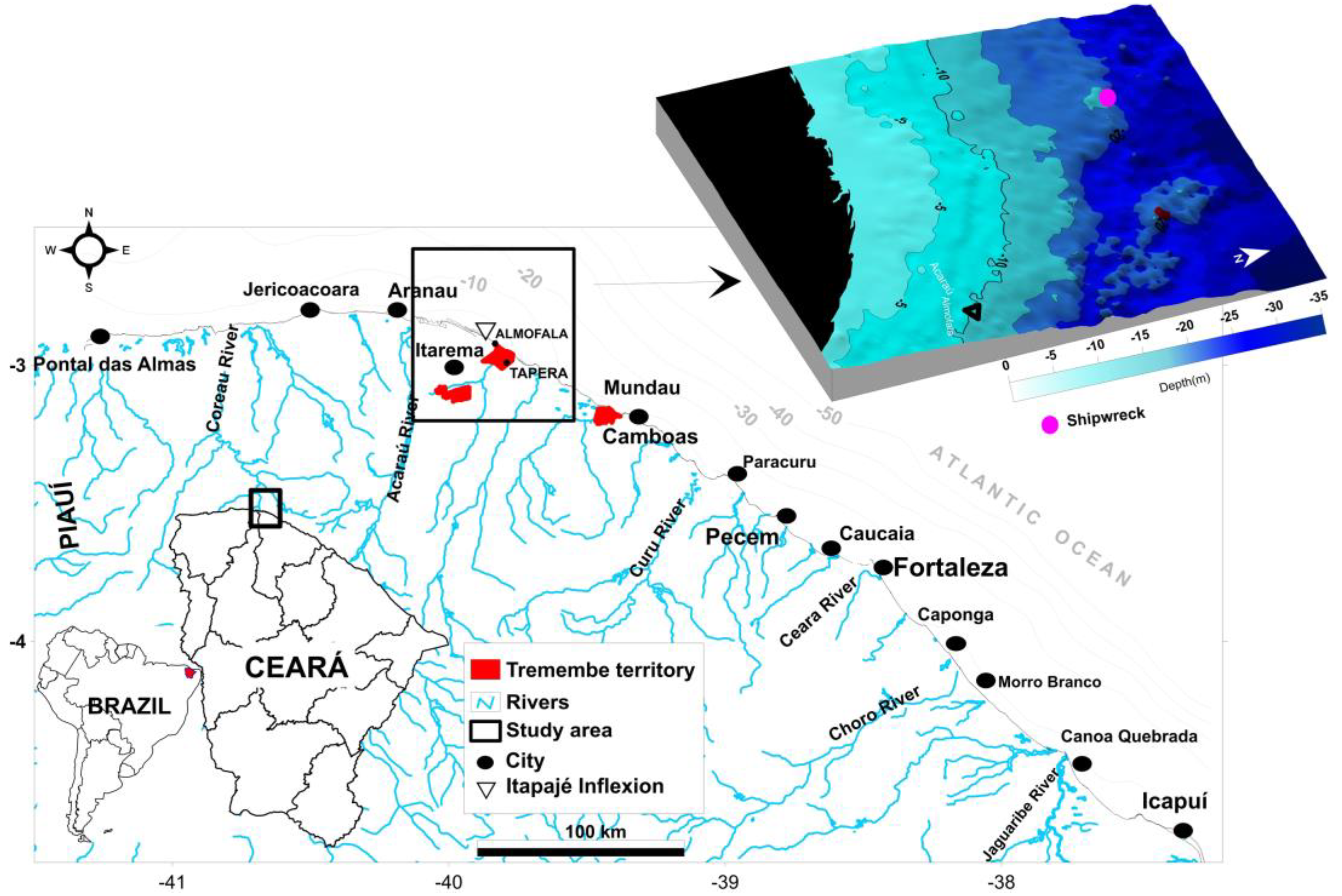
2.1. Study Area

The study was carried out in the fisherman’s community of Tremembé, located in Itarema municipality of the State of Ceará, Brazil (Figure 1). In 2016, the Tremembé indigenous ethnic group numbered 3888 people distributed between Itarema, Itapipoca, and Acaraú [34]. This community’s livelihoods depend on crab collection in mangroves, agriculture, and sea fishing. These activities are carried out individually or in groups [24]. Artisanal fisheries occur predominantly on the inner shelf, using sailing boats, and constitute an essential local subsistence activity [20,22]. The Ceará’s continental shelf comprises three bathymetric zones: inner shelf < 20 m, middle shelf 20–40 m, outer shelf > 40 m to the shelf break, ~60–70 m, presenting mixed sedimentation features [35]. The coastal zone is characterized by dunes, estuaries with mangroves, sand spits, and flat beaches [36,37]. The tides reach amplitudes of 3.3 m favoring the use of intertidal zones for the construction of “fishing corrals” and other harvesting activities by the local community [36].
The climate in this area is tropical hot semiarid, with temperatures ranging from 25 °C to 32 °C. Annual rainfall can reach 1100 mm and is concentrated between February and April [38]. The rivers that flow into the ocean are intermittent, with a reduced influx of sediments to the continental shelf due to the influence of the semiarid climate [39,40]. The main wind regimes are fundamental for artisanal fishing, which occurs predominantly with sailboats on the inner shelf, and constitutes an essential local subsistence activity [20,22]. The strong and constant wind (9 m.s−1 ± 2.5) generates an international tourism activity based on kite surfing in estuaries and the sea [41] and sets suitable conditions for the installation of onshore and offshore wind farms [40,41,42,43].

2.2. Data Collection and Analysis

Focus groups were used to promote an open discussion of local users’ knowledge [9,44] about seascapes and substrates and their importance for local fisheries. We invited all men and women identified with indigenous fishermen who were part of the Tremembé colonies of the Almofala and Tapera (n = 80) Figure 1. This was because of the secular relationship with the seascape and fishing activities [24,29]. We held two (2) meetings in October and November 2021. The total numbers of fishermen who attended each meeting were 30 (38%). Of those present in the participatory mapping at Almofala, 3 (33%) were women and 10 (77%) men. In Tapera, 16 men (94%) and 1 (6%) woman participated. In Almofala and Tapera, 90% and 74% of fishermen had more than 10 years of experience and knowledge about inner shelf artisanal fishing, respectively.
The strong connection between the person and the seascape can be reflected in sensitive relationships with the place [8]. Data on daily experiences with seascapes and sea fishing were collected in four steps.
The first step was to edit a basic map with the following information: (a) Three geomorphological macro-compartment limits of the continental shelf [35,45] and their respective sedimentary facies [37] (Figure 2a); (b) Bathymetric map compiled from nautical charts from the Brazilian Navy and Database’s Geodiversity Beach-Continental shelf Project (GBCSP-project), Figure 2b; (c) Distance scale in fathoms and meters; (d) Spatial representation of shipwrecks, coastline, mangroves, drainage, and villages (Figure 2). This map made possible the spatial positioning of the respondents, who use the landmarks on land and the distance from the coast as elements for navigation.
Sediment samples kits and image slides from video transects were prepared in a second step. They contained samples of the seven main types of bottom sediments collected in the area by the GBCSP project and substrates’ images obtained by ROV, side scan sonar, scuba diving, and remote sensors [28,29,35,37,45,46].
During the meetings (third step), fishermen had the opportunity to see, handle, and name the sediments based on their traditional knowledge. They pointed on the map where the different shown sediments should be present. The same method was applied after exposing the images and videos to identify the geomorphological features. There was always a dialogue between them on the choice of terminology and/or spatial distribution on the map, which was unanimously agreed upon in most cases. Only in some very specific cases, decisions were made by the majority of those involved. In these moments, the speech of more experienced or older fishermen had weight in the final decision of which terminology to use. They expressed their ideas in oral reports, which contributed to the construction of the Traditional Terms table. All these observations were qualitatively recorded in the field notes in chronological order [47]. These notes allowed us to better interpret the responses obtained concerning perceptions of seascapes through the data collection techniques described above.
Participant observation [9,48] was carried out during community visits to improve our understanding of the community’s social organization and way of life. We also engaged in informal talks and local celebrations with residents of villages. In the case of participatory mapping, they identified/pointed, and correlated with their reports, which contributed to the construction of the maps. Spatial information on seascapes was complemented with data on the presence of economically important species. The application of Participatory Mapping in this work prioritized fishermen as actors in the investigative and participatory process, resulting in the representation and construction of territorial, environmental, popular, symbolic, and cultural knowledge [49].
In the fourth step, we used the result of the seascape ethnomap to complement scientific literature data, elaborating a seascape map. To do that, bottom sediment data from the area available in the scientific literature and produced at different scales were reanalyzed [35,40,46,50,51,52,53,54,55,56]. This was the base used to draw a map of sedimentary facies, prepared using Larsonneur’s classification [57], modified by Dias et al. [58]. In such a map, we consider the CaCO3 content (%) as an indicator of biogenic activity. After that, the sedimentary maps obtained from the reanalysis and those produced by the fishermen were grouped and improved with scale corrections and caption adjustments. The correlation between organisms caught, and the different seabed types found, was corroborated by the inventory of the ichthyofauna of the artisanal fleet captured off the coast of Ceará [59] and the Marine Fish Report—REVIZEE Program [60].
A map of benthic structures was prepared to complement and validate the seascape geomorphology data available in the scientific literature and the data produced by participatory mapping [61,62,63] with the extension (BTM), for ArcGIS™ 10.5. A bathymetric grid was used, following the methodology and classification criteria proposed for the Pernambuco Continental Shelf, in the Northeast of Brazil [64,65].
After analyzing the conversations, interpreting the maps, and applying descriptive statistics, it was possible to correlate the products of participatory mapping with the data available in the literature, resulting in the seascape map.

3. Results

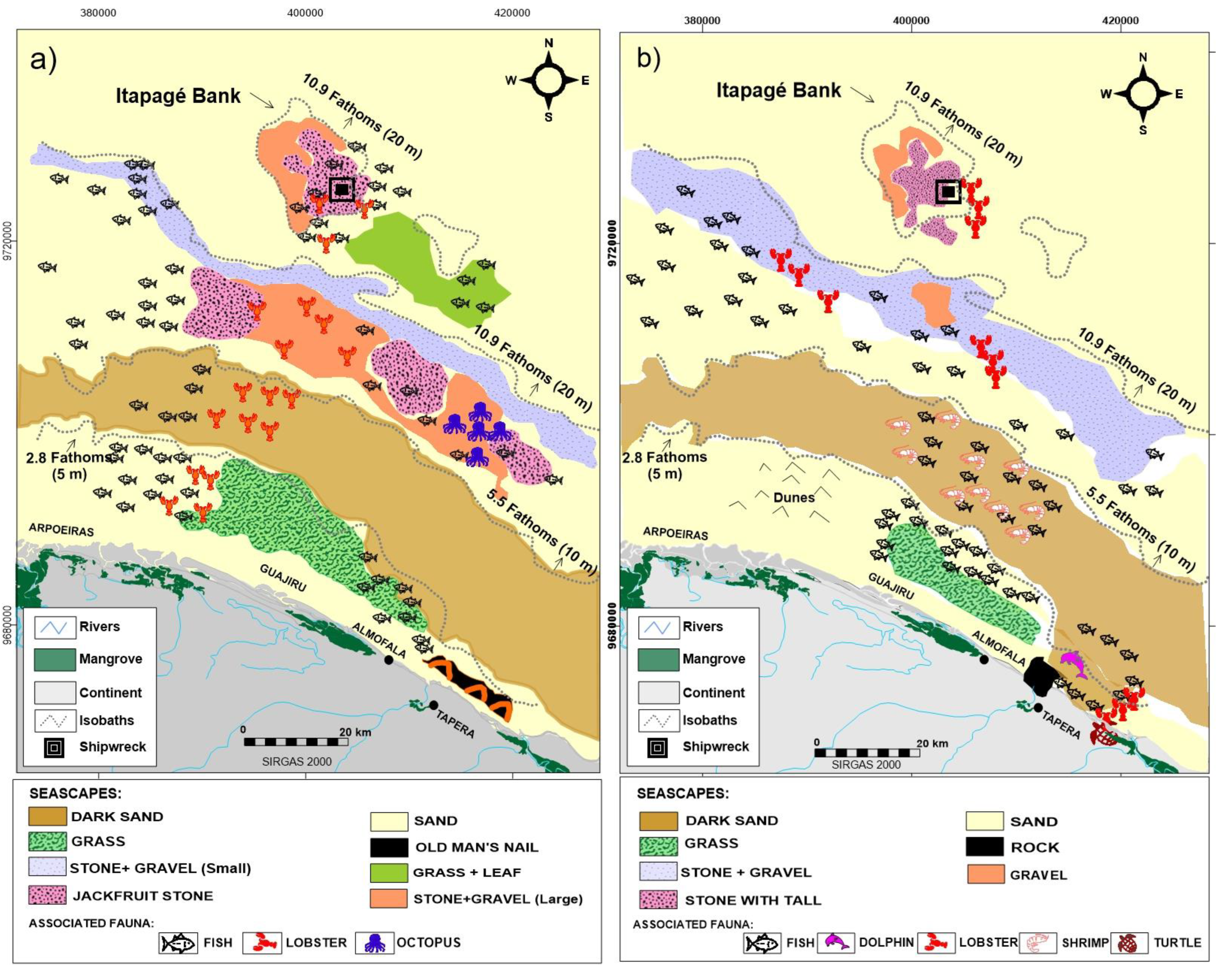
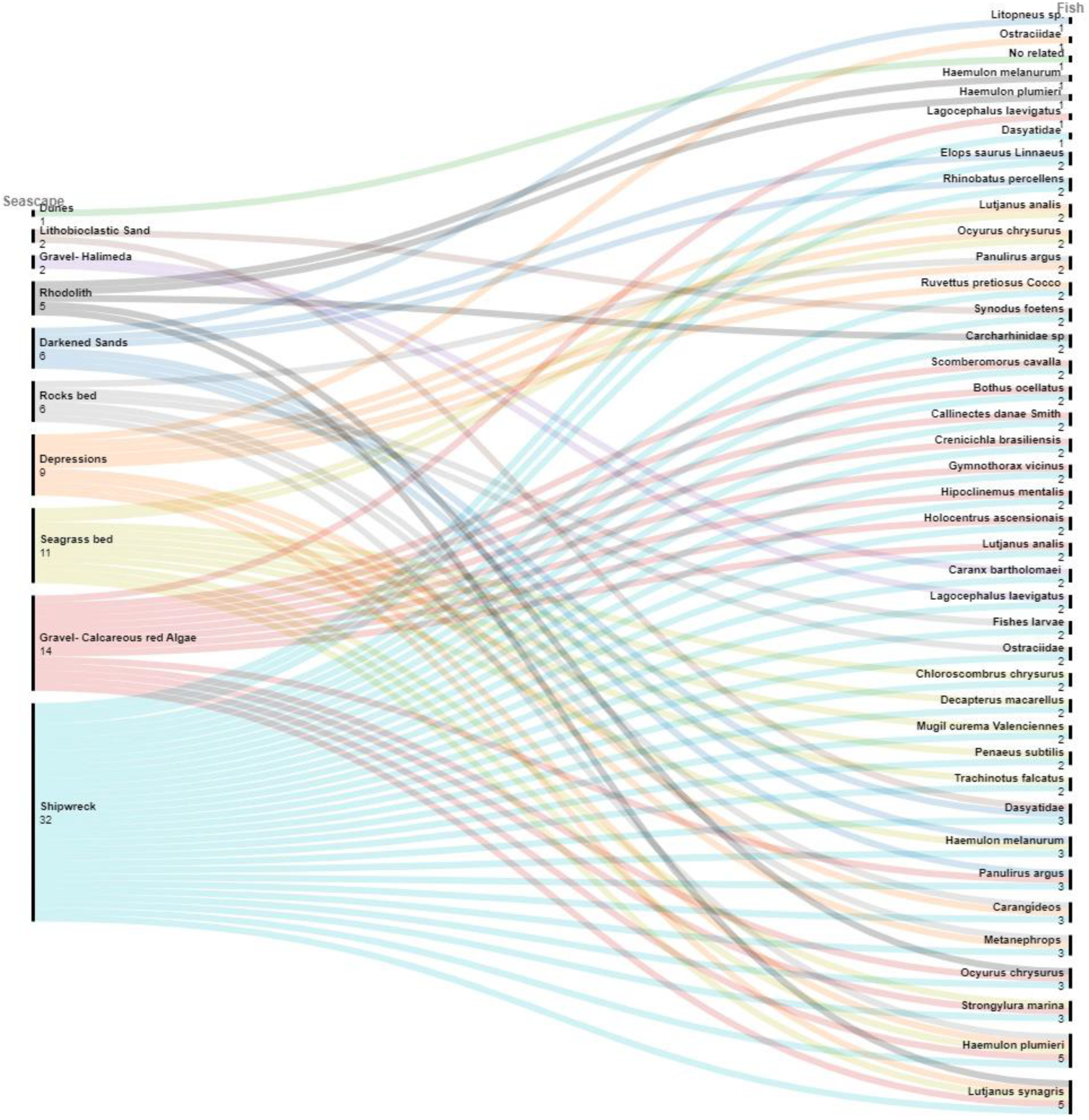
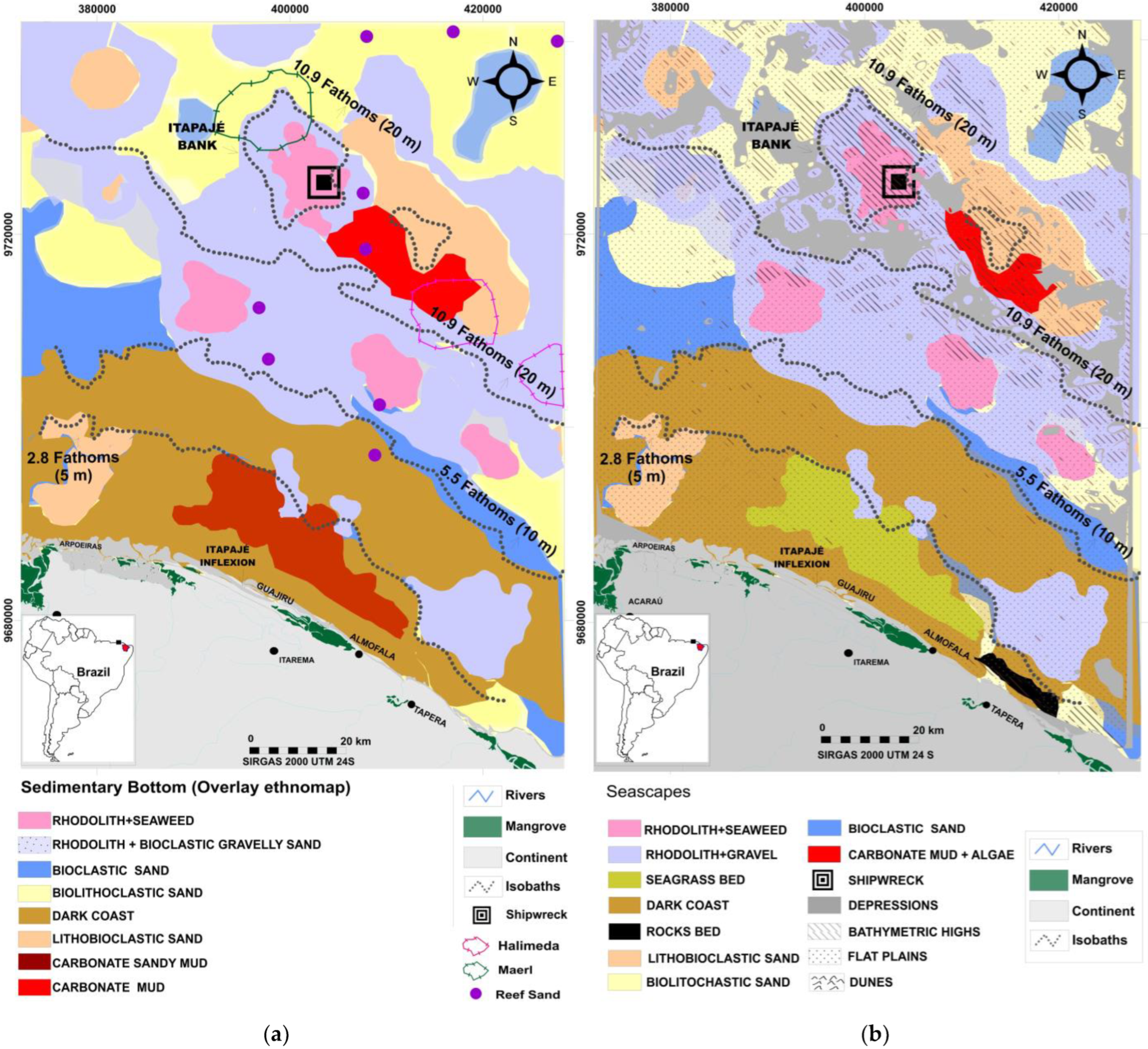
3.1. Seascape Based on the Experience of Tremembé Fishermen

Geomorphologic changes of the bottom from the Itapajé Inflection in both fishing communities were described. Almofala Beach is the land reference used to distinguish shallow (western) areas from deeper (eastern) areas within the inner continental shelf. Shipwrecks, banks, channels, holes, “Cabeço”/knoll, deer antler, grass, and mud are terms used by fishers as references for fishing spots. The depth measurement unit used by fishermen is the fathom (1 fth = 1.8 m). In the past, this depth measurement was made with the use of “cords and plummets”, but today, a simple echo sounder for navigation in some boats is used. Soap attached to a plumb cord to see the type of sediment is still used in small rafts.
Based on the description of the sedimentology and geomorphology of the fisheries areas, nine seascapes were identified: Six (6) seascapes directly associated with the bottom sediment characteristics, two (2) associated with geomorphological features, and one (1) with the artificial substrate (Table 1 and Figure 3).
Grain size, shape, texture, and colors were the main references used to distinguish the types of bottoms (e.g., large and small gravels, stone with tail, and dark sand), among others (Table 1). In Almofala, fruit and plant names and terrestrial animal characteristics were mostly used to define the types of bottoms, associated with rigid subtracts and rhodolith (e.g., Jackfruit, Deer antler, Chicken foot). Bank terms were used to highlight features with higher bathymetric elevations concerning the surroundings, such as submerged sand dunes and rock outcrops.
“Cabeço” is a term used to designate rock outcrops. “Deer antler” was assigned to a distinct type of rock outcrop, probably with erosive features and structures colonized by coral species that resemble the deer antler ornamental plants (Platycerium bifurcatum) or the animal’s characteristic. Channels and holes were used for depressions between rock outcrops or dunes. The term “fish estuary” was used at various times to define the “holes” that presented themselves as a favorable environment for fishing.
Grass mapping (seagrasses) was coincident in the two communities and is located between the lowest tide level and the 5 m depth. This term defined areas with seagrass meadows, represented mainly by the Halodule wrightii, in the flattest sector of the region, between the beaches of Guajirú and Almofala. The term “fish estuary” was also used for the seagrass bed in the Almofala community. There are estuarine lagoons colonized by mangroves in this littoral, with artisanal fishing. Seagrass seascape borders sandy bottoms rich in bioclastics and rhodoliths, in addition to the presence of some rocky substrates, which they call “stone” (Figure 3). The Almofala fishermen indicated, in depths greater than 20 m, an area called by them “grass with mud sand” near the bank of Itapajé. The terminology “grass” is used simultaneously for areas with phanerogams and algae; the distinction between them is made from the description of the type of bottom. Areas with living Halimeda sp. are called areas with Stone and Big Gravel, Stones’ sludge, or Leaves (Figure 3a,b).
At the top of the Itapajé bank, the substrates defined as “stone with tail” and “jackfruit” were predominated. These names were attributed to rhodoliths with erect attached algae. The name of rhodoliths without the presence of algae is a “stone” for the fishermen. Seascapes with substrates called gravels and stones with “Chicken foot” and coral are associated with areas with the occurrence of red algae and/or maerl. The sector with the occurrence of rhodoliths in the Itapajé bank was coincident among the fishermen, which demonstrates that they are fishing territories used by both communities. Coral terminology is also used by the communities of Itarema for these deposits. Areas with red algae are identified by them as good for fishing.
To the west of the Itapajé bank are stones with small gravels and “chicken feet”, referring to bioclastic sands with fragments of red algae. The fishermen of Almofala indicated three well-defined areas with the occurrence of the types of rock bottoms with “tail” and “jackfruit” (rhodoliths), within the great domain of gravelly bioclastics with fragments of red algae between the isobaths of 10 and 20 m. There is a clear distinction between the areas defined by them as darkened sand and the whitish sands or “bubble sand”, which are the lighter-colored biolithoclastic and lithobioclastic sands located on the beach strip and in areas of the continental shelf. The fishermen highlighted the type of bottom called “dark sand”, located between 5 and 10 m, as a fertile area for fishing.

3.2. Seascapes and Fishing

Similar perceptions about the relationship between marine seascapes and organisms caught were related. Seagrass beds are an important area for fishing. Eleven species were captured throughout the year, besides the occurrence of fish larvae. The decrease in the number of species was due to the fishing device, and the detachment of the grass from the sea floor. In areas with rhodoliths (called Jackfruit or Stone with Tail), five species of fish were described. Artisanal fishing takes place in the first area (<20 m). Morphological discontinuity on outcrops known as Head or Deerhorn eases different types of organisms’ presence. Six species (6) are caught there, besides the occurrence of fish larvae. In depression areas called holes and channels, nine (9) species were mentioned, including the lobster (Panulirus argos). The shipwreck was related as the best place for fishing because it has several shelters for fish and a variety of carbonate bottoms. Practically all species (32) reported by fishermen, in their different life stages, can be found in this place. In the areas of submerged sandy dunes, no species fished in both communities were mentioned. About unconsolidated bottoms, the abundance of fish varies according to the characteristics of the carbonate sediments. Thus, places with the presence of rhodolith with red algae and/or red algae gravel were associated with good places for fishing, with fourteen (14) species of fish and crustaceans captured. However, when only whitish bioclastic (stone and gravel) occurs, the environment is poorer for fish, but crustaceans and other associated organisms occur.
In areas with Halimeda and Halimeda’s gravels (Leaf and Stones’ sludge), there is fishing of five (5) species, as well as in areas with Dark Sand. The fishermen emphasized that the types of the bottom are interconnected since the organisms are mobilized; however, some seascapes, due to the presence or not of a type of bottom, may represent the greatest abundance of a given species (Figure 4). The species Haemulon plumieri occurred in six (6) seascapes, followed by Panulirus argus, Ocyurus chrysurus, and Lutjanus synagris present in five (5) seascapes in the studied area. In the sequence, the species Dasyatidae sp, Lutjanus analis, and Haemulon melanurum occurred in four (4) seascapes. Except for the dunes, the other species captured occurred, at least, in two and three seascapes.

4. Discussion

The shallow shelf has two morphological patterns. The first is in the NW-SE direction, with greater slopes, and the second is in the E-W direction [35,37]. The fishermen use Praia de Almofala as a reference point for this geomorphological compartmentation. The region between the coastline and the 20 m isobath is predominantly characterized by a low-slope relief, with sparse occurrences of flat ridge tops associated with rocky bottoms (Figure 5a), such as siliciclastic sandstones and/or conglomerates, submerged aeolianite, or beach rock [36]. In this sector there are seagrass beds related to carbonated muddy sands and colonized by Halodule wrightii, between the estuary-lagoon of Guajirú and the isobath of 5 m, demonstrating a good correlation with the data obtained in the participatory mapping. The dominance of organisms in the early stages of development (fish eggs and larvae) in seagrass from Itarema was observed, demonstrating a preference for more protected and less turbulent marine seascapes for nursery and hatchlings [29]. In this same sector, there are “dark sands”, mapped by fishermen as a good place for fishing. In this zone, there are darkened biolithoclastic sands associated with calcareous algae and foraminifera [35]. Several morphological patterns such as ripples and small dunes occur in this sector [37] as mapped by fishermen from the Tapera village.
The rock outcrops called “stones” and “old man’s nail” in Almofala coincide with the flat ridge top found in the benthic structure map (Figure 5a). The sedimentation of the beach is characterized as mixed, considering the balanced percentages between siliciclastic and bioclastic sands [39], which were attributed by the fishermen to the classification of “sand”.
Lithobioclastic sands appear as patches at the mouth of the Acaraú River in shallow areas parallel to the 20 m isobath east of the upper Itapajé (Figure 5b). Rhodolith beds have also been mapped in these shallow areas [28], associated with muddy bioclastic and biolithobioclastic sands. It was observed that in the same perpendicular alignment of the Guajirú estuary and the East of Itapajé bank, in the isobath of 20 m, carbonate mud spots appear, which were associated with the occurrence of foliage algae identified by the fishermen (Figure 5b). Between depths of 10 and 20 m, the relief is more rugged with the presence of dunes, rocky outcrops, escarpments, terraces, and depressions between these features (Figure 5a).
The depressions called “holes” and “channels” are located over 20 m in depth between rock outcrops. The depressions are bordered by “Cabeços” and Deer Antlers. In the participatory mapping, these features were not represented, despite the constant mention of stone bottoms by fishermen and their importance for the capture of a greater number of species. On Caponga beach, on the east coast of Ceará, the term “cabeço” was used to describe the “stone with fish on it” by fishermen, associated with massive corals [32]. The use of the term “deer antlers” can be related to pinnacles in depressions, probably (Figure 5a). Prominence was given to the shipwreck in this area, considered by fishermen to be a strategic fishing area. The mapped structures are associated with marine reefs, which are rich and productive environments [66] and fundamental for the food security of traditional populations.
In this sector, there is also a more abundant form of “tail stones” and “jackfruit stones”, mainly associated with rhodolith and bioclastic gravel sands with rhodolith and lithobioclastic sands of varying sizes (Figure 6a). There are records of live red algae and maerl and the occurrence of Halimeda incrassata [50]. The interpolation of the results of the participatory mapping with the map produced from the reanalysis of data revealed that the areas with seagrass meadow, rhodoliths, bioclastic gravels, and the Dark Coast may occupy a much larger area than recorded in the geological and geomorphological surveys published so far. It should be noted that the surveys with detail in the region were carried out by the GBCSP-PRONEX Project [46] in the inner shelf (<10 m), in the years 2013 and 2018, the other studies contemplated a regional scale. The take-home message is that it is possible (and desirable) to make the local people’s perceptions of the habitat distribution match with the scientific mapping, being a necessary calibration.
Comparing the preferred habitat of the species listed in the participatory mapping, on the coast of the State of Ceará, we found that 41% are associated with rock bottoms, 25% with gravel and rock bottoms, 18% with mixed environments of sand, mud, and gravel, and 9% of the organisms were present in the water column (Figure S1) [59,60]. The species are predominantly benthic and validate the correlation made by fishermen between the types of bottoms and the organisms they fish there.
The diversity of substrates starting from the 10 m isobath is reflected in the increase in fish species, mainly associated with gravel bottoms with the presence of carbonate algae (Figure 6b). However, it was observed that species such as the lobster Panulirus argus occur from areas close to the coast to seascapes located at greater depths associated with carbonate bottoms [52,67]. From the 20 m isobaths, there is a high diversity of geomorphological features, with a predominance of bathymetric highs with flat bottoms and/or capped by rhodoliths, carbonate gravels, halimedas, and maerl [37,55], favoring a greater diversity of species, as observed in the description of the species caught in the wreck, which is located in an area with characteristic reef environments.
This result agrees with the recent mapping of an extensive reef located between 20 and 50 m deep, along the entire Brazilian semiarid coast [66]. The participatory mapping made it possible to complement important geological and geomorphological information about the substrates and connectedness of some species, an important tool for the food security of these communities (Figure 6b). These substrates are essential to understanding fish biomass. Many species are associated with these complex habitats, and their change may affect the available protein for local people [68]. The analogy with the coastal system refers to productivity and the juvenile life cycle of some species fished, probably, being that such productivity is linked to the presence of algae or coral assemblages. Identifying these habitats as quickly as possible will be essential for a better management of the coastal areas.
In general, there is a large gap of knowledge to be generated in this region and in other regions of the world that deserves attention due to the increase in demand for hydrocarbon exploration, offshore wind power generation, carbonate exploration, siliciclastic mining for beach recovery, and other activities associated with the Economy of the Sea [36]. Fulfilling this gap of knowledge may be considered a priority in national and international coastal and offshore governance. Natural ecosystems and landscapes that provide benefits to human society are of great ecological, socio-cultural, and economic value [69,70,71] to develop a rational baseline to protect the natural capital of a region. For this reason, it will be essential to make a proper bottom-up approach with the local people, inviting them to make active ethnocartography. The use of this habitat mapping, qualitative but explicit in the habitat distribution, is perhaps the key to boosting conservation and management plans in many areas of the world.

5. Conclusions

The link between certain marine habitats and species’ presence and abundance is not new [72]. Certain species such as cephalopods, benthic fishes, or crustaceans may be found where the seagrass or seaweed presence is abundant [73,74]. Now there is a more accurate vision of the importance of complex habitats (marine forests, line seagrasses, seaweeds, marine animal forests) [75,76] as ecosystem services providers. The habitats in which these three-dimensional living structures (forests) are present are those in which the local people also agree there is more capacity to fish. The novelty of this work, validated by the standardized scientific protocol used in the area, is the mapping approach made with the help of local know-how to localize not only the habitats but the associated species, providing tools for administrations to manage resources and conservation plans. As a particular example, the data produced by this work support the creation of a Marine Protected Area, to guarantee the food safety of Tremembé fishermen in Almofala and Tapera, being possible thanks to a bottom-up approach.
In synthesis, the application of these tools may serve the following purposes: (1) to make extensive mappings thanks to the know-how of the local people, especially in areas where the scientific methods are not available or are difficult to apply (also for budget constraints), (2) to validate relationships between species presence and a determinate habitat, to make conservation and management plans; vulnerable species or habitats may be more easily protected, and the link between complex systems and vagile fauna may be reinforced [77], and (3) to make possible the active participation of local populations in conservation and management processes [9], allowing the creation of a truly bottom-up process [78,79]. This may be a win–win situation in which the democratization of the decisions is at stake, and the link between local people and the administration may be boosted by a quite simple but effective protocol.

Supplementary Materials

The following supporting information can be downloaded at: https://www.mdpi.com/article/10.3390/w15040798/s1, Figure S1: Bottom types and associated species in seascapes used for fishing. Source: Seascape by ethnogeomorphology mapping, Bottom types: St = Stone, G = Gravel, S = Sand, M = Mud, N = Nekton organisms [56,57], c) fish species (Participatory Mapping).

Author Contributions

Conceptualization, L.P., A.R.X.N., F.A.A.B.F., L.B. and S.R.; Data curation, L.P., A.R.X.N., F.A.A.B.F., C.R.S.P. and L.d.S.P.; Formal analysis, L.P.; Funding acquisition, L.P., A.R.X.N., J.M., A.G. and S.R.; Methodology, L.P., A.R.X.N., F.A.A.B.F., C.R.S.P., L.d.S.P., P.P., R.L.F., R.B.d.S. and J.M.; Software, L.P. and L.d.S.P.; Supervision, L.P. and S.R.; Validation, L.P.; Writing—original draft, L.P.; Writing—review & editing, L.P., A.R.X.N., F.A.A.B.F., A.G., L.B. and S.R. All authors have read and agreed to the published version of the manuscript.

Funding

Fundação Cearense de Apoio ao Desenvolvimento Científico (GBCSP-PRONEX PR2-01010-00008.01.00/15T, DSATECEHV-PS1-0186-00295.01.00/21). Conselho Nacional de Desenvolvimento Científico e Tecnológico-CNPq. (Research Productivity Fellowship 316941/2021-2,308830/2021-0, 306462/2018-4 and LEMAE/FINEP 380986/2022-1). Coordenação de Aperfeiçoamento de Pessoal de Nível Superior (CAPES- Financial Code:001).

Data Availability Statement

Not applicable.

Acknowledgments

We have immense gratitude for the people of the Tremembé Aldea (Itarema). The study followed the international guidelines and the Ethical committee of the Universidade Estadual do Ceará (CAAE de n° 97069218.0.0000.5534-Coastal Zone of Itapipoca, Itarema, and Acaraú (Ceará, Brazil): Case study from the GTP system and Environmental Perception of Tremembé Indigenous Aldeas project). We thank the Conselho Nacional de Desenvolvimento Científico e Tecnológico (Research Productivity Fellowship: 316941/2021-2,308830/2021-0, 306462/2018-4), Fellowship LEMAE/FINEP/CNPq No 380986/2022-1, CAPES-PRINT (Finance code 001), Fundação Cearense de Apoio ao Desenvolvimento Científico e Tecnologico for their financial support (Chief Scientist Program, “Desafios Sociais e Ambientais da Transição Energética no Ceará” project -PS1-0186-00295.01.00/21 and GBCSP-PRONEX “Geodiversidades, interações e impactos socioambientais no sistema praia-plataforma da costa Oeste do Ceará” Project-PR2-01010-00008.01.00/15), and “Etnogeomorfologia na planície litorânea e plataforma continental: O caso da Costa Negra”(PROEX/UECE) project. This publication is based upon work from COST ACTION Marine Animal Forests of the World (MAF-WORLD), CA20102, supported by COST (European Cooperation in Science and Technology).

Conflicts of Interest

The authors declare no conflict of interest.

References

  1. Baker, E.K.; Harris, P.T. 2—Habitat Mapping and Marine Management. In Seafloor Geomorphology as Benthic Habitat; Harris, P.T., Baker, E.K., Eds.; Elsevier: London, UK, 2012; pp. 23–38. ISBN 978-0-12-385140-6. [Google Scholar]
  2. Rossi, P.; Ponti, M.; Righi, S.; Castagnetti, C.; Simonini, R.; Mancini, F.; Agrafiotis, P.; Bassani, L.; Bruno, F.; Cerrano, C.; et al. Needs and Gaps in Optical Underwater Technologies and Methods for the Investigation of Marine Animal Forest 3D-Structural Complexity. Front. Mar. Sci. 2021, 8, 591292. [Google Scholar] [CrossRef]
  3. Galparsoro, I.; Borja, A.; Uyarra, M.C. Mapping Ecosystem Services Provided by Benthic Habitats in the European North Atlantic Ocean. Front. Mar. Sci. 2014, 1, 23. [Google Scholar] [CrossRef] [Green Version]
  4. Sardá, R.; Rossi, S.; Martí, X.; Gili, J.M. Marine Benthic Cartography of the Cap de Creus (NE Catalan Coast, Mediterranean Sea). Sci. Mar. 2012, 76, 159–171. [Google Scholar] [CrossRef] [Green Version]
  5. Ribeiro, S.C.; Marçal, M.D.S.; de Corrêa, A.C.B. Etnogeomorfologia sertaneja—O conhecimento tradicional do produtor rural nordestino sobre o relevo e seus processos na sub-bacia do Rio Salgado/CE. GEOgraphia 2015, 17, 205–224. [Google Scholar] [CrossRef] [Green Version]
  6. Ribeiro, S. Etnogeomorfologia sertaneja: Estudo dos conhecimentos dos produtores rurais do sitio canabravinha, distrito de palestina do cariri, mauriti, ce, acerca dos processos morfodinâmicos. Rev. Geosaberes 2015, 16, 103–112. [Google Scholar]
  7. Toledo, V.M.M.; Barrera-Bassols, N. A etnoecologia: Uma ciência pós-normal que estuda as sabedorias tradicionais. Desenvolv. E Meio Ambiente 2009, 20, 31–45. [Google Scholar] [CrossRef]
  8. Wilcock, D.; Brierley, G.; Howitt, R. Ethnogeomorphology. Prog. Phys. Geogr. Earth Environ. 2013, 37, 573–600. [Google Scholar] [CrossRef]
  9. Queiroz, L.D.S.; Rossi, S.; Calvet-Mir, L.; Ruiz-Mallén, I.; García-Betorz, S.; Salvà-Prat, J.; de Meireles, A.J.A. Neglected Ecosystem Services: Highlighting the Socio-Cultural Perception of Mangroves in Decision-Making Processes. Ecosyst. Serv. 2017, 26, 137–145. [Google Scholar] [CrossRef]
  10. Torri, D. The Coral Tree at the End of the World: Introductory Notes to Coralline Mythology and Folklore from the Indian and Pacific Oceans. In Perspectives on the Marine Animal Forests of the World; Rossi, S., Bramanti, L., Eds.; Springer International Publishing: Cham, Switzerland, 2020; pp. 1–16. ISBN 978-3-030-57054-5. [Google Scholar]
  11. Jones, G.B. The Reef Sulphur Cycle: Influence on Climate and Ecosystem Services. In Ethnobiology of Corals and Coral Reefs; Narchi, N., Price, L.L., Eds.; Springer International Publishing: Cham, Switzerland, 2015; pp. 27–57. ISBN 978-3-319-23763-3. [Google Scholar]
  12. Price, L.L.; Narchi, N.E. Ethnobiology of Corallium Rubrum: Protection, Healing, Medicine, and Magic. In Ethnobiology of Corals and Coral Reefs; Narchi, N., Price, L.L., Eds.; Springer International Publishing: Cham, Switzerland, 2015; pp. 73–86. ISBN 978-3-319-23763-3. [Google Scholar]
  13. Tsounis, G.; Rossi, S.; Grigg, R.; Santangelo, G.; Bramanti, L.; Gili, J.-M. The Exploitation and Conservation of Precious Corals. In Oceanography and Marine Biology; CRC Press: Boca Raton, FL, USA, 2010; pp. 161–211. [Google Scholar]
  14. Olvera, M.M.C.; Sánchez, M.M. La Historiografía Ambiental Sudcaliforniana y La Sustentabilidad Local. Hist. Ambient. Latinoam. Caribeña HALAC Rev. Solcha 2018, 8, 14. [Google Scholar] [CrossRef]
  15. Sánchez-Rodríguez, A.; Aburto-Oropeza, O.; Erisman, B.; Jiménez-Esquivel, V.M.; Hinojosa-Arango, G. Rocky Reefs: Preserving Biodiversity for the Benefit of the Communities in the Aquarium of the World. In Ethnobiology of Corals and Coral Reefs; Narchi, N., Price, L.L., Eds.; Springer International Publishing: Cham, Switzerland, 2015; pp. 177–208. ISBN 978-3-319-23763-3. [Google Scholar]
  16. Jiménez, C.; Orejas, C. The Builders of the Oceans—Part II: Corals from the Past to the Present (The Stone from the Sea). In Marine Animal Forests: The Ecology of Benthic Biodiversity Hotspots; Rossi, S., Bramanti, L., Gori, A., Orejas, C., Eds.; Springer International Publishing: Cham, Switzerland, 2017; pp. 657–697. ISBN 978-3-319-21012-4. [Google Scholar]
  17. DeGraff, A.K. Participatory Mapping: Evaluating Practice in Caribbean Small Island Developing States. Ph.D. Thesis, University of the West Indies, Kingston, Jamaica, 2015. [Google Scholar]
  18. Alves, L.D.; Madeira Di Beneditto, A.P.; Zappes, C.A. Ethnooceanography of Tides in the Artisanal Fishery in Southeastern Brazil: Use of Traditional Knowledge on the Elaboration of the Strategies for Artisanal Fishery. Appl. Geogr. 2019, 110, 102044. [Google Scholar] [CrossRef]
  19. Alves, L.D.; Di Beneditto, A.P.M.; Ghisolfi, R.D.; Quaresma, V.D.S.; Zappes, C.A. Comparisons between Ethnooceanographic Predictions by Fishermen and Official Weather Forecast in Brazil. Ocean Coast. Manag. 2020, 198, 105347. [Google Scholar] [CrossRef]
  20. Braga, M.S.D.C. Embarcações a vela do litoral do Estado do Ceará Construção, Construtores, Navegação e Aspectos Pesqueiros. Ph.D. Thesis, Universidade Federal do Ceará, Fortaleza, Brazil, 2013. [Google Scholar]
  21. Muehe, D.; Garcez, D.S. A plataforma continental brasileira e sua relação com a zona costeira e a pesca (the Brazilian continental shelf and its relation with the coastal zone and fishing). Mercator 2005, 4, 69–88. [Google Scholar]
  22. Xavier, T.; Gorayeb, A.; Brannstrom, C. Participatory cartography as a means to facilitate democratic governance of offshore wind power in Brazil. In Energy Democracies for Sustainable Futures; Nadesan, M., Pasqualetti, M., Keahey, J., Eds.; Elsevier: London, UK, 2022; Volume 1, pp. 185–194. ISBN 978-0-12-822797-8. [Google Scholar]
  23. De Arruda, J.C.; da Silva, C.J.; Sander, N.L.; Pulido, M.T. Conhecimento ecológico tradicional da ictiofauna pelos quilombolas no Alto Guaporé, Mato Grosso, Amazônia meridional, Brasil. Bol. Mus. Para. Emílio Goeldi Ciênc. Humanas 2018, 13, 315–329. [Google Scholar] [CrossRef]
  24. Bezerra-Filho, F.D.A.; PInheiro, L.S.; Pessoa, P.R.S. Paisagem, Território e Identidade: A Percepção Ambiental dos Indígenas Tremembé na Zona Costeira do Nordeste Setentrional Brasileiro. Available online: https://revistas.ufg.br/bgg/edicao (accessed on 12 December 2022).
  25. Leff, E. Ecologia, Capital e Cultura: A Territorialização da Racionalidade Ambiental, 1st ed.; Ediitora Vozes: Petrópolis, Brazil, 2009; Volume 1, ISBN 85-326-3918-6. [Google Scholar]
  26. Villas Boas, G.H.; Marçal, M.; Brierley, G. An Ethnogeomorphic Case Study of Conservation Practices in Southeast Brazil. Hum. Ecol. 2022, 50, 651–664. [Google Scholar] [CrossRef]
  27. Rossi, S. Oceans in Decline|SpringerLink. Available online: https://link.springer.com/book/10.1007/978-3-030-02514-4 (accessed on 12 December 2022).
  28. de Macêdo Carneiro, P.B.; de Lima, J.P.; Bandeira, Ê.V.P.; Neto, A.R.X.; Barreira, C.D.A.R.; de Souza Tâmega, F.T., Matthews-Cascon; Matthews-Cascon, H.; Franklin, W., Jr.; de Morais, J.O. Structure, Growth and CaCO3 Production in a Shallow Rhodolith Bed from a Highly Energetic Siliciclastic-Carbonate Coast in the Equatorial SW Atlantic Ocean. Mar. Environ. Res. 2021, 166, 105280. [Google Scholar] [CrossRef]
  29. Costa, A.C.P.; Garcia, T.M.; Paiva, B.P.; Ximenes Neto, A.R.; de Oliveira Soares, M. Seagrass and Rhodolith Beds Are Important Seascapes for the Development of Fish Eggs and Larvae in Tropical Coastal Areas. Mar. Environ. Res. 2020, 161, 105064. [Google Scholar] [CrossRef]
  30. Gorayeb, A.; Mesquita, R.D.P.; Aquino, T.S.D.; da Silva, R.B.; Silva, G.D.C. Análise multicritério de parques eólicos onshore e offshore no Ceará: Em foco as comunidades tradicionais litorâneas. Rev. Mutirõ Folhetim Geogr. Agrár. Sul 2022, 3, 32–59. [Google Scholar] [CrossRef]
  31. Andrade, A.B.; Soares, M. Offshore Marine Protected Areas: Divergent Perceptions of Divers and Artisanal Fishers. Mar. Policy 2017, 76, 107–113. [Google Scholar] [CrossRef]
  32. Borgonha, M.; Bertoncini, A.; Monteiro-Neto, C.; Sampaio, J. Entre céu e água: Elementos de navegação marítima oceânica e costeira dos jangadeiros da Caponga, litoral do Ceará. In Avanços em Oceanografia Humana; Moura, G., Ed.; Paco Editorial: Jundiaí, Brazil, 2017; Volume 1, pp. 121–158. ISBN 978-85-462-0806-7. [Google Scholar]
  33. Pantalena, A.F.; Soares, M.D.O.; Rodrigues, L.C. Divers Perceptions And Implications For Sustainable Tourism Management In The Ceará State Coast, Brazil. Arq. Ciênc. Mar 2019, 52, 36–51. [Google Scholar] [CrossRef]
  34. Adelco. Diagnóstico e Estudo de Linha de Base: Projeto Fortalecendo a Autonomia Político- Organizativa dos Povos Indígenas; Adelco/Esplar: Ceará, Brasil, 2017; p. 180. [Google Scholar]
  35. Morais, J.O.; Ximenes Neto, A.R.; Pessoa, P.R.S.; Pinheiro, L. Morphological and Sedimentary Patterns of a Semi-Arid Shelf, Northeast Brazil. Geo-Mar. Lett. 2020, 40, 835–842. [Google Scholar] [CrossRef]
  36. Pinheiro, L.; de Morais, J.O.; Maia, L.P. The Beaches of Ceará. In Brazilian Beach Systems; Short, A.D., Klein, A.H.D.F., Eds.; Coastal Research Library; Springer International Publishing: Cham, Switzerland, 2016; pp. 175–199. ISBN 978-3-319-30394-9. [Google Scholar]
  37. Ximenes Neto, A.R.; de Morais, J.O.; de Paula, L.F.S.; Pinheiro, L. de S. Transgressive Deposits and Morphological Patterns in the Equatorial Atlantic Shallow Shelf (Northeast Brazil). Reg. Stud. Mar. Sci. 2018, 24, 212–224. [Google Scholar] [CrossRef]
  38. ANA Agência Nacional de Águas e Saneamento Básico—Português (Brasil). Available online: https://www.gov.br/ana/pt-br (accessed on 12 May 2022).
  39. Morais, J.O.; Pinheiro, L.S. The Effect of Semi-Aridity and Damming on Sedimentary Dynamics in Estuaries -Northeastern Region of Brazil. J. Coast. Res. 2011, 1540–1544. [Google Scholar]
  40. Pinheiro, L.S.; Ximenes Neto, A.; Medeiros, D.H.; Pessoa, P.R.S.; de Morais, J.O. Plataforma Continental Semiárida do Brasil. In Geografia Marinha: Oceanos e Costas na Perspectiva de Geógrafos; PGGM: Rio de Janeiro, Brazil, 2020; Volume 1, pp. 129–152. ISBN 978-65-992571-0-0. [Google Scholar]
  41. Pereira, A.Q.; Dantas, E.W. Dos banhos de mar aos esportes nas zonas de praia e no mar. Soc. Nat. 2019, 31, 1–21. [Google Scholar] [CrossRef]
  42. Brannstrom, C.; Leite, N.S.; Lavoie, A.; Gorayeb, A. What Explains the Community Acceptance of Wind Energy? Exploring Benefits, Consultation, and Livelihoods in Coastal Brazil. Energy Res. Soc. Sci. 2022, 83, 102344. [Google Scholar] [CrossRef]
  43. Gorayeb, A.; Brannstrom, C.; de Andrade Meireles, A.J.; de Sousa Mendes, J. Wind Power Gone Bad: Critiquing Wind Power Planning Processes in Northeastern Brazil. Energy Res. Soc. Sci. 2018, 40, 82–88. [Google Scholar] [CrossRef]
  44. Developing Focus Group Research: Politics, Theory and Practice, 1st ed.; Barbour, R.S.; Kitzinger, J. (Eds.) SAGE Publications Ltd.: London, UK; Thousand Oaks, CA, USA, 1999; ISBN 978-0-7619-5568-9. [Google Scholar]
  45. Ximenes Neto, A.R.; Pessoa, P.R.S.; Pinheiro, L.D.S.; de Morais, J.O. Seismic Stratigraphy of a Partially Filled Incised Valley on a Semi-Arid Continental Shelf, Northeast Brazil. Geo-Mar. Lett. 2021, 41, 18. [Google Scholar] [CrossRef]
  46. GBCSP-PRONEX. Geodiversidades, Interações e Impactos Socioambientais No Sistema Praia-Plataforma da Costa Oeste do Ceará; Projeto Pronex:PR2-01010-0000801.00/15; FUNCAP-CNPq-UECE/UFC: Fortaleza, Brazil, 2019; p. 500. [Google Scholar]
  47. Bernard, H.R. Research Methods in Anthropology: Qualitative and Quantitative Approaches, 6th ed.; Rowman & Littlefield Publishers: Lanham, MD, USA, 2017. [Google Scholar]
  48. Combessie, J.-C. La Méthode en Sociologie, 5th ed.; Repères; La Découverte: Paris, France, 2007; ISBN 978-2-7071-5241-1. [Google Scholar]
  49. Carl Sauer on Culture and Landscape: Readings and Commentaries; Illustrated edition; Denevan, W.M.; Mathewson, K. (Eds.) LSU Press: Baton Rouge, LA, USA, 2009; Volume 1, ISBN 978-0-8071-3394-1. [Google Scholar]
  50. Almeida, N.; Freire, G.; Morais, J.; Ximenes Neto, A.R.; Abreu-Neto, J.; Pessoa, P.R.S.; Ferro, I.; PInheiro, L.S. Plataforma Continental do Ceará. In Plataforma Continental Brasileira; Vital, H., Dias, M., Bastos, A., Eds.; PGGM: Rio de Janeiro, Brazil, 2021; pp. 71–121. ISBN 9786599257124. [Google Scholar]
  51. Cavalcanti, V. Plataforma Continental: A Última Fronteira da Mineração Brasileira; DNPM/ANM: Brasilia, Brazil, 2011; p. 104. [Google Scholar]
  52. Coutinho, P.D.N.; de Morais, J.O. Distribucion De Los Sedimentos En La Plataforma Continental Norte Y Nordeste Del Brasil. Arq. Ciênc. Mar 1970, 10, 79–90. [Google Scholar] [CrossRef]
  53. Freire, G.; Cavalcanti, V. A Cobertura Sedimentar Quaternária da Plataforma Continental do Estado do Ceará; Departamento Nacional de Produção Mineral: Fortaleza, Brasil, 1998; p. 42. [Google Scholar]
  54. REMAC, P. Evolução Sedimentar Holocénica da Plataforma Continental e do Talude do Sul do Brasil; Petrobrás, Centro de Pesquisas e Desenvolvimento: Rio de Janeiro, Brasil, 1977. [Google Scholar]
  55. Da Silva Filho, W.F.; Castro, D.L.; Corrêa, I.C.S.; Freire, G.S.S. Estruturas rasas na margem equatorial ao largo do nordeste brasileiro (Estado do Ceará): Análise de relevo e anomalias gravimétricas residuais. Rev. Bras. Geofísica 2007, 25, 65–77. [Google Scholar] [CrossRef]
  56. Silva, M. Análise Ambiental Da Plataforma Continental Do Estado Ceará—Nordeste Do Brasil; Universidade Estadual do Ceará: Fortaleza, Brazil, 2015. [Google Scholar]
  57. Larsonneur, C. La Cartographie Des Depots Meubles Sur Le Plateau Continental Francais: Methode Mise Au Point Et Utilisee En Manche. J RECH Ocean 1977, 2, 33–39. [Google Scholar]
  58. Dias, G.T.M. Classificação de sedimentos marinhos: Proposta de representação em cartas sedimentológicas. Congr. Bras. Geol. 1996, 3, 423–426. [Google Scholar]
  59. Silva, S.; Verani, J.; Ivo, C.T. Ictiofauna Capturada Pela Rrota Artesanal na Costa do Estado do Ceará; CEPENE: Tamandaré, Brazil, 2006; pp. 87–101. [Google Scholar]
  60. Lessa, R.; Nóbrega, M. Peixes Marinhos da Região Nordeste do Brasil; REVIZEE-NE; UFRPE: Recife, Brazil, 2009; p. 247. [Google Scholar]
  61. Bargain, A.; Foglini, F.; Pairaud, I.; Bonaldo, D.; Carniel, S.; Angeletti, L.; Taviani, M.; Rochette, S.; Fabri, M.C. Predictive Habitat Modeling in Two Mediterranean Canyons Including Hydrodynamic Variables. Prog. Oceanogr. 2018, 169, 151–168. [Google Scholar] [CrossRef]
  62. Bouchet, P.J.; Meeuwig, J.J.; Salgado Kent, C.P.; Letessier, T.B.; Jenner, C.K. Topographic Determinants of Mobile Vertebrate Predator Hotspots: Current Knowledge and Future Directions. Biol. Rev. 2015, 90, 699–728. [Google Scholar] [CrossRef] [PubMed]
  63. Lecours, V.; Brown, C.J.; Devillers, R.; Lucieer, V.L.; Edinger, E.N. Comparing Selections of Environmental Variables for Ecological Studies: A Focus on Terrain Attributes. PLoS ONE 2016, 11, e0167128. [Google Scholar] [CrossRef] [PubMed] [Green Version]
  64. Goes, E.R.; Brown, C.J.; Araújo, T.C. Geomorphological Classification of the Benthic Structures on a Tropical Continental Shelf. Front. Mar. Sci. 2019, 6, 47. [Google Scholar] [CrossRef] [Green Version]
  65. Lucatelli, D.; Goes, E.R.; Brown, C.J.; Souza-Filho, J.F.; Guedes-Silva, E.; Araújo, T.C.M. Geodiversity as an Indicator to Benthic Habitat Distribution: An Integrative Approach in a Tropical Continental Shelf. Geo-Mar. Lett. 2020, 40, 911–923. [Google Scholar] [CrossRef]
  66. Carneiro, P.B.M.; Ximenes Neto, A.R.; Jucá-Queiroz, B.; Teixeira, C.E.P.; Feitosa, C.V.; Barroso, C.X.; Matthews-Cascon, H.; de Morais, J.O.; Freitas, J.E.P.; Santander-Neto, J.; et al. Interconnected Marine Habitats Form a Single Continental-Scale Reef System in South America. Sci. Rep. 2022, 12, 17359. [Google Scholar] [CrossRef]
  67. Colares, M.C.D.S. Áreas de Pesca de Lagosta: Uma Caracterização Utilizando Geoprocessamento e Veículo de Operação Remota (R.O.V.). 2009, p. 60. Available online: http://www.repositorio.ufc.br/handle/riufc/18506 (accessed on 31 July 2022).
  68. Queiroz, L.D.S.; Rossi, S.; Mercander, A.; Serra-Pompei, C.; Pifarré, D.; Domínguez, J.; Monrabà, J.; Carol, J.; Martínez, M.; de Meireles, A.J.A. The Social And Economic Framework Of Artisanal Fishing In The State Of Ceará, Brazil. Rev. Geosaberes 2020, 11, 180–198. [Google Scholar] [CrossRef] [Green Version]
  69. Costanza, R.; d’Arge, R.; de Groot, R.; Farber, S.; Grasso, M.; Hannon, B.; Limburg, K.; Naeem, S.; O’Neill, R.V.; Paruelo, J.; et al. The Value of the World’s Ecosystem Services and Natural Capital. Nature 1997, 387, 253–260. [Google Scholar] [CrossRef]
  70. de Groot, R. Function-Analysis and Valuation as a Tool to Assess Land Use Conflicts in Planning for Sustainable, Multi-Functional Landscapes. Landsc. Urban Plan. 2006, 75, 175–186. [Google Scholar] [CrossRef]
  71. de Groot, R.S.; Wilson, M.A.; Boumans, R.M.J. A Typology for the Classification, Description and Valuation of Ecosystem Functions, Goods and Services. Ecol. Econ. 2002, 41, 393–408. [Google Scholar] [CrossRef] [Green Version]
  72. Arias-González, J.E.; Acosta-González, G.; Membrillo, N.; Garza-Pérez, J.R.; Castro-Pérez, J.M. Predicting Spatially Explicit Coral Reef Fish Abundance, Richness and Shannon–Weaver Index from Habitat Characteristics. Biodivers. Conserv. 2012, 21, 115–130. [Google Scholar] [CrossRef]
  73. Bujang, J.S.; Zakaria, M.H.; Arshad, A. Distribution and Significance of Seagrass Ecosystems in Malaysia. Aquat. Ecosyst. Health Manag. 2006, 9, 203–214. [Google Scholar] [CrossRef]
  74. Kalogirou, S.; Corsini-Foka, M.; Sioulas, A.; Wennhage, H.; Pihl, L. Diversity, Structure and Function of Fish Assemblages Associated with Posidonia Oceanica Beds in an Area of the Eastern Mediterranean Sea and the Role of Non-Indigenous Species. J. Fish Biol. 2010, 77, 2338–2357. [Google Scholar] [CrossRef]
  75. Cau, A.; Mercier, A.; Moccia, D.; Auster, P.J. The Nursery Role of Marine Animal Forests. In Perspectives on the Marine Animal Forests of the World; Rossi, S., Bramanti, L., Eds.; Springer International Publishing: Cham, Switzerland, 2020; pp. 309–331. ISBN 978-3-030-57054-5. [Google Scholar]
  76. Aburto-Oropeza, O.; Ezcurra, E.; Danemann, G.; Valdez, V.; Murray, J.; Sala, E. Mangroves in the Gulf of California Increase Fishery Yields. Proc. Natl. Acad. Sci. USA 2008, 105, 10456–10459. [Google Scholar] [CrossRef] [PubMed] [Green Version]
  77. Zorrilla-Pujana, J. Advances in the Marine Animal Forests Scientific Outreach and Citizen Science. In Perspectives on the Marine Animal Forests of the World; Rossi, S., Bramanti, L., Eds.; Springer International Publishing: Cham, Switzerland, 2020; pp. 515–530. ISBN 978-3-030-57054-5. [Google Scholar]
  78. Rossi, S.; Rizzo, L. Marine Animal Forests as Carbon Immobilizers or Why We Should Preserve These Three-Dimensional Alive Structures. In Perspectives on the Marine Animal Forests of the World; Rossi, S., Bramanti, L., Eds.; Springer International Publishing: Cham, Switzerland, 2020; pp. 333–400. ISBN 978-3-030-57054-5. [Google Scholar]
  79. Orejas, C.; Carreiro-Silva, M.; Mohn, C.; Reimer, J.; Samaai, T.; Allcock, A.L.; Rossi, S. Marine Animal Forests of the World: Definition and Characteristics. Res. Ideas Outcomes 2022, 8, e96274. [Google Scholar] [CrossRef]
Figure 1. Study area.
Water 15 00798 g001
Figure 2. (a) Basemap of sedimentary facies/main features) and (b) Bathymetry. Source: [29,35,37,40,45] and Brazilian Navy and Databases.
Water 15 00798 g002
Figure 3. Seascape ethnomap at (a) Almofala and (b) Tapera fish community and places of occurrence of the main marine organisms. Maps a and b had the participation of 13 and 17 indigenous fishermen, respectively.
Water 15 00798 g003
Figure 4. Species captured in seascapes based on the participatory mapping.
Water 15 00798 g004
Figure 5. (a) Benthic Structure map; (b) Sedimentary Facies map. Source: Figure 5b elaborated from integration of different data [35,37,40,46,50,51,52,53,54,55,56].
Water 15 00798 g005
Figure 6. (a) Integration of sedimentary facies (Figure 5b) with participatory mapping (Figure 3a,b). (b) Seascape map for the fisheries.
Water 15 00798 g006
Table 1. Traditional terms used for seascapes by the fishermen of Almofala (A) and Tapera (T).
SeascapesTraditional TermsTraditional Terms
(Portuguese) *
1-RhodolithJackfruit stone(A)
Other terms:
Stone
Bull’s eyes
Lump’s stone
Ja.ca (A)
Other terms:
olho diː boi,
pe.dra,
pe.dra diː carosso
Stone with tail (T)
Other terms: Stone; Mochó
Pe.dra kɒm rabo (T)
Pe.dra, Mochó
2-GravelStone + GravelPe.dra + Cas.calho
2.1-Calcareous red Algae (Maerl)Gravel (A)
Other terms: Chicken foot
Cas.calho (A)
Other terms: piːéɛs diː galinha
Gravel (T)
Other terms: Coral
Cas.calho (T)
Other terms: ˈkɒrəl
2.2-HalimedaGravel (A)
Other terms: Leaf
Cas.calho (A)
Other terms: folha
Stones’ sludge (T)Lodo diː pedra (T)
3-Seagrass bedGrass (A)
Other terms: Muddy area, needle grass
Capim (A)
Other terms: eərɪə diː ˈlɑːmə, Capim agulha
Grass (T)Capim (T)
4-Darkened Bioclastics and Biolithoclastics Sands (Dark Coast)Dark sand (A)areia preta (A)
Dark sand (T)areia preta (T)
5-Rock bedDeer antler (A)
Other terms: Bank, Stone
Chifre diː Viado (A)
Other terms: banco; pe.dra
“Cabeço”/Knoll (T)
Other terms: Stone
Cabeçəʊ (T)
Other terms: pe.dra
6-Lithobioclastic SandSand (A)
Other terms: Bubble sand
areia (A)
areia diː bolha
Sand (T)areia (T)
7-ShipwreckShip (A)
Other terms: Boat
navio (A)
Other terms: barco
Ship (T)navio (T)
8-DunesBank (A)banco (A)
Sand bank (T)banco diː areia (T)
9-Depressions (Interdunes and areas between rock outcrops)Hole (A)
Other terms:
Fish estuary, Cavity
buraco (A)
Other terms:
estuárɪəʊ diː peixe,
Channel (T)kəˈnæl (T)
Note: * International Phonetic Alphabet (IPA).
Disclaimer/Publisher’s Note: The statements, opinions and data contained in all publications are solely those of the individual author(s) and contributor(s) and not of MDPI and/or the editor(s). MDPI and/or the editor(s) disclaim responsibility for any injury to people or property resulting from any ideas, methods, instructions or products referred to in the content.

