
Urban Drainage: The Challenges and Failure Assessment Using AHP, Addis Ababa, Ethiopia


1
Department of Civil Engineering, Addis Ababa Science and Technology University, Addis Ababa 16417, Ethiopia
2
Department of Earth and Environment, Florida International University, Miami, FL 33199, USA
*
Author to whom correspondence should be addressed.
Water 2023, 15(5), 957; https://doi.org/10.3390/w15050957
Submission received: 24 January 2023
/
Revised: 16 February 2023
/
Accepted: 24 February 2023
/
Published: 1 March 2023
(This article belongs to the Special Issue Urban Sewer System Management)
Abstract
:Urban drainage infrastructures are facing critical challenges due to a lack of integrated asset management, periodic maintenance, improper design, and construction methodologies. The objective of this study is to understand the urban drainage challenges and assess the failure causes and their impacts to recommend possible mitigation measures. Drainage failure causes and impacts are analyzed using the analytical hierarchy process (AHP) qualitative multicriteria decision model after conducting technical group discussions, interviews, and technical field surveys. The assessment was performed by taking representative samples from both cross- and longitudinal drainage infrastructures. The AHP analysis results showed that approximately 35.5% and 28.6% of failure causes are debris and various solid wastes for cross- and longitudinal drainage structures with correlation coefficients of 0.93 and 0.95, respectively. The result showed that design and construction defects are the second major failure causes. The research results showed that urbanization has a direct relationship with major drainage failure causes, resulting from man-made debris and solid waste clogging. On the other hand, drainage failure caused by siltation, drifts, and vegetation is higher in newly developing semi-urban and agricultural areas. The number of barrels in cross-drainage structures also contribute significantly to cross-drainage failure by creating a flow barrier due to the intermediate columns. The drainage failure impact assessment result showed that both cross- and longitudinal drainage failures primarily impact road pavement following transport disruption and traffic accidents, accounting for 38.5%, 18%, and 16%, respectively. Our research recommended that the mitigation measures for drainage failure are proper asset management and maintenance, appropriate construction supervision, and awareness creation, with weights of 36.3%, 15.5%, and 15.3%, respectively. As a drainage problem mitigation measure, the longitudinal drainage analysis results showed that the provision of a combination of cross-fall slopes, gutter slopes, and local depressions at the inlets can contribute to an increase in the trapping efficiency of the drainage system by 50%, which can reduce surface flooding substantially.
1. Introduction
Climate-induced runoff and its impacts on urban storm drainage infrastructures are becoming emerging issues in modern society [1,2,3,4,5,6]. Drainage systems are vital infrastructures and utilities of roadways that enable the pavement of the road to resist storm water and other environmental stresses [7]. Due to the combined effects of climate change and poor or inadequate drainage facilities, observing frequent surface floods during rainy seasons has become a common tragedy in most rapidly sprawling urban environments [8]. Urban areas are the living places of more than half of the world’s population and consume three-fourths of the resources; however, they occupy only 2% of the land surface. By the middle of the 21st century, it is projected that the population of the world living in urban areas will rise to 70%. As a result, the number of megacities (having a population greater than 10 million) will increase to over 20, of which 80% are in developing nations [9], which makes sustainable urban drainage a critical and vital issue. As a result of high rural-to-urban migration (rural-push and urban-pull natural and anthropogenic factors), there is rapid urban sprawl globally with higher rates in developing countries, which challenges infrastructure planning, construction, and management [10,11]. Hence, runoff surge due to climate change and increased urbanization impacts will need planned sustainable drainage management practices [12]. On the other hand, the majority of the world’s population lives in developing countries with particular problems of poor drainage and non-sustainable urban runoff management, which makes the inhabitants susceptible to frequent flooding [13]. Therefore, the proper planning, design, construction, and maintenance of urban drainage systems with a safe integration with other urban utility systems are crucial for healthy, safe, and sustainable urban environments.
Urban flash flooding due to high intensity storm events lead to catastrophic phenomena resulting in flood mortality and fatal incidents [14]. In addition, surface flooding has several destructive characteristics that adversely impact highway performance, drainage structures’ failure, and traffic-related accidents and transport disruptions. As a lubricant, impounded surface water will reduce the efficiency of tire control on the roadway wearing surface, which can increase stopping distances. The splash of surface flooded water being thrown up by car tires can reduce visibility, which can lead to delays in responding to events related to traffic accidents on the carriageway. Drag on car tires from local rainwater ponding can also affect the balance of vehicles travelling at speed, which can be alarming or cause slipping and may create traffic jams. Impounded and stagnant water on the roadway slowly creates potholes and surface cracks on the wearing course right through to the subbase when vehicles travel through. In extreme storm events, rainwater can wash away roads and adjacent drainage structures and clog up manholes, inlets, and culverts with solid wastes [15].
A highway drainage system contributes to the safe removal and control of surface water from upstream and adjacent side catchments, to the downstream water course or final drainage outfall through integrated cross- and longitudinal drainage structures. Inlets, manholes, storm sewers, and open channels are longitudinal drainage components, whereas culverts and bridges are cross-drainage components. Various types of inlets are parts of a drainage system that receive runoff at grade and allow the surface water to flow into longitudinal storm drainage systems through underground pipes or median open channels. Storm sewers, which are underground pipes or open channels, are drainage components that receive runoff from roadsides and adjacent catchments through inlets for discharging water away from the roadways into the final safe drainage outfall systems. Manholes are simply drainage parts for the sake of longitudinal drainage access and pressure release. Bridges and culverts are cross-drainage structures for the passage of runoff from upstream to downstream. The submergence of road surfaces due to flood inundation as a result of the inappropriate and poor performance of drainage facilities will significantly affect the subgrade soil or road foundations, which may lead to the deterioration of pavement structures [16].
The accumulation of floating tree branches (drifts) and blockage at cross-drainage structures (culverts and bridges) are enormous problems that may lead to the complete destruction of structures [17]. In addition to the complete or partial blockage of cross-drainage openings, drifts and other solid wastes lead to scoring problems due to constricted flows [18]. In relation to urban surface-flooding challenges due to poor and/or no drainage systems, health-related problems such as direct exposure to flooding, population resettlement, lack of facilities, mental-related stress, and safety risks may happen [19]. In addition to this, urban storm water mixes with the overflowing sewage from latrines and sewers, leading to environmental pollution and significant problems related to the increased risk of waterborne diseases that make the city uncomfortable for its inhabitants [13].
Currently, there is a rapid increase of impervious (developed and paved) areas which aggravates flash flooding, poor solid waste management practices, and less integration of utilities with drainage systems. As a result, it is common to observe frequent challenges of urban surface flooding and water logging due to excessive rainfall, inadequate drainage sections, conventional drainage systems with low capacity and inappropriate integrations, natural siltation, the absence of inlets and outlets, indefinite drainage outfalls, the lack of proper maintenance and periodic clearance of existing drainage systems, and the disposal of solid wastes into the inlets, manholes, and drainage paths. Even though the above-listed drainage problems, drifts, and other solid wastes are major threats to drainage structures, less emphasis is given to the issue and limited awareness is available for the probability of the drainage infrastructures’ failure. Thus, this research will contribute in adding knowledge and giving emphasis to the drainage challenges among decision makers and various stake holders.
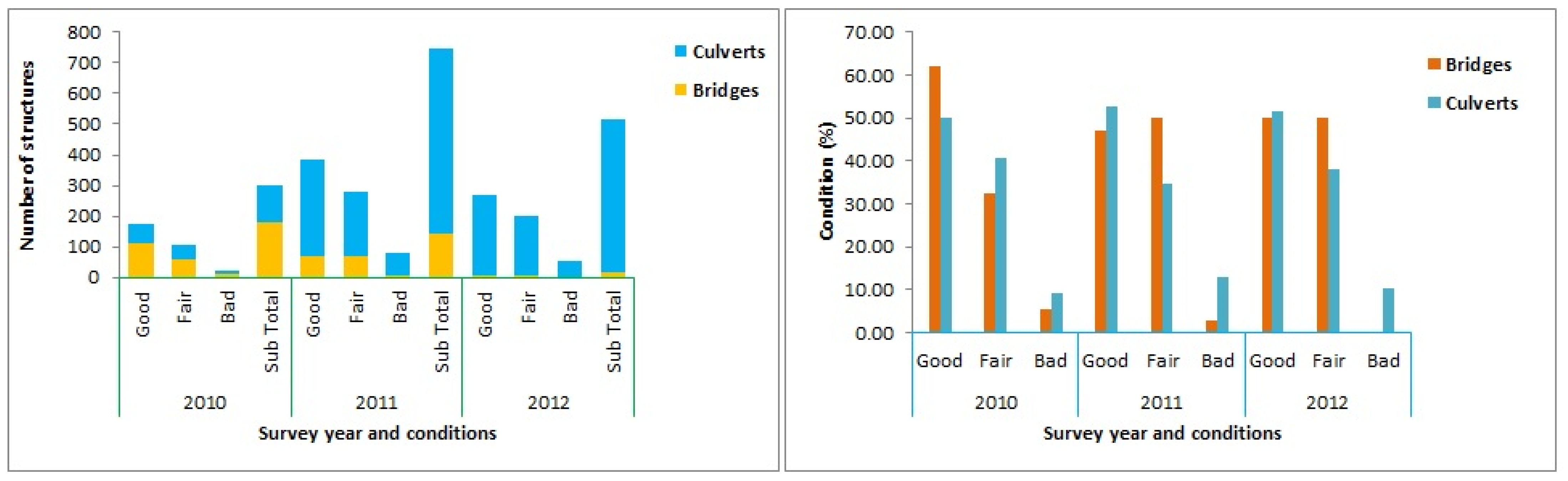
Based on Addis Ababa City Roads Authority’s (AACRA) road asset database information, most cross- and longitudinal drainage infrastructures are affected by solid waste clogging, sediment accumulation, and combined design and construction defects. As per the authority’s annual cross-drainage structures’ inventory and condition assessment report, structures in good condition are not above 50%. Approximately 10% of cross-drainage structures are in bad condition (malfunctional), and the rest are in fair condition, which may fail unless appropriate remedial maintenance and other mitigation measures are taken. Figure 1 shows the condition of cross-drainage infrastructures as per the authority’s annual inventory results.
The objective of this research is to understand urban drainage challenges in response to surface flooding and assessing cross-drainage and longitudinal drainage failure causes and impacts using the analytical hierarchy process (AHP). The study will add value by testing the AHP analysis results on the drainage failure assessment in addition to creating failure mode indices. The research will also add value for drainage designers by proposing local depressions in addition to gutters and cross-fall slopes to reduce surface flow bypasses at higher longitudinal grades. The research did not conduct a detailed investigation of the drainage infrastructures’ failures by taking measurements on failure causes and their respective impacts. Only qualitative measures are made on both failure causes and impacts.
2. Materials and Methods
2.1. Study Area
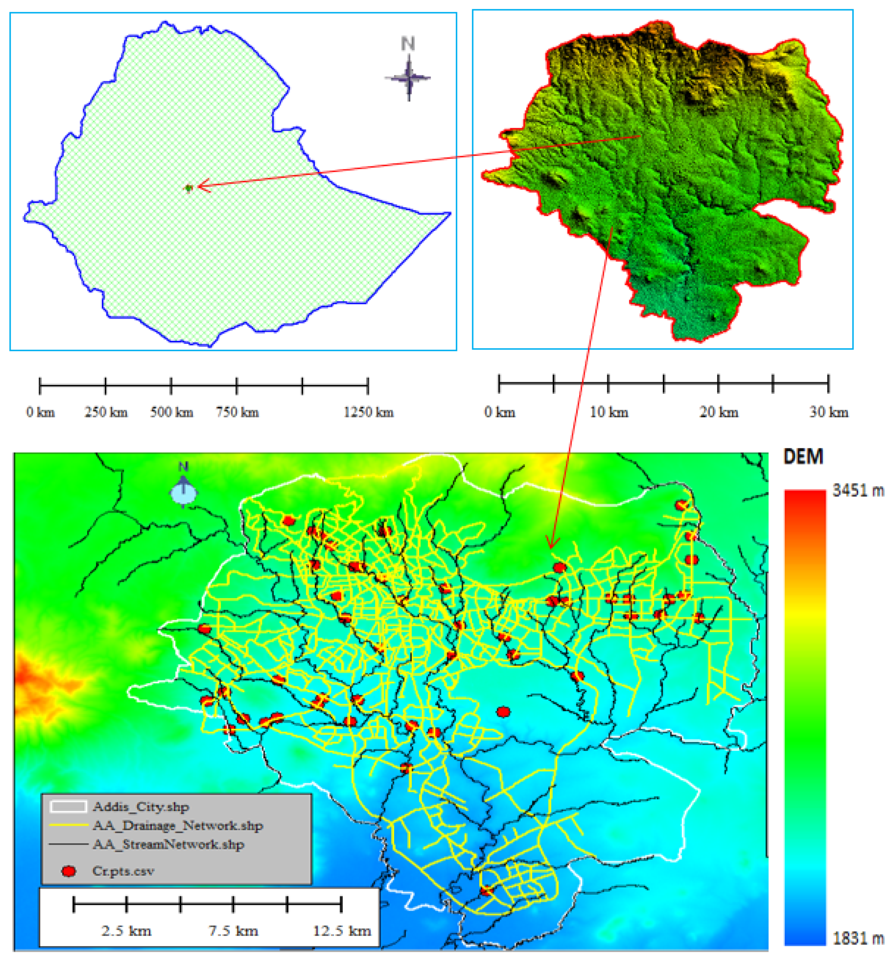
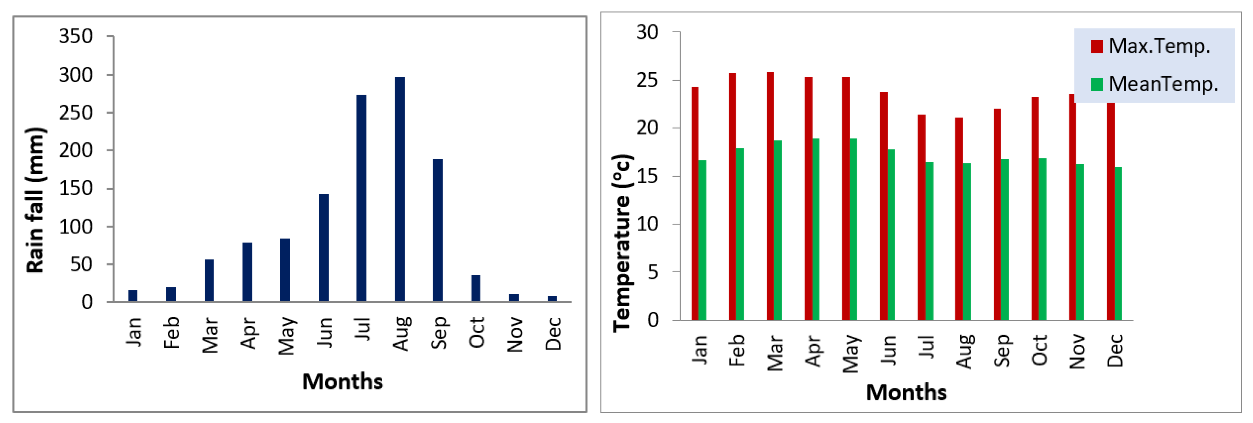
Addis Ababa City is placed between 38°39′43.3″–38°54′50″ E and 8°50′14″–9°5′33″ N, and lies at the border of the Rift Valley zone. The elevation ranges from 3200 masl at Entoto Hill to 2060 masl of the Akaki flood plain. The areal coverage of the city is approximately 527 km2, with annual population growth rate of 4.5% and an average population density of 6900 people/km2. The study area’s climate condition is complex mix of highland climate zones having an average temperature of 15.8 °C and summer single-rainfall season with annual rainfall of 1260 mm. Due to rapid urban development and climate-induced intensive precipitation, flooding became a frequent problem in various areas within the city. Figure 2 and Figure 3 show the study area’s location map and long-term monthly climate conditions, respectively.
2.2. Hydrologic Analysis
Rainfall data with a return period of 50 years are used for the design flood computation of bridges and major culverts, whereas a 25-year return period is used for the remaining culverts, major longitudinal drainage, and outfall systems. A ten-year flood return period is used for the minor longitudinal drainage systems. SCS-CN design flood computation is employed for catchment areas greater than 0.8 km2 and rational formula for areas equal to and less than 0.8 km2 by using General Extreme Value Type I (GEV-I) or Gumbel’s probability plotting method.
2.2.1. Rational Formula
The rational formula assumes that the time of concentration is less than or equal to rainfall duration, uniform rainfall intensity within the catchment area, and homogeneous catchment characteristic (runoff coefficient). The method was applied for catchment areas less than 0.8 km2 and it works by relating peak direct runoff magnitude (Qp) with rainfall intensity (i), watershed area (A), and runoff coefficient (C), using a linear relationship as follows:
where Qp is the peak discharge (m3/s), C is the dimensionless runoff coefficient, i is the rainfall intensity (mm/h), and A is the watershed area (km2).
2.2.2. SCS-CN Method
The SCS-CN method estimates runoff depth (Q) by relating rainfall depth (P) and potential retention of the watershed (S) using a nonlinear relationship as follows:
where is unit peak discharge in m3/s/km2/mm and is estimated as
where A is the drainage area in km2; Q is the runoff depth in mm; Qp is the peak discharge (m3/s); C0, C1, and C2 are regression coefficients obtained from tables or graphs based on various Ia/P ratios; and α is the unit conversion factor, which is 0.000431 in SI units.
For the extreme-value type I distribution, the following expression is used [21]:
where is the design flood of year T, is the return period, is the mean of the data, and is the standard deviation.
2.3. Cross-Drainage Assessment
Most of cross-drainage structures fail hydrologically by overtopping. Hence, failure assessment is performed using hydraulic models of HEC-RAS and HY for bridge and culverts, respectively, using necessary input data collected from site and design documents.
2.3.1. HEC-RAS Model
It is an integrated software system, designed for interactive use in a multitasking, multiuser network environment that comprises a graphical user interface (GUI), separate hydraulics analysis components, data storage and management capabilities, graphics, and reporting facilities [22].
2.3.2. HY Model
It is a GUI culvert modelling toolbox using the C++ programming language. The model performs culvert hydraulic computations. As a result, the presence of many vital features makes culvert analysis and design easier and enables users to analyze the performance of culverts. The model can also perform the analysis of multiple culvert barrels at a single crossing as well as multiple crossings, roadway overtopping at the crossing, and develop report documentations [23].
2.4. Longitudinal Drainage Assessment
A physical drainage condition survey was performed using a prepared checklist for the assessment of the longitudinal drainage components of storm sewers, inlets, manholes, and drainage outfalls. In addition, the FHWA Hydraulic Toolbox is employed to analyze the efficiency of inlets at various input parameters [24].
FHWA Hydraulic Toolbox
The program is a standalone collection of calculators that executes routine hydrologic and hydraulic computations. The toolbox meaningfully extends the basic functionality of the historic version of the FHWA DOS Hydraulic Toolbox and Visual Urban Programs. The program allows a user to perform and save hydraulic calculations in one project file, analyze multiple scenarios, and create plots and reports of these analyses. In our research, the hydraulic toolbox is applied for curb and gutter analysis by providing various combinations of cross-fall slopes, gutters, and local depressions to increase the trapping efficiency of inlets.
2.5. Failure Mode Indices
Cross-drainage failure mode indices are developed using urbanization and catchment characteristics. The urbanization index (URI) is formulated by multiplying the urban development land use factor by the population density. Higher land use values near 100 are given for highly developed commercial areas, and lower values are given to non-developed semi-urban areas. On the other hand, population density factors ranging from 1 (less populated) to 5 (highly populated) are given based on population density data.
2.6. Analytical Hierarchy Process (AHP)
Among many alternative multicriteria decision-making tools, the analytical hierarchy process (AHP) is selected in our study as a result of its wide applicability in engineering and preferences. It is also suggested by researchers such as [25,26,27]. The (AHP) tool is a multicriteria decision-making method that was originally developed by Prof. Thomas L. Saaty. It is a method to derive ratio scales from paired comparisons. The inputs can be obtained from actual measurements or from subjective opinions such as satisfaction feelings and preference. The AHP model allows some minor inconsistencies in judgment because humans are not always perfect. The ratio scales are derived from the principal Eigen vectors, and the consistency index is derived from the principal Eigen value. In this study, parameter weights for both failure causes and impact assessments are obtained from technical interviews and field observations. Failure causes are collected during site investigation for more than 50 cross-drainage structures (bridges and culverts) and more than 3000 longitudinal drainage structure components, such as manholes, inlets, and gutters. For qualitative failure cause and impact analysis, parameters are selected, and weights are given through technical interviews and discussions for pairwise comparison using AHP.
Research reviews on AHP applications are performed for various multicriteria decision-making purposes, such as dam failure risk factors [28]; failure modes and effect analysis in aerospace industry [29]; GIS-based landslide susceptibility evaluation [30]; selection of suitable landfill sites [31]; multicriteria analysis to evaluate landslide risks using application of GIS [32]; multicriteria analysis for flood vulnerable areas by [33]; a failure risk-based culvert renewal prioritization framework [34]; and other related qualitative multicriteria decision-making studies.
3. Results
3.1. Drainage Failure
Both cross- and longitudinal drainage failure causes are analyzed using the analytical hierarchy process (AHP) qualitative multicriteria decision-making model after validating its performance through field observation. In addition, drainage failure impacts and appropriate mitigation measures are analyzed using the same tool.
3.1.1. Longitudinal Drainage Survey Result
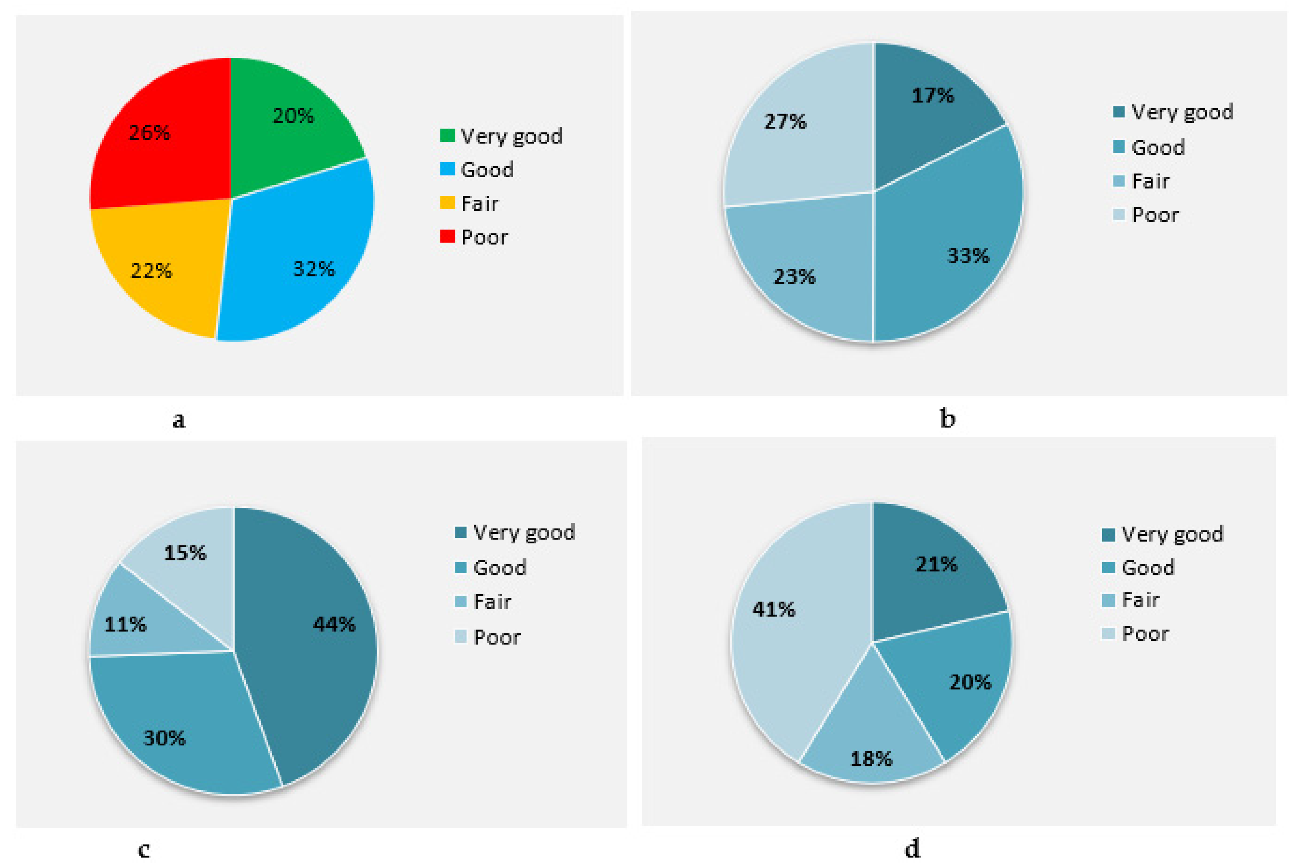
As per our field survey assessment results, most longitudinal drainage structures are affected by problems of solid wastes, debris, and siltation. Figure 4 shows the study survey result of the inlet conditions which are the most vital components of the longitudinal drainage system.
3.1.2. AHP Model Correlation Results
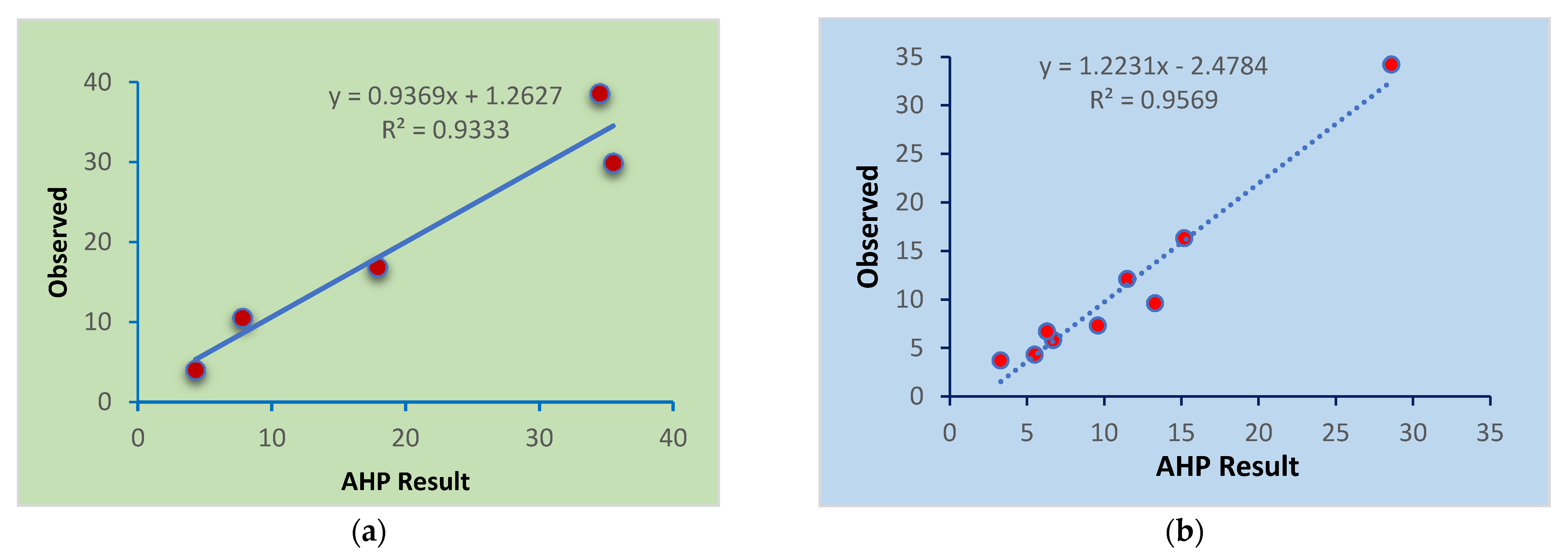
As per verifications performed through site investigation, the AHP results obtained from technical interviews and focal group discussions gave a very strong correlation. As shown in Figure 5, the AHP tool is acceptable and can be used as a good qualitative measure of multicriteria decision making. Correlation results of 0.93 and 0.96 are obtained for cross- and longitudinal drainage infrastructures, respectively.
3.1.3. Drainage Failure Causes
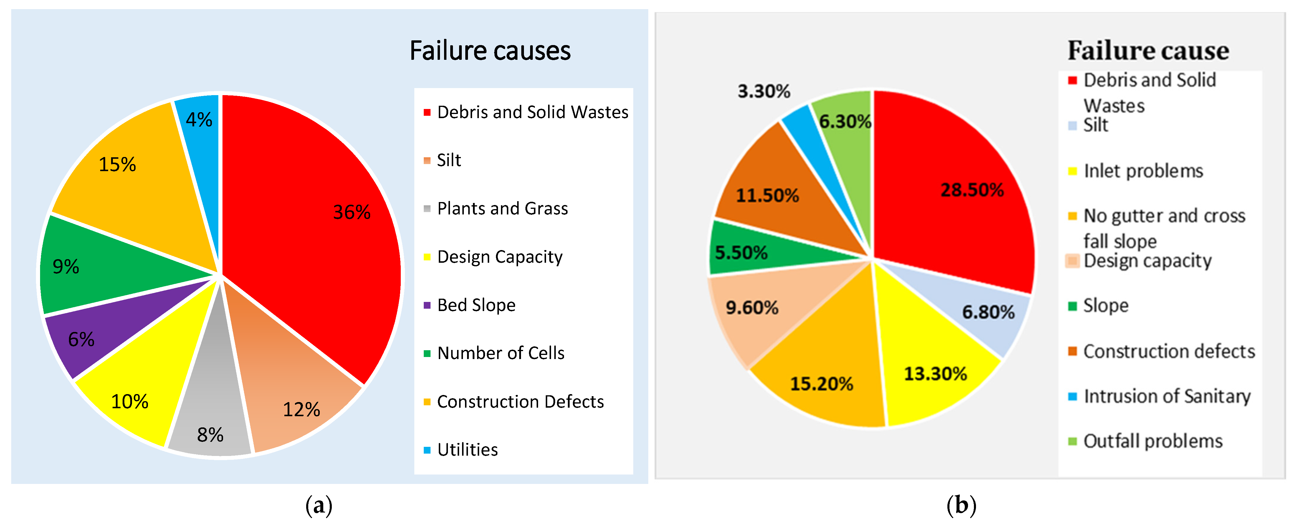
Using an AHP pairwise comparison decision making, the failure cause parameters are selected, and the results in priority order are obtained. Acceptable consistency ratios (CRs) of 2.6% and 2.4% are obtained for the cross- and longitudinal drainage failure cause assessments. As shown in Figure 6, solid wastes are the dominant failure causes for both cross- and longitudinal drainage structures, accounting for approximately 36% and 28.5%, respectively. Construction defects of the crossing structures, accounting for 16%, and a combination of cross-fall and gutter problems of longitudinal drainage systems, accounting for 15.2%, are the second dominant failure causes. Design problems and negligence during construction supervision also have critical impacts on drainage infrastructure failure. Integration and outfall problems of longitudinal drainage systems also have considerable impacts on the failure of longitudinal drainage infrastructures as a result of backwater flow and clogging.
3.1.4. Cross-Drainage Failure Mode Indices
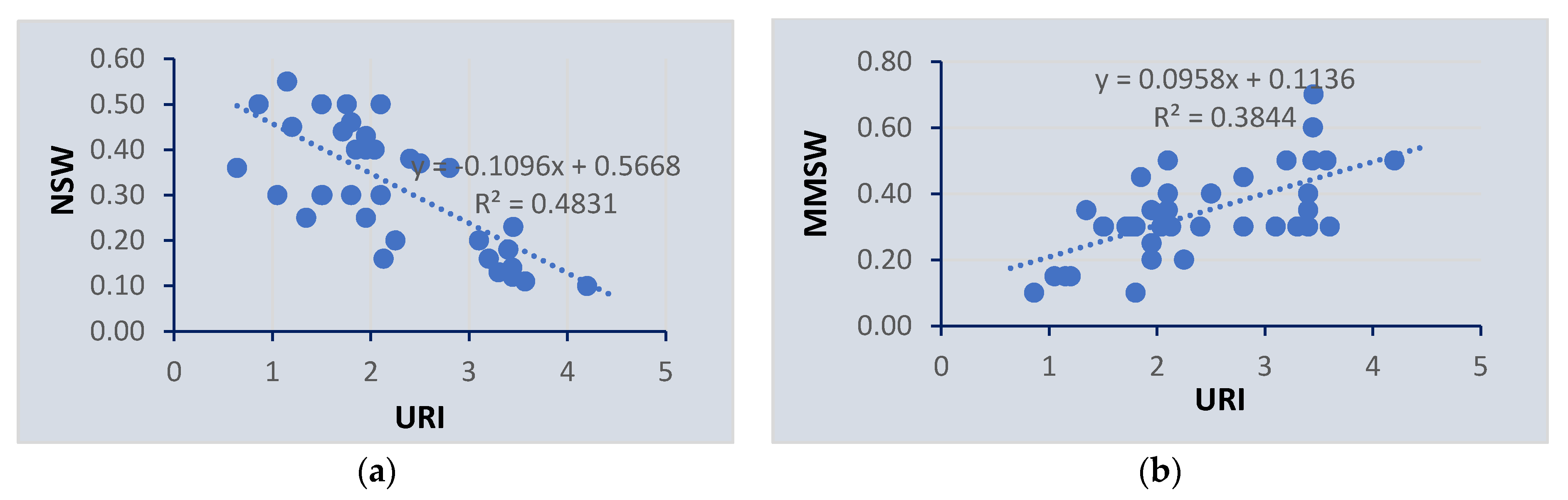
Using the urbanization index, the failure mode of cross-drainage structures is developed as a result of the dominant failure causes of natural solid waste (NSW) and man-made solid waste (MMSW). The results in Figure 7 show that there is a strong positive correlation between urbanization and man-made solid wastes. However, natural solid wastes and debris such as plants, grass, and silts have a negative correlation with urbanization. The results indicate that cross-drainage structures in highly urbanized areas fail due to man-made solid wastes such as plastic, construction, and other wastes. However, crossing structures in semi-urban and less developed areas fail due to silt accumulation and plantation. The results provide insight into the major failure causes during design, construction, and asset management. Due to the significant impact of solid wastes related to urbanization on structural failure, the results provide insight for decision makers to implement appropriate drainage structure follow-up, maintenance, and waste management strategies for the serviceability of infrastructures. For semi-urban and rural catchments, appropriate upstream catchment management strategies should be practiced to protect cross-drainage infrastructures in addition to proper design and construction.
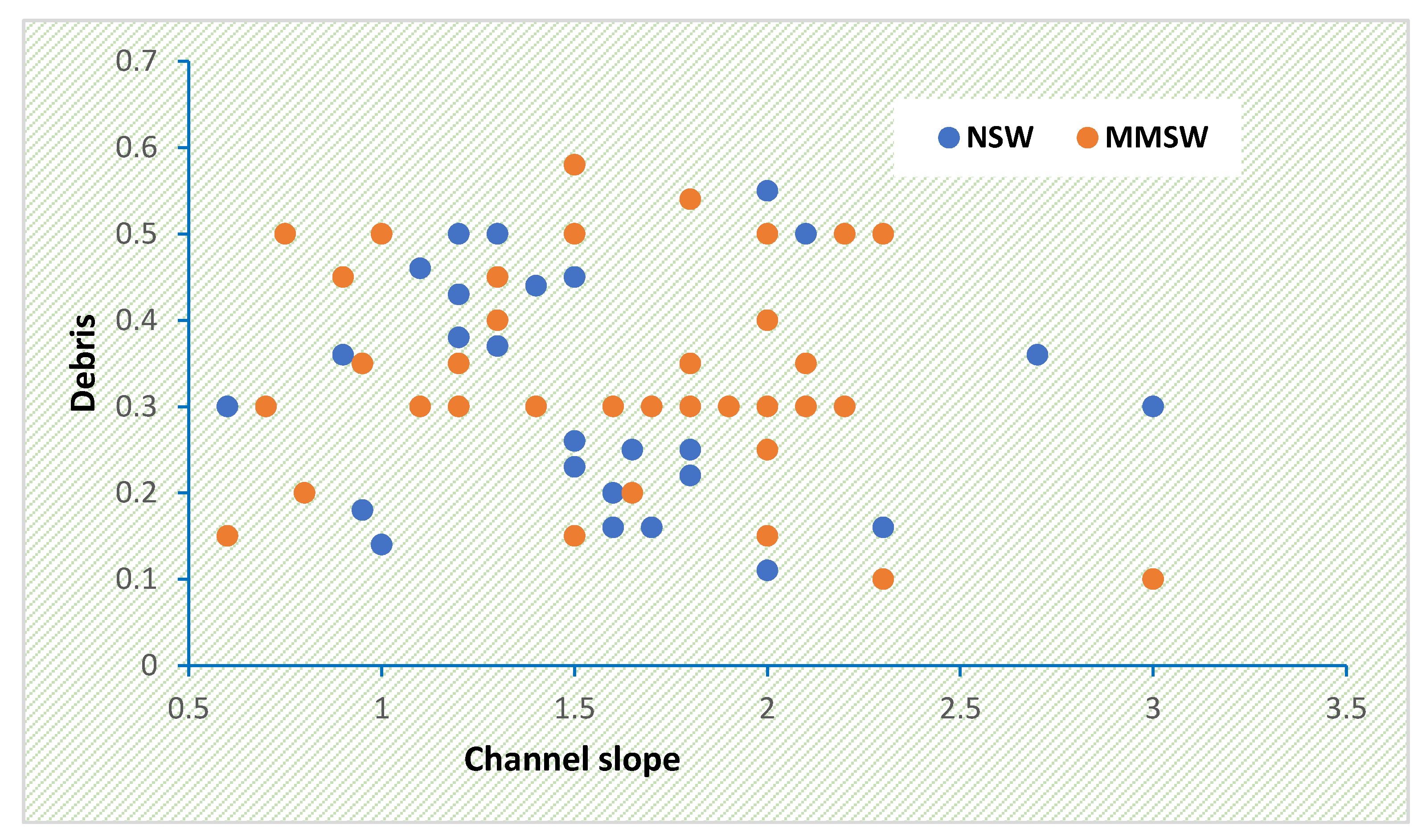
For urban catchments, the channel slopes of cross-drainage and other catchment topographic indices have no significant impact on the failure of cross-drainage structures as a result of debris and other solid wastes, as shown in Figure 8 below.
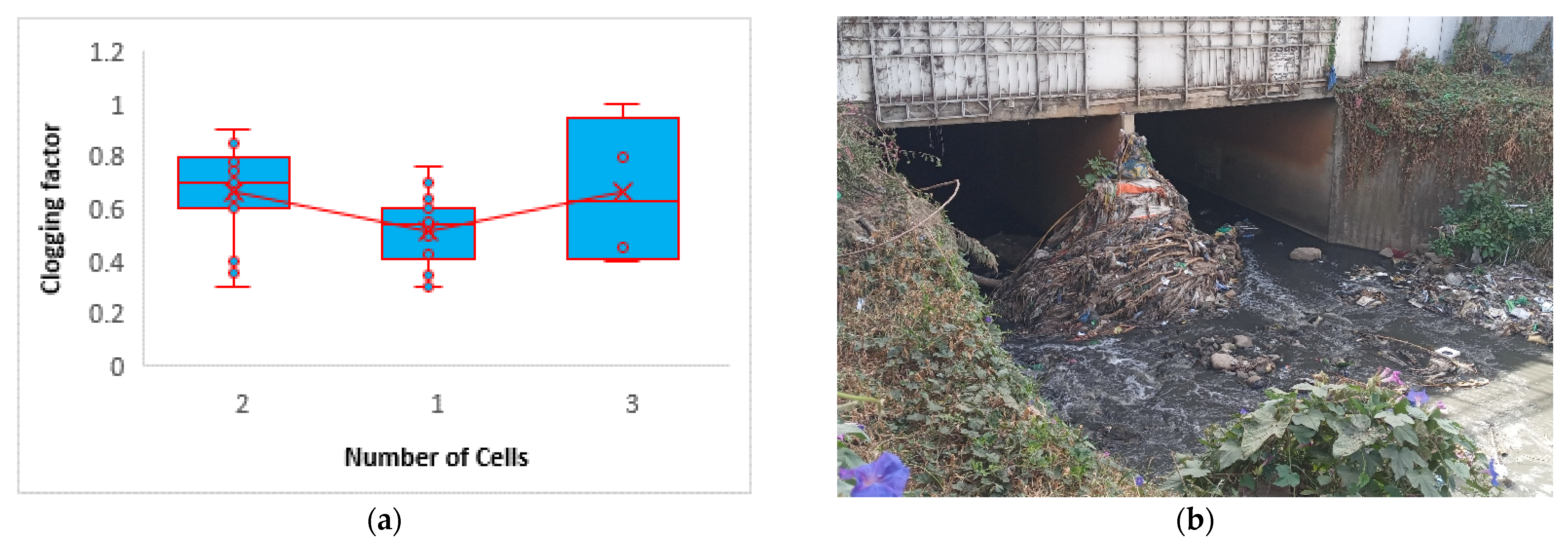
3.1.5. The Impact of Number of Barrels on Cross-Drainage Failure
As shown in the cross-drainage failure cause analysis result obtained by AHP (Figure 6a), the design problem accounts for approximately 20% of the total failure causes, in which 9.2% is the impact of the number of barrels of the crossing structures. As the number of barrels (cells) of the crossing structures increases, the susceptibility of the structure failure will increase as a result of the intermediate barrel column, which traps significant solid wastes and flowing debris such as drifts. Figure 9a shows that the number of barrels and failure are directly proportional. The photo shown in Figure 9b confirmed that the number of cells in the cross-drainage structure has significant adverse impacts on structure failure by blocking flow openings as a result of accumulated solid wastes and drifts. The study results obtained by [17,18] have also indicated the significant impacts of intermediate bridge or culvert columns by trapping drifts and debris that will contribute to flooding problems.
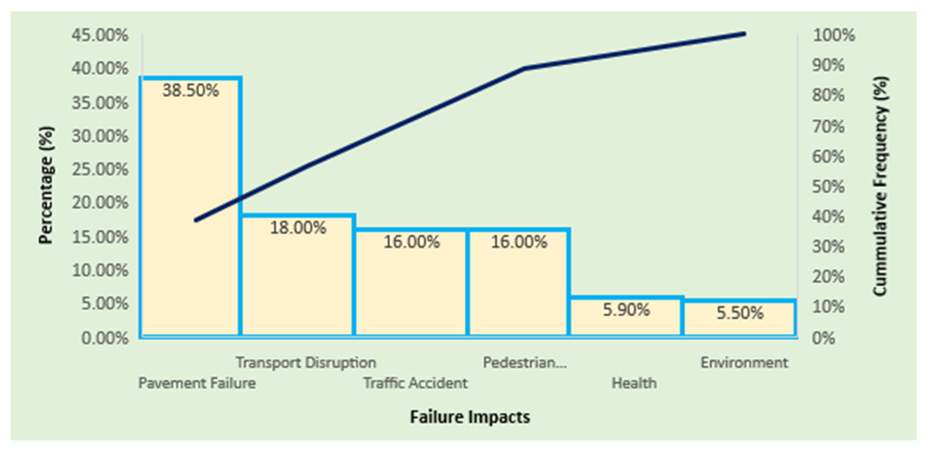
3.2. Drainage Failure Impacts
Failure impacts are analyzed using an AHP pairwise comparison by selecting six important parameters, obtaining an acceptable consistency ratio (CR) of 0.8%. Accordingly, our study results showed that the impact of both cross- and longitudinal drainage infrastructures is high on pavement (road surface) failure by creating potholes and asphalt distresses due to prolonged moisture and stored water through weak asphalt joints. Pavement failure will be aggravated by tire contact on wet pavements. As shown in Figure 10, pavement failure accounts for 38.5% of the total impact parameters, followed by transport disruption accounting for 18%. As per the research review of the poor drainage effect on road pavement performed by [35], road pavement failure is a major adverse effect of drainage, and the other effects are economic impacts due to transport disruption, environmental effects, health problems related to waterborne diseases, and traffic accidents.
According to our study assessment and field observation on transport disruption and traffic jams during rainy and flood events, there is a significant delay in the transport system, which may further affect the economy, social integrity, and health. During our field observation, we confirmed the impact of surface runoff on transport delay during high rainfall events by taking sample transport corridors. As a result, 10 to 30% of time delays are obtained, which may need further detailed studies on the issue.
4. Discussion
4.1. Drainage Failure Causes and Challenges
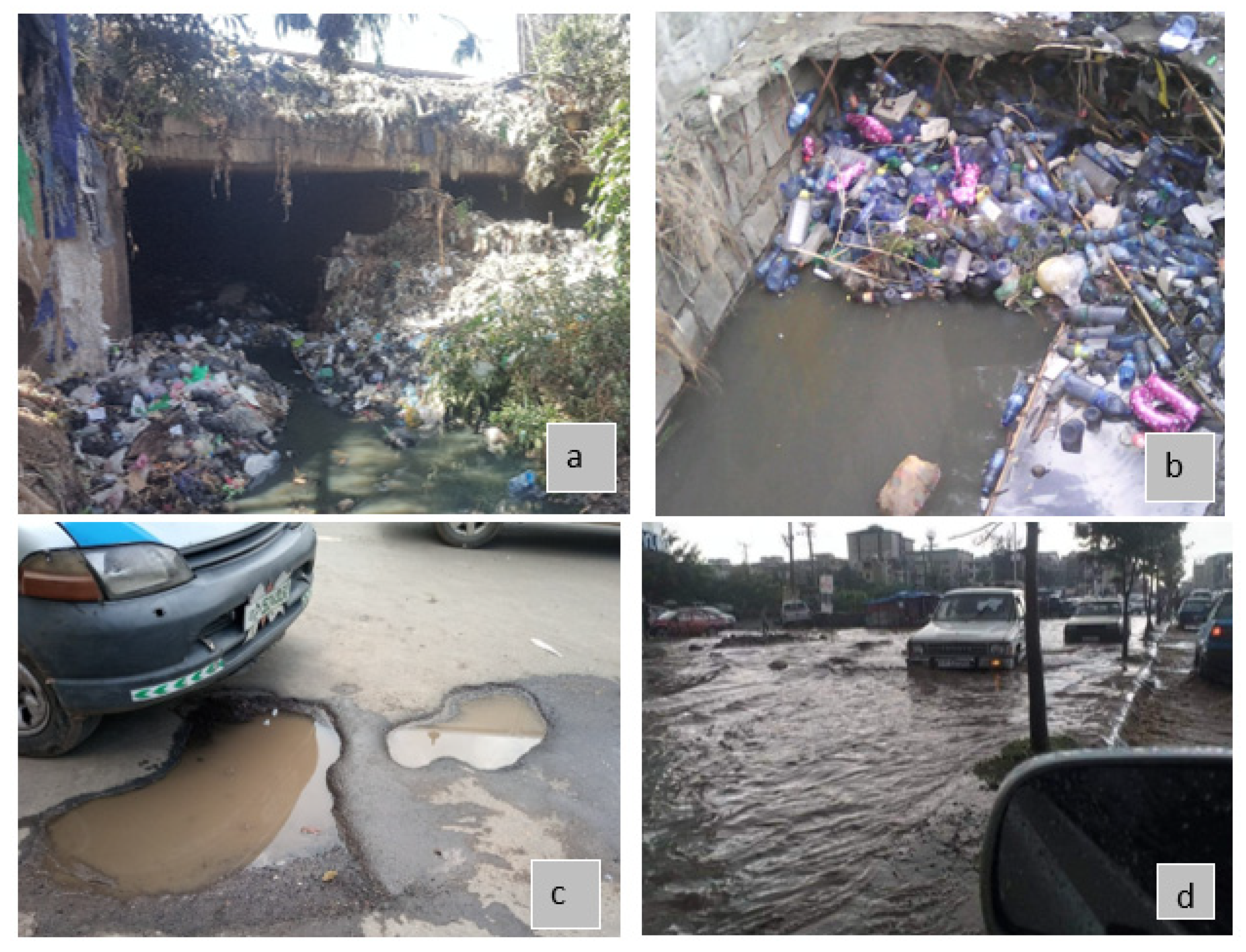
Our research results show that failure causes for both cross- and longitudinal drainage infrastructures need critical consideration for the sustainability of roadways. Research results confirmed that solid wastes are major drainage failure causes and common problems in developing countries, especially in rapidly sprawling urban environments such as Addis Ababa city. Research conducted by [36] indicates that the issue of solid waste is more critical in developing countries than in developed countries. The following photos (Figure 11a,b) show that solid wastes and debris are critical challenges for drainage structures by blocking waterways partially or fully, reducing the discharge efficiency and exposing the roadways to surface flooding. Research carried out by [37] clearly stated the impact of solid wastes by blocking the waterways. The study results showed an approximately 24.6% reduction in discharge efficiency as a result of a 50% blockage of surface drainage inlets and manholes. Another study conducted by [38] on the same study area verified our study result of solid waste problems for drainage failure. The study stated that most drainage infrastructures are filled with illegal solid wastes, which reduce the hydraulic efficiency of the drainage systems, although they are overdesigned. Poor drainage systems will contribute to pavement failures such as potholes, as shown in Figure 11c, as a result of vehicular fatigue in which the pavement is socked by prolonged stored water on the pavement layers. Various studies performed by [39,40,41,42] confirmed that the impact of poor drainage is significant on asphalt and other road layers by creating potholes, cracks, and other drainage-related pavement and road distresses. Our research indicated that drainage-related surface flooding impacts transport systems by disrupting normal transportation, by creating transport jams and traffic accidents. During high-flood events in which drainage systems become inadequate to discharge both surface and riverine floods through longitudinal and cross-drainage facilities, floods will impound on road surfaces, as shown in Figure 11d. In such flood cases and when potholes are available, drivers change their driving lane to escape from them and may crash with another vehicle coming from the opposite direction, leading to traffic accidents and loss of life and property. The study result of [43] supported our drainage failure impact assessment results on transport disruption by delaying travel times due to surface flood accumulation at roadways. Pedestrian transport systems will also be affected by impounded surface flooding and transport jams, which may further lead to traffic accidents. During rainfall and flood events, traffic police may not be available, and traffic jams will be aggravated at malfunctioning traffic signals and road junctions due to the competition of drivers to pass away from the jammed road. As we have observed during our study, some people jump away on the road to pass floods, with critical risks of traffic accidents. Studies carried out by [39,44] supported our research’s drainage failure impact assessment results on pedestrian movement due to accumulated flood depths at surface pedestrian road crossings. The escape of pedestrians will be hindered by heavy-rain-induced floods, leading to health- and traffic-accident-related fatal risks. The study of [45] stated that uncontrolled flash flooding can flow on urban streets and will create a significant hazard to pedestrians and vehicles.
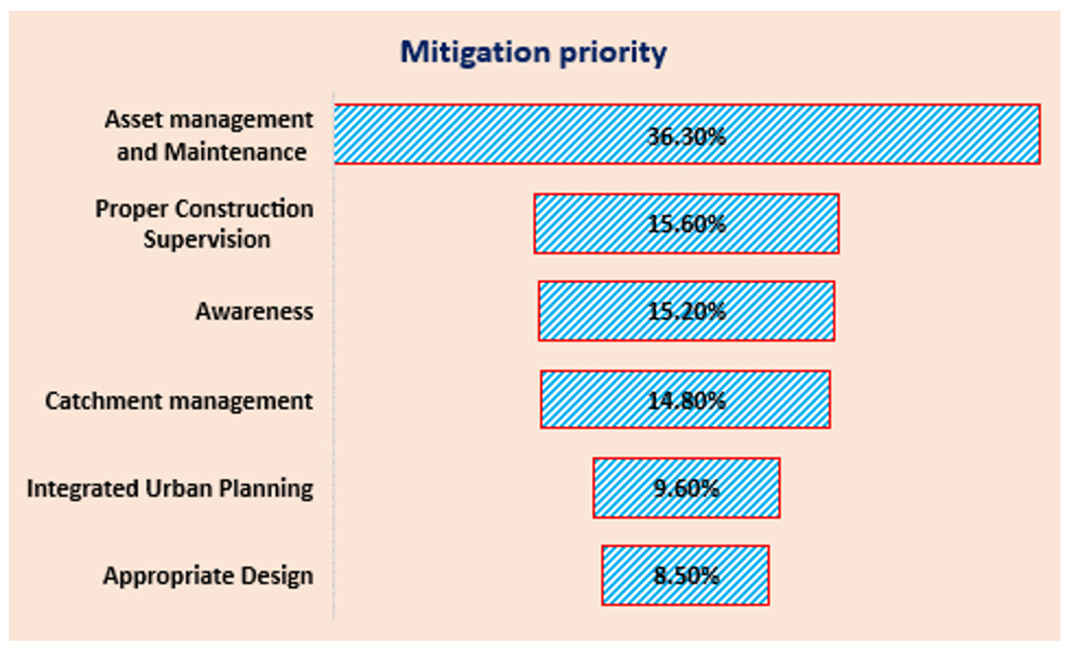
4.2. Drainage Failure Mitigation
To mitigate urban drainage challenges, the AHP qualitative analysis results showed that THE management and periodic maintenance of infrastructure assets is the first priority, accounting for 36.3%, as shown in Figure 12 below. Most failed drainage infrastructures due to solid wastes can be managed through proper asset and solid waste management strategies with periodic maintenance and protection. Proper supervision during the construction of drainage infrastructures has a significant impact on mitigating drainage failures by contributing 15.6% of all mitigation measures. Technical focal group discussions on the issues strongly agreed with implementing proper drainage asset management and solid waste management practices for the safety of drainage infrastructures. Research carried out by [46] supports our study result of drainage failure mitigation through appropriate integrated urban planning and catchment management practices. Other study approaches conducted by [47,48] verified the application of nonstructural drainage management and mitigation measures that are incorporated in our study’s mitigation measure based on integrated urban planning, catchment management, and appropriate designs. The research performed by [20] on the same study area confirmed that nonstructural urban drainage management techniques through low-impact development (LID) practices are effective urban drainage mitigation measures which supports our study’s mitigation recommendation results.
4.3. Gutters and Local Depressions
As a limitation, detailed surveys and measurements are not performed on longitudinal drainage systems. However, qualitative and technical field observations are performed to assess existing longitudinal drainage conditions. We observed that most constructed road infrastructures have no appropriate gutters and no cross-fall slopes, which significantly affect the surface longitudinal drainage systems. As a result, surface floods bypass inlets and flow laterally on road surfaces. The AHP analysis result also showed that the absence of gutters and cross-fall slopes contributed 15.2% to longitudinal drainage failure (Figure 6b). For roadways with longitudinal grades higher than cross-fall slopes in the absence of gutters, the surface flow bypasses inlet systems and will have a significant impact on the road surface and transportation system. Our research has performed an alternative-approach analysis by providing gutters and depressed inlets for steep roadways to increase inlet-trapping efficiencies. Accordingly, the research output indicates that the provision of depressed inlets and gutters has significant impacts on reducing surface-flooding problems by increasing longitudinal inlet-trapping efficiencies.
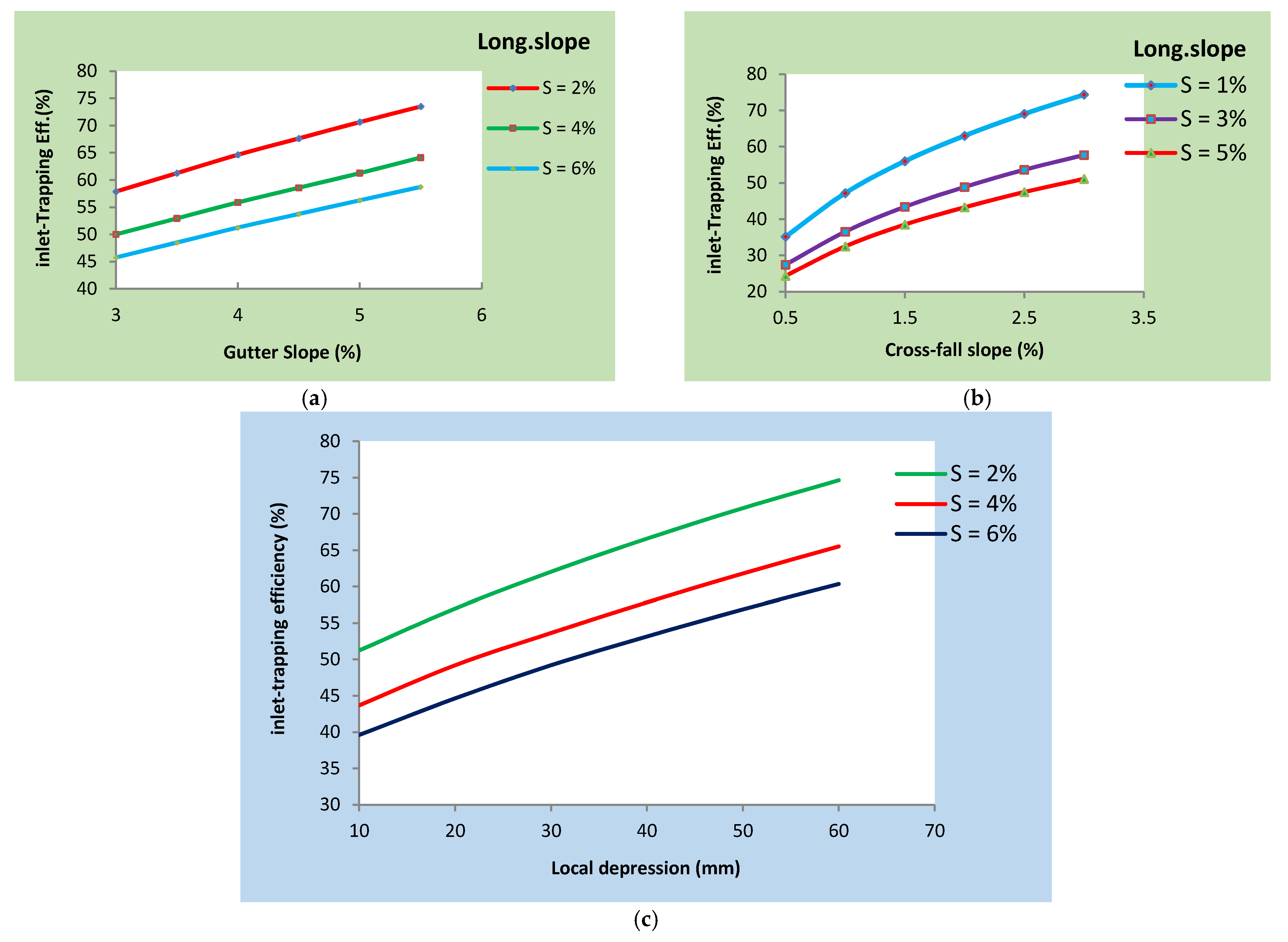
As shown in Figure 13, the inlet-trapping efficiency is significantly dependent on the longitudinal slope of the drainage system in addition to the gutter slopes and pavement cross-fall slopes. The inlet-trapping efficiency is linearly proportional to the gutter and pavement cross-fall slopes. On the other hand, a longitudinal drainage slope decreases the trapping efficiency of inlets unless appropriate local depressions at the inlets are provided in addition to adequate gutter slopes. Most of the observed lateral surface runoff causing flooding on roadways is observed due to a lack of sufficient cross-fall and gutter slopes during construction. As shown in Figure 13a, the provision of gutters with slopes up to 5.5% will increase the flow-trapping efficiency of longitudinal drain systems by 28.24%. On the other hand, for longitudinal drainage systems with relatively higher grades above 5%, the provision of appropriate cross-fall slopes at 2.5% will increase the inlet-trapping efficiency by 94.85% (Figure 13b), which shows that cross-fall slopes within roadways are critical. For roadways with mild slopes up to 4%, the provision of local depressions up to 60 mm, as shown in Figure 13c, will increase the flow-trapping efficiency of longitudinal drains significantly by 50%. Research performed by [49] recommends the provision of appropriate gutters and inlets to remove water logging at road surfaces and increase flow trapping efficiency of drainage inlets. The research supports our results, although it was not verified numerically.
5. Conclusions
Our research results indicated that both natural and man-made solid wastes are the major causes of the failure of cross- and longitudinal drainage systems. Failure modes for highly urbanized areas and semi-urban (less-developed urban) areas are not similar. Debris made up of plastic wastes and food and vegetable wastes, including chat wastes, is a major cause of failure in highly urbanized and commercial areas. Natural solid wastes such as plants, tree branches (drifts), and silts with boulders are dominant failure causes in less-developed semi-urban environments.
There is no significant impact of topography in highly urbanized areas compared to less-urbanized environments. However, land use and land cover have considerable impacts on the failure of drainage systems located in developing and semi-urban areas by contributing silts, tree branches, and plants. According to our research results, the failure of drainage infrastructures will highly affect road pavement by creating continuous potholes, road surface cracks, and other asphalt distresses. Transport disruptions and traffic accidents are also problems highly related to drainage-failure-induced surface flooding.
The AHP multicriteria decision support tool indicates that asset management and maintenance are the first priority of drainage failure mitigation measures. Proper construction supervision during construction, community awareness creation, and upstream catchment management are also other vital mitigation measures for the sustainability of drainage infrastructures. When longitudinal grades are greater than cross-fall slopes, introducing appropriate gutters and local depressions at inlets are design mitigation measures for longitudinal drainage problems that can reduce surface flooding by increasing the trapping efficiencies of longitudinal drain systems.
The study results highly recommend placing a high emphasis on drainage infrastructures starting from the design phase to their final implementation and management. The stakeholders of drainage infrastructures should have a clear strategy, policy, and guideline regarding how to manage the assets and use them with appropriate seasonal inventories, condition surveys, and maintenance plans. The study also recommends conducting detailed research on the socioeconomic and environmental impacts of drainage problems.
Author Contributions
Conceptualization, M.A.J. and A.M.M.; methodology, M.A.J.; software, M.A.J.; validation, M.A.J.; formal analysis, M.A.J.; investigation, M.A.J.; resources, M.A.J.; data curation, M.A.J.; writing—original draft preparation, M.A.J.; writing—review and editing, M.A.J., A.M.M. and B.A.; visualization, M.A.J., A.M.M. and B.A.; supervision, A.M.M. and B.A. All authors have read and agreed to the published version of the manuscript.
Funding
This research received no external funding.
Data Availability Statement
No new data are created.
Acknowledgments
We acknowledge Addis Ababa City Roads Authority Design and the asset & database management directorate offices with their technical staff for their kind support by providing data.
Conflicts of Interest
The authors declare no conflict of interest.
References
- Birhanu, D.; Kim, H.; Jang, C.; Park, S. Flood Risk and Vulnerability of Addis Ababa City Due to Climate Change and Urbanization. Procedia Eng. 2016, 154, 696–702. [Google Scholar] [CrossRef] [Green Version]
- De Risi, R.; Jalayer, F.; De Paola, F.; Carozza, S.; Yonas, N.; Giugni, M.; Gasparini, P. From Flood Risk Mapping toward Reducing Vulnerability: The Case of Addis Ababa. Nat. Hazards 2020, 100, 387–415. [Google Scholar] [CrossRef] [Green Version]
- Miceli, L.B. Effects of Climate Change on the Urban Drainage System of Palermo. 2017, p. 177. Available online: https://iris.unipa.it/bitstream/10447/220724/1/Effects%20of%20climate%20change%20on%20the%20urban%20drainage%20system%20of%20Palermo_Bidera%20Miceli.pdf (accessed on 3 November 2022).
- Yin, J.; Yu, D.; Yin, Z.; Liu, M.; He, Q. Evaluating the Impact and Risk of Pluvial Flash Flood on Intra-Urban Road Network: A Case Study in the City Center of Shanghai, China. J. Hydrol. 2016, 537, 138–145. [Google Scholar] [CrossRef] [Green Version]
- Teshome, M. A Review of Recent Studies on Urban Stormwater Drainage System for Urban Flood Management. Preprints 2020, 100, 295. [Google Scholar] [CrossRef]
- Huong, H.T.L.; Pathirana, A. Urbanization and Climate Change Impacts on Future Urban Flooding in Can Tho City, Vietnam. Hydrol. Earth Syst. Sci. 2013, 17, 379–394. [Google Scholar] [CrossRef] [Green Version]
- Alaneme, G.U.; Dimonyeka, M.U.; Ezeokpube, G.C.; Uzoma, I.I.; Udousoro, I.M. Failure Assessment of Dysfunctional Flexible Pavement Drainage Facility Using Fuzzy Analytical Hierarchical Process. Innov. Infrastruct. Solut. 2021, 6, 122. [Google Scholar] [CrossRef]
- Miller, J.D.; Hutchins, M. The Impacts of Urbanisation and Climate Change on Urban Flooding and Urban Water Quality: A Review of the Evidence Concerning the United Kingdom. J. Hydrol. Reg. Stud. 2017, 12, 345–362. [Google Scholar] [CrossRef] [Green Version]
- Maksimovic, C. General Overview of Urban Drainage Principles and Practice. Urban Drain. Humids Trop. 2002, 40, 226. [Google Scholar]
- Jedwab, R.; Christiaensen, L.; Gindelsky, M. Demography, Urbanization and Development: Rural Push, Urban Pull and…Urban Push? J. Urban Econ. 2017, 98, 6–16. [Google Scholar] [CrossRef] [Green Version]
- Nithila Devi, N.; Sridharan, B.; Kuiry, S.N. Impact of Urban Sprawl on Future Flooding in Chennai City, India. J. Hydrol. 2019, 574, 486–496. [Google Scholar] [CrossRef]
- Armitage, N.P. The Challenges of Sustainable Urban Drainage in Developing Countries. SWITCH Conf. Proceeding Paris 2011, 132–144, 24–26. [Google Scholar]
- Diakakis, M.; Deligiannakis, G.; Andreadakis, E.; Katsetsiadou, K.N.; Spyrou, N.I.; Gogou, M.E. How Different Surrounding Environments Influence the Characteristics of Flash Flood-Mortality: The Case of the 2017 Extreme Flood in Mandra, Greece. J. Flood Risk Manag. 2020, 13, e12613. [Google Scholar] [CrossRef]
- Mukherjee, M.D. Highway Surface Drainage System & Problems of Water Logging In Road Section. Int. J. Eng. Sci. 2014, 3, 44–51. [Google Scholar]
- Abdul Ghani, A.N.; Roslan, N.I.; Abdul Hamid, A.H. Road Submergence during Flooding and Its Effect on Subgrade Strength. Int. J. Geomate 2016, 10, 1848–1853. [Google Scholar] [CrossRef]
- Schmocker, L.; Hager, W.H. Probability of Drift Blockage at Bridge Decks. J. Hydraul. Eng. 2011, 137, 470–479. [Google Scholar] [CrossRef]
- Diehl, T.H. Potential Drift Accumulation at Bridges; U.S. Department of Transportation Federal Highway Administration Research and Development Turner-Fairbank Highway Research Center: Georgetown Pike, VA, USA, 1997; p. 45.
- Lane, K.; Charles-Guzman, K.; Wheeler, K.; Abid, Z.; Graber, N.; Matte, T. Health Effects of Coastal Storms and Flooding in Urban Areas: A Review and Vulnerability Assessment. J. Environ. Public Health 2013, 2013, 913064. [Google Scholar] [CrossRef] [Green Version]
- Jemberie, M.A.; Melesse, A.M. Urban Flood Management through Urban Land Use Optimization Using Lid Techniques, City of Addis Ababa, Ethiopia. Water 2021, 13, 1721. [Google Scholar] [CrossRef]
- Chow, V.T.; Maidment, D.R.; Mays, L.W. Applied Hydrology; McGraw-Hill, Inc.: Austin, TX, USA, 1987; ISBN 0070108102. [Google Scholar]
- Brunner, G.W. HEC-RAS River Analysis System User’s Manual; US Army Corps of Engineers: Washington, DC, USA, 2016. [Google Scholar]
- Burke, C.; Burke, T. Stormwater Drainage Manual 2018; Drainage Services Department, Government of the Hong Kong Special Administrative Region: Hong Kong, 2018.
- Schall, J.D. Hydraulic Design of Highway Culverts, 3rd ed.; United States. Federal Highway Administration: Washington, DC, USA, 2012.
- Basílio, M.P.; Pereira, V.; Costa, H.G.; Santos, M.; Ghosh, A. A Systematic Review of the Applications of Multi-Criteria Decision Aid Methods (1977–2022). Electronics 2022, 11, 1720. [Google Scholar] [CrossRef]
- Widianta, M.M.D.; Rizaldi, T.; Setyohadi, D.P.S.; Riskiawan, H.Y. Comparison of Multi-Criteria Decision Support Methods (AHP, TOPSIS, SAW & PROMENTHEE) for Employee Placement. J. Phys. Conf. Ser. 2018, 953, 012116. [Google Scholar] [CrossRef]
- Zandebasiri, M.; Pourhashemi, M. The Place of AHP Method among the Multi-Criteria Decision Making Methods in Forest Management. Int. J. Appl. Oper. Res. 2016, 6, 75–89. [Google Scholar]
- Daud, N.M.; Hassan, S.H.; Akbar, N.A.; Bakar, A.A.A.; Mohamad, N.A.S.; Manan, E.A.; Hamzah, A.F. Dam Failure Risk Factor Analysis Using AHP Method. In Proceedings of the IOP Conference Series: Earth and Environmental Science, Surakarta, India, 24–25 August 2021; IOP Publishing Ltd.: Bristo, England, 2021; Volume 646. [Google Scholar]
- Dandachi, E.; El Osman, Y. Application of AHP Method for Failure Modes and Effect Analysis (FMEA) in Aerospace Industry for Aircraft Landing System. Master’s Thesis, Eastern Mediterranean University (EMU)-Doğu Akdeniz Üniversitesi (DAÜ), Famagusta, Turkey, 2017. [Google Scholar]
- Abay, A.; Barbieri, G.; Woldearegay, K. GIS-Based Landslide Susceptibility Evaluation Using Analytical Hierarchy Process (AHP) Approach: The Case of Tarmaber District, Ethiopia. Momona Ethiop. J. Sci. 2019, 11, 14. [Google Scholar] [CrossRef] [Green Version]
- Chabuk, A.J.; Al-Ansari, N.; Hussain, H.M.; Knutsson, S.; Pusch, R. GIS-Based Assessment of Combined AHP and SAW Methods for Selecting Suitable Sites for Landfill in Al-Musayiab Qadhaa, Babylon, Iraq. Environ. Earth Sci. 2017, 76, 209. [Google Scholar] [CrossRef] [Green Version]
- Leonardi, G.; Palamara, R.; Manti, F.; Tufano, A. GIS-Multicriteria Analysis Using AHP to Evaluate the Landslide Risk in Road Lifelines. Appl. Sci. 2022, 12, 4707. [Google Scholar] [CrossRef]
- Yahaya, S. Multicriteria Analysis for Flood Vulnerable Areas in Hadejia-Jama’are River Basin, Nigeria. In Proceedings of the American Society for Photogrammetry and Remote Sensing—ASPRS Annual Conference 2008–Bridging the Horizons: New Frontiers in Geospatial Collaboration, Porland, OR, USA, 28 April–2 May 2008; Volume 2, pp. 777–785. [Google Scholar]
- Piratla, K.R.; Jin, H.; Yazdekhasti, S. A Failure Risk-Based Culvert Renewal Prioritization Framework. Infrastructures 2019, 4, 43. [Google Scholar] [CrossRef] [Green Version]
- Toryila, T.M.; Terpase, I.V.; Terlumun, I.E. The Effects of Poor Drainage System on Road Pavement: A Review. Int. J. Innov. Res. Multidiscip. Field 2016, 2, 218–225. [Google Scholar]
- Tucci, C.E.C. Urban Drainage Issues in Developing Countries. Urban Drain. Humid Trop. 2001, 40, 23–40. [Google Scholar]
- Fathy, I.; Abdel-Aal, G.M.; Fahmy, M.R.; Fathy, A.; Zeleňáková, M. The Negative Impact of Blockage on Storm Water Drainage Network. Water 2020, 12, 1974. [Google Scholar] [CrossRef]
- Adugna, D.; Lemma, B.; Jensen, M.B.; Gebrie, G.S. Evaluating the Hydraulic Capacity of Existing Drain Systems and the Management Challenges of Stormwater in Addis Ababa, Ethiopia. J. Hydrol. Reg. Stud. 2019, 25, 100626. [Google Scholar] [CrossRef]
- Patil Prathisthan’, D.Y.; Jalindar, P. Effects of Bad Drainage on Roads Patil Abhijit. Civ. Environ. Res. 2011, 1, 1–8. [Google Scholar]
- Yousuf Ali, M. The Effect of Poor Drainage on Road Performance in Hargeisa. IJSRD—Int. J. Sci. Res. Dev. 2022, 10, 229–234. [Google Scholar]
- Onoyan-Usina, A.; Godwin, Y.; Daudu, L.; Itomi-Ushi, P.; Building, N. Bad Drainage and Its Effects on Road Pavement Conditions in Nigeria. Civ. Environ. Res. 2013, 3, 7–15. [Google Scholar]
- Zumrawi, M.M.E. The Impacts of Poor Drainage on Road Performance in Khartoum. Int. J. Multidiscip. Sci. Emerg. Res. 2014, 3, 901–907. [Google Scholar]
- Pregnolato, M.; Ford, A.; Wilkinson, S.M.; Dawson, R.J. The Impact of Flooding on Road Transport: A Depth-Disruption Function. Transp. Res. Part D Transp. Environ. 2017, 55, 67–81. [Google Scholar] [CrossRef]
- Tang, Y.; Zhou, T.; Zhong, Y.; Hu, S.; Lin, J.; Lin, Z.; Liu, H.; Liu, B.; Zhao, Y.; Wang, Y.; et al. Risk Assessment for Critical Flood Height of Pedestrian Escape in Subway Station. Water 2022, 14, 3409. [Google Scholar] [CrossRef]
- Russo, B.; Gómez, M.; Macchione, F. Pedestrian Hazard Criteria for Flooded Urban Areas. Nat. Hazards 2013, 69, 251–265. [Google Scholar] [CrossRef]
- Ortiz, A.; Velasco, M.J.; Esbri, O.; Medina, V.; Russo, B. The Economic Impact of Climate Change on Urban Drainage Master Planning in Barcelona. Sustainability 2021, 13, 71. [Google Scholar] [CrossRef]
- Lee, E.H.; Lee, Y.S.; Joo, J.G.; Jung, D.; Kim, J.H. Flood Reduction in Urban Drainage Systems: Cooperative Operation of Centralized and Decentralized Reservoirs. Water 2016, 8, 469. [Google Scholar] [CrossRef]
- Paterne, N. Evaluating Drainage Systems Performance and Infiltration Enhancement Techniques as Flood Mitigation Measures in Nyabugogo Catchment, Rwanda. 2018. Available online: http://ir.jkuat.ac.ke/bitstream/handle/123456789/4940/Niyonkuru%20PaterneMSC%20MATHEMATICS-%202019.pdf?sequence=1&isAllowed=y (accessed on 18 January 2023).
- Mukherjee, M. Highway Surface Drainage System & Problems of Water Logging in Road Section; The International Journal of Engineering And Science: West Bengal, India, 2014. [Google Scholar]
- Aranda, J.Á.; Beneyto, C.; Sánchez-Juny, M.; Bladé, E. Efficient Design of Road Drainage Systems. Water 2021, 13, 1661. [Google Scholar] [CrossRef]
Figure 1.
Conditions of cross-drainage structures in number (left) and percentage (right) based on inventory reports from 2011 to 2012 EC.
Figure 1.
Conditions of cross-drainage structures in number (left) and percentage (right) based on inventory reports from 2011 to 2012 EC.

Figure 2.
Study Area: Ethiopia (upper left), Addis Ababa City (upper right), and cross- and longitudinal drainage systems of the study area (bottom).
Figure 2.
Study Area: Ethiopia (upper left), Addis Ababa City (upper right), and cross- and longitudinal drainage systems of the study area (bottom).

Figure 3.
Long-term monthly rainfall (left) and temperature data (right) of the study area (Source: [20]).
Figure 3.
Long-term monthly rainfall (left) and temperature data (right) of the study area (Source: [20]).

Figure 4.
Field survey results of longitudinal drainage inlet conditions for overall inlet conditions (a), curb inlets (b), combined inlets (c) and grate inlets (d).
Figure 4.
Field survey results of longitudinal drainage inlet conditions for overall inlet conditions (a), curb inlets (b), combined inlets (c) and grate inlets (d).

Figure 5.
Correlation result of failure causes through site observation and AHP model results for cross–drainage (a) and longitudinal drainage (b) structures.
Figure 5.
Correlation result of failure causes through site observation and AHP model results for cross–drainage (a) and longitudinal drainage (b) structures.

Figure 6.
Priority of failure causes for cross-drainage (a) and longitudinal drainage (b) systems.

Figure 7.
Correlation of urbanization with natural clogging factors (a) and man-made clogging factors (b).
Figure 7.
Correlation of urbanization with natural clogging factors (a) and man-made clogging factors (b).

Figure 8.
Correlation result of cross-drainage channel slope with man-made (MMSW) and natural solid wastes (debris) (NSW).
Figure 8.
Correlation result of cross-drainage channel slope with man-made (MMSW) and natural solid wastes (debris) (NSW).

Figure 9.
Relation of the number of cross-drainage cells with the solid waste clogging factor (a) and photo showing the impact of the intermediate barrel column on solid waste trapping (b).
Figure 9.
Relation of the number of cross-drainage cells with the solid waste clogging factor (a) and photo showing the impact of the intermediate barrel column on solid waste trapping (b).

Figure 10.
Drainage failure impacts individual percentages and their cumulative frequency.

Figure 11.
Solid wastes, dominant drainage failure causes (a,b), the impacts of poor drainage by creating potholes (c), and traffic disruption due to surface flooding (d).
Figure 11.
Solid wastes, dominant drainage failure causes (a,b), the impacts of poor drainage by creating potholes (c), and traffic disruption due to surface flooding (d).

Figure 12.
Drainage failure mitigation measure results of AHP with priority order.

Figure 13.
Longitudinal drainage inlet-trapping efficiency based on various parameters of: gutter slope (a), cross-fall slope (b), and local depression (c).
Figure 13.
Longitudinal drainage inlet-trapping efficiency based on various parameters of: gutter slope (a), cross-fall slope (b), and local depression (c).

Disclaimer/Publisher’s Note: The statements, opinions and data contained in all publications are solely those of the individual author(s) and contributor(s) and not of MDPI and/or the editor(s). MDPI and/or the editor(s) disclaim responsibility for any injury to people or property resulting from any ideas, methods, instructions or products referred to in the content. |
© 2023 by the authors. Licensee MDPI, Basel, Switzerland. This article is an open access article distributed under the terms and conditions of the Creative Commons Attribution (CC BY) license (https://creativecommons.org/licenses/by/4.0/).
Share and Cite
MDPI and ACS Style
Jemberie, M.A.; Melesse, A.M.; Abate, B. Urban Drainage: The Challenges and Failure Assessment Using AHP, Addis Ababa, Ethiopia. Water 2023, 15, 957. https://doi.org/10.3390/w15050957
AMA Style
Jemberie MA, Melesse AM, Abate B. Urban Drainage: The Challenges and Failure Assessment Using AHP, Addis Ababa, Ethiopia. Water. 2023; 15(5):957. https://doi.org/10.3390/w15050957
Chicago/Turabian StyleJemberie, Mengistu A., Assefa M. Melesse, and Brook Abate. 2023. "Urban Drainage: The Challenges and Failure Assessment Using AHP, Addis Ababa, Ethiopia" Water 15, no. 5: 957. https://doi.org/10.3390/w15050957
Note that from the first issue of 2016, this journal uses article numbers instead of page numbers. See further details here.