
Impacts of Medicanes on Geomorphology and Infrastructure in the Eastern Mediterranean, the Case of Medicane Ianos and the Ionian Islands in Western Greece
 , , ,
, , ,  ,
,  , , , ,
  ,
,
Abstract
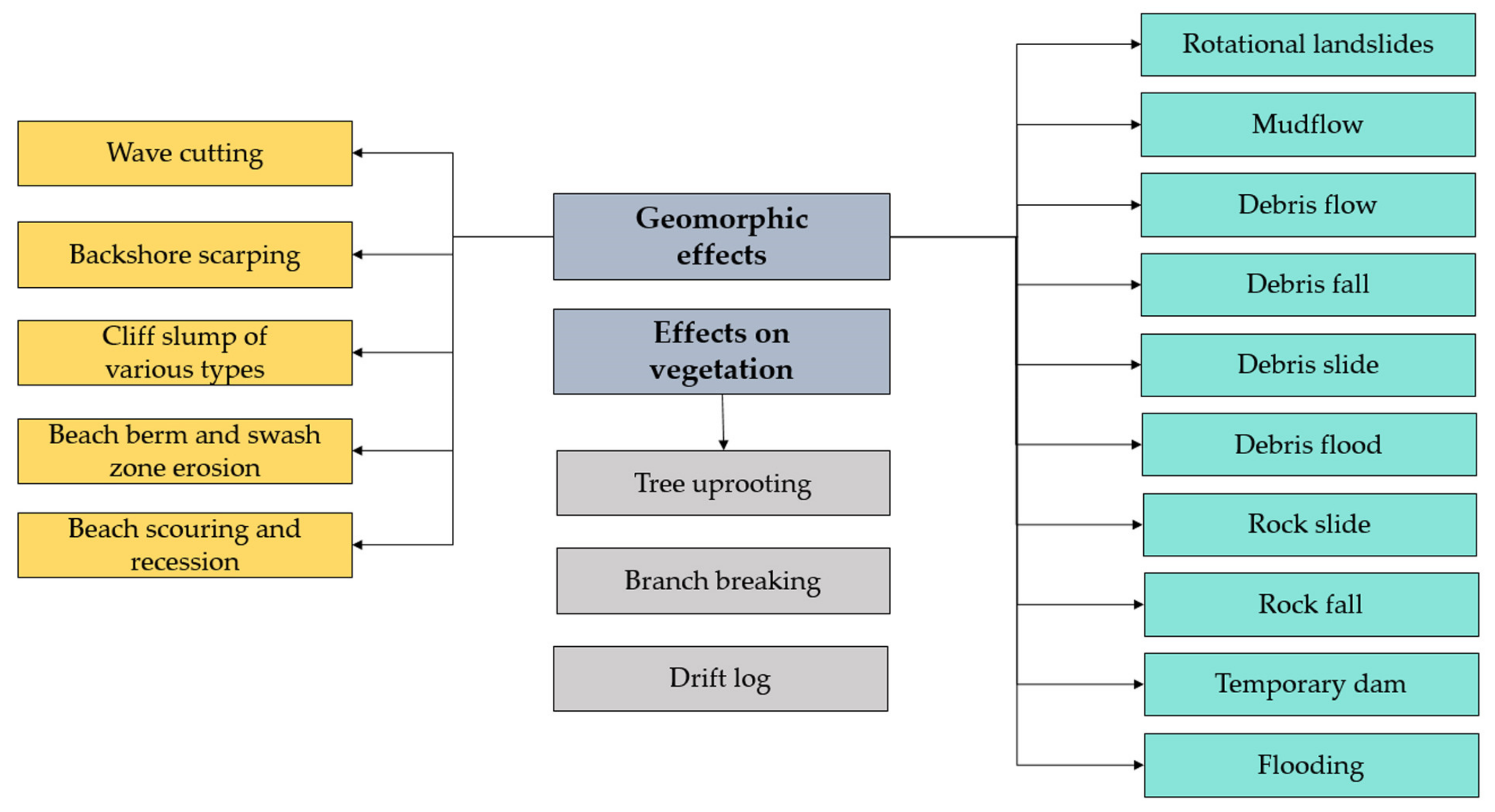
:1. Introduction
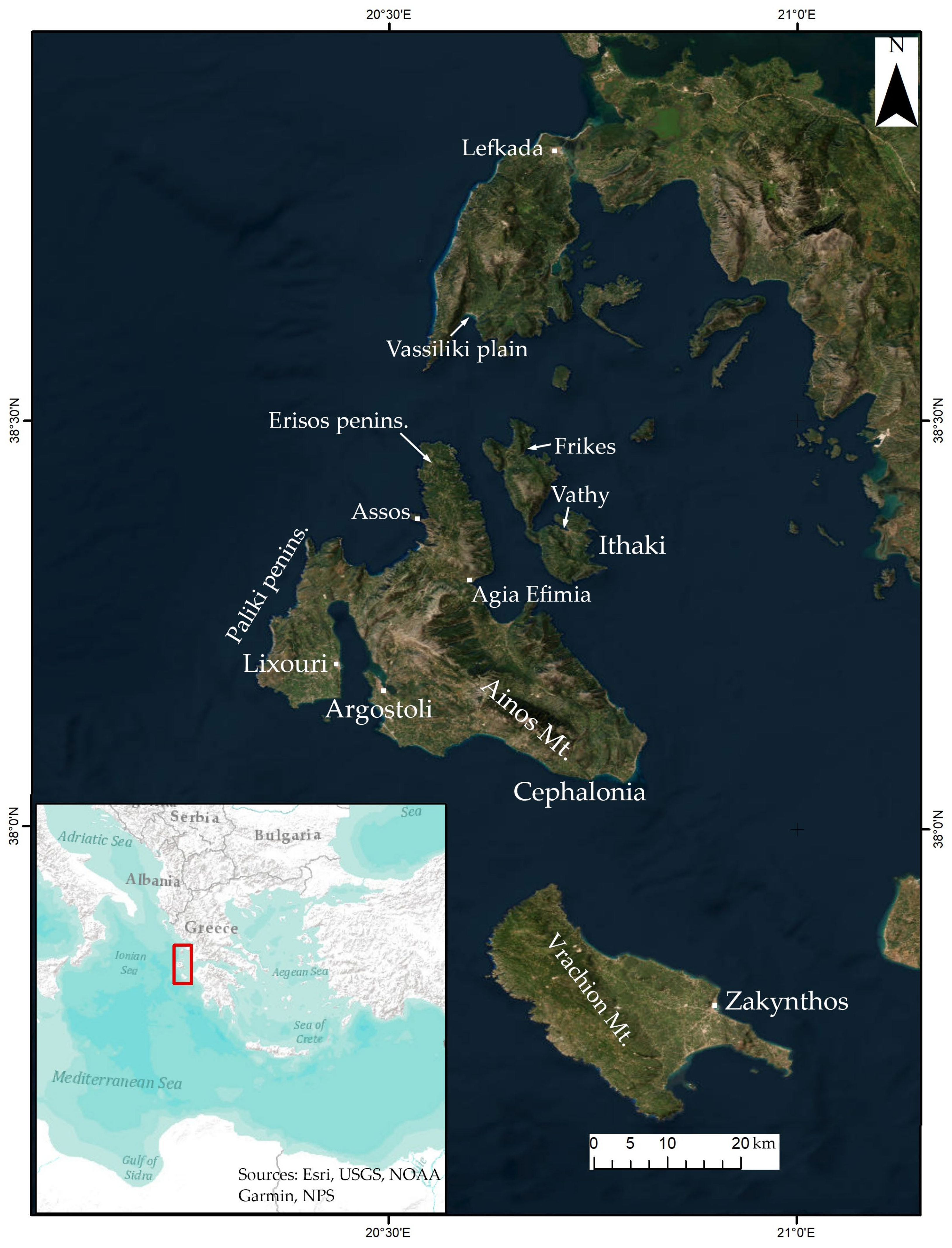
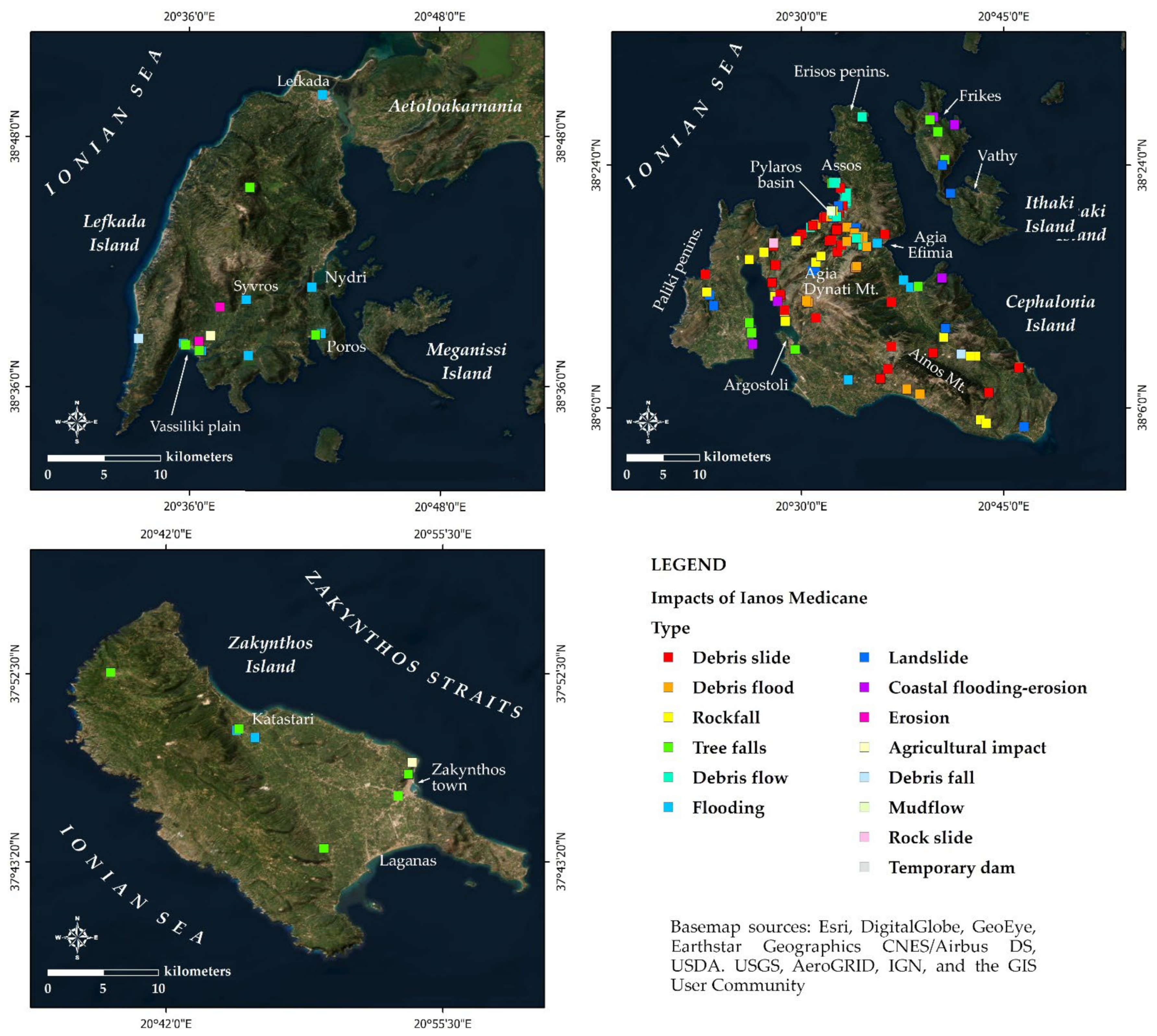
2. Study Area
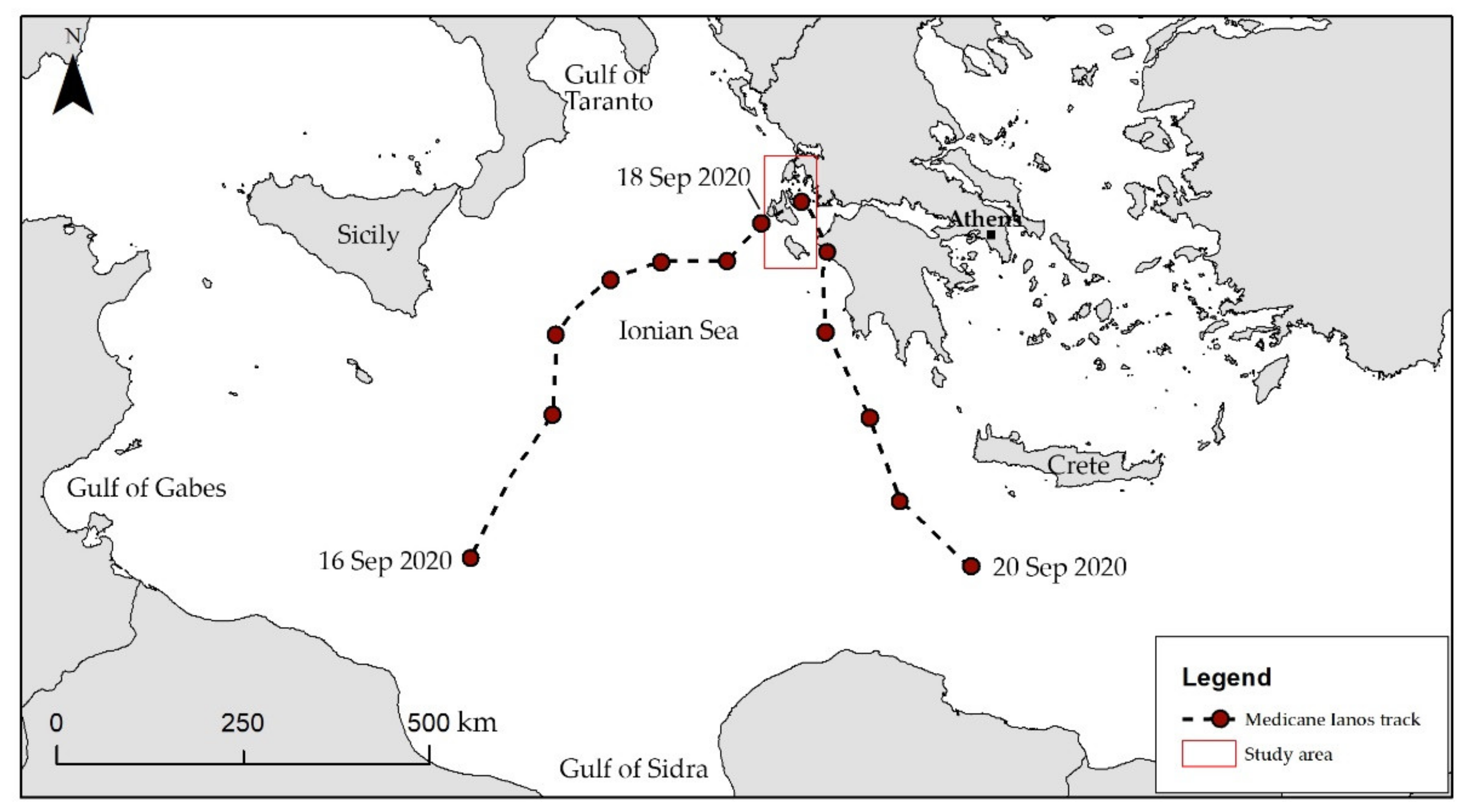
3. Medicane Ianos
4. Data and Methods
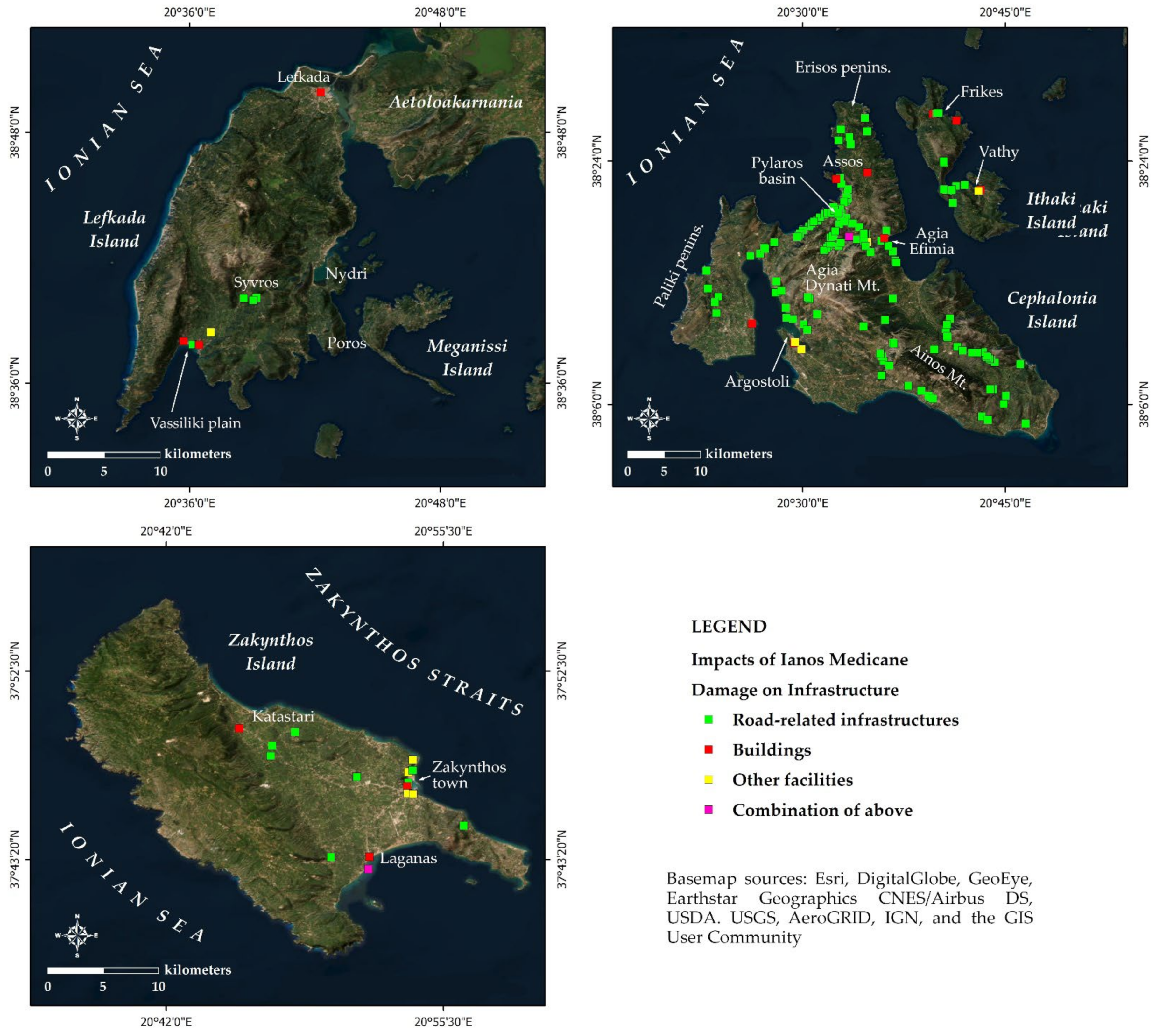
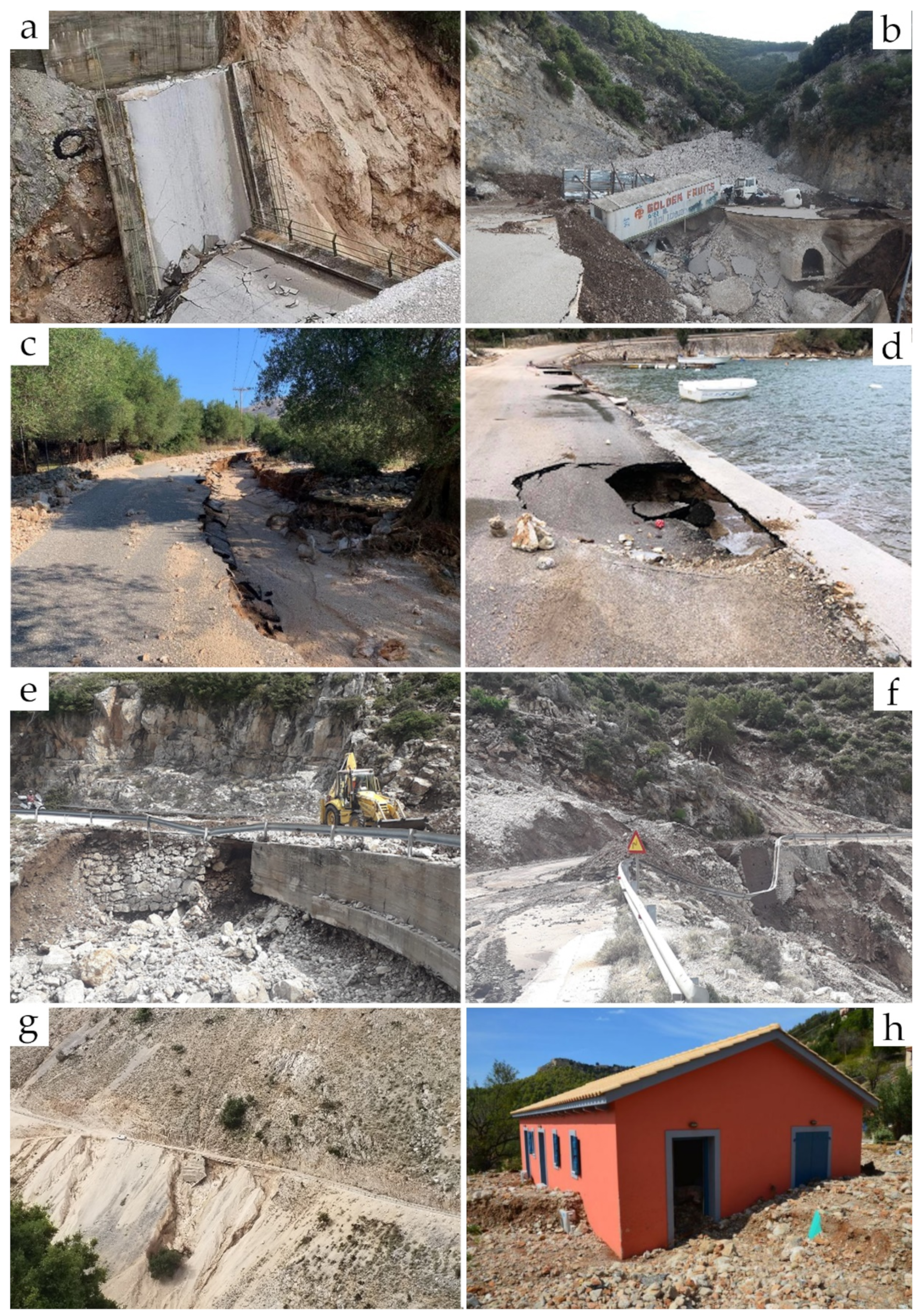
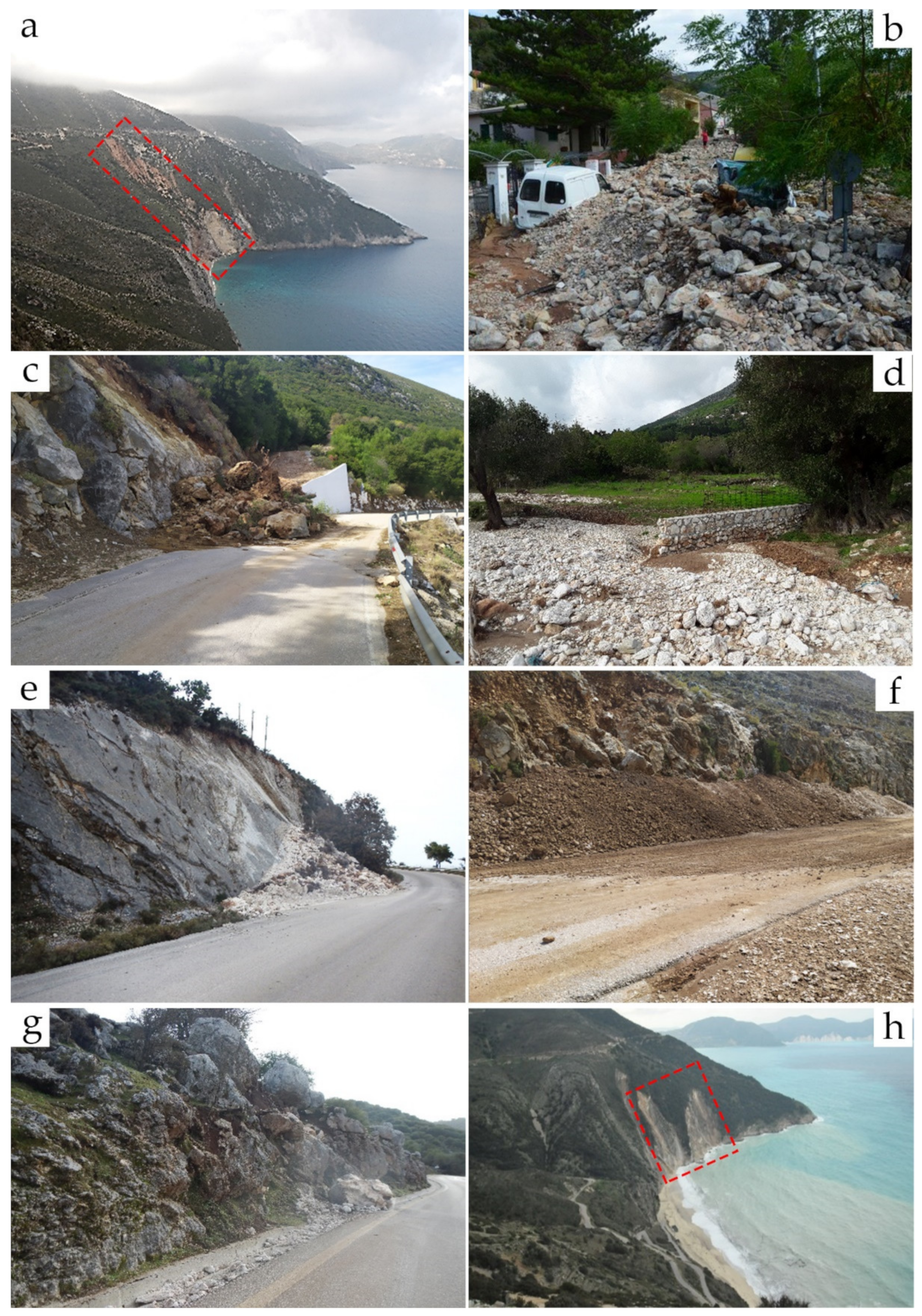
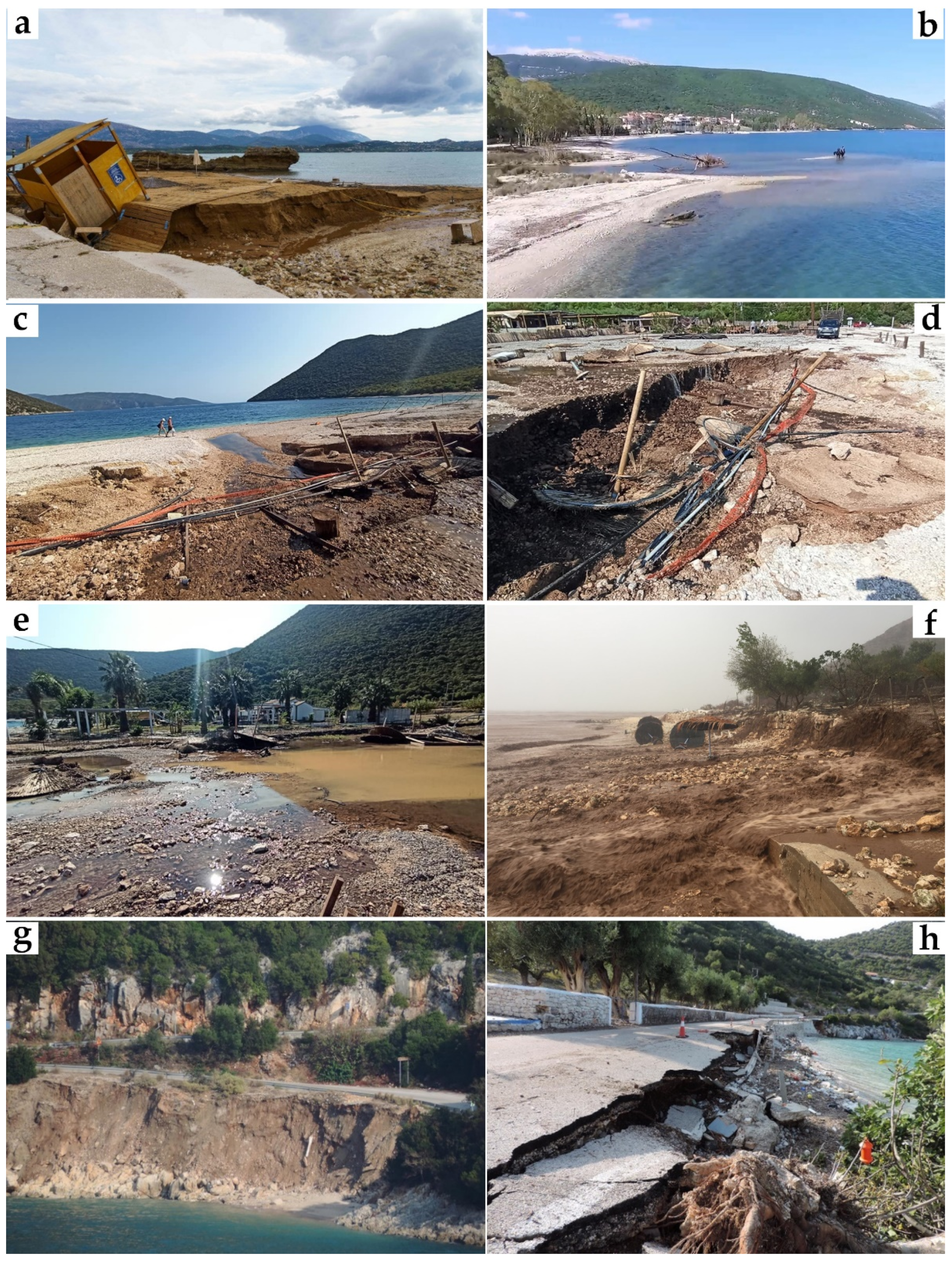
5. Results
6. Discussion
7. Conclusions
Supplementary Materials
Author Contributions
Funding
Data Availability Statement
Conflicts of Interest
References
- Scicchitano, G.; Scardino, G.; Monaco, C.; Piscitelli, A.; Milella, M.; De Giosa, F.; Mastronuzzi, G. Comparing impact effects of common storms and Medicanes along the coast of south-eastern Sicily. Mar. Geol. 2021, 439, 106556. [Google Scholar] [CrossRef]
- Jansa, A.; Genoves, A.; Picornell, M.A.; Campins, J.; Riosalido, R.; Carretero, O. Western Mediterranean cyclones and heavy rain. Part 2: Statistical approach. Meteorol. Appl. 2001, 8, 43–56. [Google Scholar] [CrossRef]
- Androulidakis, Y.; Makris, C.; Mallios, Z.; Pytharoulis, I.; Baltikas, V.; Krestenitis, Y. Storm surges during a Medicane in the Ionian Sea. In Proceedings of the Marine and Inland Waters Research Symposium, Porto Heli, Greece, 16–19 September 2022; Volume 2, pp. 9–14. [Google Scholar]
- Valkaniotis, S.; Papathanassiou, G.; Marinos, V.; Saroglou, C.; Zekkos, D.; Kallimogiannis, V.; Karantanellis, E.; Farmakis, I.; Zalachoris, G.; Manousakis, J.; et al. Landslides Triggered by Medicane Ianos in Greece, September 2020: Rapid Satellite Mapping and Field Survey. Appl. Sci. 2022, 12, 12443. [Google Scholar] [CrossRef]
- Rizza, U.; Canepa, E.; Miglietta, M.M.; Passerini, G.; Morichetti, M.; Mancinelli, E.; Virgili, S.; Besio, G.; De Leo, F.; Mazzino, A. Evaluation of drag coefficients under medicane conditions: Coupling waves, sea spray and surface friction. Atmos. Res. 2021, 247, 105207. [Google Scholar] [CrossRef]
- Rizza, U.; Canepa, E.; Ricchi, A.; Bonaldo, D.; Carniel, S.; Morichetti, M.; Passerini, G.; Santiloni, L.; Puhales, F.S.; Miglietta, M.M. Influence of wave state and sea spray on the roughness length: Feedback on medicanes. Atmosphere 2018, 9, 301. [Google Scholar] [CrossRef] [Green Version]
- Nastos, P.T.; Karavana Papadimou, K.; Matsangouras, I.T. Mediterranean tropical-like cyclones: Impacts and composite daily means and anomalies of synoptic patterns. Atmos. Res. 2018, 208, 156–166. [Google Scholar] [CrossRef]
- Patlakas, P.; Stathopoulos, C.; Tsalis, C.; Kallos, G. Wind and wave extremes associated with tropical-like cyclones in the Mediterranean basin. Int. J. Climatol. 2021, 41, E1623–E1644. [Google Scholar] [CrossRef]
- Toomey, T.; Amores, A.; Marcos, M.; Orfila, A.; Romero, R. Coastal Hazards of Tropical-Like Cyclones Over the Mediterranean Sea. J. Geophys. Res. Ocean. 2022, 127, e2021JC017964. [Google Scholar] [CrossRef]
- Bakkensen, L.A. Estimating the Damages of Mediterranean Hurricanes. J. Extrem. Events 2017, 4, 1–23. [Google Scholar] [CrossRef]
- Tervo, R.; Láng, I.; Jung, A.; Mäkelä, A. Predicting power outages caused by extratropical storms. Nat. Hazards Earth Syst. Sci. 2021, 21, 607–627. [Google Scholar] [CrossRef]
- Loli, M.; Manousakis, J.; Mitoulis, S.A.; Zekkos, D. UAVs for Disaster Response: Rapid Damage Assessment and Monitoring of Bridge Recovery after a Major Flood. Eng. Proc. 2022, 11, 17011. [Google Scholar] [CrossRef]
- Bitan, M.; Zviely, D. Lost value assessment of bathing beaches due to sea level rise: A case study of the Mediterranean coast of Israel. J. Coast. Conserv. 2019, 23, 773–783. [Google Scholar] [CrossRef]
- Remoundou, K.; Koundouri, P.; Kontogianni, A.; Nunes, P.A.L.D.; Skourtos, M. Valuation of natural marine ecosystems: An economic perspective. Environ. Sci. Policy 2009, 12, 1040–1051. [Google Scholar] [CrossRef]
- Thébault, H.; Scheurle, C.; Duffa, C.; Boissery, P. Valuation and sensitivity of socio-economic activities along the French mediterranean coast. Int. J. Sustain. Dev. Plan. 2014, 9, 754–768. [Google Scholar] [CrossRef]
- Vellinga, P.; Leatherman, S.P. Sea level rise, consequences and policies. Clim. Chang. 1989, 15, 175–189. [Google Scholar] [CrossRef]
- Klein, R.J.T.; Nicholls, R.J.; Thomalla, F. Resilience to natural hazards: How useful is this concept? Environ. Hazards 2003, 5, 35–45. [Google Scholar] [CrossRef]
- Taussik, J. Development Plans and the Coastal Zone. Town Plan. Rev. 1996, 67, 397–420. [Google Scholar] [CrossRef]
- Gormsen, E. The impact of tourism on coastal areas. GeoJournal 1997, 42, 39–54. [Google Scholar] [CrossRef]
- Small, C.; Nicholls, J. A global Analysis of Human Settlement in Coastal Zones. J. Coast. Res. 2003, 19, 584–599. [Google Scholar]
- Neumann, B.; Vafeidis, A.T.; Zimmermann, J.; Nicholls, R.J. Future coastal population growth and exposure to sea-level rise and coastal flooding—A global assessment. PLoS ONE 2015, 10, e0131375. [Google Scholar] [CrossRef] [Green Version]
- Mavroulis, S.; Vassilakis, E.; Diakakis, M.; Konsolaki, A.; Kaviris, G.; Kotsi, E.; Kapetanidis, V.; Sakkas, V.; Alexopoulos, J.D.; Lekkas, E.; et al. The Use of Innovative Techniques for Management of High-Risk Coastal Areas, Mitigation of Earthquake-Triggered Landslide Risk and Responsible Coastal Development. Appl. Sci. 2022, 12, 2193. [Google Scholar] [CrossRef]
- Hochman, A.; Marra, F.; Messori, G.; Pinto, J.G.; Raveh-Rubin, S.; Yosef, Y.; Zittis, G. Extreme weather and societal impacts in the eastern Mediterranean. Earth Syst. Dyn. 2022, 13, 749–777. [Google Scholar] [CrossRef]
- Pinna, M.S.; Loi, M.C.; Calderisi, G.; Fenu, G. Extremes Rainfall Events on Riparian Flora and Vegetation in the Mediterranean Basin: A Challenging but Completely Unexplored Theme. Water 2022, 14, 817. [Google Scholar] [CrossRef]
- Jansa, A.; Alpert, P.; Arbogast, P.; Buzzi, A.; Ivancan-Picek, B.; Kotroni, V.; Llasat, M.C.; Ramis, C.; Richard, E.; Romero, R.; et al. MEDEX: A general overview. Nat. Hazards Earth Syst. Sci. 2014, 14, 1965–1984. [Google Scholar] [CrossRef] [Green Version]
- Ragone, F.; Mariotti, M.; Parodi, A.; von Hardenberg, J.; Pasquero, C. A climatological study of Western Mediterranean Medicanes in numerical simulations with explicit and parameterized convection. Atmosphere 2018, 9, 397. [Google Scholar] [CrossRef] [Green Version]
- Cavicchia, L.; von Storch, H.; Gualdi, S. A long-term climatology of medicanes. Clim. Dyn. 2014, 43, 1183–1195. [Google Scholar] [CrossRef]
- Emanuel, K. Genesis and maintenance of “Mediterranean hurricanes”. Adv. Geosci. 2005, 2, 217–220. [Google Scholar] [CrossRef] [Green Version]
- Flaounas, E.; Davolio, S.; Raveh-Rubin, S.; Pantillon, F.; Miglietta, M.M.; Gaertner, M.A.; Hatzaki, M.; Homar, V.; Khodayar, S.; Korres, G.; et al. Mediterranean cyclones: Current knowledge and open questions on dynamics, prediction, climatology and impacts. Weather Clim. Dyn. 2022, 3, 173–208. [Google Scholar] [CrossRef]
- Zhang, Q.; Li, L.; Ebert, B.; Golding, B.; Johnston, D.; Mills, B.; Panchuk, S.; Potter, S.; Riemer, M.; Sun, J.; et al. Increasing the value of weather-related warnings. Sci. Bull. 2019, 64, 647–649. [Google Scholar] [CrossRef] [Green Version]
- Taylor, A.L.; Kox, T.; Johnston, D. Communicating high impact weather: Improving warnings and decision making processes. Int. J. Disaster Risk Reduct. 2018, 30, 1–4. [Google Scholar] [CrossRef]
- Romero, R.; Emanuel, K. Climate change and hurricane-like extratropical cyclones: Projections for North Atlantic polar lows and medicanes based on CMIP5 models. J. Clim. 2017, 30, 279–299. [Google Scholar] [CrossRef] [Green Version]
- Cavicchia, L.; Von Storch, H.; Gualdi, S. Mediterranean tropical-like cyclones in present and future climate. J. Clim. 2014, 27, 7493–7501. [Google Scholar] [CrossRef] [Green Version]
- Tous, M.; Zappa, G.; Romero, R.; Shaffrey, L.; Vidale, P.L. Projected changes in medicanes in the HadGEM3 N512 high-resolution global climate model. Clim. Dyn. 2016, 47, 1913–1924. [Google Scholar] [CrossRef]
- Romera, R.; Gaertner, M.Á.; Sánchez, E.; Domínguez, M.; González-Alemán, J.J.; Miglietta, M.M. Climate change projections of medicanes with a large multi-model ensemble of regional climate models. Glob. Planet. Chang. 2017, 151, 134–143. [Google Scholar] [CrossRef]
- Zittis, G.; Almazroui, M.; Alpert, P.; Ciais, P.; Cramer, W.; Dahdal, Y.; Fnais, M.; Francis, D.; Hadjinicolaou, P.; Howari, F.; et al. Climate Change and Weather Extremes in the Eastern Mediterranean and Middle East. Rev. Geophys. 2022, 60, e2021RG000762. [Google Scholar] [CrossRef]
- IPCC Climate Change 2013: The Physical Science Basis. In Contribution of Working Group I to the Fifth Assessment Report of the Intergovernmental Panel on Climate Change; Cambridge University Press: Cambridge, UK; New York, NY, USA, 2013.
- Agulles, M.; Melo-Aguilar, C.; Jordà, G. Risk of loss of tourism attractiveness in the Western Mediterranean under climate change. Front. Clim. 2022, 4, 1–17. [Google Scholar] [CrossRef]
- Aston Centre for Europe. Sustainable Tourism in the Mediterranean; Aston: Birmingham, UK, 2012; Volume 1. [Google Scholar]
- Amelung, B.; Viner, D. Mediterranean tourism: Exploring the future with the tourism climatic index. J. Sustain. Tour. 2006, 14, 349–366. [Google Scholar] [CrossRef]
- Perry, A.H. Will predicted climate change compromise the sustainability of Mediterranean tourism? J. Sustain. Tour. 2006, 14, 367–375. [Google Scholar] [CrossRef]
- Bartholy, J.; Pongrácz, R.; Pattantyús-Ábrahám, M. Analyzing the genesis, intensity, and tracks of western Mediterranean cyclones. Theor. Appl. Climatol. 2009, 96, 133–144. [Google Scholar] [CrossRef]
- Prezerakos, N.G. The northwest african depressions affecting the south balkans. J. Climatol. 1985, 5, 643–654. [Google Scholar] [CrossRef]
- Kalimeris, A.; Founda, D.; Giannakopoulos, C.; Pierros, F. Long-term precipitation variability in the Ionian Islands, Greece (Central Mediterranean): Climatic signal analysis and future projections. Theor. Appl. Climatol. 2012, 109, 51–72. [Google Scholar] [CrossRef]
- Flocas, A.A.; Giles, B.D. Distribution and intensity of frontal rainfall over Greece. Int. J. Climatol. 1991, 11, 429–442. [Google Scholar] [CrossRef]
- Hellenic National Meteorological Service. Climatic Data for Selected Stations in Greece—Argostoli; Hellenic National Meteorological Service: Ellinikon, Greece, 2023. [Google Scholar]
- Nastos, P.T.; Matsangouras, I.T. Composite Mean and Anomaly of Synoptic Conditions for Tornadic Days over North Ionian Sea (NW Greece). In Advances in Meteorology, Climatology and Atmospheric Physics; Helmis, C.G., Nastos, P.T., Eds.; Springer: Berlin/Heidelberg, Germany, 2012; pp. 639–645. ISBN 9783642291715. [Google Scholar]
- Lagouvardos, K.; Karagiannidis, A.; Dafis, S.; Kalimeris, A.; Kotroni, V. Ianos-A Hurricane in the Mediterranean. Bull. Am. Meteorol. Soc. 2022, 103, E1621–E1636. [Google Scholar] [CrossRef]
- Spyrou, E.; Triantaphyllou, M.V.; Tsourou, T.; Vassilakis, E.; Asimakopoulos, C.; Konsolaki, A.; Markakis, D.; Marketou-Galari, D.; Skentos, A. Assessment of Geological Heritage Sites and Their Significance for Geotouristic Exploitation: The Case of Lefkas, Meganisi, Kefalonia and Ithaki Islands, Ionian Sea, Greece. Geosciences 2022, 12, 55. [Google Scholar] [CrossRef]
- Kotsi, E.; Vassilakis, E.; Diakakis, M.; Mavroulis, S.; Konsolaki, A.; Filis, C.; Lozios, S.; Lekkas, E. Using UAS-Aided Photogrammetry to Monitor and Quantify the Geomorphic Effects of Extreme Weather Events in Tectonically Active Mass Waste-Prone Areas: The Case of Medicane Ianos. Appl. Sci. 2023, 13, 812. [Google Scholar] [CrossRef]
- Mavroulis, S.; Diakakis, M.; Kranis, H.; Vassilakis, E.; Kapetanidis, V.; Spingos, I.; Kaviris, G.; Skourtsos, E.; Voulgaris, N.; Lekkas, E. Inventory of Historical and Recent Earthquake-Triggered Landslides and Assessment of Related Susceptibility by GIS-Based Analytic Hierarchy Process: The Case of Cephalonia (Ionian Islands, Western Greece). Appl. Sci. 2022, 12, 2895. [Google Scholar] [CrossRef]
- Papanikolaou, D.I. The Geology of Greece; Springer: Berlin/Heidelberg, Germany, 2021; ISBN 9783030607302. [Google Scholar]
- Lekkas, E.; Danamos, G.D.; Lozios, S. Neotectonic structure and evolution of Lefkada island. Bull. Geol. Soc. Greece 2001, 34, 157–163. [Google Scholar] [CrossRef] [Green Version]
- Lekkas, E.L.; Danamos, G.D.; Georgios, M. Geological structure and evolution of Kefallonia and Ithaki Islands. Bull. Geol. Soc. Greece 2001, 34, 11–17. [Google Scholar] [CrossRef]
- Scordilis, E.M.; Karakaisis, G.F.; Karacostas, B.G.; Panagiotopoulos, D.G.; Comninakis, P.E.; Papazachos, B.C. Evidence for transform faulting in the Ionian sea: The Cephalonia island earthquake sequence of 1983. Pure Appl. Geophys. Pageoph. 1985, 123, 388–397. [Google Scholar] [CrossRef]
- Louvari, E.; Kiratzi, A.A.; Papazachos, B.C. The Cephalonia Transform Fault and its extension to western Lefkada Island (Greece). Tectonophysics 1999, 308, 223–236. [Google Scholar] [CrossRef]
- Sachpazi, M.; Hirn, A.; Clément, C.; Haslinger, F.; Laigle, M.; Kissling, E.; Charvis, P.; Hello, Y.; Lépine, J.C.; Sapin, M.; et al. Western Hellenic subduction and Cephalonia Transform: Local earthquakes and plate transport and strain. Tectonophysics 2000, 319, 301–319. [Google Scholar] [CrossRef]
- Sakkas, V.; Kapetanidis, V.; Kaviris, G.; Spingos, I.; Mavroulis, S.; Diakakis, M.; Alexopoulos, J.D.; Kazantzidou-Firtinidou, D.; Kassaras, I.; Dilalos, S.; et al. Seismological and ground Deformation Study of the Ionian Islands (W. Greece) during 2014–2018, a Period of Intense Seismic Activity. Appl. Sci. 2022, 12, 2331. [Google Scholar] [CrossRef]
- Lekkas, E.; Mavroulis, S.; Carydis, P.; Alexoudi, V. The 17 November 2015 Mw 6.4 Lefkas (Ionian Sea, Western Greece) Earthquake: Impact on Environment and Buildings; Springer: Berlin/Heidelberg, Germany, 2018; Volume 36, ISBN 1070601804528. [Google Scholar]
- Lekkas, E.L.; Mavroulis, S.D. Earthquake environmental effects and ESI 2007 seismic intensities of the early 2014 Cephalonia (Ionian Sea, western Greece) earthquakes (January 26 and February 3, Mw 6.0). Nat. Hazards 2015, 78, 1517–1544. [Google Scholar] [CrossRef]
- Mavroulis, S.; Stanota, E.S.; Lekkas, E. Evaluation of environmental seismic intensities of all known historical and recent earthquakes felt in Zakynthos Island, Greece using the Environmental Seismic Intensity (ESI 2007) scale. Quat. Int. 2019, 532, 1–22. [Google Scholar] [CrossRef]
- IGUR. The Devastating Earthquakes of the Ionian Islands in August 1953: Proposal for the Reconstruction of Cities, Towns and Villages of the Earthquake-Affected Islands; Institute of Geology and Underground Research (IGUR): Athens, Greece, 1954. [Google Scholar]
- Mavroulis, S.; Carydis, P.; Alexoudi, V.; Grambas, A.; Lekkas, E. The January-February 2014 Cephalonia (Ionian Sea, Western Greece) Earthquakes: Tectonic and Seismological Aspects. In Proceedings of the 16th World Conference on Earthquake, 16WCEE, Santiago, Chile, 9–13 January 2017. [Google Scholar]
- Mavroulis, S.; Diakakis, M.; Kotsi, E.; Vassilakis, E.; Lekkas, E. Susceptibility and hazard assessment in the Ionian Islands for highlighting sites of significant earthquake-related hazards. In Proceedings of the Safe Corfu 2019 Proceedings, SafeGreece, Corfu, Greece, 6–9 November 2019; Volume 1, pp. 13–16. [Google Scholar]
- ELSTAT. Census Results of Population and Housing 2021; ELSTAT: Athens, Greece, 2021. [Google Scholar]
- Lekkas, E.; Nastos, P.; Cartalis, C.; Diakakis, M.; Gogou, M.; Mavroulis, S.; Spyrou, N.-I.; Kotsi, E.; Vassilakis, E.; Katsetsiadou, K.-N.; et al. Impact of Medicane “IANOS” (September 2020). Newsletter of Environmental, Disaster and Crisis Management Strategies, 28 October 2020. [Google Scholar]
- Velesioti, A. NewMoney; Athens, Greece November 2020; pp. 1–7.
- Prat, A.C.; Federico, S.; Torcasio, R.C.; D’adderio, L.P.; Dietrich, S.; Panegrossi, G. Evaluation of the sensitivity of medicane ianos to model microphysics and initial conditions using satellite measurements. Remote Sens. 2021, 13, 4984. [Google Scholar] [CrossRef]
- Lagouvardos, K.; Kotroni, V.; Bezes, A.; Koletsis, I.; Kopania, T.; Lykoudis, S.; Mazarakis, N.; Papagiannaki, K.; Vougioukas, S. The automatic weather stations NOANN network of the National Observatory of Athens: Operation and database. Geosci. Data J. 2017, 4, 4–16. [Google Scholar] [CrossRef]
- Special Secretariat for Water Flood Risk Management Plans of the Hydrological Basins of North Peloponnese-Intensity-Duration-Frequency Curves; Greek Ministry of Environment and Energy: Athens, Greece, 2018.
- Diakakis, M.; Deligiannakis, G.; Antoniadis, Z.; Melaki, M.; Katsetsiadou, N.K.; Andreadakis, E.; Spyrou, N.I.; Gogou, M. Proposal of a flash flood impact severity scale for the classification and mapping of flash flood impacts. J. Hydrol. 2020, 590, 125452. [Google Scholar] [CrossRef]
- Lekkas, E.L.; Andreadakis, E.; Kostaki, I.; Kapourani, E. A proposal for a new integrated Tsunami intensity scale (ITIS-2012). Bull. Seismol. Soc. Am. 2013, 103, 1493–1502. [Google Scholar] [CrossRef]
- Koujianos, J.; Danezis, E.; Koujianos, P.; Charitonidis, A.; Efthimiou, A. Consulting Services for Updating the Agia Efimia Anti-Flood Pipeline Studies; Regional Authorities of Kefallinia and Ithaki: Argostoli, Greece, 2020. [Google Scholar]
- Koujianos, J.; Danezis, E.; Koujianos, P.; Charitonidis, A.; Efthimiou, A. Master Plan for the Flood Protection of Pylaros River Basin; Regional authorities of Kefallinia and Ithaki: Argostoli, Greece, 2020. [Google Scholar]
- Regional Authorities of Kefallinia and Ithaki Managing Issues Caused by the 17th and 18th September 2020 Weather Event; Regional Authorities of Kefallinia and Ithaki: Argostoli, Greece, 2020.
- Naoum, G. Impacts of Mediterranean Cyclones in the Ionian Islands: The Case of “Ianos”. MSc Thesis, National and Kapodistrian University of Athens, Athens, Greece, 2023. [Google Scholar]
- Zekkos, D.; Zalachoris, G.; Alvertos, A.E.; Amatya, P.M.; Blunts, P.; Clark, M.; Dafis, S.; Farmakis, I.; Ganas, A.; Hille, M.; et al. The September 18–20 2020 Medicane Ianos Impact on Greece—Phase I Reconnaissance Report. Geotechnical Extreme Events Reconnaissance Report, GEER-068; Geotechnical Extreme Events Reconnaissance Association: Alameda County, CA, USA, 2020. [Google Scholar]
- Greek National Newspapers Archive. National Newspapers Microfilm Database of the Library of the Hellenic Parliament; Hellenic Parliament: Athens, Greece, 2019. [Google Scholar]
- National Library Newspapers Collection. E-efimeris: Digital Newspapers Collection of the Greek National Library; Greek National Library: Athens, Greece, 2022. [Google Scholar]
- Komar, P.D.; Moore, J.R. Handbook of Coastal Processes and Erosion; Komar, P.D., Moore, J.R., Eds.; CRC Press: London, UK, 2018; ISBN 9781315893808. [Google Scholar]
- Clarke, B.J.; Otto, F.E.L.; Jones, R.G. Inventories of extreme weather events and impacts: Implications for loss and damage from and adaptation to climate extremes. Clim. Risk Manag. 2021, 32, 100285. [Google Scholar] [CrossRef]
- Mastrandrea, M.D.; Tebaldi, C.; Snyder, C.W.; Schneider, S.H. Current and future impacts of extreme events in California. Clim. Chang. 2011, 109, 43–70. [Google Scholar] [CrossRef]
- Marinos, P.G.; Hoek, E. A geologically friendly tool for rock mass strength estimation. In Proceedings of the GeoEng2000 at the International Conference on Geotechnical and Geological Engineering; Technomic Publishers: Lancaster, PA, USA, 2000; Volume 1, pp. 1422–1446. [Google Scholar]
- Douglass, S.L.; Webb, B.M. Highways in the Coastal Environment, 3rd ed.; U.S. Department of Transportation: Washington, DC, USA, 2020. [Google Scholar]
- Fortelli, A.; Fedele, A.; De Natale, G.; Matano, F.; Sacchi, M.; Troise, C.; Somma, R. Analysis of sea storm events in the mediterranean sea: The case study of 28 december 2020 sea storm in the gulf of Naples, Italy. Appl. Sci. 2021, 11, 11460. [Google Scholar] [CrossRef]
- Link, O.; Mignot, E.; Roux, S.; Camenen, B.; Escauriaza, C.; Chauchat, J.; Brevis, W.; Manfreda, S. Scour at bridge foundations in supercritical flows: An analysis of knowledge gaps. Water 2019, 11, 1656. [Google Scholar] [CrossRef] [Green Version]
- Diakakis, M.; Lekkas, E.; Stamos, I.; Mitsakis, E. Vulnerability of transport infrastructure to extreme weather events in small rural catchments. Eur. J. Transp. Infrastruct. Res. 2016, 16, 114–127. [Google Scholar] [CrossRef]
- Chen, H.; Zhang, G.; Chang, Z.; Wen, L.; Gao, W. Failure Analysis of a Highway Cut Slope with Anti-Slide Piles. Geofluids 2021, 2021, 6622214. [Google Scholar] [CrossRef]
- Oh, S.; Lu, N. Slope stability analysis under unsaturated conditions: Case studies of rainfall-induced failure of cut slopes. Eng. Geol. 2015, 184, 96–103. [Google Scholar] [CrossRef]
- Scicchitano, G.; Scardino, G.; Tarascio, S.; Monaco, C.; Barracane, G.; Locuratolo, G.; Milella, M.; Piscitelli, A.; Mazza, G.; Mastronuzzi, G. The first video witness of coastal boulder displacements recorded during the impact of medicane “Zorbas” on Southeastern Sicily. Water 2020, 12, 1497. [Google Scholar] [CrossRef]
- Foti, E.; Musumeci, R.E.; Stagnitti, M. Coastal defence techniques and climate change: A review. Rend. Lincei 2020, 31, 123–138. [Google Scholar] [CrossRef]
- Ghionis, G.; Poulos, S.E.; Verykiou, E.; Karditsa, A.; Alexandrakis, G.; Andris, P. The impact of an extreme storm event on the barrier beach of the Lefkada lagoon, NE Ionian Sea (Greece). Mediterr. Mar. Sci. 2015, 16, 562–572. [Google Scholar] [CrossRef] [Green Version]
- Diakakis, M.; Deligiannakis, G.; Katsetsiadou, K.; Lekkas, E. Hurricane Sandy mortality in the Caribbean and continental North America. Disaster Prev. Manag. 2015, 24, 132–148. [Google Scholar] [CrossRef]
- Phillips, J.D. Geomorphic impacts of flash flooding in a forested headwater basin. J. Hydrol. 2002, 269, 236–250. [Google Scholar] [CrossRef]
- Petterson, J.S.; Stanley, L.D.; Glazier, E.; Philipp, J. A Preliminary Assessment of Social and Economic Impacts Associated with Hurricane Katrina. Am. Anthropol. 2006, 108, 643–670. [Google Scholar] [CrossRef]
- Delrieu, G.; Ducrocq, V.; Gaume, E.; Nicol, J.; Payrastre, O.; Yates, E.; Kirstetter, P.E.; Andrieu, H.; Ayral, P.A.; Bouvier, C.; et al. The catastrophic flash-flood event of 8–9 September 2002 in the Gard Region, France: A first case study for the Cévennes-Vivarais Mediterranean Hydrometeorological Observatory. J. Hydrometeorol. 2005, 6, 34–52. [Google Scholar] [CrossRef] [Green Version]
- Diakakis, M.; Andreadakis, E.; Nikolopoulos, E.I.; Spyrou, N.I.; Gogou, M.E.; Deligiannakis, G.; Katsetsiadou, N.K.; Antoniadis, Z.; Melaki, M.; Georgakopoulos, A.; et al. An integrated approach of ground and aerial observations in flash flood disaster investigations. The case of the 2017 Mandra flash flood in Greece. Int. J. Disaster Risk Reduct. 2019, 33, 290–309. [Google Scholar] [CrossRef]
- Lekkas, E.; Diakakis, M.; Mavroulis, S.D.; Katsetsiadou, K.-N.; Gogou, M.E.; Spyrou, N.I.; Mavrouli, M.; Antoniadis, K.; Stamati, E. The October 15, 2022 Flash Flood of Agia Pelagia (Crete, southern Greece). Newsletter of Environmental, Disaster and Crisis Management Strategies, 28 October 2022; 1–37. [Google Scholar]
- Nucera, A.; Foti, G.; Canale, C.; Puntorieri, P.; Minniti, F. Coastal Flooding: Damage classification and Case Studies in Calabria, Italy. In Proceedings of the WIT Transactions on Engineering Sciences, Rome, Italy, 12–14 October 2022; Volume 121, pp. 93–103. [Google Scholar]
- Amores, A.; Marcos, M.; Carrió, D.S.; Gómez-pujol, L. Coastal impacts of Storm Gloria (January 2020) over the north-western Mediterranean. Nat. Hazards Earth Syst. Sci. 2020, 20, 1955–1968. [Google Scholar] [CrossRef]
- Lagouvardos, K.; Dafis, S.; Giannaros, C.; Karagiannidis, A.; Kotroni, V. Investigating the role of extreme synoptic patterns and complex topography during two heavy rainfall events in Crete in February 2019. Climate 2020, 8, 87. [Google Scholar] [CrossRef]


| Dataset | Description | Sources |
|---|---|---|
| Regional authorities of the Ionian Islands | Detailed description of the phenomena, and their impacts, detailed imagery, as well as information on exact location and timing | [73,74,75] |
| Scientific publications and reports | Description of the forcing phenomena and impacts, as well as information on location, with visual material depicting the effects | [66,76,77] |
| Local and National Press | Visual material of phenomena and impacts, with information on location, and details of the timeline of events | [78,79] |
| Field work | Detailed description of the phenomena, the types of effects, the exact location and timeline of events, as well as detailed visual material from multiple angles |
Disclaimer/Publisher’s Note: The statements, opinions and data contained in all publications are solely those of the individual author(s) and contributor(s) and not of MDPI and/or the editor(s). MDPI and/or the editor(s) disclaim responsibility for any injury to people or property resulting from any ideas, methods, instructions or products referred to in the content. |
© 2023 by the authors. Licensee MDPI, Basel, Switzerland. This article is an open access article distributed under the terms and conditions of the Creative Commons Attribution (CC BY) license (https://creativecommons.org/licenses/by/4.0/).
Share and Cite
Diakakis, M.; Mavroulis, S.; Filis, C.; Lozios, S.; Vassilakis, E.; Naoum, G.; Soukis, K.; Konsolaki, A.; Kotsi, E.; Theodorakatou, D.; et al. Impacts of Medicanes on Geomorphology and Infrastructure in the Eastern Mediterranean, the Case of Medicane Ianos and the Ionian Islands in Western Greece. Water 2023, 15, 1026. https://doi.org/10.3390/w15061026
Diakakis M, Mavroulis S, Filis C, Lozios S, Vassilakis E, Naoum G, Soukis K, Konsolaki A, Kotsi E, Theodorakatou D, et al. Impacts of Medicanes on Geomorphology and Infrastructure in the Eastern Mediterranean, the Case of Medicane Ianos and the Ionian Islands in Western Greece. Water. 2023; 15(6):1026. https://doi.org/10.3390/w15061026
Chicago/Turabian StyleDiakakis, Michalis, Spyridon Mavroulis, Christos Filis, Stylianos Lozios, Emmanuel Vassilakis, Giorgos Naoum, Konstantinos Soukis, Aliki Konsolaki, Evelina Kotsi, Dimitra Theodorakatou, and et al. 2023. "Impacts of Medicanes on Geomorphology and Infrastructure in the Eastern Mediterranean, the Case of Medicane Ianos and the Ionian Islands in Western Greece" Water 15, no. 6: 1026. https://doi.org/10.3390/w15061026