
Methodological Framework for Assessing Hydromorphological Conditions of Heavily Modified and Artificial River Water Bodies in Croatia
 ,
,
Abstract
:1. Introduction
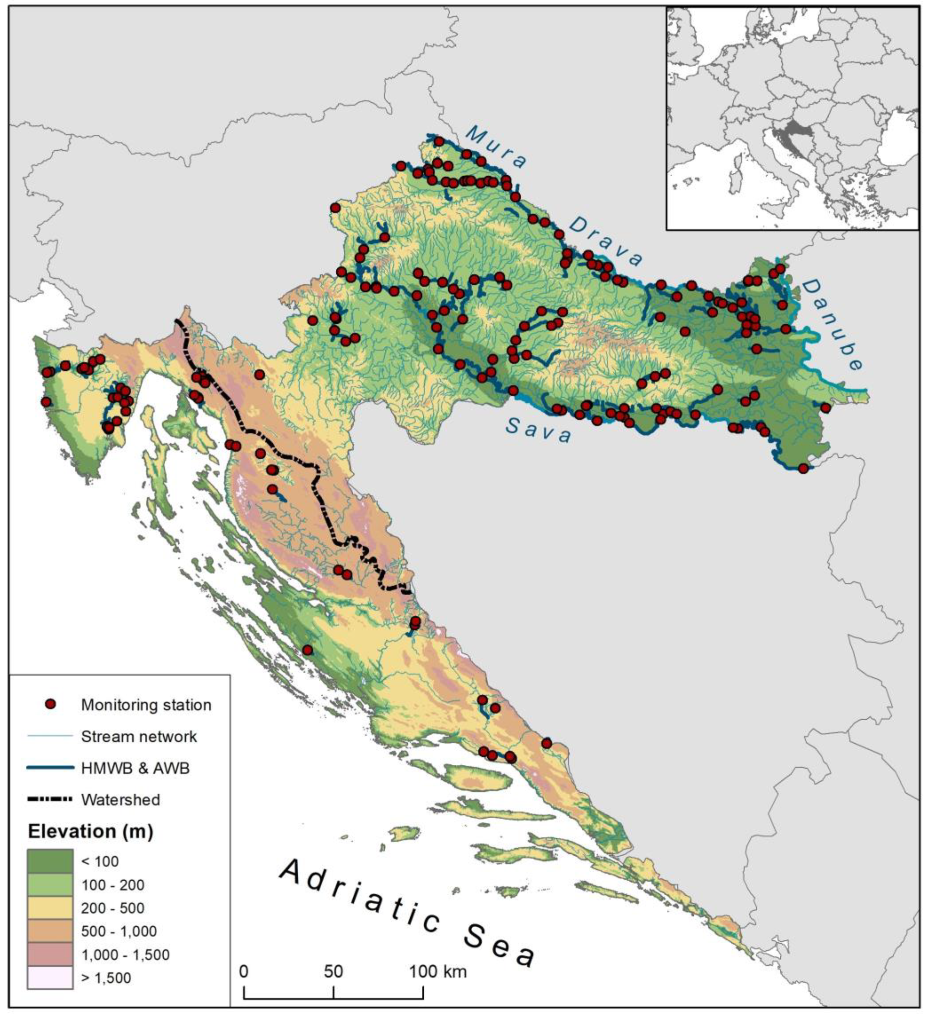
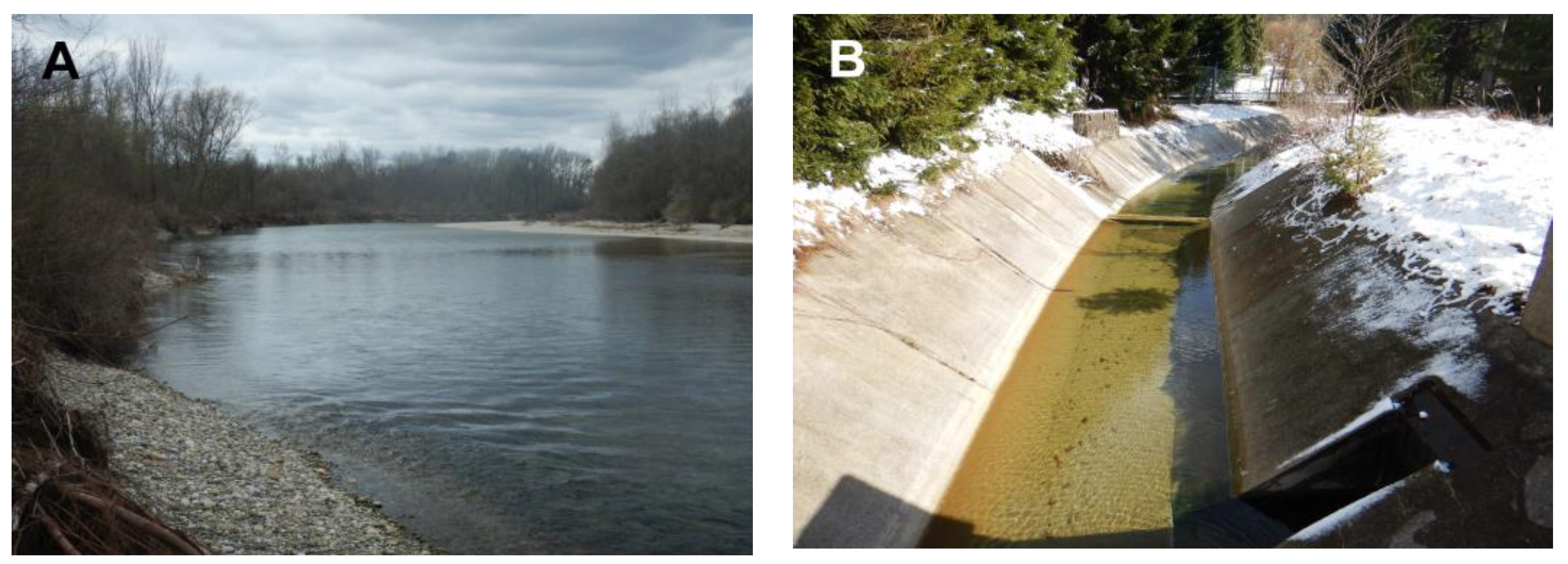
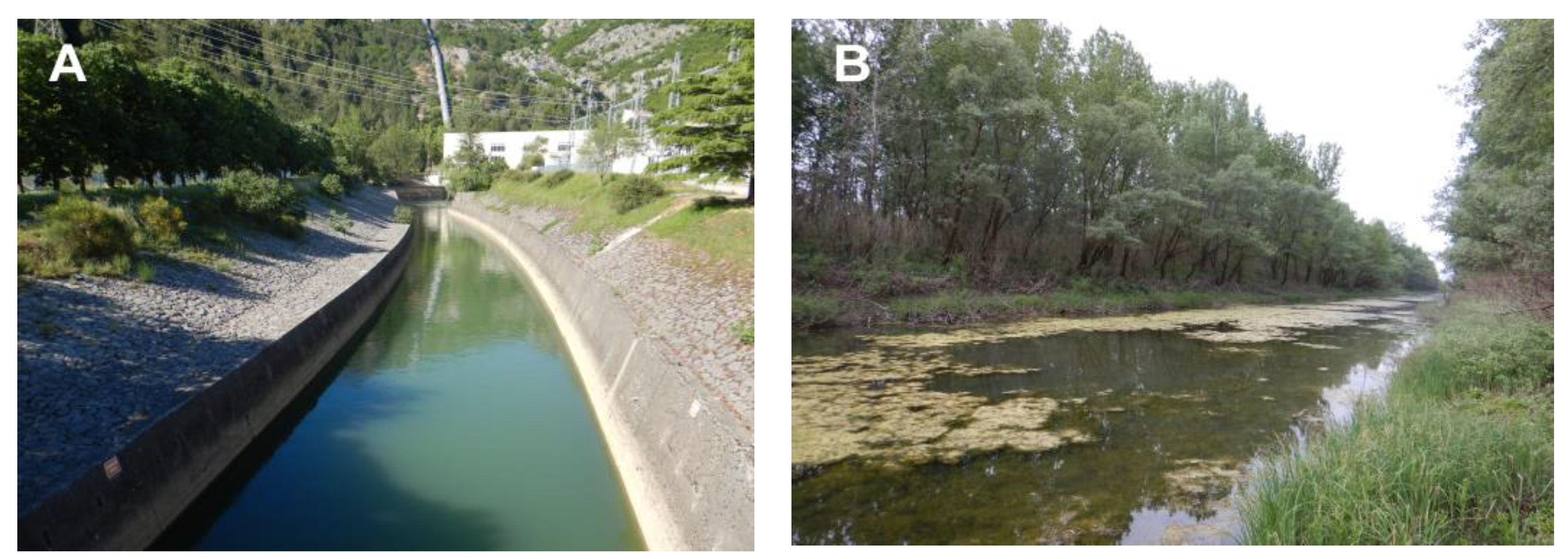
2. Study Area
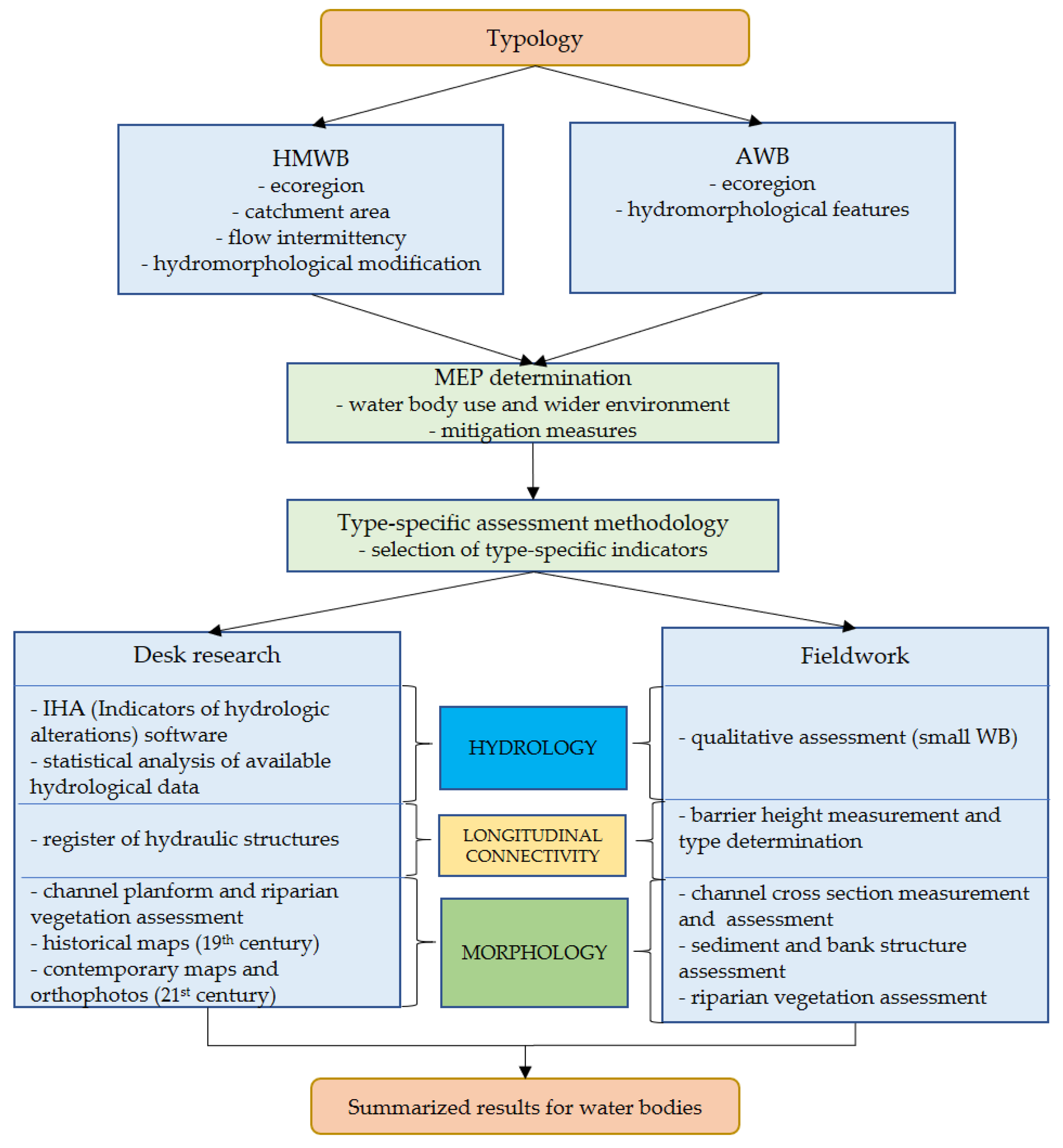
3. Materials and Methods
- To ensure ecological continuum and ecological flow of watercourses according to CIS guidance documents.
- To ensure a minimum amount of water in melioration lowland canals.
- To ensure the necessary flow and energy drop to produce electricity at existing facilities.
- To ensure the required volume in reservoirs and water intake facilities for the supply of drinking water, operation of existing hydropower plants and irrigation.
- To allow moderate seasonal changes in the runoff regime associated with the above functions.
- To allow minor changes in the channel planform and cross-section.
- To ensure optimal drainage of agricultural land while respecting the minimum environmentally friendly depth and/or flow of water in the channel throughout the year and leaving woody riparian vegetation (preferably on the south or west bank of the stream) in a way that creates a high percentage of shading and reduces the input of organic material and fine sediment. The other shore can be covered with herbaceous vegetation and individual trees that allow access for machines to periodically maintain the channel (e.g., prevention of blockages).
- To ensure a narrow line of flood defense in dense urban areas.
- To allow moving of a small amount of sediment inside the channel for flood protection in compliance with the environmental protection acts and other related laws and directives.
- To reduce the risk of floods on natural watercourses while respecting the minimum environmentally friendly depth and/or water flow in the channel throughout the year and leaving woody riparian vegetation in a way that creates a high percentage of shading and reduces the input of organic material and fine sediment.
- The relationship between surface- and groundwater must not be disturbed in order to preserve ecosystems dependent on groundwater and in compliance with the provisions of the environmental protection acts and other related laws and directives.
- To ensure the minimum depth of water for inland navigation and mooring of ships on the legally defined waterway and the related regularly prescribed maintenance of the waterway.
4. Results
5. Discussion
5.1. Challenges in Assessing Hydromorphological Conditions of HMWBs and AWBs
5.2. Selection of Indicators for the Assessment of Hydromorphological Conditions and MEP
5.3. Impact of Hydromorphological Modifications on Biological Quality Elements
6. Conclusions
Author Contributions
Funding
Institutional Review Board Statement
Informed Consent Statement
Data Availability Statement
Acknowledgments
Conflicts of Interest
References
- Downs, P.W.; Piégay, H. Catchment-scale cumulative impact of human activities on river channels in the late Anthropocene: Implications, limitations, prospect. Geomorphology 2019, 338, 88–104. [Google Scholar] [CrossRef]
- Surian, N.; Rinaldi, M. Morphological response to river engineering and management in alluvial channels in Italy. Geomorphology 2003, 50, 307–326. [Google Scholar] [CrossRef]
- Gregory, K.J. The human role in changing river channels. Geomorphology 2006, 79, 172–191. [Google Scholar] [CrossRef]
- Graf, W.; Leitner, P.; Hanetseder, I.; Ittner, L.D.; Dossi, F.; Hauer, C. Ecological degradation of a meandering river by local channelization effects: A case study in an Austrian lowland river. Hydrobiologia 2016, 772, 145–160. [Google Scholar] [CrossRef]
- Hasenmueller, E.A.; Robinson, H.K. Hyporheic zone flow disruption from channel linings: Implications for the hydrology and geochemistry of an urban stream, St. Louis, Missouri, USA. J. Earth Sci. 2016, 27, 98–109. [Google Scholar] [CrossRef]
- Kondolf, G.M. Hungry water: Effects of dams and gravel mining on river channels. Environ. Manag. 1997, 21, 533–551. [Google Scholar] [CrossRef]
- Neal, E.G. Channel incision and water-table decline along a recently formed proglacial stream, Mendenhall Valley, southeastern Alaska. In Studies by the U.S. Geological Survey in Alaska; U.S. Geological Survey Professional Paper 1760-E; Haeussler, P.J., Galloway, J.P., Eds.; U.S. Geological Survey: Reston, VA, USA, 2009. [Google Scholar]
- European Commission. Directive 2000/60/EC of the European Parliament and of the Council: Establishing a Framework for Community Action in the Field of Water Policy; European Commission: Kirchberg, Luxembourg, 2000. [Google Scholar]
- Elosegi, A.; Díez, J.; Mutz, M. Effects of hydromorphological integrity on biodiversity and functioning of river ecosystems. Hydrobiologia 2010, 657, 199–215. [Google Scholar] [CrossRef]
- Elosegi, A.; Sabater, S. Effects of hydromorphological impacts on river ecosystem functioning: A review and suggestions for assessing ecological impacts. Hydrobiologia 2013, 712, 129–143. [Google Scholar] [CrossRef]
- Kampa, E.; Bussettini, M. River Hydromorphological Assessment and Monitoring Methodologies—Final Report, Part 1—Summary of European Country Questionnaires; ECOSTAT: Brussels, Belgium, 2018; p. 126. Available online: https://www.ecologic.eu/sites/default/files/publication/2018/2626–01_hymo_assessment_rivers.pdf (accessed on 20 March 2022).
- CIS. Common Implementation Strategy for the Water Framework Directive, Guidance Document No. 3: Analysis of Pressures and Impacts; Produced by Working Group 2.1—IMPRESS; Office for Official Publications of the European Communities: Luxembourg, 2003; p. 149. [Google Scholar]
- CIS. Common Implementation Strategy for the Water Framework Directive, Guidance Document No. 4: Identification and Designation of Heavily Modified and Artificial Water Bodies; Produced by Working Group 2.2—HMWB; Office for Official Publications of the European Communities: Luxembourg, 2003; p. 108. [Google Scholar]
- CIS. Common Implementation Strategy for the Water Framework Directive, Guidance Document No. 37: Steps for Defining and Assessing Ecological Potential for Improving Comparability of Heavily Modified Water Bodies; Produced by Working Group ECOSTAT; Office for Official Publications of the European Communities: Luxembourg, 2019; p. 134. [Google Scholar]
- Halleraker, J.H.; van de Bund, W.; Bussettini, M.; Gosling, R.; Döbbelt-Grüne, S.; Hensman, J.; Kling, J.; Koller-Kreimel, V.; Pollard, P. Working Group ECOSTAT Report on Common Understanding of Using Mitigation Measures for Reaching Good Ecological Potential for Heavily Modified Water Bodies. Part 1: Impacted by Water Storage; EUR 28413 EN; Publications Office of the European Union: Luxembourg, 2016. [Google Scholar] [CrossRef]
- Belletti, B.; Rinaldi, M.; Buijse, A.D.; Gurnell, A.M.; Mosselman, E. A review of assessment methods for river hydromorphology. Environ. Earth Sci. 2015, 73, 2079–2100. [Google Scholar] [CrossRef]
- Hajdukiewicz, H.; Wyżga, B.; Zawiejska, J.; Amirowicz, A.; Oglęcki, P.; Radecki-Pawlik, A. Assessment of river hydromorphological quality for restoration purposes: An example of the application of RHQ method to a Polish Carpathian river. Acta Geophys. 2017, 65, 423–440. [Google Scholar] [CrossRef] [Green Version]
- Belletti, B.; Rinaldi, M.; Bussettini, M.; Comiti, F.; Gurnell, A.M.; Mao, L.; Nardi, L.; Vezza, P. Characterising physical habitats and fluvial hydromorphology: A new system for the survey and classification of river geomorphic units. Geomorphology 2017, 283, 143–157. [Google Scholar] [CrossRef]
- Rinaldi, M.; Belletti, B.; Bussettini, M.; Comiti, F.; Golfieri, B.; Lastoria, B.; Marchese, E.; Nardi, L.; Surian, N. New tools for the hydromorphological assessment and monitoring of European streams. J. Environ. Manag. 2017, 202, 363–378. [Google Scholar] [CrossRef] [PubMed]
- Stefanidis, K.; Latsiou, A.; Kouvarda, T.; Lampou, A.; Kalaitzakis, N.; Gritzalis, K.; Dimitriou, E. Disentangling the main components of hydromorphological modifications at reach scale in rivers of Greece. Hydrology 2020, 7, 22. [Google Scholar] [CrossRef] [Green Version]
- CEN. Water Quality—Guidance Standard on Determining the Degree of Modification of River Hydromorphology; EN 15843; CEN: Brussels, Belgium, 2010; p. 24. [Google Scholar]
- Latinopoulos, D.; Ntislidou, C.; Kagalou, I. A multi-approach lake habitat survey method for impact assessment in two heavily modified lakes: A case of two Northern Greek lakes. Environ. Monit. Assess. 2018, 190, 658. [Google Scholar] [CrossRef]
- Garbowski, T.; Brysiewicz, A.; Nosek, J.; Bar-Michalczyk, D.; Czerniejewski, P. An Analysis of Hydromorphological Index for Rivers (HIR) Model Components, Based on a Hydromorphological Assessment of Watercourses in the Central European Plain. Environ. Manag. 2023, 1–19. [Google Scholar] [CrossRef]
- Mihaljević, Z.; Pozojević, I.; Vučković, N. Klasifikacijski Sustav Ekološkog Potencijala za Umjetna i Znatno Promijenjena Tijela Površinskih Voda—III. Dio: Tekućice Panonske Ekoregije; Prirodoslovno-Matematički Fakultet, Sveučilište u Zagrebu: Zagreb, Croatia, 2021; p. 204. [Google Scholar]
- Mihaljević, Z.; Pozojević, I.; Vučković, N. Klasifikacijski Sustav Ekološkog Potencijala za Umjetna i Znatno Promijenjena Tijela Površinskih Voda—IV. Dio: Tekućice Dinaridske Ekoregije; Prirodoslovno-Matematički Fakultet, Sveučilište u Zagrebu: Zagreb, Croatia, 2021; p. 216. [Google Scholar]
- Čanjevac, I.; Orešić, D. Surface water resources and their management in Croatia. In Water Resources Management in Balkan Countries; Negm, A., Romanescu, G., Zelenáková, M., Eds.; Springer International Publishing: Berlin/Heidelberg, Germany, 2020; pp. 159–174. [Google Scholar]
- Ministère de l’Écologie, de l’Énergie; du Développement Durable et de la Mer. Arrêté du 25 janvier 2010 relatif aux méthodes et critères d’evaluation de l’état écologique, de l’état chemique et du potentiel écologique des eaux de surface. J. Off. Repub. Française 2010, 46. Available online: https://www.legifrance.gouv.fr/eli/arrete/2010/1/25/DEVO1001032A/jo/texte (accessed on 20 March 2022).
- Plantak, M.; Čanjevac, I.; Vidaković, I. Morphological state of rivers in the Ilova River catchment. Hrvat. Geogr. Glas. 2016, 78, 5–24. [Google Scholar] [CrossRef] [Green Version]
- Zaharia, L.; Ioana-Toroimac, G.; Moroşanu, G.A.; Gălie, A.C.; Moldoveanu, M.; Čanjevac, I.; Belleudy, P.; Plantak, M.; Buzjak, N.; Bočić, N.; et al. Review of national methodologies for rivers’ hydromorphological assessment: A comparative approach in France, Romania, and Croatia. J. Environ. Manag. 2018, 217, 735–746. [Google Scholar] [CrossRef]
- Greimel, F.; Schülting, L.; Graf, W.; Bondar-Kunze, E.; Auer, S.; Zeiringer, B.; Hauer, C. Hydropeaking Impacts and Mitigation. In Riverine Ecosystem Management; Schmutz, S., Sendzimir, J., Eds.; Aquatic Ecology Series; Springer: Cham, Switzerland, 2018; Volume 8, pp. 91–110. [Google Scholar]
- Čanjevac, I.; Pavlek, K.; Orešić, D. River lengths in Croatia determined from a topographic map at a scale of 1:25,000. Hrvat. Geogr. Glas. 2022, 84, 5–30. [Google Scholar] [CrossRef]
- Arcanum Maps. Available online: https://maps.arcanum.com/en/ (accessed on 15 May 2020).
- Rinaldi, M.; Baena-Escudero, R.; Nardi, L.; Guerrero-Amador, I.C.; García-Martínez, B. An assessment of the hydromorphological conditions of the middle and lower Guadalquivir River (southern Spain). Phys. Geogr. 2020, 41, 254–271. [Google Scholar] [CrossRef]
- Gündüz, O.; Şimşek, C. Assessment of river alteration using a new hydromorphological index. Environ. Monit. Assess. 2021, 193, 226. [Google Scholar] [CrossRef]
- Tomczyk, P.; Willems, P.; Wiatkowski, M. Comparative analysis of changes in hydromorphological conditions upstream and downstream hydropower plants on selected rivers in Poland and Belgium. J. Clean. Prod. 2021, 328, 129524. [Google Scholar] [CrossRef]
- Dou, P.; Wang, X.; Lan, Y.; Cui, B.; Bai, J.; Xie, T. Benthic Macroinvertebrate Diversity as Affected by the Construction of Inland Waterways along Montane Stretches of Two Rivers in China. Water 2022, 14, 1080. [Google Scholar] [CrossRef]
- Stefanidis, K.; Dimitrellos, G.; Sarika, M.; Tsoukalas, D.; Papastergiadou, E. Ecological Quality Assessment of Greek Lowland Rivers with Aquatic Macrophytes in Compliance with the EU Water Framework Directive. Water 2022, 14, 2771. [Google Scholar] [CrossRef]
- Moldoveanu, M.; Stănescu, S.V.; Gălie, A.C. Post-Construction, Hydromorphological Cumulative Impact Assessment: An Approach at the Waterbody Level Integrating Different Spatial Scales. Water 2023, 15, 382. [Google Scholar] [CrossRef]
- Erba, S.; Terranova, L.; Cazzola, M.; Cason, M.; Buffagni, A. Defining Maximum Ecological Potential for heavily modified lowland streams of Northern Italy. Sci. Total Environ. 2019, 684, 196–206. [Google Scholar] [CrossRef] [PubMed]
- El Hourani, M.; Härtling, J.; Broll, G. Hydromorphological Assessment as a Tool for River Basin Management: Problems with the German Field Survey Method at the Transition of Two Ecoregions. Hydrology 2022, 9, 120. [Google Scholar] [CrossRef]
- Živaković-Kerže, Z. Od močvare do oranica: Osvrt na povijest preobrazbe okoliša osječkog kraja hidromelioracijom porječja Vuke i isušenjem močvare Palače. Osječki Zb. 2004, 27, 83–89. [Google Scholar]
- Lewandowski, P. Polish Investigations on River Hydromorphology. Pol. J. Environ. Stud. 2012, 21, 957–965. [Google Scholar]
- Grabowski, R.C.; Surian, N.; Gurnell, A.M. Characterizing geomorphological change to support sustainable river restoration and management. Wiley Interdiscip. Rev. Water 2014, 1, 483–512. [Google Scholar] [CrossRef]
- Bonacci, O.; Roje-Bonacci, T. The influence of hydroelectrical development on the flow regime of the karstic river Cetina. Hydrol. Process. 2003, 17, 1–15. [Google Scholar] [CrossRef]
- Pavlek, K.; Faivre, S. Geomorphological changes of the Cetina River channels since the end of the nineteenth century, natural vs anthropogenic impacts (the Dinarides, Croatia). Environ. Earth Sci. 2020, 79, 482. [Google Scholar] [CrossRef]
- Scorpio, V.; Aucelli, P.P.; Giano, S.I.; Pisano, L.; Robustelli, G.; Rosskopf, C.M.; Schiattarella, M. River channel adjustments in Southern Italy over the past 150 years and implications for channel recovery. Geomorphology 2015, 251, 77–90. [Google Scholar] [CrossRef]
- Martínez-Fernández, V.; González del Tánago, M.; Maroto, J.; García de Jalón, D. Fluvial corridor changes over time in regulated and non-regulated rivers (Upper Esla River, NW Spain). River Res. Appl. 2017, 33, 214–223. [Google Scholar] [CrossRef]
- Liro, M. Gravel-bed channel changes upstream of a reservoir: The case of the Dunajec River upstream of the Czorsztyn Reservoir, southern Poland. Geomorphology 2015, 228, 694–702. [Google Scholar] [CrossRef]
- Liro, M.; Ruiz-Villanueva, V.; Mikuś, P.; Wyżga, B.; Castellet, E.B. Changes in the hydrodynamics of a mountain river induced by dam reservoir backwater. Sci. Total Environ. 2020, 744, 140555. [Google Scholar] [CrossRef]
- Baena-Escudero, R.; Guerrero-Amador, I.C.; Rinaldi, M.; González-Sayago, A. Hydrological and geomorphic effects upstream of the Cantillana Dam along the Guadalquivir River (southern Spain). Geomorphology 2021, 388, 107786. [Google Scholar] [CrossRef]
- Borja, Á.; Chust, G.; del Campo, A.; González, M.; Hernández, C. Setting the maximum ecological potential of benthic communities, to assess ecological status, in heavily morphologically-modified estuarine water bodies. Mar. Pollut. Bull. 2013, 71, 199–208. [Google Scholar] [CrossRef]
- Ondiviela, B.; Gómez, A.G.; Puente, A.; Juanes, J.A. A pragmatic approach to define the ecological potential of water bodies heavily modified by the presence of ports. Environ. Sci. Policy 2013, 33, 320–331. [Google Scholar] [CrossRef]
- Vartia, K.; Beekman, J.; Alves, M.; van de Bund, W.; Bussettini, M.; Döbbelt-Grüne, S.; Halleraker, J.H.; Karottki, I.; Kling, J.; Wallentin, J. WG ECOSTAT Report on Common Understanding of Using Mitigation Measures for Reaching Good Ecological Potential for Heavily Modified Water Bodies; EUR 29132 EN; (JRC110959); Publications Office of the European Union: Luxembourg, 2018; ISBN 978-92-79-80305-5. [Google Scholar] [CrossRef]
- Šumanović, M.; Pozojević, I.; Mihaljević, Z.; Vučković, N.; Dorić, V.; Miliša, M. Invertebrate functional responses to hydro morpho-logical degradation in Mediterranean Croatian rivers. Fundam. Appl. Limnol. 2021, 194, 259–270. [Google Scholar] [CrossRef]
- Kail, J.; Wolter, C. Pressures at larger spatial scales strongly influence the ecological status of heavily modified river water bodies in Germany. Sci. Total Environ. 2013, 454, 40–50. [Google Scholar] [CrossRef]
- Eberstaller-Fleischanderl, D.; Eberstaller, J. Flussbau und Ökologie, Flussbauliche Maßnahmen zur Erreichung des Gewässerökologischen Zielzustandes; BMLFUW und Amt der NÖ Landesregierung: St. Pölten, Austria, 2014; p. 360. [Google Scholar]
- Xiang, H.; Zhang, Y.; Richardson, J.S. Importance of riparian zone: Effects of resource availability at land-water interface. Riparian Ecol. Conserv. 2017, 3, 1–17. [Google Scholar] [CrossRef]
- Buffagni, A.; Tenchini, R.; Cazzola, M.; Erba, S.; Balestrini, R.; Belfiore, C.; Pagnotta, R. Detecting the impact of bank and channel modification on invertebrate communities in Mediterranean temporary streams (Sardinia, SW Italy). Sci. Total Environ. 2016, 565, 1138–1150. [Google Scholar] [CrossRef] [PubMed]
- Buffagni, A.; Barca, E.; Erba, S.; Balestrini, R. In-stream microhabitat mosaic depicts the success of mitigation measures and controls the Ecological Potential of benthic communities in heavily modified rivers. Sci. Total Environ. 2019, 673, 489–501. [Google Scholar] [CrossRef] [PubMed]
- González del Tánago, M.; Martínez-Fernández, V.; Aguiar, F.C.; Bertoldi, W.; Dufour, S.; de Jalón, D.G.; Garófano-Gómez, V.; Mandzukovski, D.; Rodríguez-González, P.M. Improving river hydromorphological assessment through better integration of riparian vegetation: Scientific evidence and guidelines. J. Environ. Manag. 2021, 292, 112730. [Google Scholar] [CrossRef] [PubMed]


| Pannonian Ecoregion | Dinaric and Adriatic Ecoregion | Description of the River Type |
|---|---|---|
| HR-K_1A | HR-K_7A | Small, heavily modified rivers with modified morphology (catchment area 5–100 km2) |
| HR-K_1B | HR-K_7B | Small, heavily modified rivers with modified morphology and longitudinal connectivity (catchment area 5–100 km2) |
| HR-K_2A | HR-K_8A | Medium-sized, heavily modified rivers with modified morphology (catchment area 100–1000 km2) |
| HR-K_2B | HR-K_8B | Medium-sized, heavily modified rivers with modified morphology and longitudinal connectivity (catchment area 100–1000 km2) |
| HR-K_3A | HR-K_9A | Large, heavily modified rivers with modified morphology (catchment area 1000–10,000 km2) |
| HR-K_3B | HR-K_9B | Large, heavily modified rivers with modified morphology and longitudinal connectivity (catchment area 1000–10,000 km2) |
| HR-K_4 | Very large, heavily modified rivers with modified morphology (catchment area larger than 10,000 km2) | |
| HR-K_5 | HR-K_12 | Heavily modified rivers with large changes in discharge |
| HR-K_6A | HR-K_13A | Artificial streams with large daily changes in flow |
| HR-K_6B | Artificial streams with disturbed groundwater–surface water interactions | |
| HR-K_6C | HR-K_13B | Artificial streams with large seasonal flow changes |
| HR-K_10 and HR-K_11 | Heavily modified ephemeral streams with changed morphology |
| Indicator Description | 1A, 1B, 7A, 7B | 2A, 2B, 8A, 8B | 3A, 3B, 9A, 9B | 4 | 5, 12 | 10, 11 | 6A, 13A | 6B, 6C, 13B | |
|---|---|---|---|---|---|---|---|---|---|
| Hydrology | Changes in mean seasonal discharge (or water level) | ✔ | ✔ | ✔ | ✔ | ✘ | ✔ | ✘ | ✘ |
| Daily changes in water level during average water levels | ✔ | ✔ | ✔ | ✔ | ✔ | ✘ | ✔ | ✘ | |
| Daily changes in discharge | ✘ | ✘ | ✘ | ✘ | ✔ | ✘ | ✘ | ✘ | |
| Days without flow in the channel | ✔ | ✔ | ✔ | ✘ | ✘ | ✘ | ✔ | ✔ | |
| Longitudinal connectivity considering biota migration (fish, etc.) | ✔ | ✔ | ✔ | ✔ | ✔ | ✔ | ✔ | ✔ | |
| Morphology | Changes in the channel planform | ✔ | ✔ | ✔ | ✔ | ✔ | ✔ | ✘ | ✘ |
| Changes in the channel cross-section | ✔ | ✔ | ✔ | ✔ | ✔ | ✔ | ✘ | ✘ | |
| The amount of artificial hard materials below the water level | ✔ | ✔ | ✔ | ✔ | ✔ | ✔ | ✔ | ✔ | |
| Artificiality of the bed sediment | ✔ | ✔ | ✔ | ✔ | ✔ | ✔ | ✘ | ✘ | |
| Bank structure | ✔ | ✔ | ✔ | ✔ | ✔ | ✔ | ✘ | ✔ | |
| Bank slope | ✔ | ✔ | ✔ | ✔ | ✔ | ✔ | ✘ | ✔ | |
| Length of the riparian corridor | ✔ | ✔ | ✔ | ✔ | ✔ | ✔ | ✔ | ✔ | |
| Lateral connectivity with the floodplain | ✘ | ✘ | ✘ | ✔ | ✔ * | ✘ | ✘ | ✘ | |
| Lateral channel movement | ✔ | ✔ | ✔ | ✔ | ✔ | ✔ | ✘ | ✘ | |
| Indicator Description | Average Score | Median Score |
|---|---|---|
| Changes in mean seasonal discharge (or water level) | 2.48 | 3 |
| Daily changes in water level during average water levels | 2.24 | 2 |
| Daily changes in discharge | 2.33 | 2 |
| Days without flow in the channel | 2.34 | 2 |
| Longitudinal connectivity considering biota migration (fish, etc.) | 2.47 | 1 |
| Changes in the channel planform | 2.75 | 2 |
| Changes in the channel cross-section | 3.45 | 4 |
| The amount of artificial hard materials below the water level | 1.14 | 1 |
| Artificiality of the bed sediment | 2.41 | 3 |
| Bank structure | 2.46 | 3 |
| Bank slope | 2.13 | 2 |
| Length of the riparian corridor | 3.14 | 3 |
| Lateral connectivity with the floodplain | 2.72 | 3 |
| Lateral movement | 3.42 | 4 |
| WB Type | Hydrology | Longitudinal Connectivity | Morphology |
|---|---|---|---|
| HR-K_1A | 1.83 | 1.00 | 3.21 |
| HR-K_1B | 2.12 | 4.43 | 2.94 |
| HR-K_2A | 2.23 | 1.00 | 2.95 |
| HR-K_2B | 2.15 | 4.45 | 3.34 |
| HR-K_3A | 2.13 | 1.00 | 3.38 |
| HR-K_3B | 2.00 | 5.00 | 2.25 |
| HR-K_4 | 2.05 | 1.00 | 1.53 |
| HR-K_5 | 1.56 | 1.50 | 1.90 |
| HR-K_6A | 2.71 | 5.00 | 3.57 |
| HR-K_6B | 2.60 | 1.40 | 2.75 |
| HR-K_6C | 3.41 | 1.76 | 2.55 |
| HR-K_7B | 2.76 | 3.86 | 2.98 |
| HR-K_8A | 1.67 | 1.00 | 3.69 |
| HR-K_8B | 1.78 | 5.00 | 2.04 |
| HR-K_10 | 2.00 | 4.00 | 2.58 |
| HR-K_12 | 3.50 | 3.00 | 2.16 |
| HR-K_13A | 3.00 | 5.00 | 4.00 |
| HR-K_13B | 2.78 | 2.11 | 2.67 |
| Average | 2.49 | 2.47 | 2.62 |
Disclaimer/Publisher’s Note: The statements, opinions and data contained in all publications are solely those of the individual author(s) and contributor(s) and not of MDPI and/or the editor(s). MDPI and/or the editor(s) disclaim responsibility for any injury to people or property resulting from any ideas, methods, instructions or products referred to in the content. |
© 2023 by the authors. Licensee MDPI, Basel, Switzerland. This article is an open access article distributed under the terms and conditions of the Creative Commons Attribution (CC BY) license (https://creativecommons.org/licenses/by/4.0/).
Share and Cite
Pavlek, K.; Plantak, M.; Martinić, I.; Vinković, K.; Vučković, I.; Čanjevac, I. Methodological Framework for Assessing Hydromorphological Conditions of Heavily Modified and Artificial River Water Bodies in Croatia. Water 2023, 15, 1113. https://doi.org/10.3390/w15061113
Pavlek K, Plantak M, Martinić I, Vinković K, Vučković I, Čanjevac I. Methodological Framework for Assessing Hydromorphological Conditions of Heavily Modified and Artificial River Water Bodies in Croatia. Water. 2023; 15(6):1113. https://doi.org/10.3390/w15061113
Chicago/Turabian StylePavlek, Katarina, Mladen Plantak, Ivan Martinić, Karlo Vinković, Ivan Vučković, and Ivan Čanjevac. 2023. "Methodological Framework for Assessing Hydromorphological Conditions of Heavily Modified and Artificial River Water Bodies in Croatia" Water 15, no. 6: 1113. https://doi.org/10.3390/w15061113