Article

Using Artificial Intelligence to Identify Suitable Artificial Groundwater Recharge Areas for the Iranshahr Basin

1
Copernicus Institute of Sustainable Development, Utrecht University, 3584 CB Utrecht, The Netherlands
2
Department of Geology, Shahid Bahonar University of Kerman, Kerman 76169-13439, Iran
3
Department of Earth Sciences, Utrecht University, 3584 CB Utrecht, The Netherlands
4
Department of Economics, Faculty of Management and Economics, Shahid Bahonar University of Kerman, Kerman 76169-13439, Iran
*
Author to whom correspondence should be addressed.
Water 2023, 15(6), 1182; https://doi.org/10.3390/w15061182
Submission received: 5 February 2023 / Revised: 6 March 2023 / Accepted: 15 March 2023 / Published: 18 March 2023
(This article belongs to the Section Hydrology)

Abstract

:
A water supply is vital for preserving usual human living standards, industrial development, and agricultural growth. Scarce water supplies and unplanned urbanization are the primary impediments to results in dry environments. Locating suitable sites for artificial groundwater recharge (AGR) could be a strategic priority for countries to recharge groundwater. Recent advances in machine learning (ML) techniques provide valuable tools for producing an AGR site suitability map (AGRSSM). This research developed an ML algorithm to identify the most appropriate location for AGR in Iranshahr, one of the major districts in the East of Iran characterized by severe drought and excessive groundwater consumption. The area’s undue reliance on groundwater resources has resulted in aquifer depletion and socioeconomic problems. Nine digitized and georeferenced data layers have been considered for preparing the AGRSSM, including precipitation, slope, geology, unsaturated zone thickness, land use, distance from the main rivers, precipitation, water quality, and transmissivity of soil. The developed AGRSSM was trained and validated using 1000 randomly selected points across the study area with an accuracy of 97%. By comparing the results of the proposed sites with those of other methods, it was discovered that the artificial intelligence method could accurately determine artificial recharge sites. In summary, this study uses a novel approach to identify optimal AGR sites using machine learning algorithms. Our findings have practical implications for policymakers and water resource managers looking to address the problem of groundwater depletion in Iranshahr and other regions facing similar challenges. Future research in this area could explore the applicability of our approach to other regions and examine the potential economic benefits of using AGR to recharge groundwater.

1. Introduction

Groundwater is a critical water source for agriculture in Iran’s arid/semiarid regions, particularly in the central part [1,2]. Despite its importance, the relevance of groundwater environmental balance has received insufficient attention, given the rising population and demand for additional food and irrigated farmed lands [3,4]. Groundwater is one of the most critical water sources for agriculture in Iran’s arid/semiarid regions, particularly in the central part, which consumes approximately 92% of the country’s water, 52% of which is supplied by groundwater resources [5]. A recent study by Dalin et al. [6], highlights that Iran is one of the countries with the highest levels of embedded groundwater depletion, with a depletion of around 100 Bm3 in the last two decades. This depletion has adversely affected the lives of the people living in the region. As a result, there is an urgent need to identify and evaluate essential criteria for restoring aquifers, particularly by establishing artificial recharge zones. The most common techniques used for aquifer rehabilitation include the infiltration of groundwater wells or land surfaces. However, since groundwater is a complex spatiotemporal phenomenon, utilizing surface infiltration systems to replenish aquifers requires much research and investigation to accurately identify and target suitable locations for artificial recharge zones.
Therefore, many different effective parameters for artificial recharge zones were studied. These included depth below ground, permeability, transmissivity, distance to the water source and well, geology, unsaturated aquifer thickness, land use, water quality, and land slope. Several strategies exist for restoring groundwater supplies. However, traditional approaches may make it impossible or difficult to discover suitable places for artificial recharge [7,8]. Geographic information systems (GIS), remote sensing (RS), mathematical models, heuristic algorithms, and a variety of criterion decision-making methods (such as the analytical hierarchy process (AHP), the fuzzy analytical hierarchy process (FAHP), and the technique for order preference by similarity to ideal solution (TOPSIS) have all been applied to the problem of artificial groundwater recharge zoning. This study aimed to locate suitable sites for artificial recharge in the arid region of the Iranshahr Plain utilizing analysis supported by state-of-the-art machine learning integration and verification using a fuzzy analytic hierarchy process to improve aquifer rehabilitation and restoration.
Machine learning algorithms (MLAs) have recently evolved in precise forecast modeling, identifying detailed patterns, particularly irregular data, and developing extremely accurate forecast models [9,10]. The MLAs are not confined to the commonly used traditional approaches that rely on uncompromising statistical postulations and linear or additive methodologies. They have a more substantial mastery of resolving complicated interactions [9,11]. Machine learning (ML) is frequently referred to as artificial intelligence (AI) due to its learning and decision-making capabilities, although it is a subset of AI. ML algorithms develop a mathematical model utilizing sample and training data to make decisions without being specifically programmed to make those decisions [12]. Artificial neural networks (ANN) are widely regarded as one of the most significant developments in ML, with applications in a wide variety of fields that resemble how the human brain works, bringing us closer to realizing the goal of machines that can think and learn as humans do by involving many neurons communicating to transmit messages throughout the body [13].
Based on a collection of linked nodes known as artificial neurons, ANN improves the system’s expressive capabilities. The ANN approach has lately been applied to handle groundwater-related issues [14]. Mohanty et al. [15] used an ANN model to forecast groundwater levels in various bores using expert knowledge and statistical analysis. The ANN was used to predict the groundwater level in a Singapore swamp forest based on rainfall and the levels of nearby reservoirs [16]. Pasandi et al. [17] used an ANN to estimate the water table depth in Shibkooh, Iran, utilizing auxiliary data such as aquifer bed elevation and thickness.
Deep learning is helpful in studies of groundwater management. Using rainfall and pumping discharge data, Kong-A-Siou et al. [18] suggested a recurrent multilayer perceptron for predicting the water table level. Jiang et al. [19] used a super-resolution convolutional neural network to categorize paleo-valleys essential in groundwater exploration. Recent developments in processing speed and data storage have enabled numerically intensive analyses to be performed at large scales and at a low cost. Machine learning and deep learning models are widely employed in various domains, including forest cover projection, climate forecasting, and flood and typhoon forecasting [20,21,22,23]. This study utilizes state-of-the-art machine learning integration and verification using a fuzzy analytic hierarchy process to improve aquifer rehabilitation and restoration. Furthermore, the study highlights the potential of machine learning and deep learning models in predicting groundwater recharge dynamics, a relatively new field of study. Research such as this uses conventional regression methods such as linear regression, neural networks, and deep learning to boost the accuracy of groundwater recharge dynamics predictions.

2. Materials and Methods

2.1. Study Area

The Iranshahr plain, with an area of 41,730 km2, is located in the province of Sistan and Baluchistan in southeast Iran. This region is in an arid tropical zone in Iran, with an annual precipitation of 99.09 mm. Surface water supplies have become insufficient due to unplanned urbanization, population growth, changing consumption patterns, limited water resources, and inadequate water supply and distribution regulations, allowing for inappropriate groundwater use in many regions, including Iranshahr [24].

2.2. Input Data

Nine digitized and georeferenced data layers were used as input data in the ArcGIS Pro 2.9 environment, including geology, unsaturated zone thickness, land use, distance from major rivers, precipitation, water quality, soil transmissivity, and slope maps [25,26], all of which are discussed briefly below. The preparation of this input data is the most time-consuming part of the study, and the study’s findings are highly dependent on the precision of the input data.

2.2.1. Geology

One of the essential characteristics of hydrogeological investigations is the permeability of geological formations [27]. Therefore, quaternary deposits suitable for this property are typically the site of artificial aquifer restoration. The Iranshahr Plain was divided into quaternary units (QAl: sediments of the main rivers, buried channels, and flood plains; Qm: uniform floodplains and lake sediments; QS: sand dune; Qft2: Young alluvial fan; Qft1: old alluvial fan; and OC: coarse-grained conglomerate) and digitized for future use.

2.2.2. Soil/Surface Permeability

The soil zone also governs the percolation rate and hydraulic conductivity [28,29] before the water reaches the subsurface aquifer system. Factors such as climate, vegetation, and human intervention impact the soil’s primary chemical and physical properties. There are eight main soil types in the Iranshahr basin, with the highest permeability ratio found in alluvial sediment, debris, and sandy dunes and the lowest in mass rocks (i.e., limestone, sandstone, siltstone, igneous, and metamorphic). Machine learning was used to analyze the water infiltration rate into the soil in the study area based on the obtained and normalized values of the relative surface permeability.

2.2.3. Slope

Areas with steep slopes have a low groundwater level since most rainfall is lost to runoff. As a result, the slope can significantly impact groundwater infiltration. The most suitable slope for groundwater restoration could be between 2% and 3%, while slopes of less than 1% may not be ideal due to penetrating small particles, such as clay, and reducing permeability over time. A DEM derived from 30 m resolution SRTM data created the basin’s slope map. The study area has a minimum slope of 0%, with a maximum gradient of 86% in the eastern part of the water basin.

2.2.4. Rainfall

Using information gathered by the Sistan and Baluchistan meteorological authority, a map of the basin of Iranshahr depicting the distribution of precipitation was created. The amount of precipitation is determined by factors such as the slope of the land, the types of vegetation present, and the way the land is used. A region’s groundwater availability can be directly regulated by rainfall levels, as increased precipitation is associated with a rise in groundwater potential [28]. Iranshahr, Bam Pour dam, and Daman are the three synoptic stations we can access, however, this is clearly insufficient. We can get a good estimate of precipitation by combining the DEM with the rainfall/altitude relationship (y = 0.0707x + 92.567 and R2 = 0.75). Maximum and minimum annual precipitation estimates for this region are 247 and 122 mm, respectively.

2.2.5. Unsaturated Thickness

The unsaturated zone is crucial since it links the groundwater and the surface water. Simultaneously, it is crucial to have a lag time between when water infiltrates from the surface and when it reaches the saturated zone.

2.2.6. Water Quality

Since areas with poor groundwater quality would be unsuitable for recharging with high-quality rain or surface water, this criterion is very useful when finding a suitable site. Groundwater quality is indicated by a total dissolved solids (TDS) minimum of 479 mg/L in the central part of the study area. The maximum TDS values in the eastern and western regions of the catchment are 4970 mg/L and 4950 mg/L, respectively.

2.2.7. Transmissivity

An aquifer’s transmissivity is directly proportional to its underlying geology. Although clay and shale deposits in unconsolidated aquifers are more transmissive than alluvial and aeolian deposits, these latter deposits are typically not used as aquifers. Additionally, transmissivity as an indicator of the soil’s ability to transmit water throughout its saturated thickness [29] can assist us in determining what is occurring in the subsurface layer, where our knowledge is limited. As a result, areas with higher transmissivity values have a greater potential for recharging. The transmissivity value determined by the Sistan and Baluchistan Regional Water Authority indicates that the transmissivity of the Iranshahr basin decreases from north to south (800 to 3000 m2/day).

2.2.8. Distance from surface water

Increased annual precipitation and access to a consistent source of surface water are crucial to the success of any artificial recharge strategy. To implement an artificial recharge plan, surface water is essential. This has direct implications for site selection. Given that higher-grade drainages can have a higher volume of running water, the GIS software created a drainage network map and considered the distance between the artificial recharge plan and surface water.

2.2.9. Land Use/Landcover

Agricultural fields, floodplains, dunes, forests, and meadows contribute considerably to the quantity of water recharged, making land use and cover an essential factor in hydrogeological investigations. Urban areas, cliffs, and salt marshes, on the other hand, are all considered negative factors when assessing the feasibility of regions for AGR. According to Chowdary et al. [30], areas with vegetation, fallow land, and lands with water bodies are all good places to study groundwater.

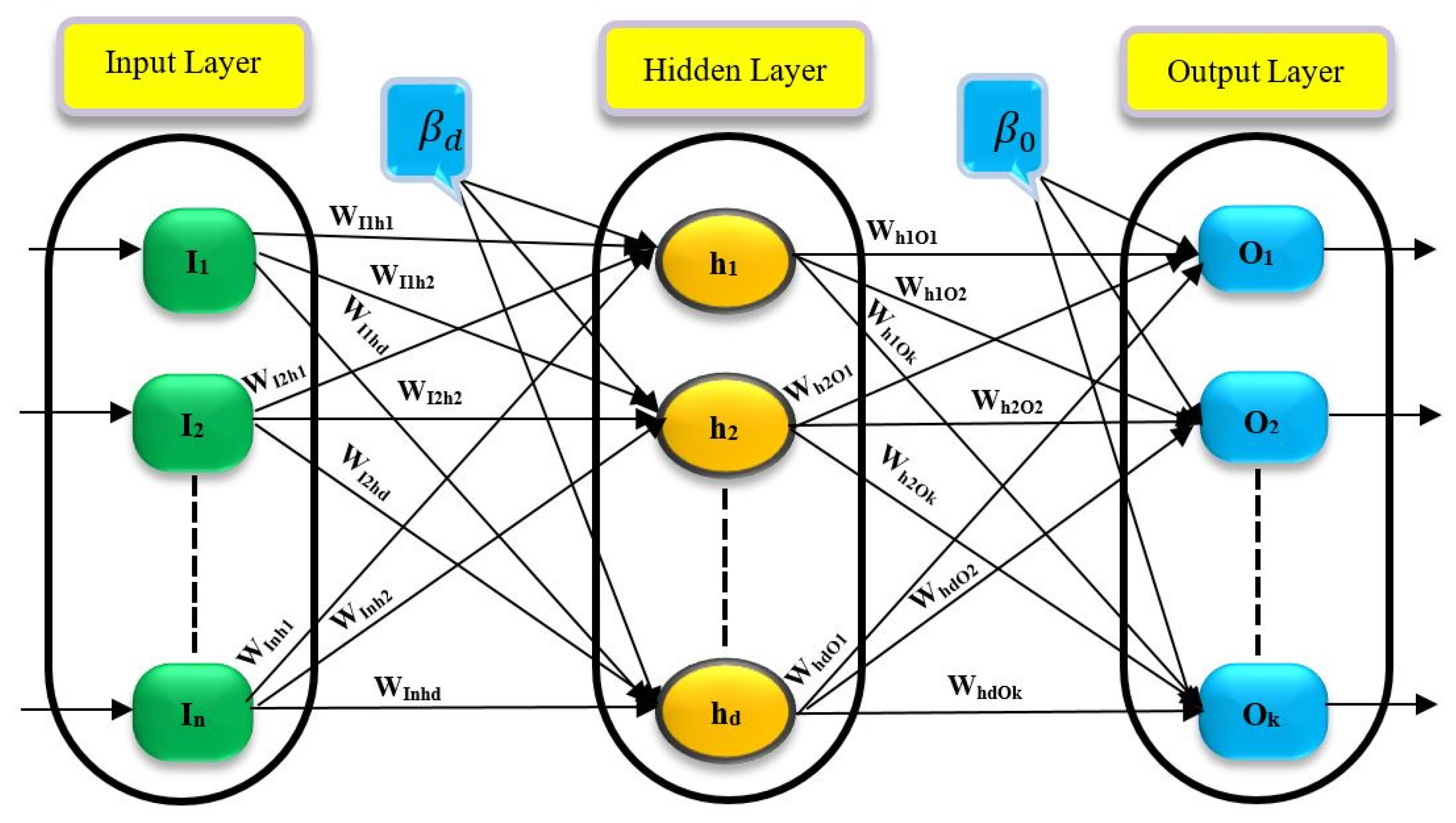
3. Artificial Neural Network (ANN)

The ANN algorithm is one of the most frequently used machine learning algorithms [31,32,33,34]. These networks have generated great interest due to the recent increase in computing power, which has rendered them virtually ubiquitous [35].
Many nonlinear problems can be solved by artificial neural networks (ANNs), which are mathematical models of the human nervous system that consist of input, hidden, and output layers. Multiple hidden layers are included in a network, enabling the network to perform processing and computation. The problem’s complexity determines the number of layers. A neural network is generally a collection of connected output and input units, each with a unique weight. The methodology for using ANN in groundwater recharge mapping involves several steps [36,37,38]. First, data related to groundwater recharge and relevant environmental parameters are collected from various sources. Next, the collected data is preprocessed to remove any inconsistencies or errors. Then, the preprocessed data is split into training and testing datasets, with the former being used to train the ANN model and the latter being used to test its accuracy. The ANN model is designed and configured with the appropriate number of input, hidden, and output layers. The training process involves optimizing the weights and biases of the ANN through a backpropagation algorithm to minimize the error between the predicted and actual groundwater recharge values. Once the training is complete, the model’s accuracy is evaluated using the testing dataset. The final step involves using the trained ANN model to generate groundwater recharge maps by inputting relevant environmental parameters and predicting the corresponding recharge values.
In Figure 1, an ANN is depicted alongside a hidden layer and some weights linking the layers. The following steps should be considered while calculating the output values. First, the sum of weights is defined by Equation (1), where I i is the input variable, w i j is the weight between I i , and neuron j, and β i   shows the input variable’s bias term.
S j = i = 1 n w i j I i + β i                                                  
In the second step, neurons in the hidden layers’ output values are computed using an activation function derived from a weighted sum of the received values (Equation (1)). A ReLU function is a common choice for such a function as:
f j   ( I ) = max ( 0 , S j )
where f j   is the ReLU function for neuron j and S j   denotes the sum of weights.
Finally, in order to determine the output of neuron j, we have:
O j = i = 1 k w i j f j + β j      
where O j   is the output of neuron j, f j   denotes the activation function for neuron j, w i j   defines the weight between the output variable O i   and neuron j, and β i   represents the bias term for the output variable.

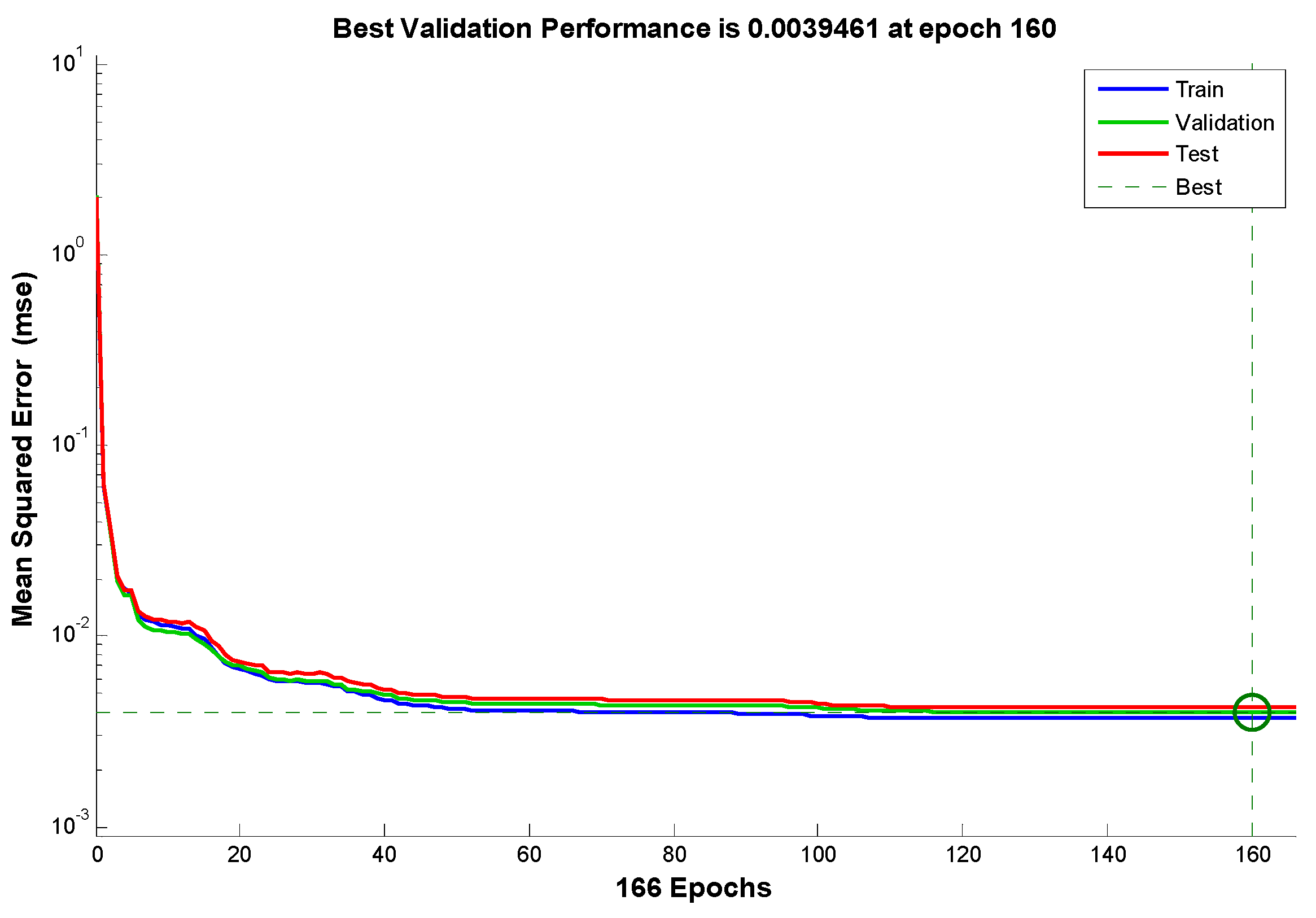
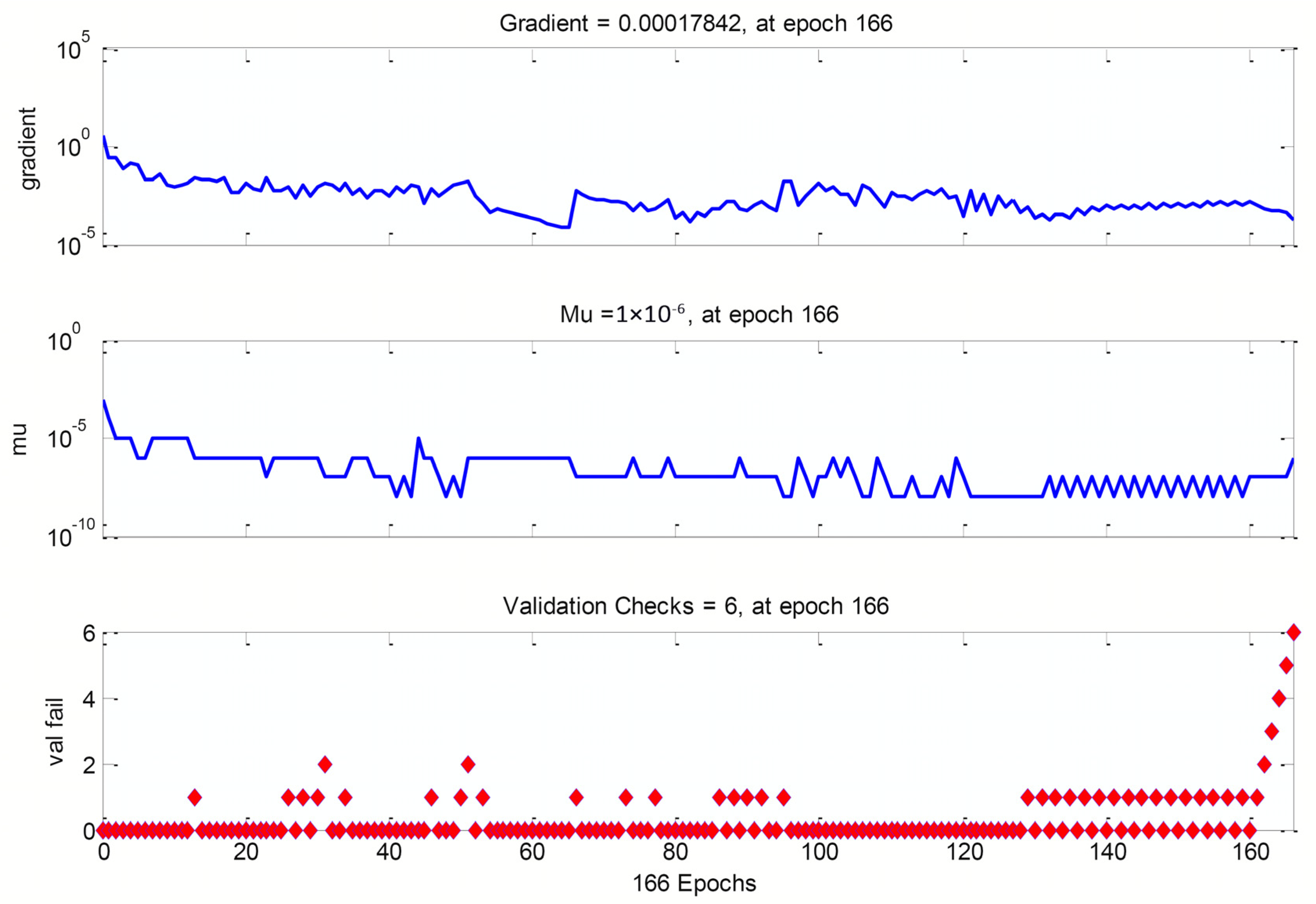
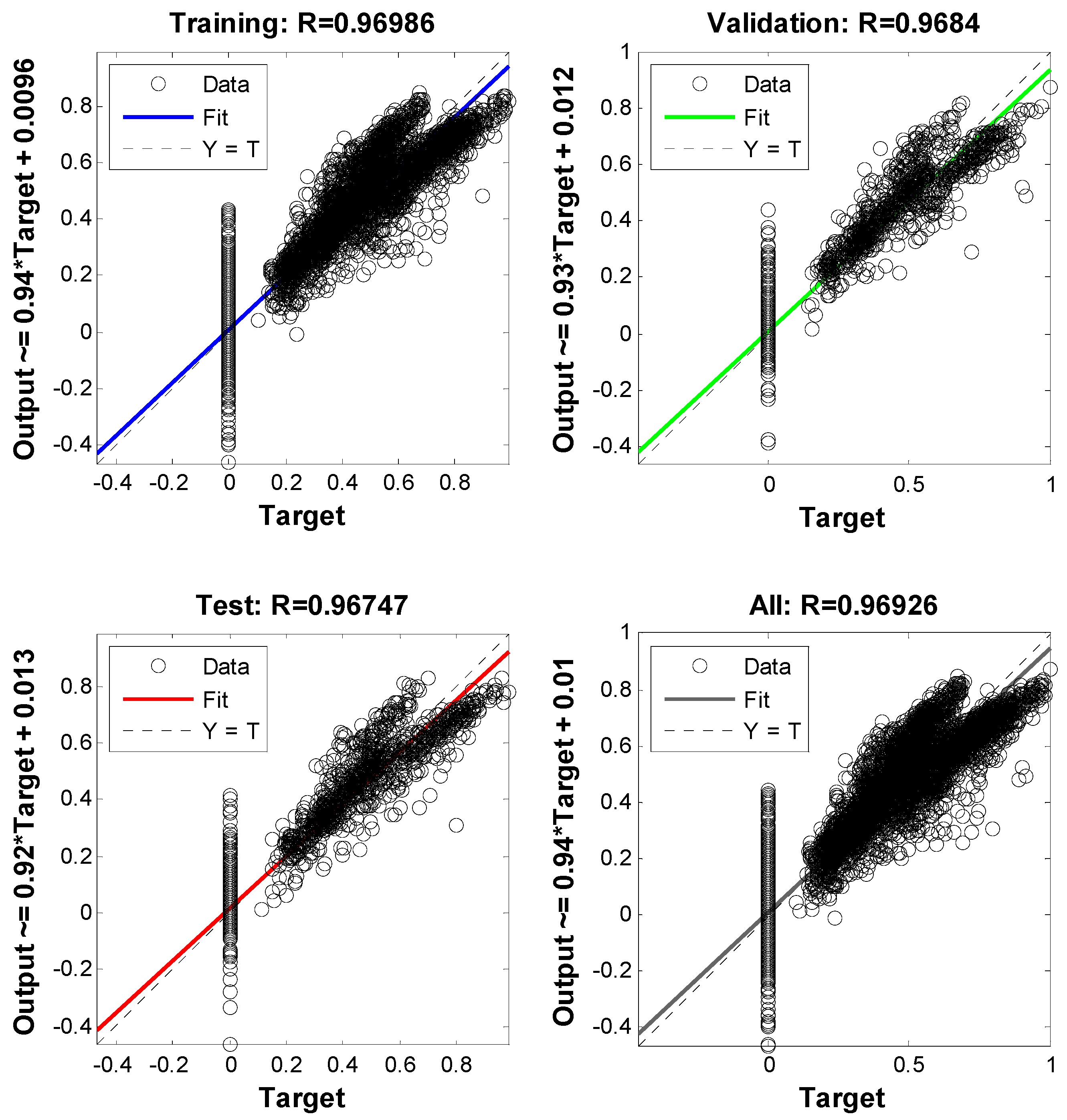
4. Results and Discussion

Groundwater recharge is essential in maintaining the balance of water resources in many regions worldwide. To ensure a sustainable groundwater supply, it is necessary to identify acceptable recharge areas. To achieve this, a computational intelligence technique has been introduced in this study. The technique involves collecting data on variables such as geology, unsaturated zone thickness, land use, distance from main rivers, precipitation, water quality, soil transmissivity, and slope maps. These variables were then classified into training, testing, and forecasting categories. Artificial neural networks (ANNs) were used to evaluate the dataset and identify acceptable recharge regions. ANNs are powerful tools that can model complex relationships between different variables without requiring any prior assumptions. The performance of the ANNs method was evaluated using the root mean squared error (RMSE), mean squared error (MSE), and correlation coefficient (R2). These evaluation metrics are widely used to measure the accuracy of ANN models in various studies [39,40]. The errors obtained from the evaluation process were presented as equations, providing a better understanding of the method’s accuracy in identifying acceptable recharge regions (4)–(6).
MSE = 1 / n   _ ( i = 1 ) n   × ( T a r g e t _ i   o u t p u t _ i ) 2
RMSE = ( 1 / n   _ ( i = 1 ) n   × ( T a r g e t _ i   o u t p u t _ i ) 2 )
R 2 = ( ( × ( T a r g e t _ i   ( T a r g e t ¯ ) ) × ( o u t p u t _ i ( o u t p u t ¯ )   ) ) / ( × ( T a r g e t _ i ( T a r g e t ) ) 2 × × ( o u t p u t _ i ( o u t p u t ) ) 2 ) ) 2
The best validation performance graph and regression plot of actual and predicted data using ANNs are shown in Figure 2, Figure 3 and Figure 4. The results of the performance evaluation of ANN outputs are displayed in Table 1 and Figure 5.
The ML algorithm’s performance curves are depicted in Figure 2 and Figure 3. There appear to be no issues with performance. There is no evidence of overfitting on either the validation or test curves. When comparing the training and validation curves, the training curve flattens out more quickly, indicating that the trained network performs better with learning data.
Regression analysis, where the network’s output is compared to the corresponding targets (often represented by a regression factor) is another method for gauging the generalization of a network (R). R = 1 (1.0) if the network performed perfectly; however, this is rarely the case. Figure 4 shows the regression plot with R = 0.9692.
When assessing the performance of a trained network, it is helpful to look at the error histogram, which shows the distribution of residuals between targets and network output. The majority of errors are found to be around 0.0036 in this case.

4.1. ANN Approach

The site selection process was carried out at different stages in this study. To train the system, 10% of the total study area was chosen, and then 1000 evenly-spaced points were randomly selected from this area. All the data introduced in the previous section was transferred to the machine learning system as a feature at each point. Seventy percent of these points were used for system training, and once the desired results were obtained with an acceptable error, the result was validated and tested on the remaining thirty percent of the data. Zaresefat et al. [41] obtained the results as the target for this step. After that, after ensuring the model’s accuracy, it was implemented for all the data in the region (Figure 6). As a result, the optimal locations for artificial groundwater recharge were determined.

4.2. Field Application and Future Research Perspective

The use of artificial neural networks (ANNs) in identifying suitable areas for artificial groundwater recharge has shown promise in providing a better delineation of areas for recharge. This study holds significant engineering significance by providing valuable insights and practical recommendations for experts and policy planners to identify appropriate locations for artificial groundwater recharge. The algorithm developed through this study utilizes machine learning techniques, which can provide high accuracy and low computational costs for identifying suitable sites. This not only saves time and resources but also increases the efficiency of the recharge process, leading to the conservation of groundwater resources and preventing the depletion of existing aquifers. The findings of this study can guide decision makers in developing effective policies and strategies for sustainable water resource management. These insights can also aid engineers in designing and implementing artificial groundwater recharge projects that are both feasible and economically viable. Furthermore, this study suggests that the machine learning algorithm can be applied to other regions, and the results can be compared with those of other available tools. In this way, it can contribute to developing more effective and efficient groundwater recharge projects, essential for ensuring water security and sustainability in arid and semiarid regions. While the use of ANNs in identifying potential sites for artificial recharge is a significant step forward, further investigation is necessary to confirm the suitability of these sites. Hydrogeological and geophysical investigations would be needed to provide a more indepth analysis of the subsurface conditions in these areas. A socioeconomic and financial appraisal would also need to be conducted to evaluate the feasibility and cost effectiveness of implementing artificial recharge in these areas.
To further expand on this work’s field application and future research prospects, it would be beneficial to have a separate section or subsection dedicated to this topic. In this section, the potential practical applications of the ANN approach could be discussed, including the use of the method in other regions and how the approach could be adapted to suit different geologic settings. Additionally, the approach’s limitations and areas for future research could be highlighted. This section would help contextualize the study’s findings and provide a roadmap for future research in this area.

5. Conclusions

The study used an artificial intelligence-based algorithm to identify suitable locations for artificial groundwater recharge in the Iranshahr plain. Nine input data layers, including lithology, land use, distance from main rivers, precipitation, water quality, soil transmissivity, and slope maps, were used to develop the algorithm. The results were compared to those obtained from the fuzzy analytic hierarchy process technique. The machine learning model showed higher accuracy and lower computational cost than the FAHP model. This study provides helpful suggestions and novel insights for experts and policy planners to identify suitable artificial groundwater recharge areas. The proposed method can be compared with other machine learning algorithms, such as support vector machines and decision tree random forests. Future studies should compare the proposed methods with traditional methods to identify new sites for viable and sustainable artificial groundwater recharge while increasing efficiency and conserving time and resources.

Author Contributions

M.Z. and R.D.: conceptualization, writing—original draft preparation, formal analysis, validation, methodology, investigation, and resources; V.N. and A.G.: writing—original draft preparation, visualization, software, and methodology; A.R.: supervision, writing—review and editing. All authors have read and agreed to the published version of the manuscript.

Funding

This research received no external funding.

Institutional Review Board Statement

Not applicable.

Informed Consent Statement

Not applicable.

Data Availability Statement

Not applicable.

Conflicts of Interest

The authors declare no conflict of interest.

References

  1. Green, T.R.; Taniguchi, M.; Kooi, H.; Gurdak, J.J.; Allen, D.M.; Hiscock, K.M.; Treidel, H.; Aureli, A. Beneath the Surface of Global Change: Impacts of Climate Change on Groundwater. J. Hydrol. 2011, 405, 532–560. [Google Scholar] [CrossRef] [Green Version]
  2. Arefin, R. Groundwater Potential Zone Identification at Plio-Pleistocene Elevated Tract, Bangladesh: AHP-GIS and Remote Sensing Approach. Groundw. Sustain. Dev. 2020, 10, 100340. [Google Scholar] [CrossRef]
  3. Nhamo, L.; Ebrahim, G.Y.; Mabhaudhi, T.; Mpandeli, S.; Magombeyi, M.; Chitakira, M.; Magidi, J.; Sibanda, M. An Assessment of Groundwater Use in Irrigated Agriculture Using Multi-Spectral Remote Sensing. Phys. Chem. Earth Parts A/B/C 2020, 115, 102810. [Google Scholar] [CrossRef]
  4. Zhang, K.; Xie, X.; Zhu, B.; Meng, S.; Yao, Y. Unexpected Groundwater Recovery with Decreasing Agricultural Irrigation in the Yellow River Basin. Agric. Water Manag. 2019, 213, 858–867. [Google Scholar] [CrossRef]
  5. Nabavi, E. Failed Policies, Falling Aquifers: Unpacking GroundwaterOverabstraction in Iran. Water Altern. 2018, 11, 699–724. [Google Scholar]
  6. Dalin, C.; Wada, Y.; Kastner, T.; Puma, M.J. Groundwater Depletion Embedded in International Food Trade. Nature 2017, 543, 700–704. [Google Scholar] [CrossRef] [Green Version]
  7. Sprenger, C.; Hartog, N.; Hernández, M.; Vilanova, E.; Grützmacher, G.; Scheibler, F.; Hannappel, S. Inventory of Managed Aquifer Recharge Sites in Europe: Historical Development, Current Situation and Perspectives. Hydrogeol. J. 2017, 25, 1909–1922. [Google Scholar] [CrossRef] [Green Version]
  8. Mahdavi, A.; Tabatabaei, S.H.; Mahdavi, R.; Nouri Emamzadei, M.R. Application of Digital Techniques to Identify Aquifer Artificial Recharge Sites in GIS Environment. Int. J. Digit. Earth 2013, 6, 589–609. [Google Scholar] [CrossRef] [Green Version]
  9. Olden, J.D.; Lawler, J.J.; Poff, N.L. Machine Learning Methods without Tears: A Primer for Ecologists. Q. Rev. Biol. 2008, 83, 171–193. [Google Scholar] [CrossRef] [Green Version]
  10. Kundu, M.; Zafor, A.; Maiti, R. Assessing the Nature of Potential Groundwater Zones through Machine Learning (ML) Algorithm in Tropical Plateau Region, West Bengal, India. Acta Geophys. 2023, 1–16. [Google Scholar] [CrossRef]
  11. Masroor, M.; Sajjad, H.; Kumar, P.; Saha, T.K.; Rahaman, M.H.; Choudhari, P.; Kulimushi, L.C.; Pal, S.; Saito, O. Novel Ensemble Machine Learning Modeling Approach for Groundwater Potential Mapping in Parbhani District of Maharashtra, India. Water 2023, 15, 419. [Google Scholar] [CrossRef]
  12. Jalaee, M.S.; Shakibaei, A.; Ghaseminejad, A.; Jalaee, S.A.; Derakhshani, R. A Novel Computational Intelligence Approach for Coal Consumption Forecasting in Iran. Sustainability 2021, 13, 7612. [Google Scholar] [CrossRef]
  13. Jalaee, S.A.; Shakibaei, A.; Akbarifard, H.; Horry, H.R.; GhasemiNejad, A.; Nazari Robati, F.; Amani zarin, N.; Derakhshani, R. A Novel Hybrid Method Based on Cuckoo Optimization Algorithm and Artificial Neural Network to Forecast World’s Carbon Dioxide Emission. MethodsX 2021, 8, 101310. [Google Scholar] [CrossRef] [PubMed]
  14. Taormina, R.; Chau, K.W.; Sivakumar, B. Neural Network River Forecasting through Baseflow Separation and Binary-Coded Swarm Optimization. J. Hydrol. 2015, 529, 1788–1797. [Google Scholar] [CrossRef]
  15. Mohanty, S.; Jha, M.K.; Raul, S.K.; Panda, R.K.; Sudheer, K.P. Using Artificial Neural Network Approach for Simultaneous Forecasting of Weekly Groundwater Levels at Multiple Sites. Water Resour. Manag. 2015, 29, 5521–5532. [Google Scholar] [CrossRef]
  16. Corsini, A.; Cervi, F.; Ronchetti, F. Weight of Evidence and Artificial Neural Networks for Potential Groundwater Spring Mapping: An Application to the Mt. Modino Area (Northern Apennines, Italy). Geomorphology 2009, 111, 79–87. [Google Scholar] [CrossRef]
  17. Pasandi, M.; Salmani, N.; Samani, N. Spatial Estimation of Water-Table Depth by Artificial Neural Networks in Light of Ancillary Data. Hydrol. Sci. J. 2017, 62, 2012–2024. [Google Scholar] [CrossRef]
  18. Kong-A-Siou, L.; Johannet, A.; Borrell Estupina, V.; Pistre, S. Neural Networks for Karst Groundwater Management: Case of the Lez Spring (Southern France). Environ. Earth Sci. 2015, 74, 7617–7632. [Google Scholar] [CrossRef]
  19. Jiang, Z.; Mallants, D.; Peeters, L.; Gao, L.; Soerensen, C.; Mariethoz, G. High-Resolution Paleovalley Classification from Airborne Electromagnetic Imaging and Deep Neural Network Training Using Digital Elevation Model Data. Hydrol. Earth Syst. Sci. 2019, 23, 2561–2580. [Google Scholar] [CrossRef] [Green Version]
  20. Alizadeh, M.J.; Kavianpour, M.R.; Danesh, M.; Adolf, J.; Shamshirband, S.; Chau, K.W. Effect of River Flow on the Quality of Estuarine and Coastal Waters Using Machine Learning Models. Eng. Appl. Comput. Fluid Mech. 2018, 12, 810–823. [Google Scholar] [CrossRef] [Green Version]
  21. Ye, L.; Gao, L.; Marcos-Martinez, R.; Mallants, D.; Bryan, B.A. Projecting Australia’s Forest Cover Dynamics and Exploring Influential Factors Using Deep Learning. Environ. Model. Softw. 2019, 119, 407–417. [Google Scholar] [CrossRef]
  22. Scher, S. Toward Data-Driven Weather and Climate Forecasting: Approximating a Simple General Circulation Model with Deep Learning. Geophys. Res. Lett. 2018, 45, 12–616. [Google Scholar] [CrossRef] [Green Version]
  23. Jiang, G.Q.; Xu, J.; Wei, J. A Deep Learning Algorithm of Neural Network for the Parameterization of Typhoon-Ocean Feedback in Typhoon Forecast Models. Geophys. Res. Lett. 2018, 45, 3706–3716. [Google Scholar] [CrossRef] [Green Version]
  24. Rahnama-Rad, J.; Bavali, M.Y.; Derakhshani, R. Optimization of Hydraulic Parameters of Iranshahr Alluvial Aquifer. Am. J. Environ. Sci. 2010, 6, 477–483. [Google Scholar] [CrossRef] [Green Version]
  25. Rahaman, M.H.; Sajjad, H.; Masroor, M.; Bhuyan, N.; Rehman, S. Delineating Groundwater Potential Zones Using Geospatial Techniques and Fuzzy Analytical Hierarchy Process (FAHP) Ensemble in the Data-Scarce Region: Evidence from the Lower Thoubal River Watershed of Manipur, India. Arab. J. Geosci. 2022, 15, 677. [Google Scholar] [CrossRef]
  26. Mukherjee, I.; Singh, U.K. Delineation of Groundwater Potential Zones in a Drought-Prone Semi-Arid Region of East India Using GIS and Analytical Hierarchical Process Techniques. Catena 2020, 194, 104681. [Google Scholar] [CrossRef]
  27. Doke, A.B.; Zolekar, R.B.; Patel, H.; Das, S. Geospatial Mapping of Groundwater Potential Zones Using Multi-Criteria Decision-Making AHP Approach in a Hardrock Basaltic Terrain in India. Ecol. Indic 2021, 127, 107685. [Google Scholar] [CrossRef]
  28. Chen, G. Agricultural Water Efficiency Evaluation Method Based on Remote Sensing Technology. Rev. Fac. Agron. Univ. Zulia 2019, 36, 1439–1450. [Google Scholar]
  29. Campos Pinto, L.; de Mello, C.R.; Norton, L.D.; Owens, P.R.; Curi, N. Spatial Prediction of Soil–Water Transmissivity Based on Fuzzy Logic in a Brazilian Headwater Watershed. Catena 2016, 143, 26–34. [Google Scholar] [CrossRef]
  30. Singh, L.K.; Jha, M.K.; Chowdary, V.M. Multi-Criteria Analysis and GIS Modeling for Identifying Prospective Water Harvesting and Artificial Recharge Sites for Sustainable Water Supply. J. Clean Prod. 2017, 142, 1436–1456. [Google Scholar] [CrossRef]
  31. Ray, S. A Quick Review of Machine Learning Algorithms. In Proceedings of the 2019 International Conference on Machine Learning, Big Data, Cloud and Parallel Computing (COMITCon), Faridabad, India, 14–16 February 2019; IEEE: Piscataway, NJ, USA, 2019; pp. 35–39. [Google Scholar]
  32. Razavi-Termeh, S.V.; Sadeghi-Niaraki, A.; Choi, S.M. Groundwater Potential Mapping Using an Integrated Ensemble of Three Bivariate Statistical Models with Random Forest and Logistic Model Tree Models. Water 2019, 11, 1596. [Google Scholar] [CrossRef] [Green Version]
  33. Lee, J.; Kim, C.G.; Lee, J.E.; Kim, N.W.; Kim, H. Application of Artificial Neural Networks to Rainfall Forecasting in the Geum River Basin, Korea. Water 2018, 10, 1448. [Google Scholar] [CrossRef] [Green Version]
  34. Nguyen, P.T.; Ha, D.H.; Jaafari, A.; Nguyen, H.D.; van Phong, T.; Al-Ansari, N.; Prakash, I.; van Le, H.; Pham, B.T. Groundwater Potential Mapping Combining Artificial Neural Network and Real Adaboost Ensemble Technique: The Daknong Province Case-Study, Vietnam. Int. J. Environ. Res. Public Health 2020, 17, 2473. [Google Scholar] [CrossRef] [PubMed] [Green Version]
  35. Arabameri, A.; Pal, S.C.; Rezaie, F.; Nalivan, O.A.; Chowdhuri, I.; Saha, A.; Lee, S.; Moayedi, H. Modeling Groundwater Potential Using Novel GIS-Based Machine-Learning Ensemble Techniques. J. Hydrol. Reg. Stud. 2021, 36, 100848. [Google Scholar] [CrossRef]
  36. Rabet, A.; Dastranj, A.; Asadi, S.; Asadi Nalivan, O. Determination of Groundwater Potential Using Artificial Neural Network, Random Forest, Support Vector Machine and Linear Regression Models (Case Study: Lake Urmia Watershed). Iran. J. Ecohydrol. 2020, 7, 1047–1060. [Google Scholar]
  37. Siabi, E.K.; Dile, Y.T.; Kabo-Bah, A.T.; Amo-Boateng, M.; Anornu, G.K.; Akpoti, K.; Vuu, C.; Donkor, P.; Mensah, S.K.; Incoom, A.B.M.; et al. Machine Learning Based Groundwater Prediction in a Data-Scarce Basin of Ghana. Appl. Artif. Intell. 2022, 36, 2138130. [Google Scholar] [CrossRef]
  38. Bui, D.T.; Shirzadi, A.; Chapi, K.; Shahabi, H.; Pradhan, B.; Pham, B.T.; Singh, V.P.; Chen, W.; Khosravi, K.; Bin Ahmad, B.; et al. A Hybrid Computational Intelligence Approach to Groundwater Spring Potential Mapping. Water 2019, 11, 2013. [Google Scholar] [CrossRef] [Green Version]
  39. Mallick, J.; Khan, R.A.; Ahmed, M.; Alqadhi, S.D.; Alsubih, M.; Falqi, I.; Hasan, M.A. Modeling Groundwater Potential Zone in a Semi-Arid Region of Aseer Using Fuzzy-AHP and Geoinformation Techniques. Water 2019, 11, 2656. [Google Scholar] [CrossRef] [Green Version]
  40. Abd-Elmaboud, M.E.; Abdel-Gawad, H.A.; El-Alfy, K.S.; Ezzeldin, M.M. Estimation of Groundwater Recharge Using Simulation-Optimization Model and Cascade Forward ANN at East Nile Delta Aquifer, Egypt. J. Hydrol. Reg. Stud. 2021, 34, 100784. [Google Scholar] [CrossRef]
  41. Zaresefat, M.; Ahrari, M.; Reza Shoaei, G.; Etemadifar, M.; Aghamolaie, I.; Derakhshani, R. Identification of Suitable Site-Specific Recharge Areas Using Fuzzy Analytic Hierarchy Process (FAHP) Technique: A Case Study of Iranshahr Basin (Iran). Air Soil Water Res. 2022, 15, 11786221211063849. [Google Scholar] [CrossRef]
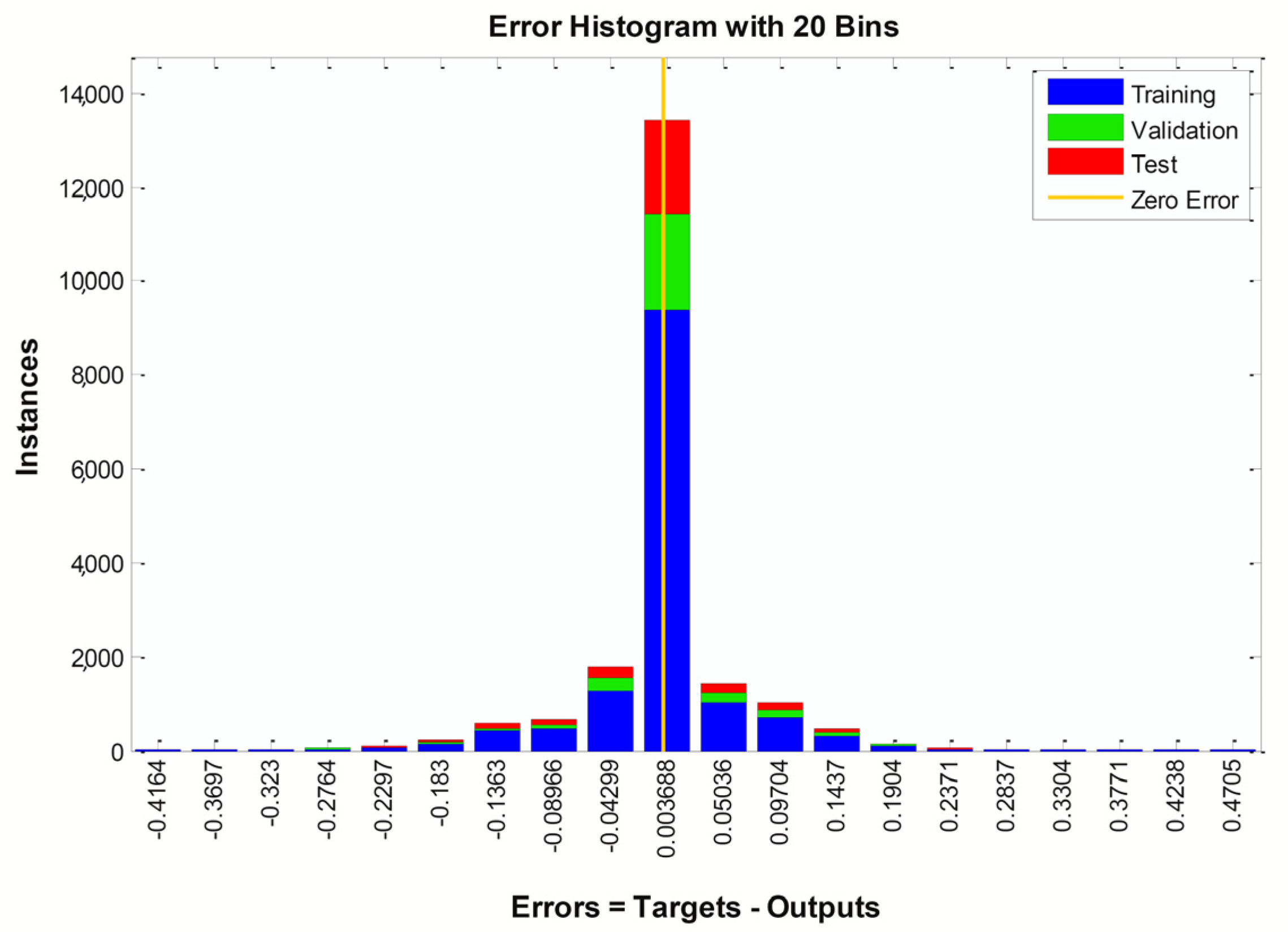
Figure 1. A three-layer ANN.
Water 15 01182 g001
Figure 2. Validation Performance plot.
Water 15 01182 g002
Figure 3. Data output and model performance criteria optimised via neural networks.
Water 15 01182 g003
Figure 4. Regression Plot.
Water 15 01182 g004
Figure 5. Error Histogram for ANN outputs.
Water 15 01182 g005
Figure 6. Artificial Groundwater Recharge site suitability map.
Water 15 01182 g006
Table 1. ANN operation.
BGWAN ProcessData UsageMSERMSER
training70%3.71359 × 10−30.0609390.969864
validation15%3.94606 × 10−30.0628180.968400
testing15%4.20498 × 10−30.0648460.967469
Disclaimer/Publisher’s Note: The statements, opinions and data contained in all publications are solely those of the individual author(s) and contributor(s) and not of MDPI and/or the editor(s). MDPI and/or the editor(s) disclaim responsibility for any injury to people or property resulting from any ideas, methods, instructions or products referred to in the content.

