1. Introduction
Fresh water is one of the essential elements of human life. This is why nearly all civilizations seem to have started near the rivers: for easy accessibility to fresh water. The same thing also applies to the Penang state in Malaysia, that is populated by approximately 1.8 million people. The Penang state water supply relies mostly on the Muda River, which originates in the Kedah state and empties into the Penang state. However, the Penang state has recently been hit by much bad news relating its water resource, regarding changes in logging policy at the Muda River catchment, which may affect the base flow of the Muda River, along with climate change that affects the total rainfall of both Air Itam and Teluk Bahang Dam [
1]. Based on the projection analysis and economic growth, it is forecast that there will be a significant increase in water demand in the future [
2]. Due to these facts, the state government has shown interest in finding a new water source to accommodate potable water for its people. The Perai River basin, which originated in Kulim and flows south to Butterworth, is the largest basin in the Penang state. Thus, the possibility to use water from the Perai River has been considered as an option for tapping this new source.
It is usually a challenge for the local authorities to determine the river’s assimilative capacity or, in other words, the quantity of pollutant load that can be delivered to the water body without violating water quality requirements or damaging the aquatic life when there is a development [
3,
4]. A water body has potential to naturally absorb and use a substance that has been released without affecting its water quality or aquatic life [
5,
6]. Since, the assimilative capability is considered a site-specific characteristic associated with particular water bodies [
7,
8], the most common method to measure and manage a river’s assimilative capacity or stream is using the total maximum daily load (TMDL) [
9].
The TMDL determines the maximum amount of a pollutant that can enter a water body while still allowing the water body to maintain water quality criteria for that specific pollutant [
4]. A TMDL determines a pollutant reduction target and allocates load reductions necessary for the sources of the pollutant [
10,
11,
12]. Pollutant sources are characterized as either point sources that receive a waste load allocation (WLA) or non-point sources that receive a load allocation (LA) [
7]. At the same time, TMDLs must also consider seasonal water quality variations and include a margin of safety (MOS) to account for uncertainty in predicting how well pollutant reductions will result in fulfilling water quality standards. A good TMDL process should also include an assessment of the water body characteristics, communicating with the communities affected by the water body, and developing a plan to remediate the pollution problem over time [
13,
14,
15]. Thus, the TMDL can be understood as a calculation of the point and non-point source loadings that are allowable in a water body, while implementing a water quality improvement plan.
Unfortunately, it has been seen that urbanization has influenced particular areas of the basin viz, such as Butterworth and Perai, as industrial areas. In fact, most of these areas have been developed without considering the impact on the receiving water body. The Perai River is approximately 60.5 km long and the basin covers approximately 447 km
2 of both the state of Penang and Kedah areas. The upstream part of the basin, filled with agriculture and animal husbandry, continues adding waste to the river system. As a result, the pollution exceeds the assimilative capacity and disturbs the river’s life. Various industries sprouted up over the decades, with economic growth to support the country’s economy. Unfortunately, the river and its tributaries were ignored and turned into a disposal channel, washing the waste away during rainy seasons. Finally, the river has become polluted and water quality has deteriorated over the years [
16].
For a long time, the water quality index (WQI) was used as a key indicator to monitor the scale of the river’s cleanliness. However, the WQI is limited only to monitoring the river and does not quantify the load flowing of the river. Current environmental legislation does not emphasize the number of pollutants that can be discharged. The water quality management program needs the information of the load to develop a suitable and practical approach to reduce pollution levels in a river. That is when TMDL play its role. This method is used worldwide and has proven useful in managing water quality. The United States of America is one of the leading countries using this method to solve river pollution [
17,
18].
Numerous analyses using tools such as hydrodynamic modeling were conducted in the Perai River basin. However, most of the modeling program was dedicated to studying flood risk and management. Water quality modeling needs to be conducted in the river to understand the variation of pollution levels due to changes in rainfall and tidal effect during the year. At the same time, data generated from the model can be used to formulate the TMDL for the river. Therefore, this paper aims to study the pollution level variation due to changes in rainfall over the year and estimate the TMDL of the river in a particular case for BOD, COD, and NH3N parameters. This study was necessary to provide the TMDL based on several hydrological conditions, which may help in developing action plans to manage river water quality issues.
2. Materials and Methods
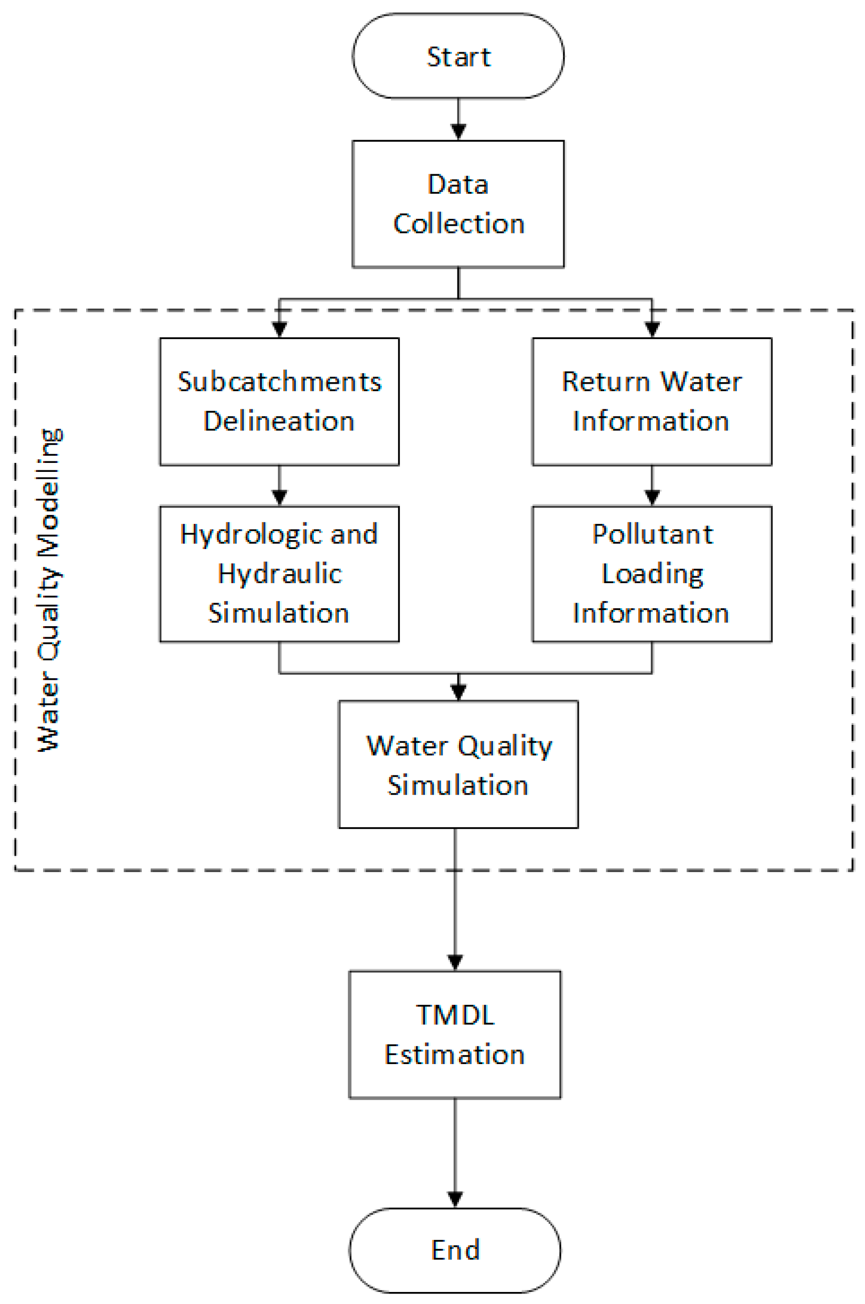
2.1. Water Quality Modeling Workflow
There are three main components of the study: (1) data collection, (2) water quality modeling and (3) TMDL estimation.
Figure 1 visualizes the workflow of this study.
2.2. Water Quality Data
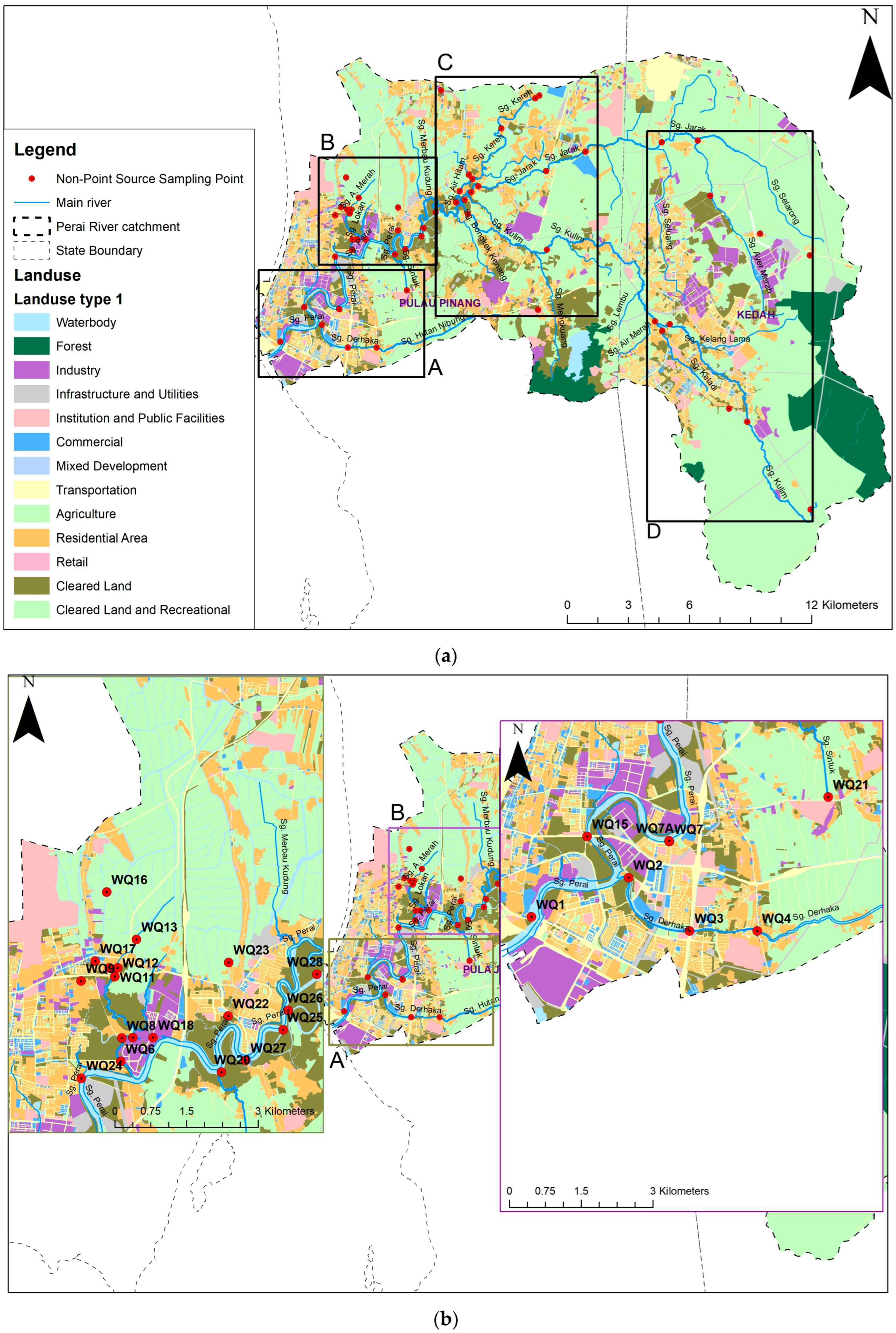
The water quality of the Perai River and its tributaries have been subjected to periodic monitoring and assessment by the Department of Environment (DOE), Malaysia. Data of nine stations were analyzed within the Perai River basin and the water quality at these stations was monitored six times a year. The stations are usually situated downstream of known point pollution sources to monitor the river quality. Data received from DOE was further analyzed using WQI to evaluate the existing condition of the river and for model validation.
The primary data was made via sampling at the Perai River. The main parameters involved are COD, BOD and NH
3N. The concentration data were essential to be input for water quality model development. The location of the sampling station is visualized in
Figure 2.
2.3. Hydrological Model Development
The water quality modeling carried out in this project is based on long-duration simulation, which covers one year. In this case, the year 2016 was chosen. By doing this exercise, the simulation covered the wet, dry and in intermediate seasons. A good rainfall–runoff model for a long duration was developed using the probabilistic distribution model (PDM). The PDM considers the soil moisture condition prior to the storm event. The main input for the model is continuous rainfall, daily evaporation and soil maximum and minimum storage capacity [
19]. The model then computes the amount of infiltration and direct runoff. The model will update the soil moisture content and ground water storage during the process. The formula that had been used in this PDM was Pareto distribution. Pareto distribution is widely used in practice in the ICM PDM model. The final output was the surface runoff and baseflow, while soil moisture content was used for the next event computation [
20,
21]. The formula is expressed as per Equation (1).
where:
= Volume of direct runoff
= Wet interval
= Maximum rate of recharge
= Critical capacity
= Maximum moisture store capacity
The PDM parameter used for each sub-catchment varied depending on the catchment length, slope, and land use. These values were adopted after various simulations during the calibration process. Too many parameters required calibration; however, since automatic calibration is impossible to carry out, manual calibration was done. Therefore, only a few significant parameters were adjusted to match the observed. The significant PDM parameters were: minimum moisture store capacity, Cmin; maximum moisture store capacity, Cmax; time constant surface, K1; and time constant surface flow storage, K2 [
22,
23]. These parameters influenced the infiltration and time of the rising hydrograph.
Simulation of hydrologic and hydraulic needs of the river, and drainage, digital terrain model (DTM), land use, population, and hydrological data were required. All data were collected from several government agencies.
2.4. Calibration and Validation Data
The purpose of the calibration was to determine whether the parameters adopted in the model showed a good response toward the rain input. Observed streamflow data recorded by the Department of Irrigation and Drainage (DID) were used to compare runoff results from the PDM simulation via statistical analysis. The involved software that processed the statistics was SPSS 27 version.
The validation method was similar to the calibration. Simulated water quality parameters in analysis points were validated with DOE data. They were then statistically analyzed via residual plot and linear regression.
2.5. Water Quality Modeling
Water quality model development focused on data input of return water. The model was generated using InfoWorks ICM. The minimum and maximum concentration of the parameters in the dry and wet seasons are listed in
Table A1 and
Table A2 of
Appendix A.
Figure 3 visualizes the general schematic of data input in the water quality model.
Sullage water, also known as return water, mainly comes from residential areas [
24,
25]. As a preliminary estimation, the sullage water distribution is based on the paper “Untreated sullage from residential areas—a challenge against inland water policy in Malaysia” [
26].
Al-Mamun et al. [
26] provided the hourly sullage water flow from the study area located in Taman Sri Serdang, with an area of about 6.14 ha. The study area is a residential area with a typical Malaysian housing scheme in an urban setting, which consists of 283 units of single-story terrace houses. The area was developed in 1981 and all sullage from the houses is discharged into a nearby detention pond, which flows into the receiving Kuyoh River. Sewage from the houses is conveyed by a separate sewer line and treated in an oxidation pond. Selangor Water Management Board Limited provides all houses with potable water. The total population served in the area was calculated at 1448-person equivalent (or 236-person equivalent per ha).
Return water from each sub-catchment was estimated based on land-use activity and various guidelines and manuals, i.e., the SPAN manual and water demand information from the local authority. The value for each source (point source and non-point source) was based on other references.
2.6. Total Maximum Daily Loads
Mathematically, the TMDL equation is expressed as per Equation (2). Meanwhile, pollution loading of point sources and non-point sources can be computed using Equation (3) [
27]. Water assimilative capacity (WAC) was also defined by the multiplication of flowrate and concentration.
where:
WLA = Sum of waste load allocations (point sources) (kg/day)
LA = Sum of load allocations (non-point sources and background) (kg/day)
The MOS of the WQI refers to class II as the limit value for water intake. Class II is classified as a water supply that needs conventional treatment and is suitable for sensitive aquatic species to live in. A MOS value of 10% was used in this calculation. In Malaysia, there are 6 parameters involved in WQI classification. As mentioned before, 3 parameters of the WQI were discussed: NH
3N (0.3 mg/L), BOD (3 mg/L), and COD (25 mg/L), as reference values for water quality pattern analysis. DOE Malaysia has classified the WQI value into 5 classes, as shown in
Table 1.
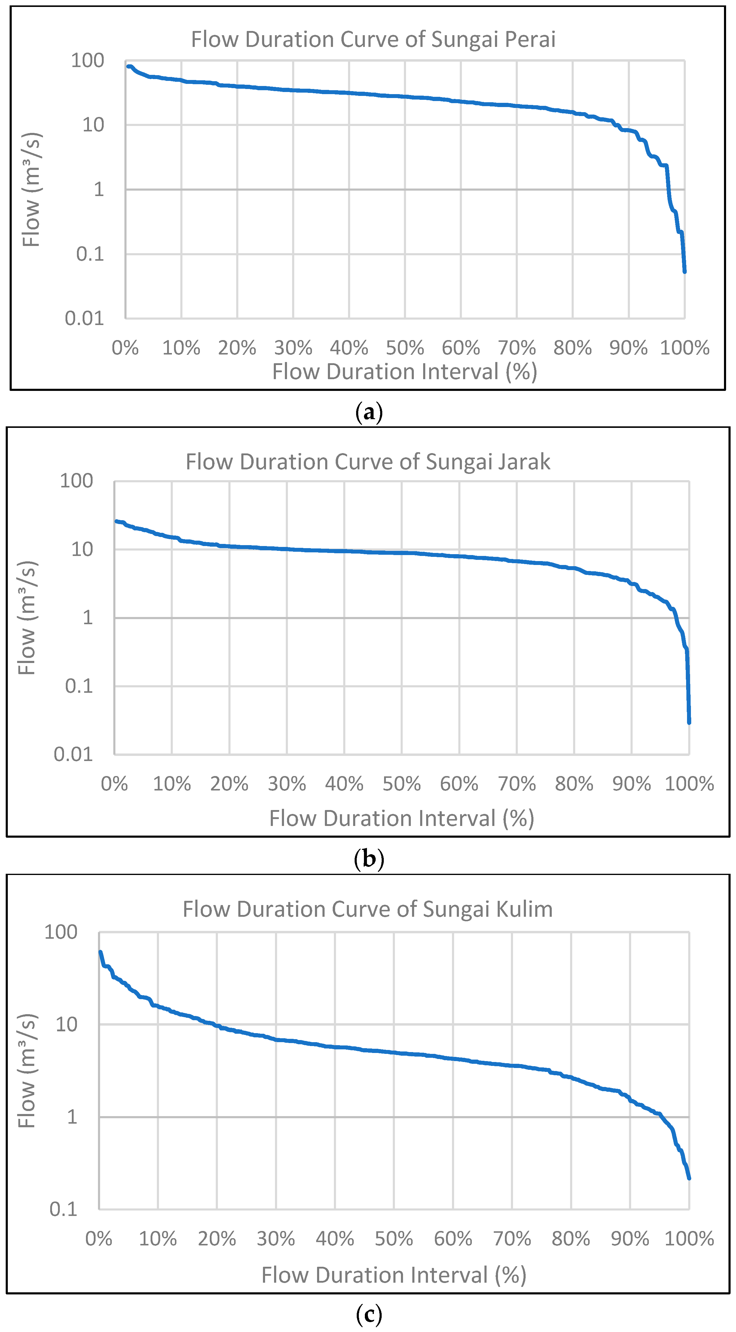
The TMDL estimation in this study was done using the load duration curve approach. The duration curve approach provides a better understanding of pollution loading and river flow. The flow duration curve (FDC) was developed based on simulation data. Information from FDC is crucial in determining the hydrological condition classes of the river: high flow (0–10% FDC); moist condition (10–40% FDC); mid-range condition (40–60% FDC); dry condition (60–90% FDC); and low flow (90–100%) [
28]. FDC was further analyzed to estimate the pollution loading for each scenario. The concentration for each class was then estimated from the 90th percentile. Not focusing on high and low-flow classes is recommended, as both are extreme conditions. Thus, the analysis is more focused on mid-range conditions.
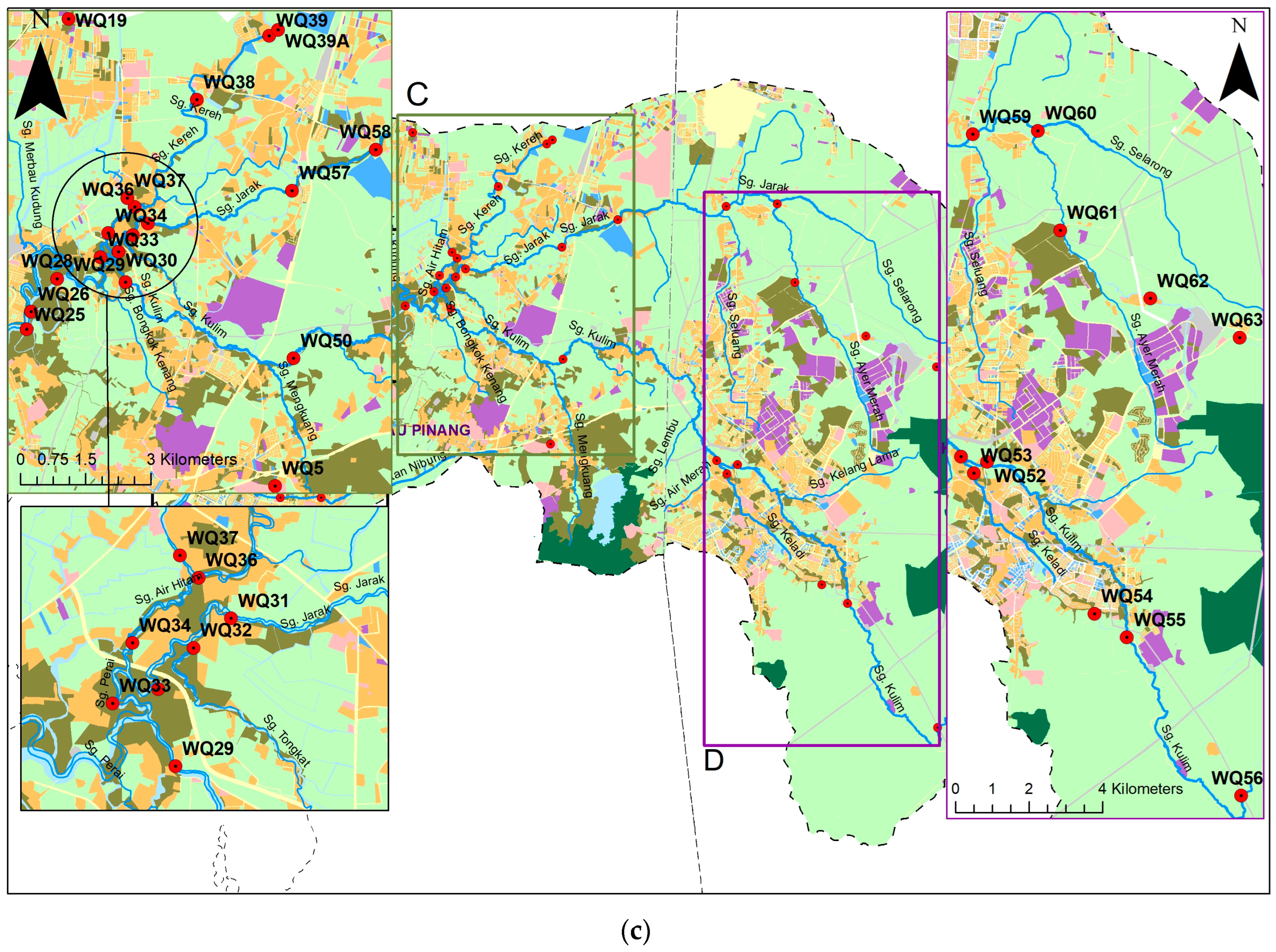
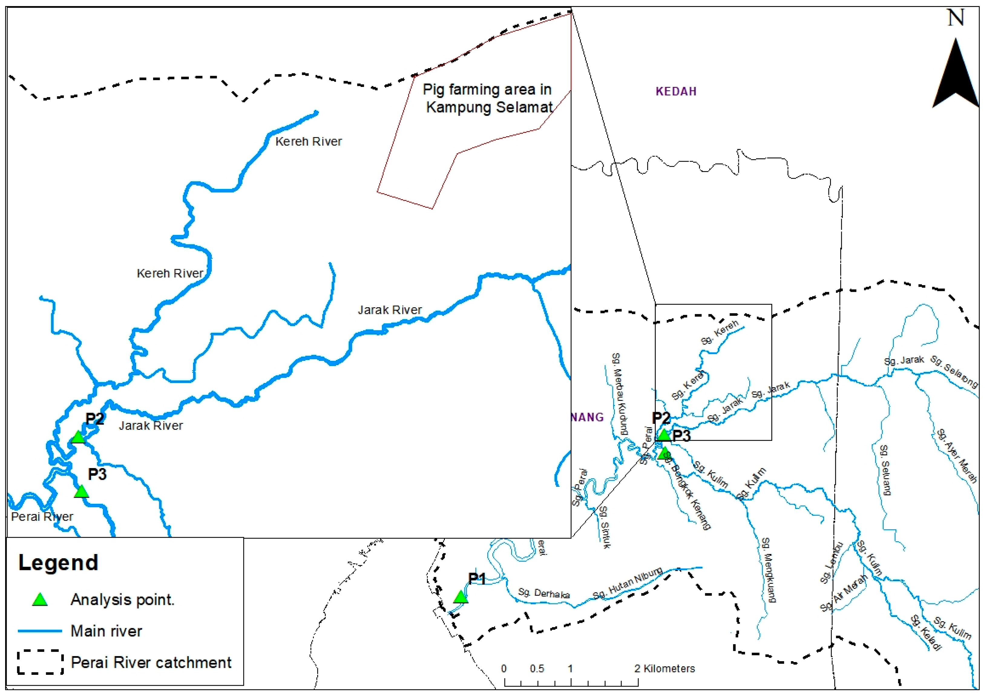
The TMDL estimation was done on three main rivers in this basin: Perai River, Jarak River and Kulim River. The estimation was based on the location of the analysis point, as shown in
Figure 4. There are three analysis locations: P1, represented downstream of the Perai River; P2, downstream of the Jarak River; and P3, located downstream of the Kulim River.
Figure 4 also shows the location of upstream Kereh River flows in the Jarak River. The details of the three points are tabulated in
Table 2.
3. Results and Discussion
3.1. Calibration of Simulated Flow Data
The tidal effect can be observed downstream of the Perai River and its tributaries, as shown in
Figure 5. Thus, backflow data (negative value flow) were filtered from the simulated result to achieve a more reasonable estimation.
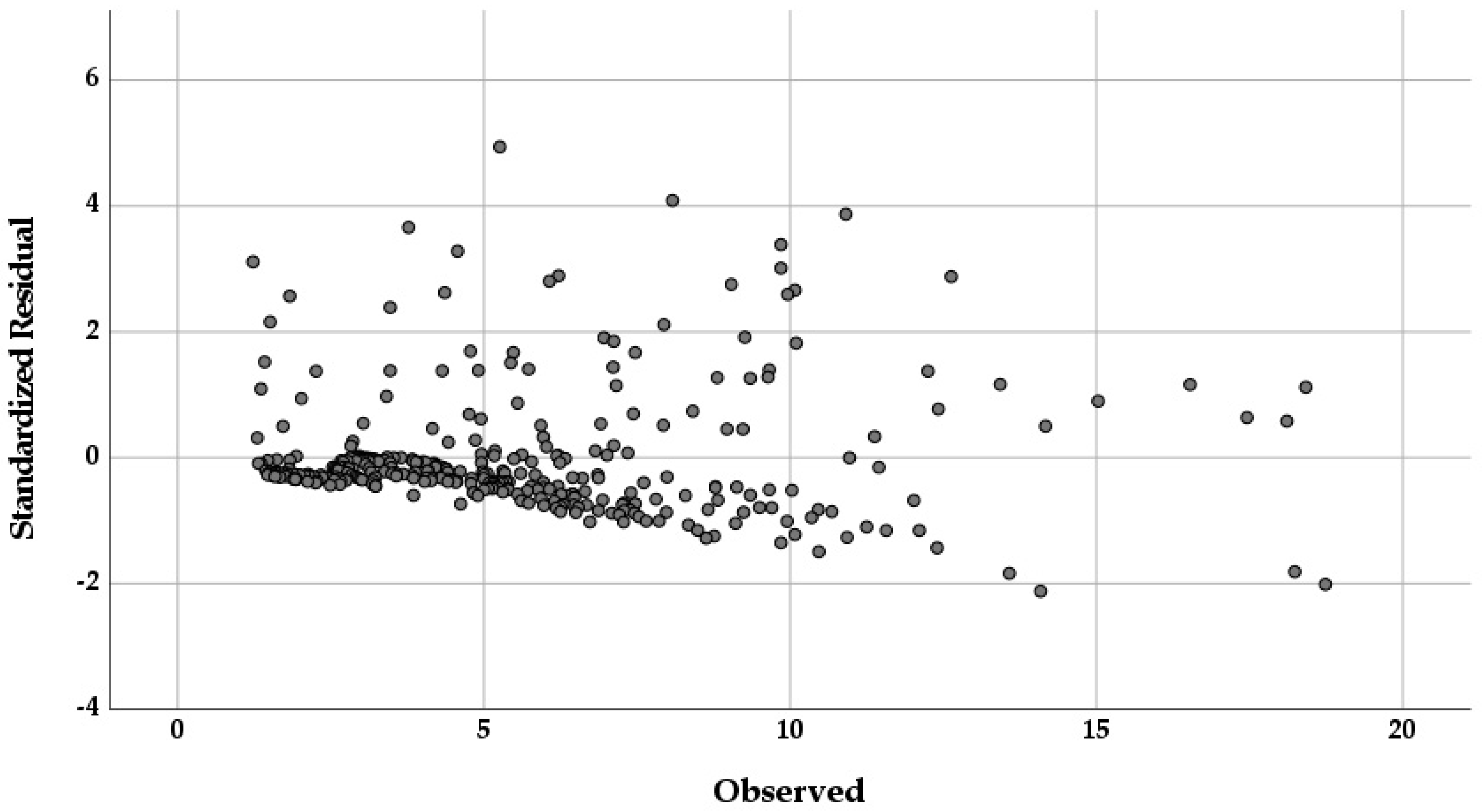
Based on the residual plot in
Figure 6, which exhibits heteroscedasticity, the residuals get larger as the prediction (observed data) moves from small to large or otherwise. From this analysis, the residual was larger when the observed data were increased due to the outlier caused by uncertain weather and extreme events. Some outliers have been cleaned using the z-score method to achieve parametric data. However, heteroscedasticity was still formed, resulting from missing variables or sample data. The sample size could have been reduced if it is more than 250. For instance, this sample size was reduced from 366 to 333.
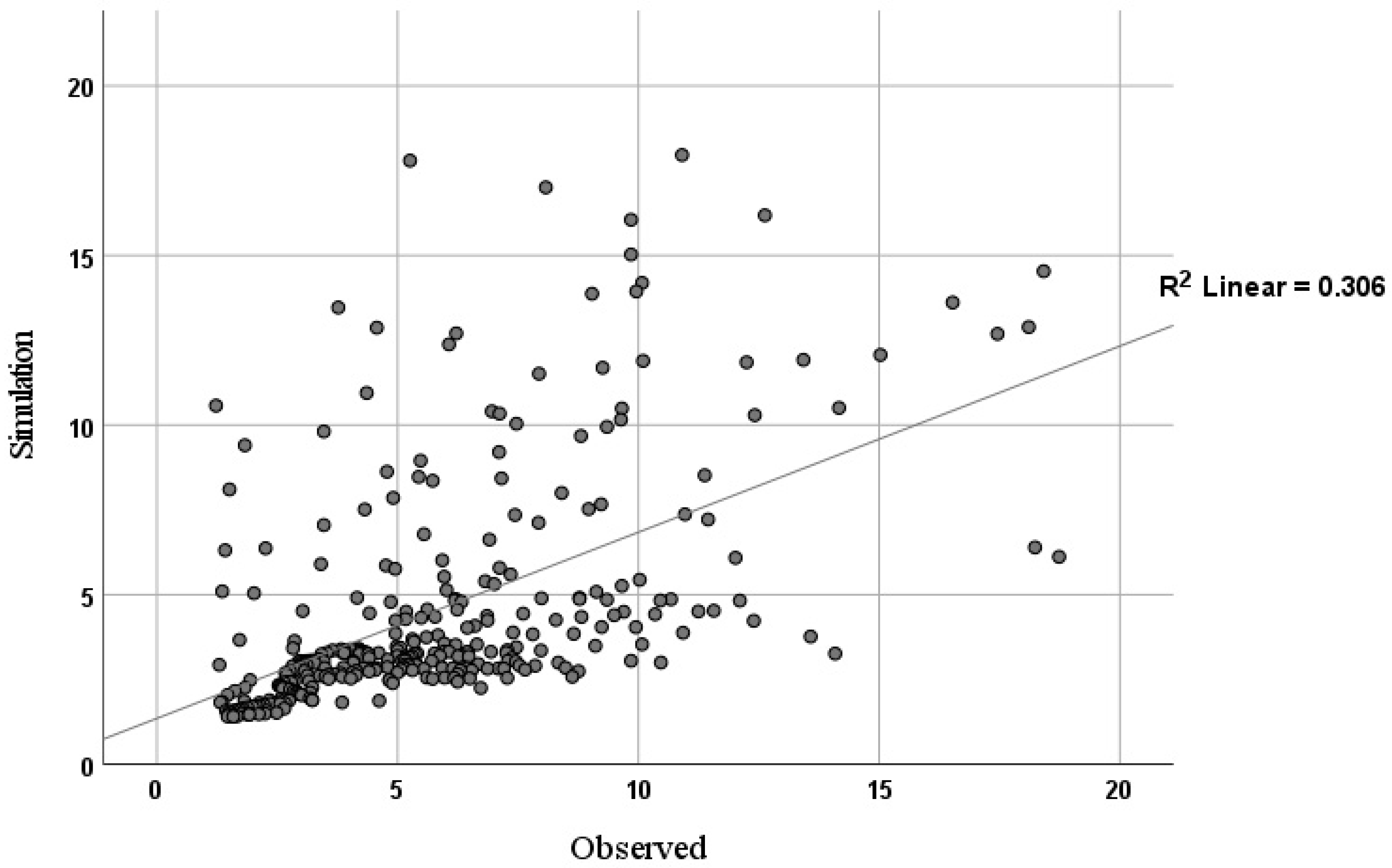
Based on the goodness of fit from the linear regression model in
Figure 7, the R-squared value is 0.306. This indicates that the model cannot explain 70% of the variability in the outcome data due to the high flow. However, a clear pattern was shown in the residual and goodness of, whereby most of the low flow concentrated near the line. This indicates that the model is unbiased, but has low accuracy and potentially room for improvement. The
p-value in the regression model is statistically significant, with a value of 4.2467 × 10
−28. Moreover, the Pearson correlation suggests that the observed and simulated values have a moderate correlation, with a value of R = 0.533. Therefore, this simulation data can be used and trusted in the water quality model.
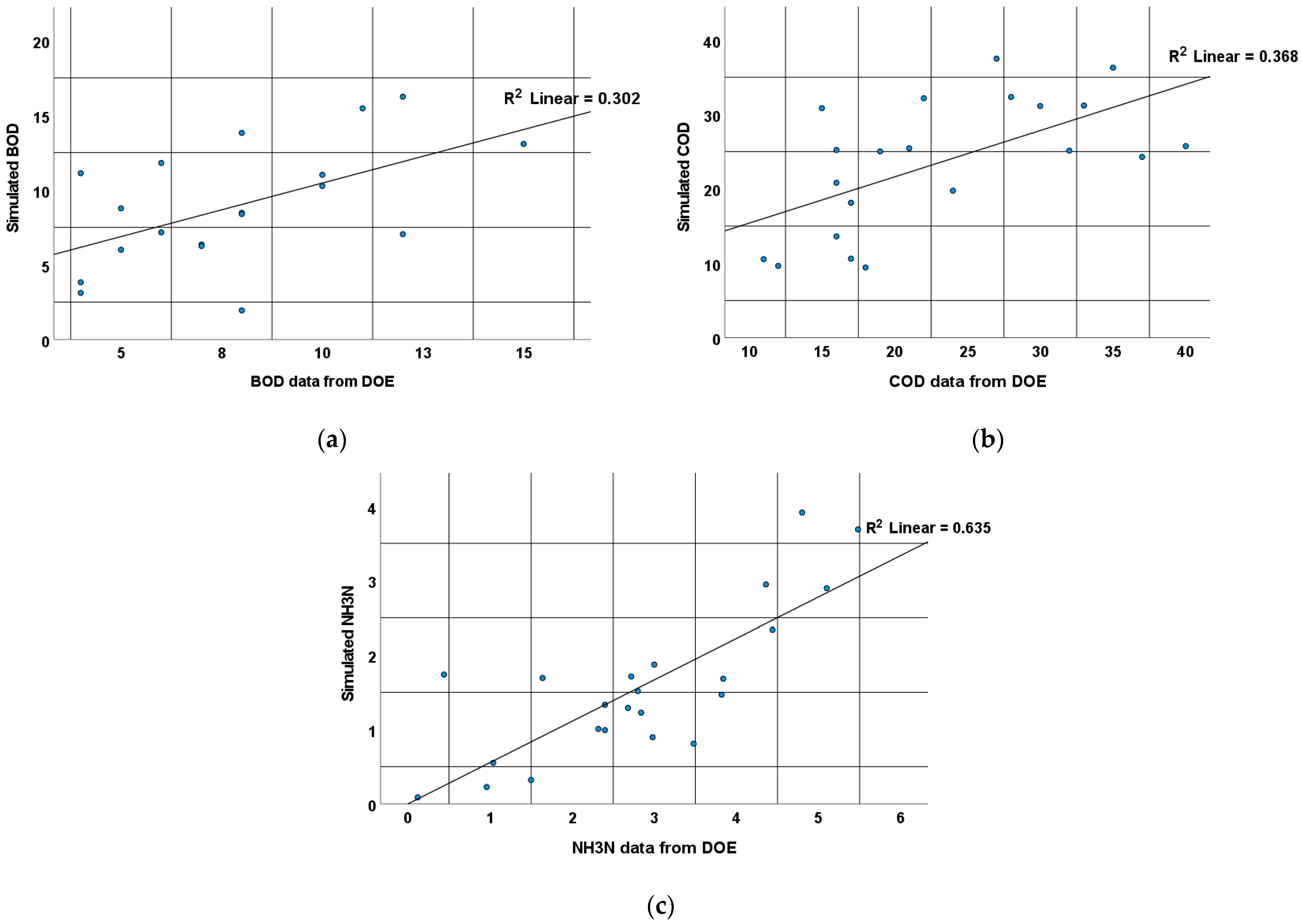
3.2. Validation of Simulated Water Quality Data
Based on the regression model in the
Table 3, all the models are normal and statistically significant, with a
p-value < 0.5. NH
3N showed strong correlation and a good model, with values of 0.797 and 0.635, respectively. On the other hand, BOD and COD illustrated weak models in
Figure 8, with values of 0.302 and 0.368, respectively. However, the correlation seems moderate to strong, which encourages considering accepting the models.
3.3. TMDL of the Perai River
The Perai River (analysis point 1) flow and water quality depend on the pollution from the catchment and pollution from the sea. This location is sensitive to the tidal effect. The effect not only impacts the flow and depth of the water body, but also the water quality, as during a high tide, the pollution from the sea may enter the river and travel upstream. Negative value flows that represent high-tide-related backflow are eliminated from the results before the calculation is completed. Instead of focusing on the sea, this study’s objective is to quantify the reduction from the upstream area. Because the TMDL is concentrated on the pollution caused by activities on the mainland, only positive flow values were taken into account. Based on
Table 4, the lowest load can be observed during low-flow conditions. However, the concentration is currently the highest. This happens due to less water, resulting in less load being transferred per second. The highest load for BOD and COD was observed during moist conditions, while NH
3N had the highest load during high-flow conditions. Both conditions reflect the rainy season, which could assume that most of the incoming load from upstream of the Perai River is a non-point source pollution.
All parameters exceed waste assimilative capacity (WAC) for all hydrological conditions during high flow, except COD. The exceedance was the highest during the rainy season and lowest during the dry season. In order to manage the river according to Class II, the required reduction of BOD is 81.6% (during moist conditions) and 95.9% for NH
3N (during high-flow conditions). Less reduction is needed for COD (only 43% during low flow). All reductions were based on the upstream, and the management program should consider pollutants from the sea for the Perai River condition. In this simulation result, the backflow data have been filtered to represent upstream pollution. The pollutants flowed downstream at the beginning of the low tide and may be the result of seawater intrusion from the high tide. Increase of COD can be caused by the interference of the chloride ions (Cl-), especially in samples with high salinity [
29].
3.4. TMDL of the Jarak River
Analysis point 2 represents the lowest point of the river before it enters the Perai River. It means the pollution discharged from the catchment and transported to the Perai River will pass the station. The highest concentration was observed to be during the mid-range condition. However, based on
Table 5, the highest load was observed during high-flow conditions. From the land-use analysis, this catchment contained a big portion of agriculture and residential area. Both activities may lead to huge river loads, especially during storm events. Under other conditions, return water from the residential area may reduced the water quality of the river. However, one of the prominent pollution sources in the Perai River is pig farming in Kampung Selamat (Kereh River). The Kereh River has been reported to have several water quality problems, and most conclude that the pollution comes from pig farming activity, which is located at the most upstream of the Kereh River, as shown in
Figure 4.
All parameters exceed WAC for all hydrological conditions. The load exceedance was the highest during the rainy season and lowest during the dry season. However, the mid-range condition showed the highest requirement for percentage reduction. To manage the river according to Class II, the reduction required for BOD and COD are 66.7% and 39.1%, respectively. A huge reduction is needed for NH3N, of up to 94.3%. NH3N is a major water quality problem, especially when extracting water for domestic usage, as it is not only bad for human consumption, but also not economical to be treated for drinking water. The possible sources of NH3N in the Jarak River are return water from residential areas located at the Seluang River and Ayer Merah River catchments, and pig farming in the Kereh River catchment. By managing these two activities, the NH3N load in the river may be reduced.
3.5. TMDL of the Kulim River
Analysis point 3 (Kulim River) represents the river’s downstream part. The highest concentration was observed to be during dry conditions. However, based on
Table 6, the highest load was observed during the moist condition. From the land-use analysis, this catchment contained agriculture, which may increase the pollution load during the storm event. Return water from residential and poultry farms in the catchment may increase pollution concentration during the dry season.
Only BOD and COD did not exceed the WAC during high-flow conditions. The load exceedance was the highest during moist condition and lowest during high flow conditions. However, based on percentage reduction, the dry condition showed the highest requirement for percentage reduction. To manage the river according to Class II, the reduction required for BOD, COD and NH3N is 66.7%, 39.1% and 88.5%, respectively. From land use and site visits, it was observed that the residential area was one of the dominant features in this catchment. The return water from domestic activities contains a high level of organic matter, which may increase BOD and NH3N in the river. Improving or managing waste from the residential area should be prioritized when managing the Kulim River catchment. The poultry farm, which is in the middle part of the catchment, may not be significant; however, precautions should be taken for future development to maintain the WAC.
4. Conclusions
In the Perai River basin, three locations have been chosen (P1: downstream of the Perai River, P2: downstream of the Jarak River, and P3: downstream of the Kulim River) to evaluate the variance in pollution levels caused by changes in rainfall throughout the year. The chosen locations were also used to calculate the river TMDL for BOD, COD, and NH3N values.
For analysis point 1, the highest load of BOD and COD was observed during moist conditions, while NH3N had the highest load during high-flow conditions. Both conditions reflect the rainy season, which could assume that most of the incoming load from upstream of the Perai River is a non-point source pollution. All parameters exceed waste assimilative capacity (WAC) for all hydrological conditions during high flow, except for COD. The exceedance was the highest during the rainy season and lowest during the dry season. In order to manage the river according to Class II, the required reduction for BOD is 81.6% (during moist conditions) and 95.9% for NH3N (during high-flow conditions). Less reduction is needed for COD (only 43% during low flow). The management program should consider pollutants from the sea for the Perai River condition.
The highest load for analysis point 2 could observed during high-flow conditions. All parameters exceed WAC for all hydrological conditions. The load exceedance was the highest during the rainy season and lowest during the dry season. The reduction required for BOD, COD and NH3N are 66.7%, 39.1% and 94.3%, respectively. The possible sources of NH3N in the Jarak River are return water from residential areas located at the Seluang River and Ayer Merah River catchments, and pig farming in the Kereh River catchment. By managing these two activities, the NH3N load in the river may be reduced.
Analysis point 3 had the highest concentration observed during dry conditions. Only BOD and COD did not exceed WAC during high-flow conditions. The load exceedance was the highest during moist conditions and lowest during high-flow conditions. The reduction required for BOD, COD and NH3N is 66.7%, 39.1% and 88.5%, respectively. Improving or managing waste from the residential area should be prioritized when managing the Kulim River catchment.
The pollution of the Perai River originates from far inland. The tributaries are already affected and pass on their pollution to the Perai River. Reduction measures must already be taken there, in order to sustainably improve the water quality of the Perai River.

 ,
, 


