
Water Balance of the Regulated Arid Lake as an Indicator of Climate Change and Anthropogenic Impact: The North (Small) Aral Sea Case Study


1
Shirshov Institute of Oceanology, Russian Academy of Sciences, 36 Nakhimovsky Prosp., Moscow 117997, Russia
2
Department of Hydrology and Climatology, Institute of Environmental Science and Geography, University of Potsdam, 14476 Potsdam, Germany
*
Author to whom correspondence should be addressed.
Water 2023, 15(8), 1464; https://doi.org/10.3390/w15081464
Submission received: 14 March 2023
/
Revised: 4 April 2023
/
Accepted: 6 April 2023
/
Published: 9 April 2023
(This article belongs to the Special Issue Hydroclimatic Modeling and Monitoring under Climate Change)
Abstract
:Inland waters in the endorheic basins of the arid zone are especially vulnerable to both climate-induced changes and anthropogenic influence. The North Aral Sea, which previously suffered a drastic shrinkage and partially recovered with the launch of the human-made Kokaral dam, is currently subject to significant inter-annual variability of its water volume. This study aimed to obtain insight into the modern water balance condition of the lake and to project the possible changes in it. A series of model simulation experiments were implemented based on three representative concentration pathway (RCP) scenarios with varying maximum lake surface levels, determined by the dam. Present-day dam conditions showed the possibility to retain the lake volume above 26 km under the RCP 2.6 and 6.0 scenarios. Simulations under the RCP 8.5 scenario revealed significant instability of the lake volume and a well-shown decrease in the outflow amount. A possible human-made increase in terms of the lake surface level up to 48.5 m.a.s.l. may allow for the retention of the volume in the range of 48–50 km in the RCP 2.6 case. The RCP 6.0 and 8.5 scenarios revealed a lake volume decrease and almost full cessation of the Kokaral outflow toward the end of the 21st century.
Keywords:
Syr Darya; river inflow; brackish; reservoir; surface level; endorheic basin; climatic scenario; hydrology; limnology; evaporation1. Introduction
Ongoing changes in water cycle and ecosystems of lakes and natural reservoirs worldwide are in the priority of hydrological research. A number of publications have highlighted critical aspects of the inland water bodies’ response to climate change, including mixing transformation, stratification increasing, salinization and area shrinkage [1,2]. Lake area and volume are also subjects to hydrometeorological threats such as alluviation [3] and drought [4]. Among other inland water bodies, endorheic lakes of the arid zone react most sharply to both climate change and increasing anthropogenic impact, suffering from variations and decline of the surface area [5,6,7]. Meanwhile, the lake levels in those regions present “end points”, accumulating multiple responses of the basin-scale water balance, and are therefore considered to be one of the most sensitive indicators for regional response to climate change [8].
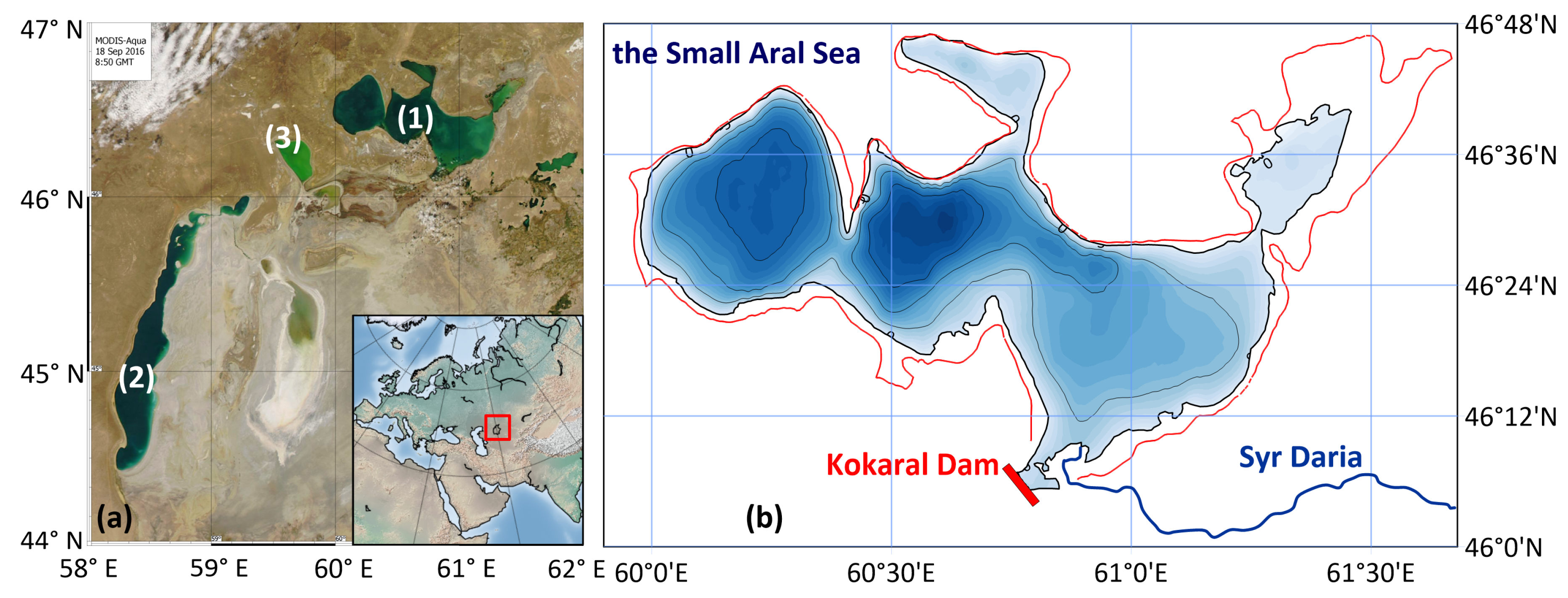
The Aral Sea, an endorheic lake in Central Asia, is known as one of the most dramatic cases of rapid shallowing and degradation of the lake ecosystem, mainly caused by anthropogenic influence on the water balance regime in the basin. Formerly the fourth largest lake on Earth, the Aral Sea has lost more than 90% of its waters since 1961 [9]. In 1989, the northern part of the Aral Sea and the main body of the lake separated, forming two individual lakes known as the North (Small) Aral Sea and the South (Large) Aral Sea [10] (Figure 1). During the subsequent desiccation, the Large Aral Sea lost its permanent connection with the main tributary, Amu Daria. It turned into a hypersaline lake [11,12,13], and, in turn, broke up into several water bodies, connected by seasonal inter-basin water exchange [14]. The Small Aral is connected with the second major tributary of the former Aral, the Syr Darya River. Still, even during periods of high river flow, the lake’s surface level recovery was limited by the overflow toward the Large Aral through the Berg strait. Since the separation of the two lakes, several attempts to build a dam in the strait were observed [15]. Since the construction of the Kokaral dike in its present form in the fall of 2005, the outflow in the direction to the Large Aral through the Berg strait has been regulated [16].
The construction of the Kokaral dam led to the stabilization of the Small Aral Sea water level, a decrease in water salinity, and, as a result, the partial recovery of the biological resources of the lake, including the return of commercial fish fauna [17]. Moreover, the freshened outflow from the Small Aral Sea through the dike is considered one of the major positive components of the water budget of the southern residual basins of the Aral Sea. Variability in this outflow affects not only the volume but also salinity and water geochemistry [18,19,20], vertical mixing [21] and biogeochemical [22] regimes in Lake Chernyshev, Lake Tshchebas and the western basin of the Large Aral Sea. Outflow from the Small Aral Sea can also be addressed as the potential source of pollution [23], incoming to the lake with the Syr Darya inflow. However, even after the man-induced stabilization, the Small Aral Sea remains highly dependent on fluctuations in the water balance components, taking into account high anthropogenic pressure on the Syr Darya watershed and arid climate conditions.
Studies of the modern Aral Sea water balance are mostly based on satellite and indirect data sources due to a lack of regular direct observations of lake water level and components of water balance, which were partly ended in the late 1980s. The summary of the volume variations for the period before the separation of the Small and Large Seas was given by Bortnik and Chistyaeva [24]. Furthermore, in view of the wide distribution of satellite altimetry data, numerous studies focus on the Aral Sea desiccation problem seen from space. Thus, the combination of satellite altimetry and digital bathymetric model was implemented for the water balance study of the Large Aral Sea [25]; volume and surface area of the Aral’s residual basins were estimated using the combined approach of satellite altimetry, digital bathymetry and MODIS images [26]. The total loss of water volume for the residual basins of the Aral Sea was estimated in combination with the water coverage from AVHRR data and the sea levels from altimetry data [27], as well as with the Gravity Recovery and Climate Experiment satellite observations [28,29].
According to the last IPCC report [30], numerous changes in hydrological cycle components, such as precipitation or evaporation dynamics, are induced by ongoing climate change. These changes are expected to affect many vital parts of the natural environment and human lives. Unusual patterns in extreme precipitation, changing longevity and seasonality of floods and droughts as well as melting glaciers may have a pronounced impact on water ecosystems, food and energy production, and society in particular. Thus, the presented study is focused on revealing the Small Aral Sea slow-onset water balance dynamics induced by climate change because it has clear connections to all potentially affected fields mentioned above: from melting glaciers in the Tian Shan mountains to water management in the Syr Darya River valley to ecosystem production in the Small Aral Sea.
Despite an impressive number of articles and methods devoted to studying the occurred water volume changes in the Aral Sea, the question of how the lake system will behave in the future remains insufficiently studied. As for the human-regulated reservoir, the problem is important for the Small Aral Sea, especially considering the ongoing variations of the river inflow. Hence, the presented study is focused on the modern dynamics of the Small Aral Sea water balance and its projections depending on climate change scenarios. We attempt to answer the following questions: firstly, how are the dynamics of the components of the water balance arranged in the present-day Small Aral Sea, and secondly, what will be the response of the lake’s water balance system to projected climate changes? Accordingly, here we present the water balance model for the Small Aral Sea developed with monthly time resolution, validate the model on the historical data period and simulate the lake water balance depending on the climatic projections. The novelty of this study is ensured by using the latest high-resolution data on water balance parameters and climatic forcing along with considering scenarios of possible restructuring of the artificial dam level. The obtained results will interest a wide range of specialists, especially considering the existing ideas on the possibility of recovering the Aral Sea.
2. Materials and Methods
2.1. Input Data
The following subsection gives a detailed description of the data used in the water balance model.
In the present study, we use global gridded meteorological data distributed in the framework of the ISIMIP project [31] as the atmospheric forcing conditions. Estimates of precipitation and air temperature data for the historical period (1979–2016) are obtained from the EWEMBI (EartH2Observe, WFDEI and ERA-Interim data Merged and Bias-corrected for ISIMIP) dataset [32,33,34]. For the projected period (2017–2099), we use EWEMBI-RCP data that are compiled from the outputs of four General Circulation Models (GCMs: GFDL-ESM2M, HadGEM2-ES, IPSL-CM5A-LR, MIROC5) under three representative concentration pathway (RCPs: RCP2.6, RCP6.0, RCP8.5) scenarios. Both datasets have global coverage, daily temporal resolution, 0.5° × 0.5° spatial resolution and have undergone comprehensive bias-correction and statistical downscaling procedures. Reference evaporation was calculated using a temperature-based equation proposed by Oudin et al. [35] using air temperature data for both historical and projection periods based on EWEMBI and EWEMBI RCP data, respectively.
While there are many meteorological data products and related methods to represent hydrological cycle processes on finer spatial resolution, they introduce an additional source of uncertainty in an already complex modeling system [36,37,38]. Thus, using community-approved, spatially, and temporally consistent and coherent datasets—EWEMBI and EWEMBI RCP—provides a robust solution for developing reliable modeling chains. The EWEMBI and EWEMBI-RCP datasets have been used as a reliable source of meteorological forcing data for many scientific studies [39,40,41,42].
The main part of the incoming water balance—the river runoff entering the lake—was calculated using the hybrid model of water runoff formation and transformation in the Small Aral Sea basin [41,43]. The underlying hybrid model comprises two components: (1) a module for physically-based runoff generation in mountainous areas where the water management is minor and (2) a machine learning-based runoff transformation routine that helps to propagate natural runoff through the complicated water management system in the Syr Darya River valley. The first model component utilizes the HBV (Hydrologiska Byråns Vattenbalansavdelning) hydrological model [44,45] that calculates daily runoff based on the input time series of precipitation, air temperature, and potential evapotranspiration obtained from the EWEMBI reanalysis data and EWEMBI RCP scenarios. Then, daily runoff is aggregated to monthly values and propagated as input to the second model component—a machine learning model based on the eXtreme Gradient Boosting machine on decision trees (XGB) [46]—that mimics the behavior of a water management system. The final model output—monthly values of the Syr Darya River runoff entering the sea during the historical period, as well as its future projections—is then utilized as a component of the incoming part of the Small Aral Sea water balance. Model validation results confirm its high efficiency and reliability in the historical period [41]. Hence, the developed model could be reliably used for calculating future projections of Syr Darya River runoff. A detailed description of runoff formation and transformation model components and their validation can be found in [41].
Unfortunately, there are no reliable data on the inter-annual variations of the groundwater component of the water balance for the Small Aral Sea. However, most researchers agree that groundwater inflow, infiltration, and mutual compensation have no significant effect on the lake water balance [24,47]. Therefore, the underground component was not considered in the model.
2.2. Model Setup
For the enclosed Small Aral Sea, which is characterized by significant changes in surface area and water volume, it is most indicative to calculate the lake’s water balance in linear units—volume increment in our case. The model was configured with monthly time step, so the volume increment on step i was written as follows:
where (km3) is the river inflow, (km3)—atmospheric precipitation, (km3)—evaporation, (km3)—discharge through the dike gate and (km3) is volume increment within the 1 month period of calculation.
The outflow from the lake D through the Kokaral Dam is an important negative component of the regulated lake (reservoir) water balance. After its separation, the Small Aral Sea remained connected with the main part of the former Aral bed through the natural Berg strait. Due to existing topographic characteristics, the water flow through the strait was directed from the Small Aral Sea to the remaining southern part, which resulted in a decrease in the Small Aral level in the 1990s and early 2000s. The construction of the Kokaral Dam in this natural strait has only increased the elevation of the Small Aral Sea surface level. Thus, in the seasonally driven periods of high water, when the surface level of the Small Aral Sea reaches the dam limits, the clearly shown outflow from the lake exists. The presented water balance model considers the period since 2006 when the present-day version of the Kokaral dam was launched. However, no directly observed data about the amount of discharge through the dam are available.
To consider the outflow through the dam in the model, a threshold value of water volume km3 was used. That volume corresponds to a surface lake level benchmark of 42.5 m.a.s.l. set up by the dam. The model assumes that water volume excess over this benchmark at the previous step discharges through the dam at the beginning of the next calculation step.
Accordingly, if
then,
and
Otherwise, if
then, and
On each calculation step, monthly values of and are calculated according to evaporation and precipitation taken from the EWEMBI and EWEMBI RCP datasets multiplied by the lake surface area, corresponding to the current volume of water .
Overall, three series of model experiments were performed: (i) validation period (2006–2017), (ii) projected period (2008–2099) under three representative concentration pathway scenarios at the existing Kokaral dam height, i.e., 42.5 m.a.s.l., and (iii) projected period (2008–2099) under three representative concentration pathway scenarios at increased dam height, i.e., 46.5 m.a.s.l. For the increased dam conditions, the water volume threshold value km3 was used according to obtained hypsometric relation (see below).
2.3. Model Validation
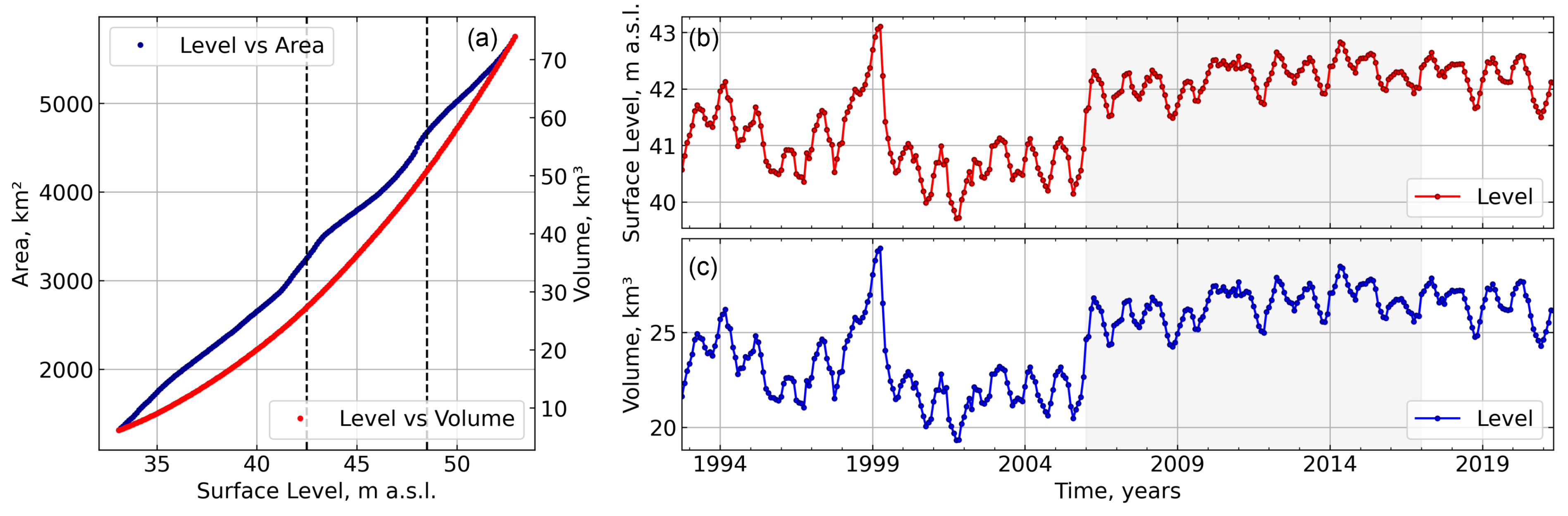
To connect the lake’s surface level, area and volume, we used the digital bathymetry map of the Aral Sea. The bathymetry of the Small Aral Sea part, defined as the area to the north from 46 N latitude and consisting of 300 × 102 nodes, was cut out from the map. The horizontal dimensions of the map were recalculated from degrees to the metric system as follows: the length of one degree in longitude is 76.6 km, and one degree in latitude is 111.14 km. The obtained bathymetry map represented the depths of the Small Aral Sea for the value of 53 m.a.s.l., i.e., the mean annual value of the lake surface before the beginning of the desiccation in the 1960s. Values of water volume and surface area of the lake were calculated based on the obtained bathymetry map with a 0.1 m step from 53 m.a.s.l to 33 a.s.l. using the Volume script of Golden Software Surfer 15 to obtain the lake hypsometric relation. Satellite altimetry-based data on the Small Aral Sea surface level variability were taken from the Hydroweb project [48] with 10 days of temporal resolution. They were used to calculate the “observed” monthly values of water volume and surface area for the Small Aral Sea during the validation period (2006–2017) (Figure 2). Finally, the water balance model results were validated during that period.
3. Results
3.1. Current Water Balance Dynamics
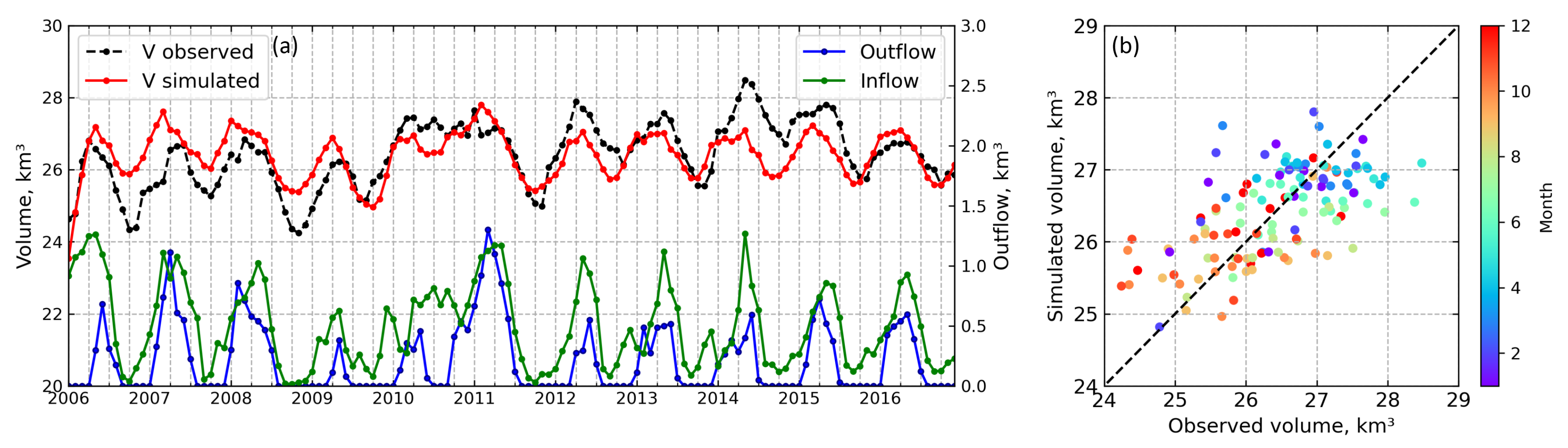
The simulated water balance dynamics on the historical period of 2006–2017 showed the variability of Small Aral Sea water volume monthly values in the range from 23.7 km to 28.4 km with a mean value of 26.4 km (Figure 3). The simulated mean and maximum values agreed with the observed values of 28.5 km and 26.4 km, respectively, within the same period. However, the observed minimum value of 24.2 km3 was 0.5 km higher than the simulated minimum result. Mean annual river inflow during the historical period was estimated as 6 km3 varying from 4.3 km3 to 8.5 km. The model estimation of the Kokaral outflow mean annual value was 2.5 km3 varying from 0.3 km3 to 5.3 km3.
3.2. Water Balance Projections with the Present Lake Surface Height
To assess the impact of possible climate changes on the dynamics of the Small Aral Sea water balance, we considered below three possible scenarios of atmospheric forcing and river inflow (RCP 2.6, RCP 6.0 and RCP 8.5). Each represented the mean values of model experiments based on four models of climatic forcing (GFDL-ESM2M, HadGEM2-ES, IPSL-CM5A-LR, MIROC5). Separately, the results of the most unfavorable scenario regarding the lake volume are given. The mean modelling results within the RCP 2.6 and RCP 6.0 scenarios showed the possibility of maintaining the Small Aral Sea volume within annual values from 26 to 27 km3until the end of the century (Figure 4), i.e., at the present-day state. However, since 2060, the dispersion of modeling results within these scenarios has increased, and the standard deviation values reached 1 km3. The mean modeling results under the RCP 8.5 scenario showed the decrease in the lake volume below 26 km during the last 2 decades of the 21st century. At the same time, model calculations within this scenario were characterized by greater uncertainty, i.e., 1.5 km, depending on the atmospheric forcing model used. Thus, in the most unfavorable case of IPSL-CM5A-LR RCP 8.5, the volume of water revealed a downward trend from the end of the 2030s, along with a rapid decrease down to 24 km since the end of the 2070s. The volume decrease under this scenario was also accompanied by a gradual decrease in the amount of the Kokaral outflow (Figure 4).
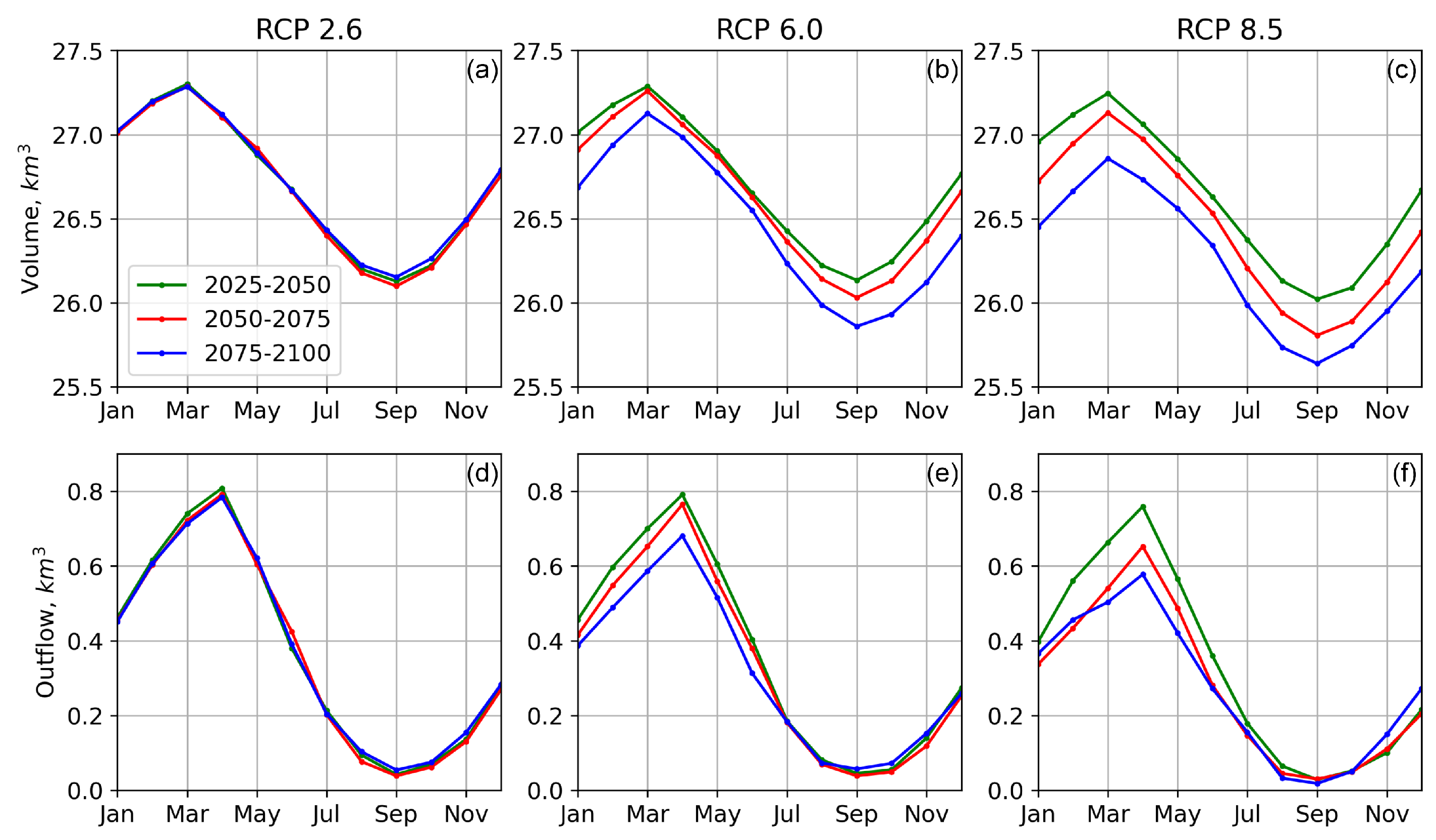
Figure 5 shows inter-annual fluctuations of water volume and outflow from the dam, averaged for the periods of the second, third and fourth quarters of the 21st century, depending on the climatic scenarios. Under the RCP 2.6 scenario, the mean annual volume of the lake reached 26.7 km with the mean annual outflow of 4.4 km year without significant changes between selected quarters. Similar values of the mean annual lake volume and mean annual outflow were simulated in the second quarter of the century under the RCP 6.0 scenario. However, a decrease to 26.5 km for mean annual volume and 3.8 km year for mean annual outflow were simulated for the fourth quarter of the century. The mean annual water volume and outflow decline were revealed most clearly in the RCP 8.5 scenario. Thus, the mean volume in the third and fourth quarter of the century reached 26.6 km and 26.2 km, respectively, while the mean annual outflow reached 3.9 km year and 3.2 km year, respectively.
3.3. Water Balance Projections with the Increased Lake Surface Height
To assess the impact of possible abrupt anthropogenic influence on the lake state along with the projected climate change, we investigated the water balance dynamics in the case of increased level of the lake surface. Figure 6 shows projections of the Small Aral Sea water volume variability with increased surface level up to 48.5 m.a.s.l., i.e., 6 m higher than at the present state. In each of the three RCP scenarios, water volume reached the maximum possible mean annual values of 49.5 km, determined by the new dam height within less than 10 years (since 2008 as the start date of simulations to 2014–2017). Since 2025, according to the mean model estimates under the RCP 2.6 scenario, preservation of the lake water volume will be possible until the end of the century with a mean annual water volume of 48.2 km and a mean annual outflow of 3 km year(Figure 7).
The mean modeling results under the RCP 6.0 scenario revealed more pronounced interannual fluctuations of water volume and its gradual decrease from the end of the 2060s to the values of about 45 km by the end of the century. Mean annual water volume and outflow reached 49.1 km and 2.9 km year, respectively, during the second quarter, 48.8 km and 2.6 km year during the third quarter, 46.5 km and 2.5 km year during the fourth quarter (Figure 7).
The mean model estimates under the RCP 8.5 scenario demonstrated a gradual decrease in mean annual water volume, namely from the beginning of the decade of the 2060s, to the value of 41.7 km by the end of the century (Figure 7). This decrease was also accompanied by changes in the mean outflow, which reached mean annual values of 0.7–1.1 km year by the end of the century. Inter-decade variability was also well shown. Thus, the mean water volume and mean outflow reached 48.8 km and 2.5 km year, respectively, in the second quarter of the century, 47.3 km and 1.9 km year in the third quarter of the century, 44.8 km and 1.9 km year in the fourth quarter of the century (Figure 7).
The worst-case scenario, according to the RCP 8.5 IPSL-CM5A-LR climatic forcing, showed a gradual decrease in water volume down to 28.4 km by the end of the century, which is very close to the water volume at the present-day Kokaral dam level, with complete absence of water outflow from 2040 to the end of the century (Figure 6).
4. Discussion
The presented water balance model made it possible to reproduce the variability of water volume over the historical period from 2006 to 2017 and estimate the monthly volume of water discharged from the Kokaral dam. The existing deviations of the modeled values of water volume in the Small Aral Sea from the observational data obtained using the bathymetry model and satellite altimetry mainly resulted from the unstable regime of water release from the dam. In contrast, in the model, a strict condition for the start of the water release was set. Thus, the model overestimates the volume of the Small Aral Sea from 2006 to 2010 and underestimates the lake’s volume from 2012 to 2016. During the highest values of the river inflow to the lake from 2010 to 2012, the model most accurately fits the observations.
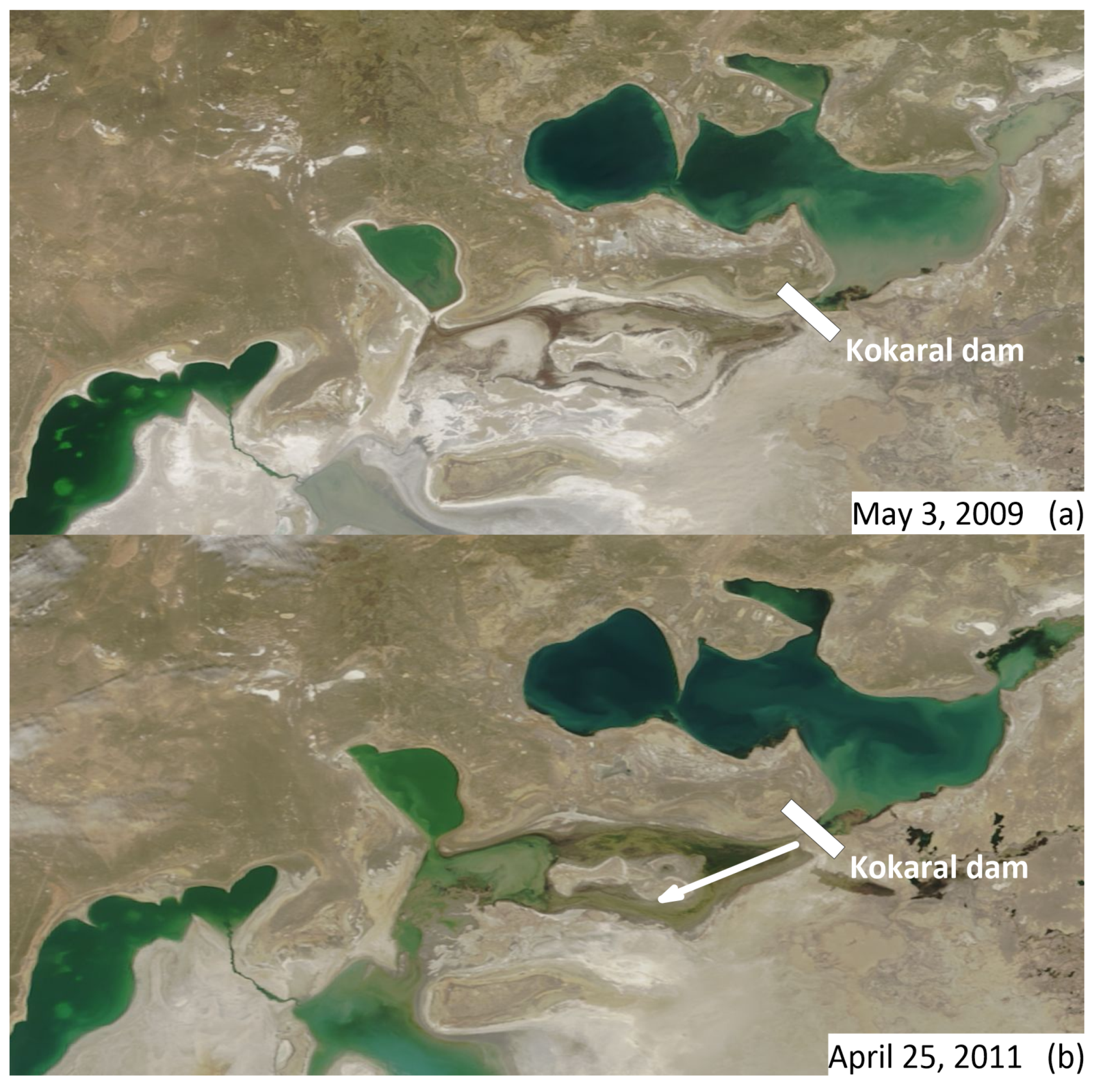
In view of the absence of regular observational data on the Kokaral dam outflow, obtained modeled monthly values allow for estimating which part of water flowing into the lake remains in the sea and which part goes further downstream. According to obtained estimations, during the model validation period after the launch of the Kokaral dam, the mean annual inflow to the Small Aral Sea was 6 km year. Such amount of inflow makes it possible to provide recovery of the Small Aral Sea within the projected height of the dam and gives a mean annual outflow of 2.5 km year, which should be considered as the most important positive component of the water balance of the southern part of the Aral Sea. Meanwhile, the significant inter-annual variability of the Kokaral outflow was observed during the validation period. During the periods of maximum inflow of the Syr Darya River to the Small Aral, when the surface of the Small Aral Sea reached its maximum in 2010–2011, the annual outflow from the dam increased to 3.4–5.3 km year accordingly. These amounts of discharge, along with the increased inflow of the Amu Daria River in the southern part, caused the cessation of decreasing and even raised the surface level of the Large Aral, that was found out by satellite altimetry data [49] and images (Figure 8), where the influence of the discharge from the Small Aral is clearly shown.
Projected estimates of the volume variability of the Small Aral Sea under the RCP 2.6 and RCP 6.0 scenarios showed the possibility of retaining the relatively stable lake level with inter-decade outflow fluctuations. On the contrary, projected estimates under the RCP 8.5 scenario showed the most well-shown instability of the lake volume with a declining trend toward the end of the century (Figure 4 and Figure 5). We considered the river inflow and evaporation minus precipitation variations under this scenario to obtain insight into the projected changes (Figure 9a). The entire projection period can be divided into time intervals when the annual values of water volume were above or equal to 26.5 km, i.e., “stable” surface-level conditions, and below 26.5 km, i.e., “unstable” surface-level conditions. Accordingly, the lake volume remained mainly stable before 2055, while unstable conditions during that period only referred to local drops of annual river inflow values accompanied by local evaporation increases. However, annual values of the lake volume were mainly unstable after 2055 toward the end of the century due to the joint effect of a general downward trend of the river inflow and a general upward trend in evaporation minus precipitation. Hence, the stability of the lake volume was defined by the annual balance between river inflow values and values of evaporation minus precipitation.
Similarly, we analyze the projected estimates of water volume variability of the Small Aral Sea in the case of increased dam conditions under the RCP 8.5 scenario. The entire projected period can be divided into time intervals when the annual values of water volume were above or equal to 48 km, i.e., “stable” surface-level conditions, and below 48 km, i.e., “decreasing” level conditions (Figure 9b). The benchmark of 48 km was used due to the well-shown inter-annual variability above this value, while the drop in the volume below this mark was followed by its constant decrease, as shown above in Figure 6. At the beginning of the projected period (2008–2015), the lake was filling up, so the annual volume was below 48 km. This filling was accompanied by an increase in the lake area and a sharp increase in evaporation. Since 2015, the lake volume annual values have reached stable conditions with an episodic decrease in 2047–2049. Subsequently, the lake began to shrink since 2058 toward the end of the century due to a gradual increase in evaporation and a decrease in river inflow.
Water balance conditions, projected under the RCP 8.5 scenario, are apparently the most representative case of the Small Aral Sea response to climatic and anthropogenic forcing. Implying the most stressing influence in terms of evaporation and river inflow, among other scenarios, the RCP 8.5 projection still allows for estimating the water balance conditions representing the stable or unstable state of the lake volume in the most adverse case. A summary of the input inflow and evaporation minus precipitation conditions, as well as the simulated results, including the volume stability and outflow, is given in Table 1. The obtained assessments of the water balance conditions can be considered in the context of managing the region’s water resources or carrying out work to change the dam’s height, which regulates the outflow from the Small Aral Sea.
Previous studies reported the possibility of maintaining the surface of the Small Aral Sea at increased benchmark of 48 m.a.s.l. by ensuring the minimum average annual flow of the Syr Darya River of 5.31–5.96 km year, based on the average annual values of the water balance parameters during the historical period from 1992 to 2011 [50]. However, taking into account climate-induced future changes in the river inflow, evaporation and precipitation, the presented study shows that the ensuring of even higher inflow values of 7–7.1 km year may not provide a stable level position at these benchmarks according to considered long-term climatic scenarios. The proposed water balance model has a monthly resolution and makes it possible to take into account the high seasonal variability of the water balance parameters. The maximum values of the inflow are observed in the spring period, which ensures the maximum water outflow. At the same time, high evaporation rates occur in summer and early autumn accompanied by minimal river inflow. Thus, considering seasonal dynamics contributes to a more accurate forecasting compared to operating with average annual values.
The limitations of the proposed approach are determined by the consideration of the simulated river inflow based on the current water resources management strategy in the upstream parts of the Syr Darya basin. The inflow to the Small Aral represents the final point of water accumulation in the catchment area and, therefore, any possible changes in water management in the upstream system of the Syr Darya reservoirs during the projected period will cause corresponding responses in the inflow, which are not considered by the presented water balance model. Additionally, given the projected estimates of the Small Aral Sea, water cycle dynamics are affected by the uncertainty of the climatic scenarios. Hence, the widespread introduction of regular instrumental observations on the standard hydro-meteorological and water balance parameters should be provided at the lake. On this basis, the validation of projected climate forcing and lake response should be performed before making decisions on increasing the existing dam benchmark.
The variability of water balance conditions and possible man-induced dam height adjustments may result in fluctuations in the lake surface level, volume and outflow conditions, as well as in the hydrophysical regime of the lake itself. On the one hand, possible changes in the lake depth along with observed worldwide lake response to climatic changes [2,8,51] could result in the transformation of vertical mixing regime, affecting, in turn, the oxygen regime [52] and methane formation [22] in the Small Aral Sea. On the other hand, changes in water volume after the Kokaral dam implementation have already caused the decrease in terms of lake mineralization [14,16,20] and, thereafter, transformations of biological communities [53,54,55,56], including restoration of fish population [17]. Additionally, situated in the lowest part of the local flow system, the Small Aral Sea is supposed to accumulate permanent groundwater discharge [57], and, thereby, the lake level variability could affect the position of groundwater horizon, used by the population of the surrounding settlements, which is a critical issue for living in the arid region. Finally, the Syr Daria inflow is the major source of pollution load to the Small Aral Sea [23,58] and potential changes in the Kokaral outflow could affect the character of pollution transport to the downstream areas.
5. Conclusions
The regime of inland waters in the endorheic basins of the arid zone is especially vulnerable to climate-induced changes and anthropogenic influence in their water balance system. The Small Aral Sea suffered a drastic shrinkage since the 1960s and partially recovered in 2006 with the launch of the Kokaral dam. The lake is currently the subject of significant inter-annual variability of its water volume due to varying river inflow and ongoing climatic changes. This study suggests a water balance model of the Small Aral Sea considering the Syr Darya inflow, evaporation, precipitation and water outflow from the dam. The model was implemented with a monthly resolution. Model validation was carried out based on satellite altimetry data on the variability of the lake surface level. The model allows for the investigation of the current dynamics of the Small Aral Sea water balance components as well as to assess the changes that could occur with the water balance of the lake, depending on the three climatic scenarios (representative concentration pathways) by 2099 and two cases of the regulation of the Kokaral dam height: the present-day conditions (42.5 m.a.s.l.) and increased lake surface (48.5 m.a.s.l.).
The presented water balance model made it possible to reproduce the outflow from the Kokaral dam over the modern period from 2006 to 2017, which reached a mean annual value of 2.5 km year, with a maximum value of 5.3 km year, which resulted in a cessation of the surface level decreasing the Large Aral Sea in 2010–2011. The projected mean estimations in the case of the present-day dam conditions showed the possibility of retaining the lake volume above 26 km toward the end of the century under the RCP 2.6 and 6.0n scenarios. Increased evaporation and lower amounts of river inflow under the RCP 8.5 scenario caused the significant instability of the lake volume in the second half of the 21st century with annual water volume values below 26 km and a well-shown decrease in the outflow amount.
A possible human-made increase in the lake surface level up to 48.5 m.a.s.l., maintained by the new dam, may participate to the filling of the volume of the Small Aral Sea and its retaining in the range of 48–50 km under the RCP 2.6 scenario during the 21st century. Simulation under the RCP 6.0 scenario revealed a possible lake volume decrease to 45 km from the 2080s. In contrast, simulations under the RCP 8.5 scenario showed the gradual decrease in the lake volume to 42 km from 2055 with almost full cessation of the Kokaral outflow.
Estimated possible changes in the Small Aral Sea volume and amounts of Kokaral outflow may affect not only the water balance conditions of the other residual Aral Sea basins but also the hydrophysical state and ecology of the Small Aral itself, which should be taken into account during the water management activities in the region.
Author Contributions
Conceptualization, A.I. and G.A.; methodology, A.I. and G.A.; software, A.I.; validation, A.I.; formal analysis, A.I.; investigation, A.I.; writing—original draft preparation, A.I.; writing—review and editing, A.I. and G.A.; visualization, A.I.; funding acquisition, A.I. and G.A. All authors have read and agreed to the published version of the manuscript.
Funding
This study was supported by the Russian Science Foundation, Project No. 21-77-00088, (data processing, visualization and analysis), Ministry of Science and Higher Education of the Russian Federation, Theme FMWE-2021-0001 (bathymetry model design and calculations). G.A. is supported by the Inno_MAUS project. The Federal Ministry of Education and Research (BMBF) is funding the Inno_MAUS project within the “Wasser-Extremereignisse” (WaX) funding measure as part of the federal research program on water “Wasser: N”. “Wasser: N” contributes to the BMBF “Research for Sustainability’ (FONA) Strategy”.
Institutional Review Board Statement
Not applicable.
Informed Consent Statement
Not applicable.
Data Availability Statement
The data presented in this study are available upon request from the corresponding author.
Acknowledgments
The authors thank Abilgazy K. Kurbaniyazov for their assistance in collecting input information for the study.
Conflicts of Interest
The authors declare no conflict of interest.
References
- Adrian, R.; O’Reilly, C.M.; Zagarese, H.; Baines, S.B.; Hessen, D.O.; Keller, W.; Livingstone, D.M.; Sommaruga, R.; Straile, D.; Van Donk, E.; et al. Lakes as sentinels of climate change. Limnol. Oceanogr. 2009, 54, 2283–2297. [Google Scholar]
- Woolway, R.I.; Merchant, C.J. Worldwide alteration of lake mixing regimes in response to climate change. Nat. Geosci. 2019, 12, 271–276. [Google Scholar]
- Stefanidis, P.; Stefanidis, S.; Tziaftani, F. The threat of alluviation of lakes resulting from torrents (case study: Lake Volvi, north Greece). Int. J. Sustain. Dev. Plan. 2011, 6, 325–335. [Google Scholar]
- Myronidis, D.; Stathis, D.; Ioannou, K.; Fotakis, D. An integration of statistics temporal methods to track the effect of drought in a shallow Mediterranean Lake. Water Resour. Manag. 2012, 26, 4587–4605. [Google Scholar]
- Bai, J.; Chen, X.; Li, J.; Yang, L.; Fang, H. Changes in the area of inland lakes in arid regions of central Asia during the past 30 years. Environ. Monit. Assess. 2011, 178, 247–256. [Google Scholar]
- Wurtsbaugh, W.A.; Miller, C.; Null, S.E.; DeRose, R.J.; Wilcock, P.; Hahnenberger, M.; Howe, F.; Moore, J. Decline of the world’s saline lakes. Nat. Geosci. 2017, 10, 816–821. [Google Scholar]
- Wang, J.; Song, C.; Reager, J.T.; Yao, F.; Famiglietti, J.S.; Sheng, Y.; MacDonald, G.M.; Brun, F.; Schmied, H.M.; Marston, R.A.; et al. Recent global decline in endorheic basin water storages. Nat. Geosci. 2018, 11, 926–932. [Google Scholar]
- Zhang, X.; Kurbaniyazov, A.; Kirillin, G. Changing Pattern of Water Level Trends in Eurasian Endorheic Lakes as a Response to the Recent Climate Variability. Remote Sens. 2021, 13, 3705. [Google Scholar]
- Zavialov, P.; Arashkevich, A.; Bastida, I.; Ginzburg, A.; Dikarev, S.; Zhitina, L.; Izhitsky, A.; Ishniyazov, D.; Kostyanoy, A.; Kravtsova, V.; et al. The Large Aral Sea in the Beginning of Century 21: Physics, Biology, Chemistry; Nauka: Moscow, Russia, 2012. [Google Scholar]
- Zavialov, P.O.; Kostianoy, A.G.; Emelianov, S.V.; Ni, A.A.; Ishniyazov, D.; Khan, V.M.; Kudyshkin, T.V. Hydrographic survey in the dying Aral Sea. Geophys. Res. Lett. 2003, 30, 1659. [Google Scholar] [CrossRef]
- Zavialov, P.O. Physical Oceanography of the Dying Aral Sea; Springer: Berlin/Heidelberg, Germany, 2007. [Google Scholar]
- Izhitskiy, A.; Zavialov, P.O.; Roget, E.; Huang, H.P.; Kurbaniyazov, A.K. On thermohaline structure and circulation of the Western Large Aral Sea from 2009 to 2011: Observations and modeling. J. Mar. Syst. 2014, 129, 234–247. [Google Scholar]
- Izhitskiy, A.; Khymchenko, E.; Zavialov, P.; Serebryany, A. Hydrophysical state of the Large Aral Sea in the autumn of 2013: Thermal structure, currents, and internal waves. Oceanology 2014, 54, 414–425. [Google Scholar]
- Izhitskiy, A.; Zavialov, P.; Sapozhnikov, P.; Kirillin, G.; Grossart, H.; Kalinina, O.; Zalota, A.; Goncharenko, I.; Kurbaniyazov, A. Present state of the Aral Sea: Diverging physical and biological characteristics of the residual basins. Sci. Rep. 2016, 6, 23906. [Google Scholar]
- Aladin, N.; Crétaux, J.F.; Plotnikov, I.S.; Kouraev, A.V.; Smurov, A.O.; Cazenave, A.; Egorov, A.N.; Papa, F. Modern hydro-biological state of the Small Aral sea. Environmetrics 2005, 16, 375–392. [Google Scholar] [CrossRef] [Green Version]
- Aladin, N.V.; Plotnikov, I.S.; Micklin, P.; Ballatore, T. Aral Sea: Water level, salinity and long-term changes in biological communities of an endangered ecosystem-past, present and future. Nat. Resour. Environ. Issues 2009, 15, 36. [Google Scholar]
- Ermakhanov, Z.K.; Plotnikov, I.S.; Aladin, N.V.; Micklin, P. Changes in the Aral Sea ichthyofauna and fishery during the period of ecological crisis. Lakes Reserv. Sci. Policy Manag. Sustain. Use 2012, 17, 3–9. [Google Scholar] [CrossRef]
- Pokrovsky, B.; Zaviyalov, P.; Bujakaite, M.; Izhitskiy, A.; Petrov, O.; Kurbaniyazov, A.; Shimanovich, V. Geochemistry of O, H, C, S, and Sr Isotopes in the Water and Sediments of the Aral Basin. Geochem. Int. 2017, 55, 1033–1045. [Google Scholar]
- Andrulionis, N.Y.; Zavialov, P.O.; Izhitskiy, A.S. Current Evolution of the Salt Composition of Waters in the Western Basin of the South Aral Sea. Oceanology 2021, 61, 899–908. [Google Scholar] [CrossRef]
- Andrulionis, N.Y.; Zavialov, P.O.; Izhitskiy, A.S. Modern Evolution of the Salt Composition of the Residual Basins of the Aral Sea. Oceanology 2022, 62, 30–45. [Google Scholar] [CrossRef]
- Izhitskiy, A.S.; Kirillin, G.B.; Goncharenko, I.V.; Kurbaniyazov, A.K.; Zavialov, P.O. The world’s largest heliothermal lake newly formed in the Aral Sea basin. Environ. Res. Lett. 2021, 16, 115009. [Google Scholar]
- Izhitskaya, E.; Egorov, A.; Zavialov, P.; Yakushev, E.; Izhitskiy, A. Dissolved methane in the residual basins of the Aral Sea. Environ. Res. Lett. 2019, 14, 065005. [Google Scholar]
- Rzymski, P.; Klimaszyk, P.; Niedzielski, P.; Marszelewski, W.; Borowiak, D.; Nowiński, K.; Baikenzheyeva, A.; Kurmanbayev, R.; Aladin, N. Pollution with trace elements and rare-earth metals in the lower course of Syr Darya River and Small Aral Sea, Kazakhstan. Chemosphere 2019, 234, 81–88. [Google Scholar] [CrossRef]
- Bortnik, V.; Chistyaeva, S. Hydrometeorology and Hydrochemistry of the USSR Seas. Volume VII. The Aral Sea; Gidrometeoizdat: Leningrad, Russia, 1990; p. 196. [Google Scholar]
- Crétaux, J.F.; Kouraev, A.V.; Papa, F.; Bergé-Nguyen, M.; Cazenave, A.; Aladin, N.; Plotnikov, I.S. Evolution of sea level of the big Aral Sea from satellite altimetry and its implications for water balance. J. Great Lakes Res. 2005, 31, 520–534. [Google Scholar]
- Cretaux, J.F.; Kostianoy, A.; Bergé-Nguyen, M.; Kouraev, A. Present-day water balance of the Aral Sea seen from satellite. In Remote Sensing of the Asian Seas; Springer: Berlin/Heidelberg, Germany, 2019; pp. 523–539. [Google Scholar]
- Shi, W.; Wang, M.; Guo, W. Long-term hydrological changes of the Aral Sea observed by satellites. J. Geophys. Res. Ocean. 2014, 119, 3313–3326. [Google Scholar]
- Singh, A.; Seitz, F.; Schwatke, C. Inter-annual water storage changes in the Aral Sea from multi-mission satellite altimetry, optical remote sensing, and GRACE satellite gravimetry. Remote Sens. Environ. 2012, 123, 187–195. [Google Scholar]
- Tao, D.; Shi, H.; Gao, C.; Zhan, J.; Ke, X. Water storage monitoring in the Aral Sea and its Endorheic Basin from multisatellite data and a hydrological model. Remote Sens. 2020, 12, 2408. [Google Scholar]
- Pörtner, H.O.; Roberts, D.C.; Adams, H.; Adler, C.; Aldunce, P.; Ali, E.; Begum, R.A.; Betts, R.; Kerr, R.B.; Biesbroek, R.; et al. Climate Change 2022: Impacts, Adaptation and Vulnerability; IPCC: Geneva, Switzerland, 2022. [Google Scholar]
- Frieler, K.; Lange, S.; Piontek, F.; Reyer, C.P.O.; Schewe, J.; Warszawski, L.; Zhao, F.; Chini, L.; Denvil, S.; Emanuel, K.; et al. Assessing the impacts of 1.5 ∘C global warming—simulation protocol of the Inter-Sectoral Impact Model Intercomparison Project (ISIMIP2b). Geosci. Model Dev. 2017, 10, 4321–4345. [Google Scholar] [CrossRef] [Green Version]
- Lange, S. Bias correction of surface downwelling longwave and shortwave radiation for the EWEMBI dataset. Earth Syst. Dyn. 2018, 9, 627–645. [Google Scholar] [CrossRef] [Green Version]
- Lange, S. Trend-preserving bias adjustment and statistical downscaling with ISIMIP3BASD (v1.0). Geosci. Model Dev. 2019, 12, 3055–3070. [Google Scholar] [CrossRef] [Green Version]
- Lange, S. EartH2Observe, WFDEI and ERA-Interim Data Merged and Bias-Corrected for ISIMIP (EWEMBI). V. 1.1. GFZ Data Services. 2019. Available online: https://dataservices.gfz-potsdam.de/pik/showshort.php?id=escidoc:3928916 (accessed on 8 April 2023).
- Oudin, L.; Hervieu, F.; Michel, C.; Perrin, C.; Andréassian, V.; Anctil, F.; Loumagne, C. Which potential evapotranspiration input for a lumped rainfall–runoff model? Part 2—Towards a simple and efficient potential evapotranspiration model for rainfall–runoff modelling. J. Hydrol. 2005, 303, 290–306. [Google Scholar] [CrossRef]
- Chen, H.; Xu, C.Y.; Guo, S. Comparison and evaluation of multiple GCMs, statistical downscaling and hydrological models in the study of climate change impacts on runoff. J. Hydrol. 2012, 434–435, 36–45. [Google Scholar] [CrossRef]
- Maraun, D.; Wetterhall, F.; Ireson, A.M.; Chandler, R.E.; Kendon, E.J.; Widmann, M.; Brienen, S.; Rust, H.W.; Sauter, T.; Themeßl, M.; et al. Precipitation downscaling under climate change: Recent developments to bridge the gap between dynamical models and the end user. Rev. Geophys. 2010, 48. [Google Scholar] [CrossRef] [Green Version]
- Stefanidis, S. Ability of different spatial resolution regional climate model to simulate air temperature in a forest ecosystem of central Greece. J. Environ. Prot. Ecol. 2021, 22, 1488–1495. [Google Scholar]
- Gelfan, A.; Kalugin, A.; Krylenko, I.; Nasonova, O.; Gusev, Y.; Kovalev, E. Does a successful comprehensive evaluation increase confidence in a hydrological model intended for climate impact assessment? Clim. Chang. 2020, 163, 1165–1185. [Google Scholar] [CrossRef]
- Döll, P.; Trautmann, T.; Gerten, D.; Schmied, H.M.; Ostberg, S.; Saaed, F.; Schleussner, C.F. Risks for the global freshwater system at 1.5 ∘C and 2 ∘C global warming. Environ. Res. Lett. 2018, 13, 044038. [Google Scholar] [CrossRef]
- Ayzel, G.; Izhitskiy, A. Climate change impact assessment on freshwater inflow into the Small Aral Sea. Water 2019, 11, 2377. [Google Scholar]
- Ayzel, G. Runoff for Russia (RFR v1.0): The Large-Sample Dataset of Simulated Runoff and Its Characteristics. Data 2023, 8, 31. [Google Scholar] [CrossRef]
- Ayzel, G.; Izhitskiy, A. Coupling physically based and data-driven models for assessing freshwater inflow into the Small Aral Sea. Proc. Int. Assoc. Hydrol. Sci. 2018, 379, 151–158. [Google Scholar]
- Bergström, S.; Forsman, A. Development of a conceptual deterministic rainfall-runoff model. Hydrol. Res. 1973, 4, 147–170. [Google Scholar] [CrossRef]
- Lindström, G. A simple automatic calibration routine for the HBV model. Hydrol. Res. 1997, 28, 153–168. [Google Scholar]
- Chen, T.; Guestrin, C. Xgboost: A scalable tree boosting system. In Proceedings of the 22nd ACM SIGKDD International Conference on Knowledge Discovery and Data Mining, San Francisco, CA, USA, 13–17 August 2016; pp. 785–794. [Google Scholar] [CrossRef] [Green Version]
- Cretaux, J.F.; Letolle, R.; Bergé-Nguyen, M. History of Aral Sea level variability and current scientific debates. Glob. Planet. Chang. 2013, 110, 99–113. [Google Scholar]
- Crétaux, J.F.; Arsen, A.; Calmant, S.; Kouraev, A.; Vuglinski, V.; Bergé-Nguyen, M.; Gennero, M.C.; Nino, F.; Rio, R.A.D.; Cazenave, A.; et al. SOLS: A lake database to monitor in the Near Real Time water level and storage variations from remote sensing data. Adv. Space Res. 2011, 47, 1497–1507. [Google Scholar] [CrossRef]
- Ginzburg, A.; Kostianoy, A.; Sheremet, N.; Izhitskiy, A.; Soloviov, D. The drying dynamics of the Western Large Aral Sea from satellite data (2002–2021). Sovrem. Probl. Distantsionnogo Zondirovaniya Zemli Kosmosa 2022, 19, 246–263. [Google Scholar] [CrossRef]
- Micklin, P. Efforts to Revive the Aral Sea. In The Aral Sea: The Devastation and Partial Rehabilitation of a Great Lake; Micklin, P., Aladin, N., Plotnikov, I., Eds.; Springer: Berlin/Heidelberg, Germany, 2014; pp. 361–380. [Google Scholar] [CrossRef]
- Grant, L.; Vanderkelen, I.; Gudmundsson, L.; Tan, Z.; Perroud, M.; Stepanenko, V.M.; Debolskiy, A.V.; Droppers, B.; Janssen, A.B.; Woolway, R.I.; et al. Attribution of global lake systems change to anthropogenic forcing. Nat. Geosci. 2021, 14, 849–854. [Google Scholar]
- Friedrich, J.; Oberhänsli, H. Hydrochemical properties of the Aral Sea water in summer 2002. J. Mar. Syst. 2004, 47, 77–88. [Google Scholar] [CrossRef]
- Plotnikov, I.S.; Ermakhanov, Z.K.; Aladin, N.V.; Micklin, P. Modern state of the Small (Northern) Aral Sea fauna. Lakes Reserv. Sci. Policy Manag. Sustain. Use 2016, 21, 315–328. [Google Scholar] [CrossRef]
- Krupa, E.; Grishaeva, O.; Balymbetov, K. Structural variables of macrozoobenthos during stabilization and increase of the Small Aral Sea’s level (1996–2008). J. Fish Res. 2019, 3, 1–6. [Google Scholar]
- Plotnikov, I.S.; Aladin, N.V.; Mossin, J.; Høeg, J.T. Crustacean fauna of the Aral Sea and its relation to ichthyofauna during the modern regression crisis and efforts at restoration. Zool. Stud. 2021, 60, e25. [Google Scholar]
- Klimaszyk, P.; Kuczyńska-Kippen, N.; Szelag-Wasielewska, E.; Marszelewski, W.; Borowiak, D.; Niedzielski, P.; Nowiński, K.; Kurmanbayev, R.; Baikenzheyeva, A.; Rzymski, P. Spatial heterogeneity of chemistry of the Small Aral Sea and the Syr Darya River and its impact on plankton communities. Chemosphere 2022, 307, 135788. [Google Scholar] [CrossRef]
- Sophocleous, M. Interactions between groundwater and surface water: The state of the science. Hydrogeol. J. 2002, 10, 52–67. [Google Scholar]
- Kurbaniyazov, A.; Barakbaev, T.; Sambaev, N.; Izhitskiy, A.; Kurbaniyazov, N. The effect of Syrdarya River runoff on the ecological state of waters the Small Aral Sea. News Natl. Acad. Sci. Repub. Kazakhstan Ser. Geol. Tech. Sci. 2022, 4, 136–151. [Google Scholar]
Figure 1.
Residual basins of the Aral Sea seen from satellite (a): the Small Aral Sea (1), the Large Aral Sea (2) and Lake Tshchebas (3). The Small Aral Sea (b) within its present boundaries determined by the Kokaral Dam (42.5 m.a.s.l.) and its possible boundaries in case of lake surface increasing (48.5 m.a.s.l., red line).

Figure 2.
Hypsometric relation for the Small Ara Sea (a), dashed vertical lines correspond to 42.5 m and 48.5 m surface level benchmarks. Fluctuations of lake surface level according to satellite altimetry (b) and fluctuations of lake volume according to bathymetry model calculations (c). The validation period for the water balance model is highlighted in gray.

Figure 3.
Results of water balance model validation (2006–2017) along with simulated outflow and inflow values given in monthly resolution (a). Scatter diagram of the validation results (b).
Figure 3.
Results of water balance model validation (2006–2017) along with simulated outflow and inflow values given in monthly resolution (a). Scatter diagram of the validation results (b).

Figure 4.
Mean annual values of the Small Aral Sea volume depending on the RCP scenarios, averaged between 4 models (a); IPSL-CM5A-LR model under RCP 8.5 scenario is shown in black as the most adverse case; a dashed line shows annual values of the outflow under that scenario. Standard deviations of the mean values for each scenario (b).

Figure 5.
Inter-annual variations of the Small Aral Sea water volume (a–c) and the Kokaral outflow (d–f) depending on the RCP scenarios averaged for the periods of the second, third and fourth quarters of the 21st century.
Figure 5.
Inter-annual variations of the Small Aral Sea water volume (a–c) and the Kokaral outflow (d–f) depending on the RCP scenarios averaged for the periods of the second, third and fourth quarters of the 21st century.

Figure 6.
Mean annual values of the Small Aral Sea volume with increased lake surface (48.5 m.a.s.l.) depending on the RCP scenarios, averaged between 4 models; IPSL-CM5A-LR model under RCP 8.5 scenario is shown in black as the most adverse case; annual values of the outflow under that scenario is shown by a dashed line.

Figure 7.
Inter-annual variations of the Small Aral Sea water volume (a–c) and the dam outflow (d–f) with increased lake surface (48.5 m.a.s.l.) depending on the RCP scenarios averaged for the periods of second, third and fourth quarters of the 21st century.
Figure 7.
Inter-annual variations of the Small Aral Sea water volume (a–c) and the dam outflow (d–f) with increased lake surface (48.5 m.a.s.l.) depending on the RCP scenarios averaged for the periods of second, third and fourth quarters of the 21st century.

Figure 8.
Satellite images of the Small Aral Sea and its outflow area seen from MODIS Terra on 3 May 2009 (a) and 25 April 2011 (b) taken from https://worldview.earthdata.nasa.gov, accessed on 8 April 2023.
Figure 8.
Satellite images of the Small Aral Sea and its outflow area seen from MODIS Terra on 3 May 2009 (a) and 25 April 2011 (b) taken from https://worldview.earthdata.nasa.gov, accessed on 8 April 2023.

Figure 9.
Annual values of river inflow (red line) and evaporation minus precipitation (blue line) according to mean modeling results under RCP 8.5 scenario for present dam height (a) and increased dam height (b). The gray-filled area on panel (a) refers to the periods of unstable (V < 26.5 km) lake volume conditions in the case of present dam height; the red-filled area on panel (b) refers to the periods of lake volume decreasing (V < 48 km) in the case of increased dam height.


Table 1.
Summary of the water balance conditions under the RCP 8.5 scenario given for the cases of present and increased dam height. Mean annual values of river inflow (R), evaporation minus precipitation (E-P) and Kokaral outflow (D) are shown for stable and unstable periods of volume conditions. Maximum and minimum values for each component during the periods are given in brackets.
| Dam Height | Volume Conditions | R, km Year | E-P, km Year | D, km Year |
|---|---|---|---|---|
| Present, 42.5 m.a.s.l. | Stable | 7.5 [5.8, 8.8] | 3.3 [2.9, 3.7] | 4.2 [2.2, 5.8] |
| Unstable | 7.0 [5.3, 9.6] | 3.8 [3.5, 4.2] | 3.2 [1.3, 5.9] | |
| Increased, 48.5 m.a.s.l. | Stable | 7.5 [5.7, 8.8] | 4.7 [4.3, 5.3] | 2.8 [0.8, 4.7] |
| Decreasing | 7.1 [5.3, 9.7] | 5.2 [4.6, 5.6] | 1.9 [0.3, 4.3] |
Disclaimer/Publisher’s Note: The statements, opinions and data contained in all publications are solely those of the individual author(s) and contributor(s) and not of MDPI and/or the editor(s). MDPI and/or the editor(s) disclaim responsibility for any injury to people or property resulting from any ideas, methods, instructions or products referred to in the content. |
© 2023 by the authors. Licensee MDPI, Basel, Switzerland. This article is an open access article distributed under the terms and conditions of the Creative Commons Attribution (CC BY) license (https://creativecommons.org/licenses/by/4.0/).
Share and Cite
MDPI and ACS Style
Izhitskiy, A.; Ayzel, G. Water Balance of the Regulated Arid Lake as an Indicator of Climate Change and Anthropogenic Impact: The North (Small) Aral Sea Case Study. Water 2023, 15, 1464. https://doi.org/10.3390/w15081464
AMA Style
Izhitskiy A, Ayzel G. Water Balance of the Regulated Arid Lake as an Indicator of Climate Change and Anthropogenic Impact: The North (Small) Aral Sea Case Study. Water. 2023; 15(8):1464. https://doi.org/10.3390/w15081464
Chicago/Turabian StyleIzhitskiy, Alexander, and Georgy Ayzel. 2023. "Water Balance of the Regulated Arid Lake as an Indicator of Climate Change and Anthropogenic Impact: The North (Small) Aral Sea Case Study" Water 15, no. 8: 1464. https://doi.org/10.3390/w15081464
Note that from the first issue of 2016, this journal uses article numbers instead of page numbers. See further details here.