
Proposed Countermeasures against Woody Debris Damage Considering Runoff Characteristics


1
MCC Research Institute, Mitsui Consultants Co., Ltd., Osaka 552-0007, Japan
2
Faculty of Sustainable Design, University of Toyama, Toyama 930-8555, Japan
3
Faculty of Engineering, Ritsumeikan University, Kusatsu 525-8577, Japan
4
Faculty of Agriculture, Kyoto University, Kyoto 606-8502, Japan
*
Author to whom correspondence should be addressed.
Water 2023, 15(8), 1588; https://doi.org/10.3390/w15081588
Submission received: 21 December 2022
/
Revised: 29 March 2023
/
Accepted: 10 April 2023
/
Published: 19 April 2023
(This article belongs to the Section Water Erosion and Sediment Transport)
Abstract
:In recent years, a combination of forestry decline and global climate change has led to heavy rains and landslides in Japan that have caused extensive forest damage through woody debris outflow. The current configuration of impermeable sabo dams has insufficient capacity to capture woody debris under these conditions; therefore, improvements to permeable sabo dams, which have a high woody debris capture capacity, are underway; these sometimes involve the addition of steel fittings. In this study, we examined the effectiveness of such measures in consideration of the factors affecting woody debris flow. After reviewing a woody debris outflow that occurred during a heavy rain disaster in northern Kyushu, Japan, we propose woody debris countermeasures that consider basin and runoff characteristics. Our results indicate that woody debris flow occurs later than sediment flow. Therefore, we performed experiments to test the effectiveness of various methods to slow water flow using the terrain conditions at the nearest valley outflow point. Finally, we propose woody debris countermeasure policies considering basin characteristics, to promote the future preservation of river basins.
1. Introduction
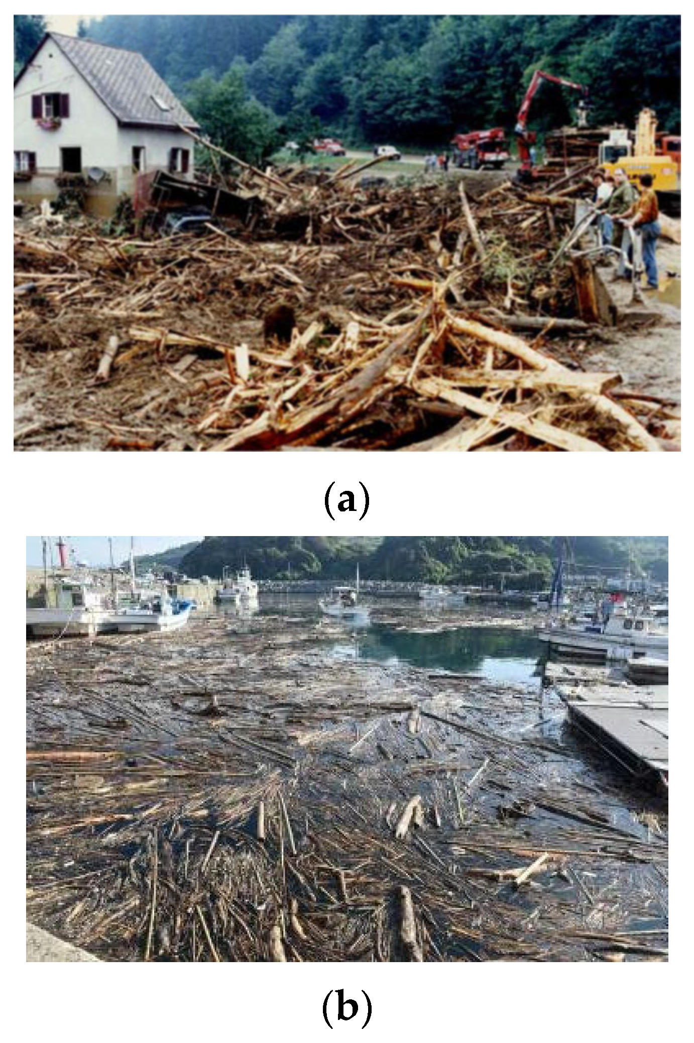
In recent years, extensive forest deforestation has been caused by woody debris outflows (Figure 1a) following landslides triggered by global warming-related heavy rain events [1,2]. Approximately 75% of Japan’s land area is mountainous, most of which is covered by forests; thus, there are concerns regarding the occurrence and hazards of large amounts of woody debris produced through landslides and bank collapses [3], particularly along mountain streams and around reservoirs [4,5]. Past disasters have revealed that woody debris and sediment blockages can damage bridges and culverts, leading to significant outflow and/or flooding upstream of the blockage [6,7,8,9]. Woody debris flows also tend to create problems in coastal areas (Figure 1b). However, previous studies mainly examined woody debris damage at individual sites, and comprehensive studies of woody debris flows in entire basins are lacking.
Check dams that trap both sediment and wood were initially designed as vertical, inclined buttresses or grids [10,11]. However, impermeable sabo dams are not equipped to capture woody debris [12]. Improvements to permeable sabo dams [13], which have a high woody debris capture capacity, are currently underway; these sometimes include the addition of steel fittings in Japan [14].
In July 2017, a heavy rain disaster occurred in northern Kyushu, Japan. Impermeable sabo dams in some basins were unable to fully capture the resulting woody debris, which flowed downstream, causing extensive damage to houses and bridges [15]. However, concrete construction methods are inappropriate in this region; therefore, it is necessary to propose alternative countermeasures that complement the characteristics of the basin.
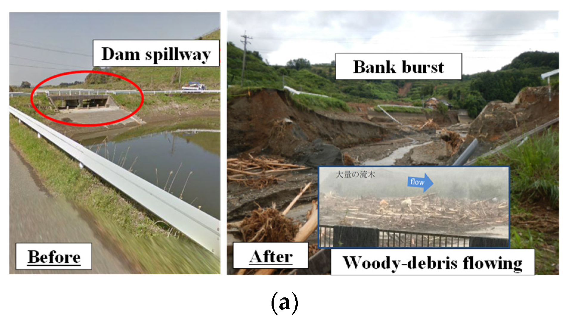
During the disaster, large amounts of woody debris were not captured by impermeable sabo dams, and flowed into downstream agricultural ponds (Figure 2a). The pond embankments eroded and overflowed, ultimately collapsing due to spillway blockage, which inhibited proper drainage. These collapses led to significant damage downstream [8,9]. By contrast, the impermeable Sugawa sabo dam I (Figure 2b) exhibited robust woody debris capture [16]. Thus, the woody debris capture capacity of impermeable sabo dams requires further study. In response to this 2017 heavy rain disaster, emergency countermeasures were proposed, including mountain streams and downstream areas in the basin [17]. However, the mechanism underlying the extensive woody debris damage that occurred during this event remains to be clarified.
To date, woody debris countermeasures for mountain streams, bridges, and downstream river areas have been established on an individual basis (e.g., stakes to prevent bridge blockages; Figure 3). Proposed countermeasures have included woody debris capture by pile dikes at curves in the river [18,19]. We previously described the highly developed woody debris capture function [20,21] of impermeable sabo dams, which exploits the rotational motion of wood to trap woody debris in flooded areas, as well as the installation of stakes to prevent bridge blockages [22]; the effectiveness of these methods has been experimentally demonstrated. We have also investigated woody debris capture by concrete slit dams [23]. Notably, if a woody-debris capture pile is installed in the river channel, both woody-debris and everyday garbage blockage may become problems [24].
In this study, we examined the mechanism of woody debris outflow during the 2017 northern Kyushu heavy rain disaster. Based on our findings, we propose countermeasures that consider the woody debris runoff characteristics. Then, we discuss the design and effectiveness of woody debris countermeasures for entire watersheds in the unique topography of Japan, as well as the effectiveness of these measures.
2. Woody Debris Runoff Characteristics and Damage Risk
When planning woody debris countermeasures, both the debris and runoff characteristics must be considered. Therefore, we analyzed a woody debris flow that occurred in the Yahagi Dam reservoir, using previous detailed survey results [25]. The amount of woody debris for each inflowing tree species was divided by the location-specific forest composition ratio of the basin forest to obtain a dimensionless parameter. The woody debris runoff rate (Ri_out) for each tree species at Yahagi Dam (Figure 4) was calculated as follows:
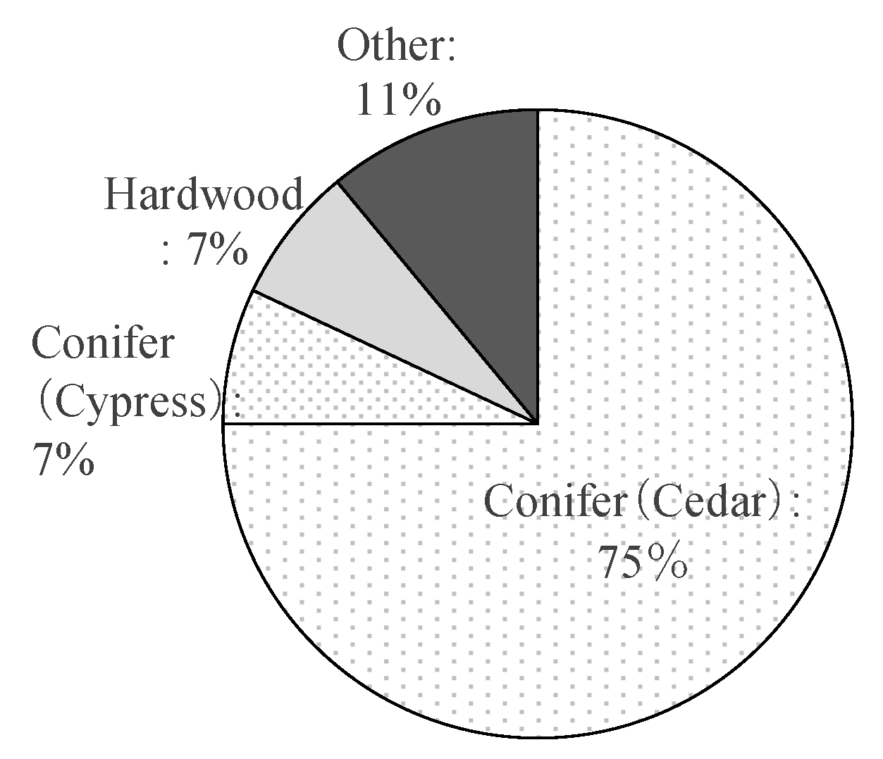
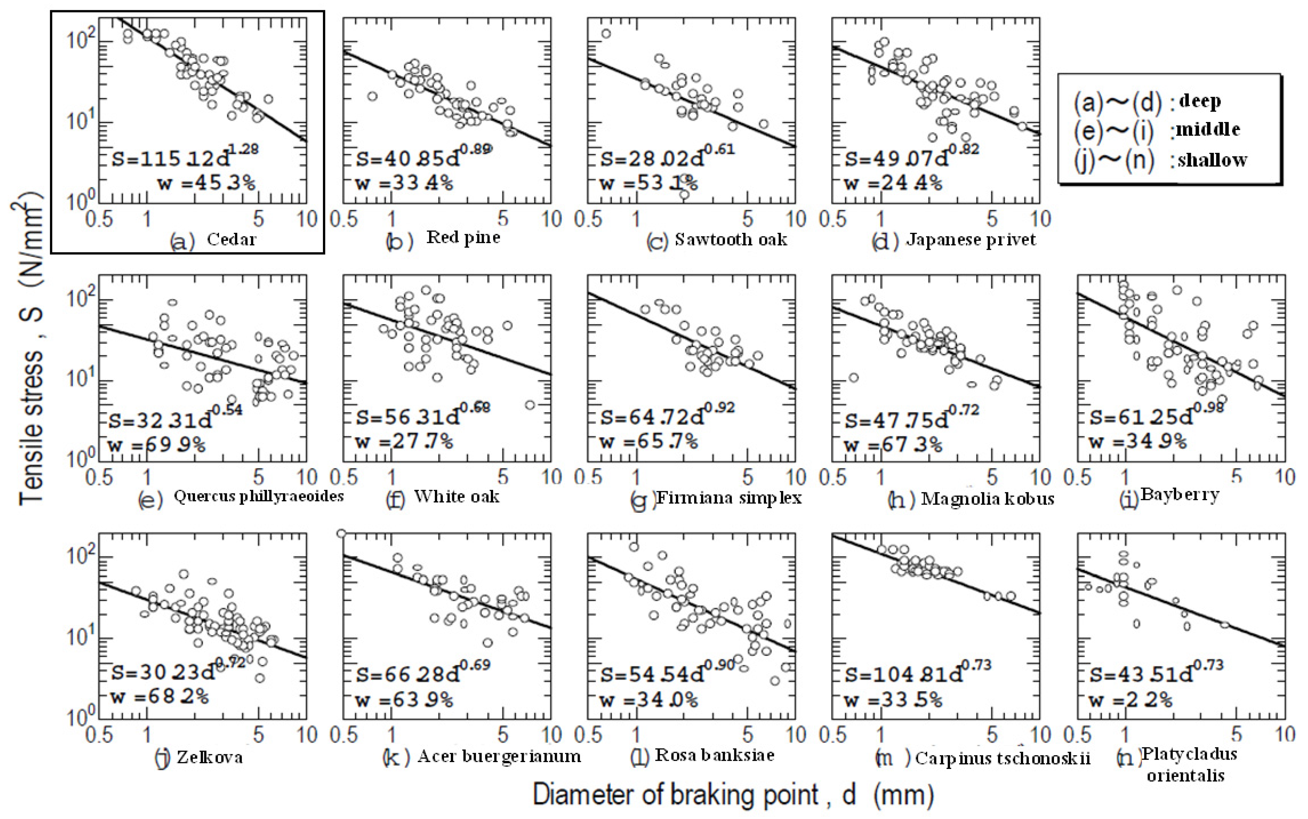
where ni_c is the number of wood pieces of each tree species that flowed into the reservoir and Ai_e is the forest composition ratio (i.e., tree species area ratio in the basin). Japanese cedar had a significantly higher outflow rate than all other tree species (Figure 4), which may be attributed to differences in bond strength among the roots of individual tree species, as well as ground environment characteristics such as slope stability. Figure 5 shows the root tensile strengths [26] of various tree species with respect to tree diameter, which is an indicator of the relationship between the root bond strength and the woody debris runoff rate of each tree species; these relationships did not explain the high proportion of Japanese cedar in woody debris runoff. Cedar has high water requirements [27,28] and is often reforested on slopes and along valleys due to its high water content. Thus, it may be that differences in woody debris runoff rates are strongly influenced by the relationship between soil water content on slopes where cedars grow and the probability of landslide occurrence [29].
Ri_out = ni_c/Ai_e
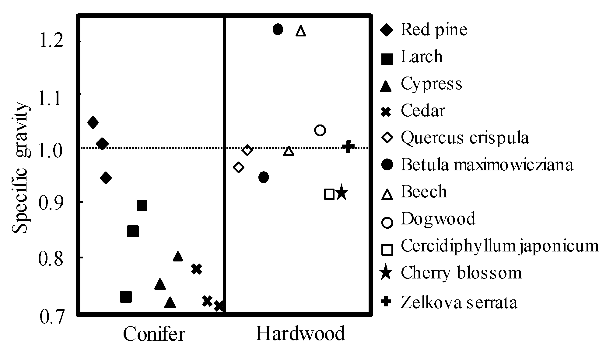
Figure 6 shows specific gravity values for living trees of various species [30]; compared with hardwoods, conifers have lower specific gravity. In particular, cedar and cypress species tend to have significantly lower specific gravity, ranging from 0.7 to 0.8. Generally, during flood conditions, the specific gravity of running water increases according to its sediment concentration. Therefore, downstream damage may be caused by long-distance transport of woody debris in relation to increased buoyancy. Thus, cedar, which grows on slopes with a high risk of landslide related to high soil water and low specific gravity, may represent a higher proportion of downstream woody debris than other tree species.
To date, most previous studies have investigated the risk of individual woody debris disasters. Previous woody debris outflows affecting houses, infrastructure, flooded upper channels, and reservoirs and coastal ports in various parts of river basins in Japan are presented in Table 1.
3. Woody Debris Runoff Characteristics
To understand the runoff characteristics and capture functions of sabo dams, we will discuss the results with respect to the Northern Kyushu heavy rain disaster, in which a large amount of woody debris caused heavy damage (Figure 2a,b).
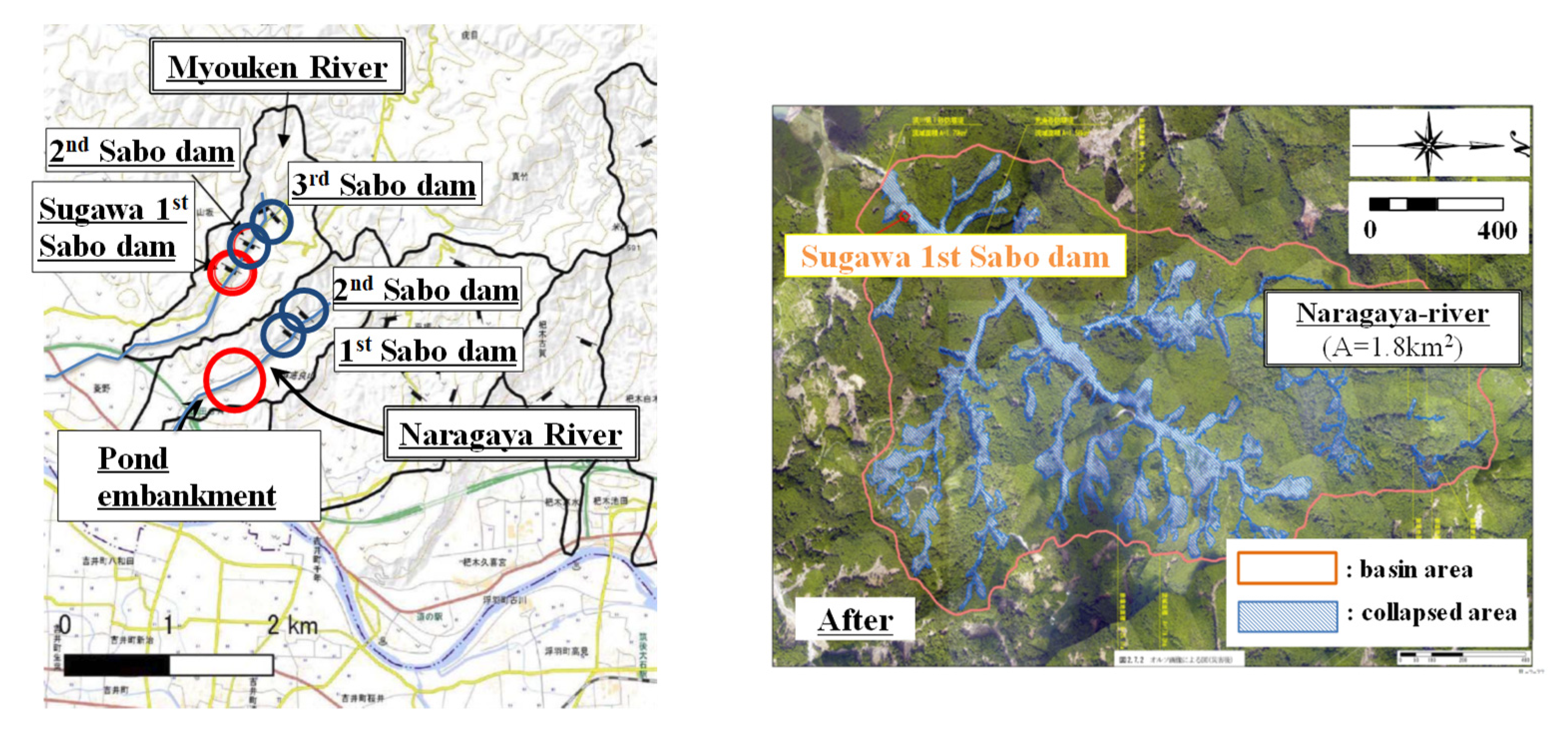
We examined woody debris damage in the Myoken River basin (Figure 7), where woody debris was captured by the impermeable sabo dam shown in Figure 2b. We also examined damage that occurred in the Naragaya River basin, where large amounts of woody debris escaped an impermeable sabo dam and flowed into a downstream agricultural pond (Figure 2a), leading to considerable damage.
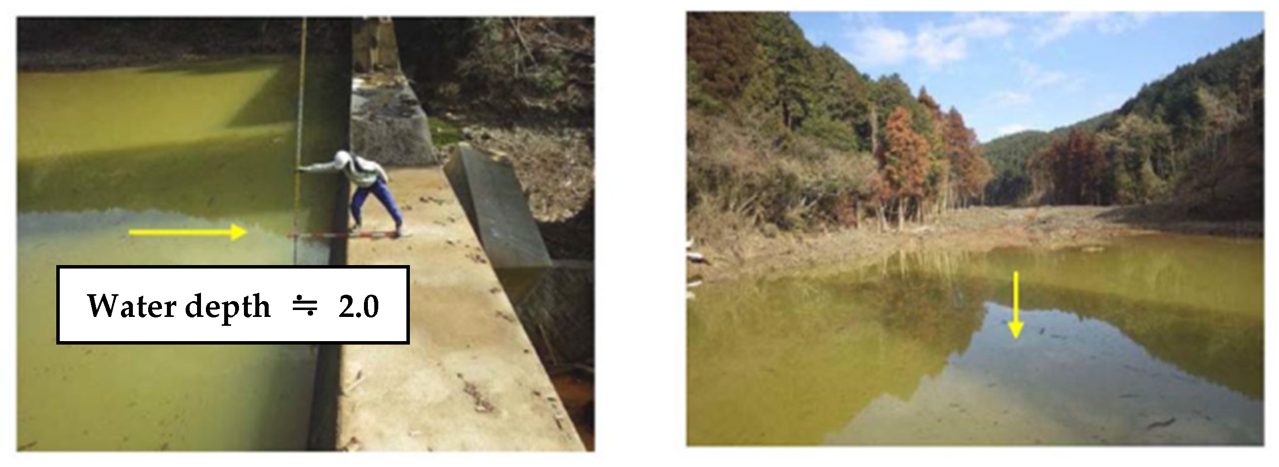
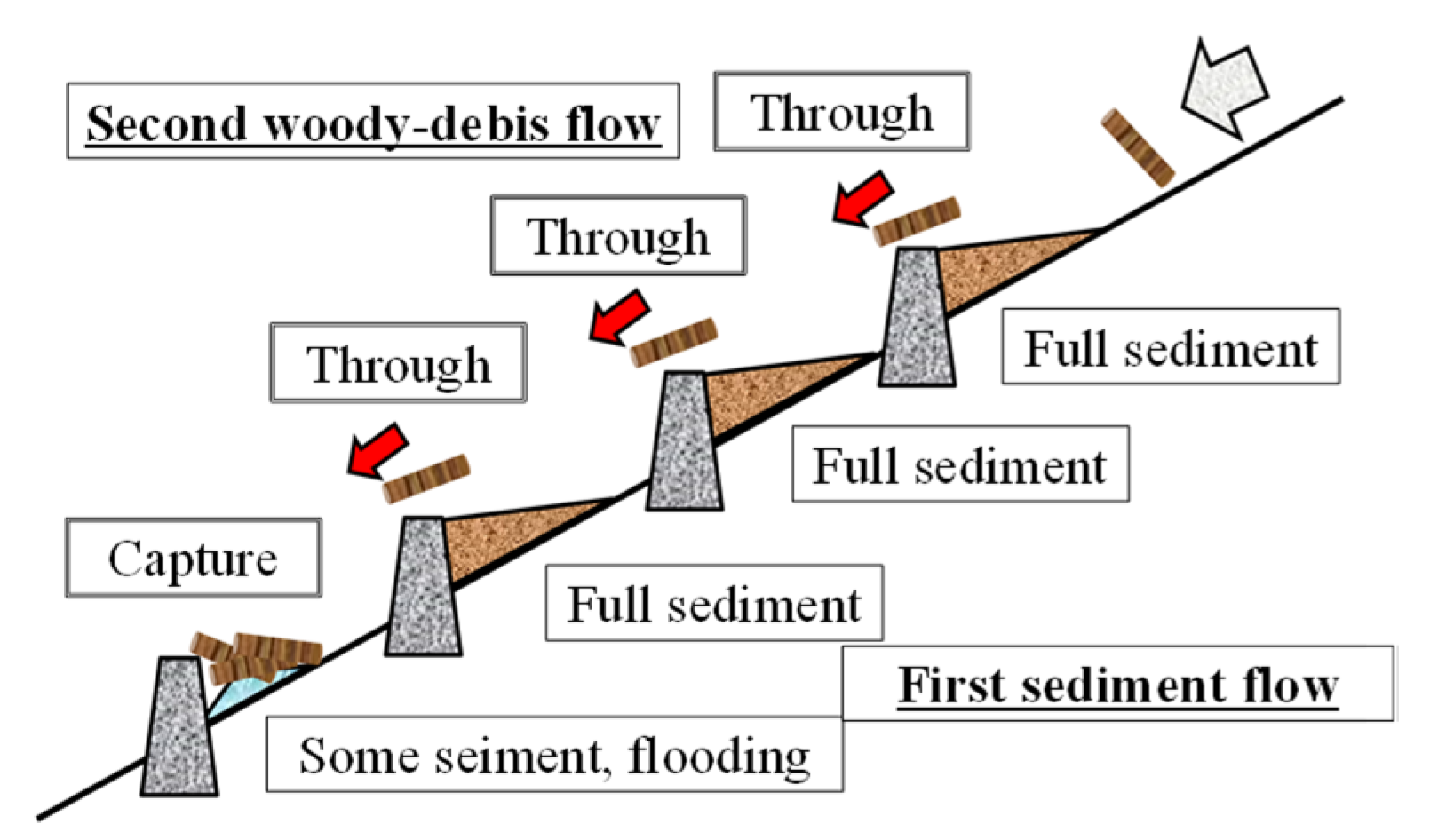
Table 2 shows the outline of the target sabo dam in the Myoken and Naragaya River basins. Sabo dams other than Sugawa sabo dam I (Figure 2b), which exhibited robust capture capacity, were less sandy before the disaster. This finding suggests that the difference in sedimentation conditions at the impermeable sabo dam before woody debris outflow did not significantly affect the capture function. By contrast, after the sabo dam disaster, all dams except Sugawa sabo dam I, trapped only sand as sediment. As shown in Figure 8, the bottom surface of the captured woody debris shown in Figure 2b was flooded to a water depth of approximately 2 m, even after the disaster, and delta sedimentation was confirmed [40]. As shown in Table 2, these findings indicate that sufficient sediment did not reach Sugawa sabo dam I, which was the furthest downstream, where woody debris was strongly captured during the disaster. This sediment flow pattern presumably occurred because large amounts of sediment were captured by multiple impermeable sabo dams upstream; moreover, the riverbed slope at Sugawa sabo dam I was loose.
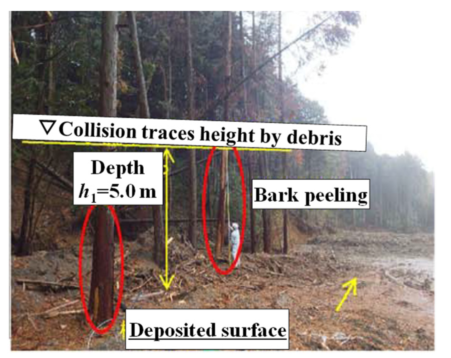
Figure 9 shows the woody debris flow and collision damage at a height of approximately 2–5 m above the deposited riverbed height after the disaster. We presume that the woody debris passed along the upper layers of the deposited sediment flow.
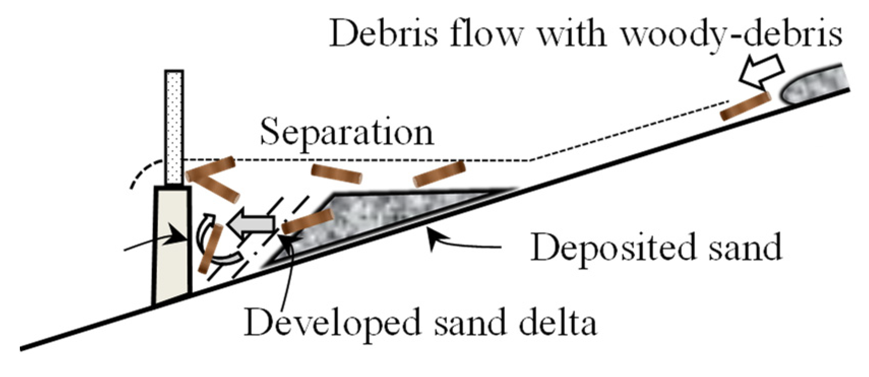
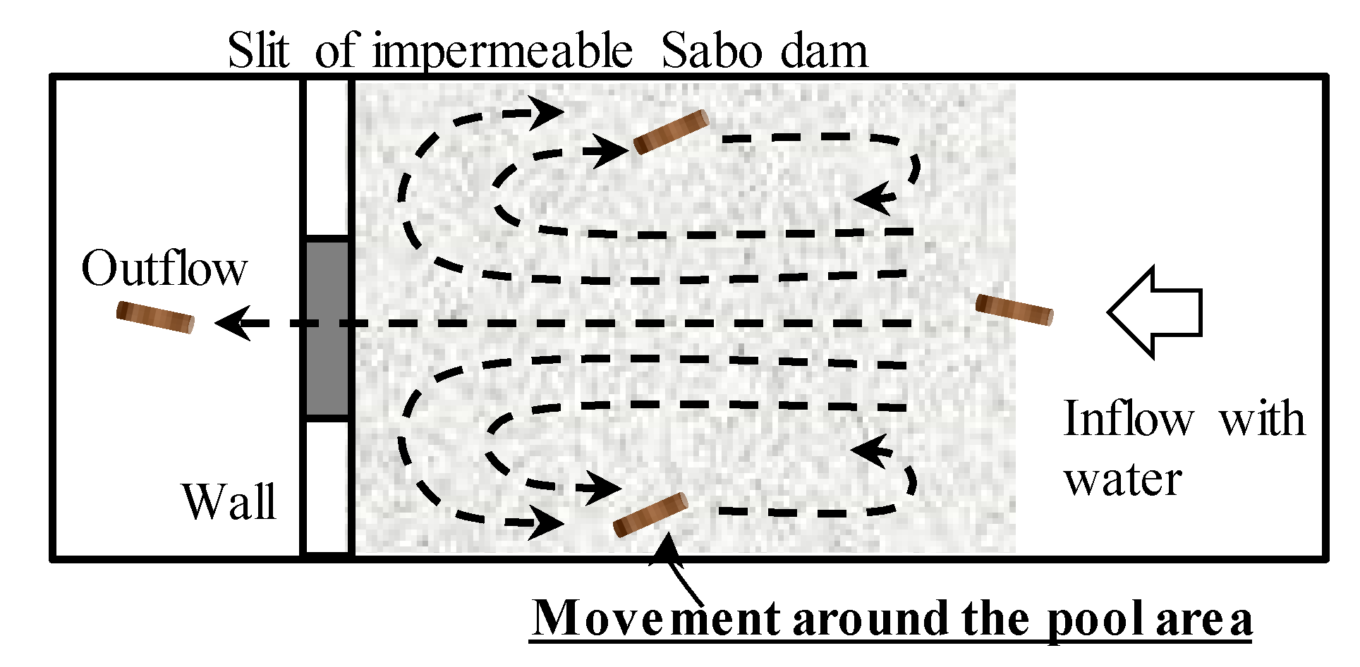
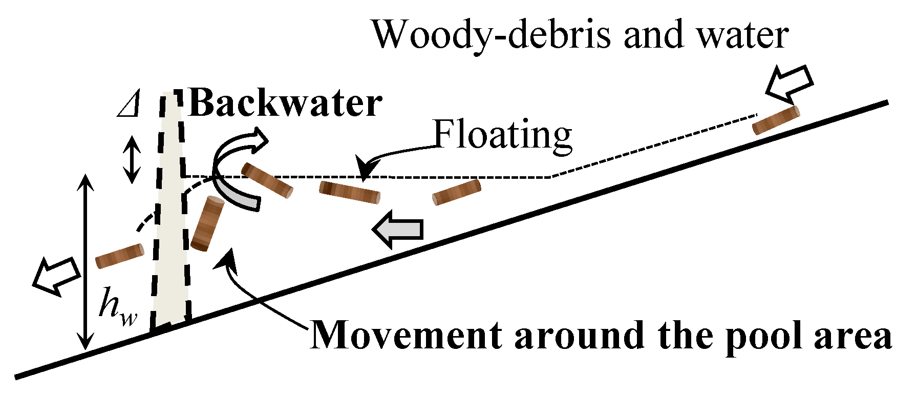
A previous study reported that an impermeable dam flooded without sand had an altered flow plane, which induced swirls on the water surface [3]. Thus, woody debris rotates during transport. Figure 10 shows a mechanism by which woody debris is finally captured in a flooded area. Figure 11 shows a cross-sectional view of sediment deposition and woody debris behavior in the vertical direction in the flood area of an impermeable sabo dam [20]. The separation of sediment and woody debris flowing from upstream begins in the flood area; sediment is deposited through delta sedimentation [40]. The separated woody debris floats and rotates due to vertical secondary flow caused by the dam, allowing the wood to be captured [21]. Thus, the woody debris capture function of Sugawa sabo dam I was affected by flood backwater immediately upstream. However, flooding may also have occurred at impermeable sabo dams further upstream, which contained less sand before the disaster (Table 2). Woody debris was not captured in the sedimentation parts of any sabo dams other than Sugawa sabo dam I (Table 2); therefore, further research is necessary.
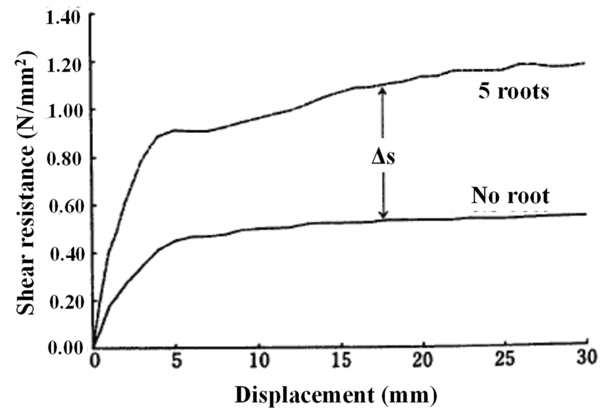
Soil generally moves together during a slope landslide, usually carrying trees along with it [41]. This phenomenon is at least partly caused by soil shear resistance, which is affected by the presence and density of tree roots [42,43]. Figure 12 shows differences in shear resistance in soil with and without tree roots.
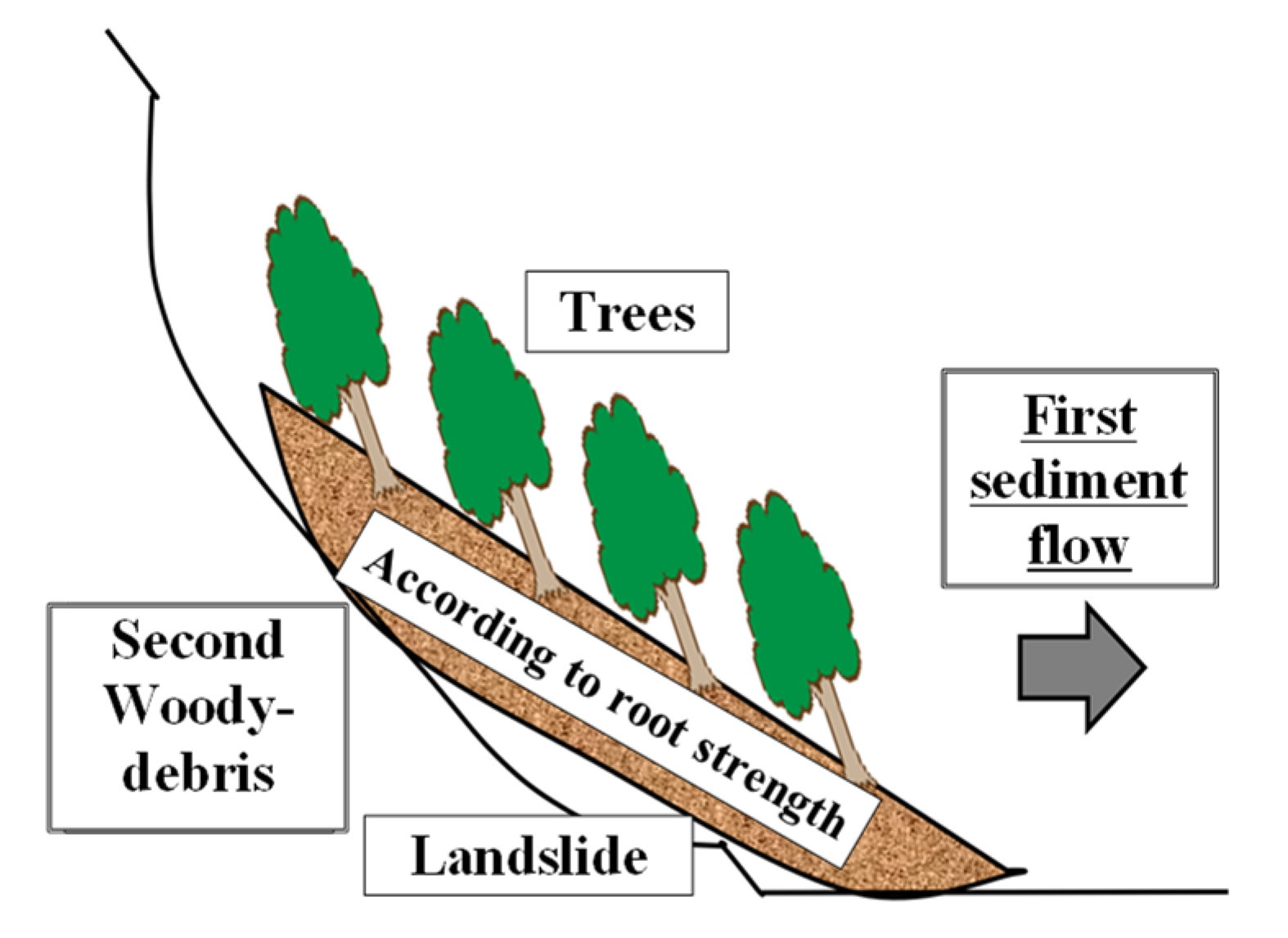
Slope failure is the main cause of woody debris flow during a landslide. The slope collapses to a depth of approximately ≥2 m, initiating flow. As shown in Figure 13, the slope soil appears to slide downward without separation [41] because of the shear resistance of tree roots. Singularized woody debris outflows occur after sediment outflow due to erosion and soil separation from roots with subsequent water flow. Therefore, the impermeable sabo dam was already full of sand before the woody debris flowed downstream (Figure 14). Subsequently, the woody debris flowed over the upper part of the impermeable sabo dam, which had become filled with sand (Figure 9). These are some of the factors that influence woody debris capture at sabo dams. There has been limited discussion regarding the woody debris generation mechanism or deposition changes over time, for example, [15].
4. Effective Woody Debris Countermeasures throughout the Watershed
Woody debris has low specific gravity (Figure 6), and therefore floats downstream relatively easily (Table 1). To promote the formulation of effective countermeasures against woody debris damage [18] throughout entire basins (i.e., from mountain streams to downstream estuaries), we briefly review the design and structure of selected countermeasures implemented to date. Then, we describe technical findings of our previous research that could improve the functionality of these countermeasures (e.g., stakes to prevent bridge blockages; Figure 3).
4.1. Main Woody Debris Countermeasures and Technical Notes for Various Basin Area Divisions
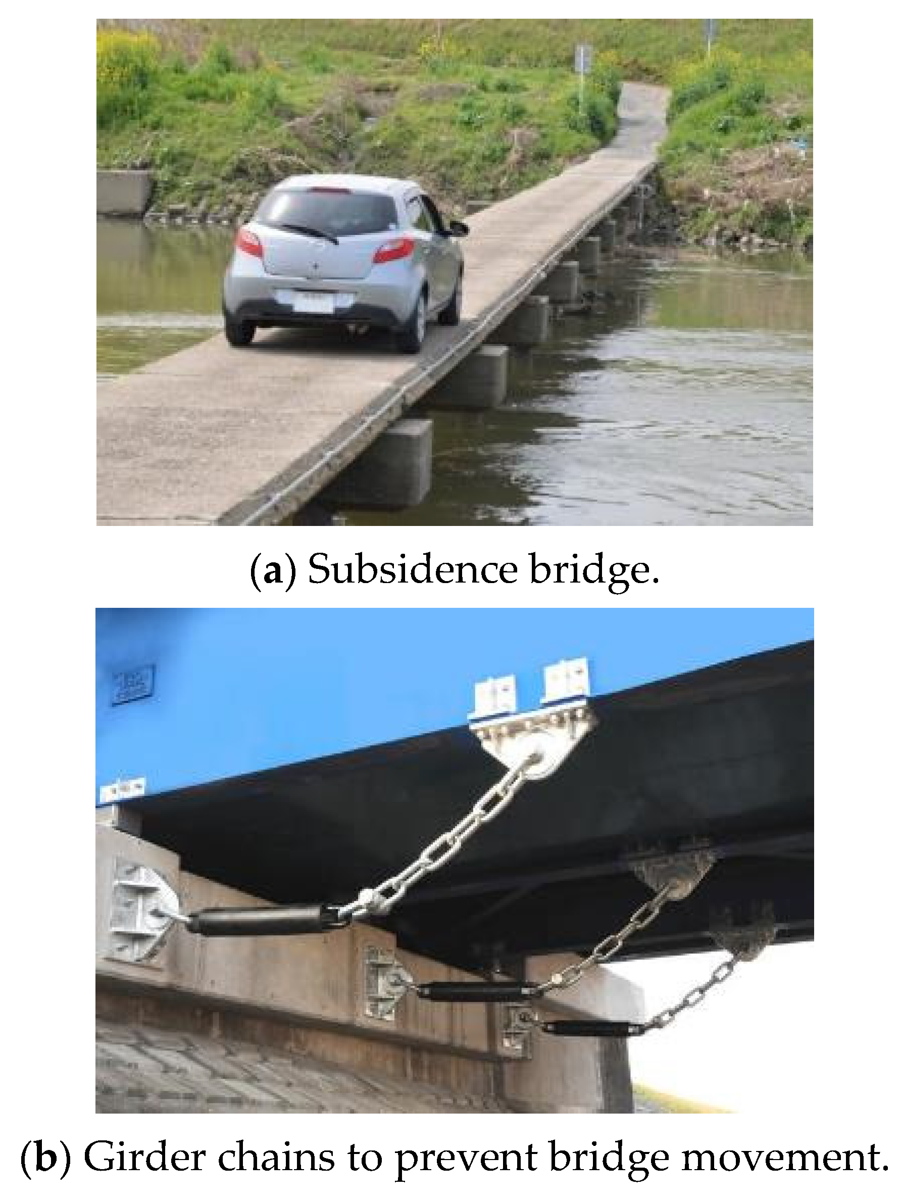
Table 3 shows the main countermeasures implemented in Japan for reducing woody debris damage for different basin elements, including rivers on slopes, sabo dams, and bridges, as well as the maintenance requirements and risks associated with these measures. Notably, mountain channels with several sloping reaches, as well as tributaries, require multiple countermeasure installations such as sabo dams because woody debris runoff can lead to further accumulation and blockage downstream. Regular maintenance such as the removal of sediment and woody debris is a key feature of blockage removal countermeasures. Submersible bridges (e.g., the Shimanto River Itto-tawara Bridge; Figure 15a) have been implemented in several regions; these bridges include floor slabs without balustrades. Additionally, bridge collapse prevention devices (Figure 15b) such as girder chains are important in regions where rivers are blocked by woody debris [33].
4.2. Woody Debris Capture Mechanism of Conventional Stakes for Bridge Blockage Prevention
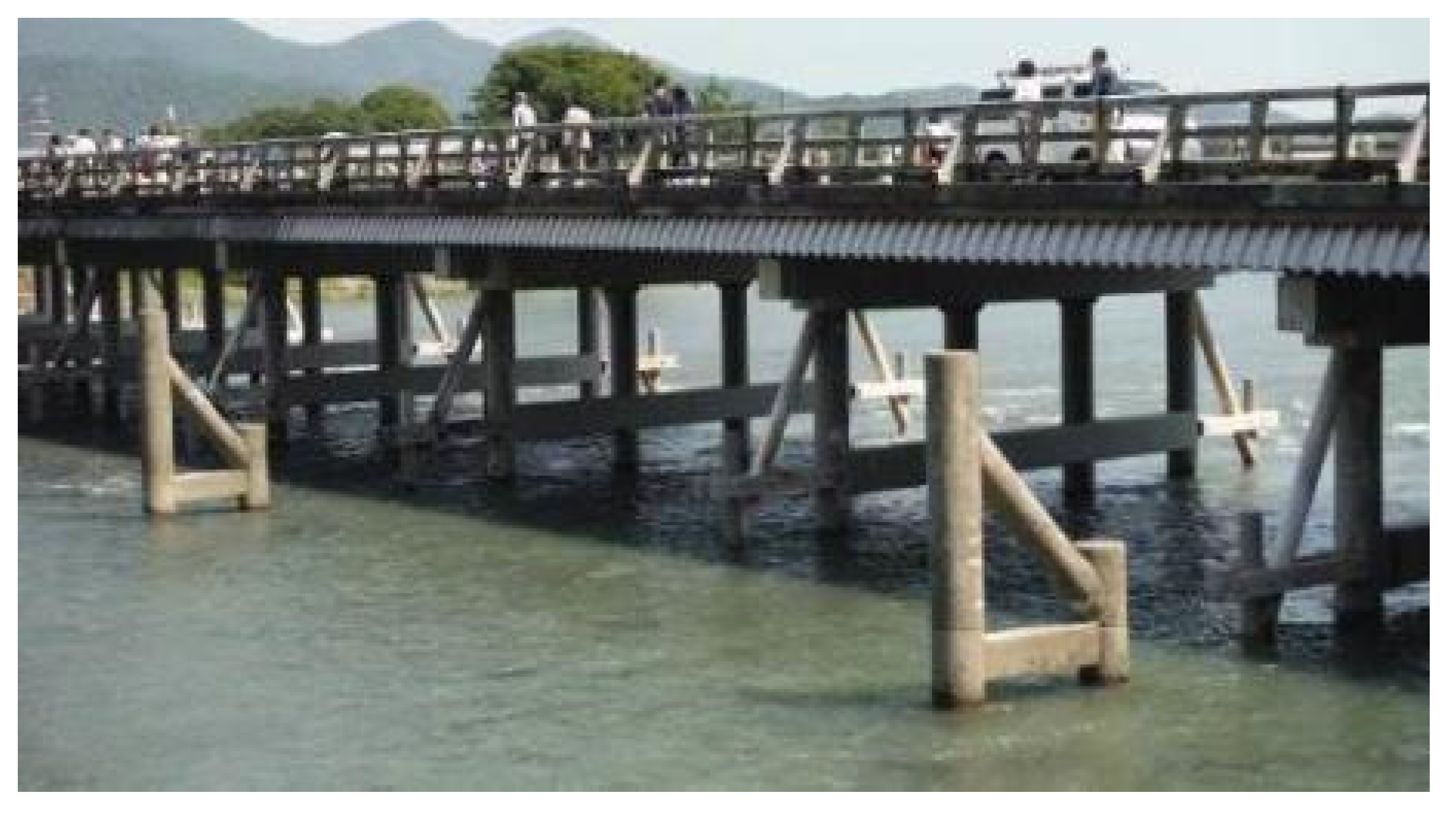
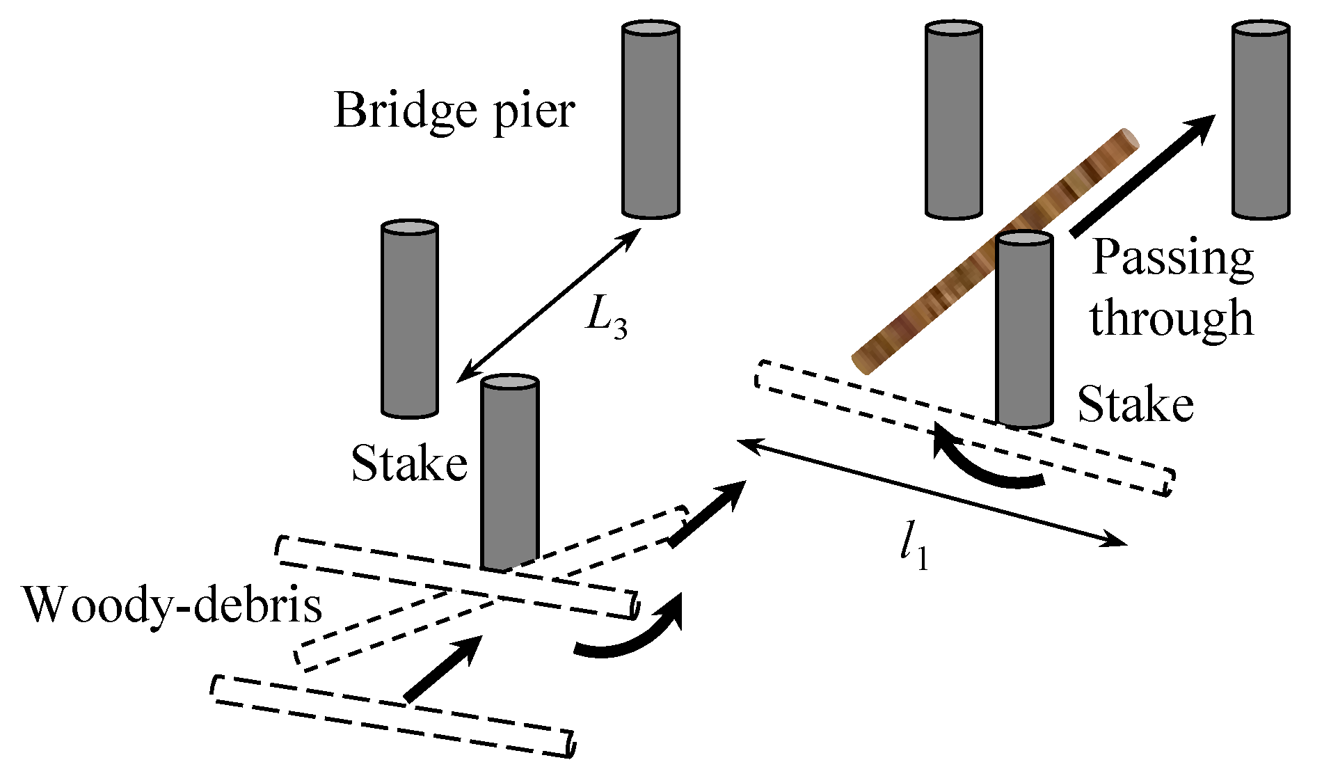
Stakes have been installed to prevent bridge blockages by woody debris in Japan since ancient times [22]. This conventional measure exploits the tendency of floating woody debris to rotate around an obstacle, slowing the debris flow upstream of the bridge and allowing the debris to re-orient to pass between its piers, providing some degree of control over the debris flow direction (Figure 3 and Figure 16).
However, because there are no cases where existing stakes (such as the Uji Bridge inside the Ise Grand Shrine) are continuous upstream and downstream, additional experiments are needed regarding the effectiveness of this installation arrangement.
4.3. Woody Debris Capture Mechanism of the Flooding Areas of Concrete Slit Sabo Dams and Agricultural Ponds in Downstream Rivers
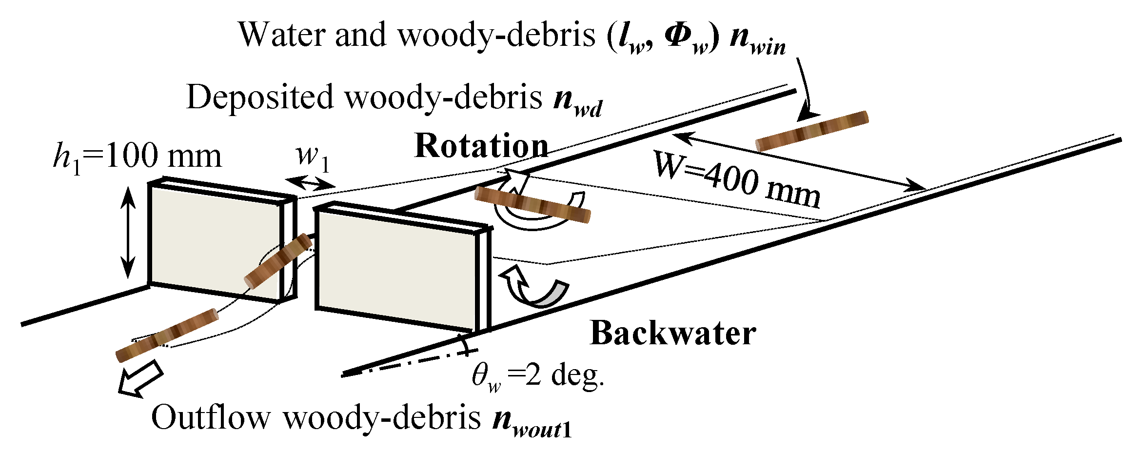
Figure 17 shows an outline of our experiment designed to explore the woody debris capture function of the flooding sections of a concrete slit sabo dam, reservoir dam, and agricultural pond in downstream river sections [23]. Water was injected upstream with woody debris models in a straight waterway to observe the capture of woody debris in the flooding area, as shown for the concrete slit sabo dam in Figure 18.
Additionally, woody debris was transported outside of the flooding surface under the influence of three-dimensional water level distribution (backwater effect caused by dam up; Figure 19) in the flood area upstream of the slit wall. These observations revealed the effect of temporary woody debris capture in the flooding area (Figure 18). However, after the upstream water supply was stopped, this backwater effect also stopped, allowing woody debris captured in the flooding area to flow downstream through the slit. As an additional outflow countermeasure for this woody debris capture mechanism, we have proposed an effective outflow prevention method in the slit area.
4.4. Considerations for the Construction of a Partially Transparent Sabo Dam
A steel woody debris countermeasure structure has been proposed to enhance the capture function of impermeable concrete sabo dams; its effects have been investigated experimentally [20,21]. For example, the capture structure of the apron in the sub-dam portion of a permeable Sabo dam and its downstream effects are shown in Figure 20 [20]. The impermeable concrete structure in the vertical lower part and the steel pile structure in the upper part are effective for woody debris capture, as indicated for the partially permeable sabo dam shown in Figure 21. Because sediment and woody debris are separated in flooded areas, woody debris and running water transported downstream are rotated vertically upward by the dam structure in a backwater effect, and are then captured by the upper pile [20]. These observations indicate that stone removal from the upper part of the dam should be performed as regular maintenance to ensure proper capture function of the sabo dam.
5. Proposal of a New Woody Debris Countermeasure Considering Terrain Characteristics
The countermeasure described above does not consider terrain characteristics at the location of the facility installation. To effectively manage woody debris capture and removal, we propose a new containment structure.
5.1. Proposal of a Woody Debris Countermeasure Considering Outflow and Debris Rotation
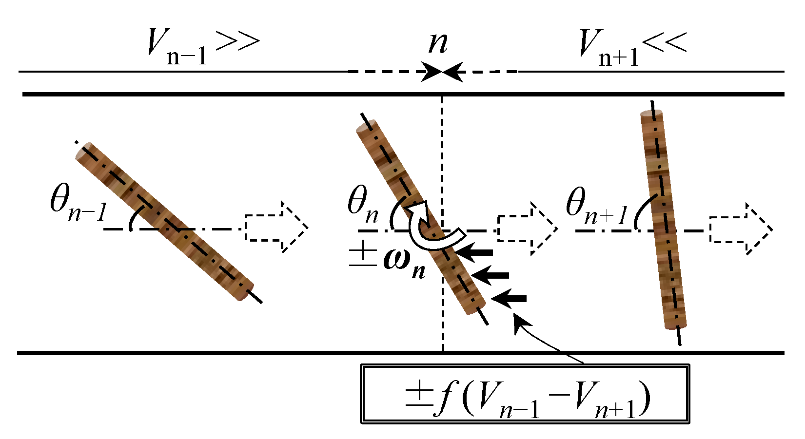
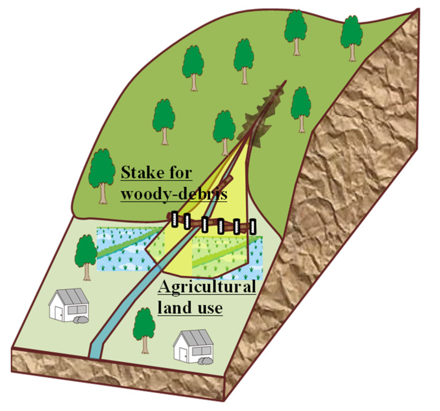
We propose a new woody debris countermeasure designed based on previous disaster cases [15]. If sediment is produced and outflows before the woody debris outflow (Figure 14), there is a risk that the area upstream of the sabo dam will be filled with sand and other sediments, hindering woody debris containment. Thus, woody debris capture (distinct from sediment capture) is even more important in the downstream area. However, when there are houses downstream of the nearest valley exit, reliable countermeasures are needed on the upstream side of their conservation targets. Furthermore, woody debris rotates in the flow direction because of the sudden change in flow from a gentle slope to a steep slope immediately upstream of the woody debris capture structure. For example, the difference in velocity Vn ± 1 shown in Figure 22 is due to rotation caused by the woody debris rotating force ωn. Additionally, the pile interval of woody debris capture structures used throughout Japan is approximately half of the typical maximum debris wood length [13]; if this interval is excessively wide, then the woody debris passes between the piles without interference. Conversely, if the pile interval is excessively narrow, then daily maintenance is required to prevent blockage by garbage.
Therefore, to capture woody debris even for widely spaced pile countermeasures, a flow-perpendicular method must be implemented [23]. As shown in Figure 23, rapid flow can be slowed by the installation of a woody debris pile countermeasure at the nearest valley exit upstream of the flood zone. Daily running water is drained by channel construction. In this scenario, large amounts of sediment and woody debris (100-year exceedance probability scale) overflow channels that have insufficient flow capacity, allowing the sediment and woody debris to be captured by the surrounding flat land. For example, the placement of woody debris capture piles on ridges and the use of other flat lands as fields during non-flood periods is an effective use of the land. Here, we confirm the rotation of woody debris that can be expected when flowing down a precipitous channel to a flat area with a gentle slope.
5.2. Experimental Method
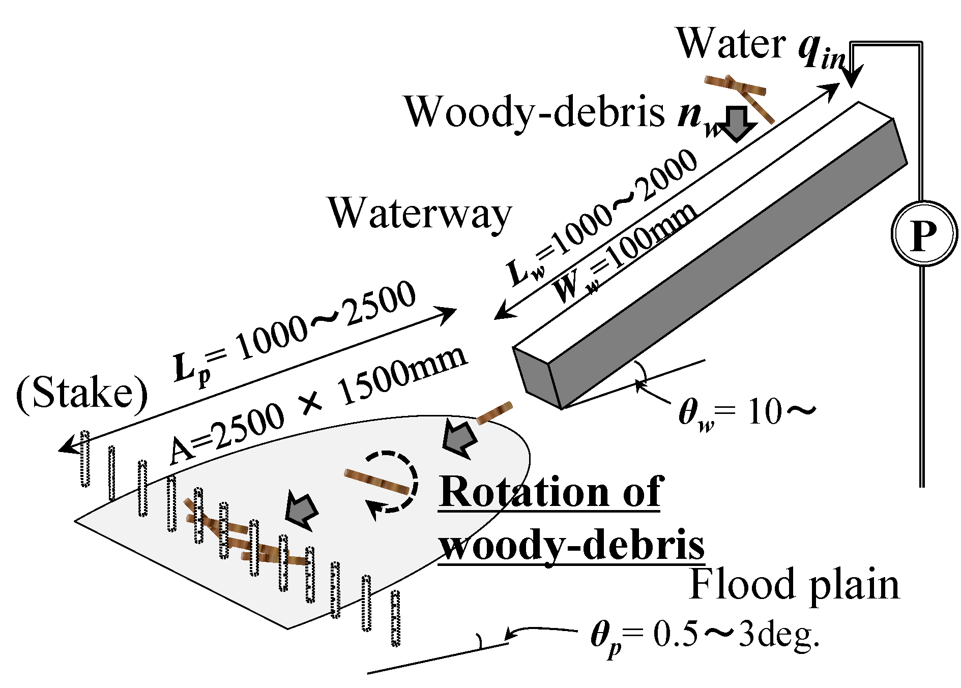
Figure 24 shows the rapidly expanding straight and plane flood waterways used in this experiment. Using scale models (~1/100), we supplied water (qin) and woody debris from upstream of an inclined straight waterway (width, 10 cm). The water supply was kept constant until debris outflow was completed. The axial direction θn of the woody debris (Figure 25) was measured immediately before debris capture on the flood waterway. In a preliminary experiment, the bottom roughness of the channel had a significant effect on driftwood rotation; therefore, we used a smooth surface. The cylindrical model wood pieces were 8 cm in length, with a specific gravity of approximately 0.75 when dry. The wood pieces were introduced at a rate of approximately one piece every 0.5 s. To prevent the initial woody debris direction from affecting the rotation control effect, the debris was injected at a nearly identical rate in all directions (Figure 25).
The inclination angle of the straight waterway was based on the debris flow area (>10° [13]). As shown in Figure 24, the woody debris injection position L and the evaluation (capture structure) position Lp in the final woody debris direction (Figure 25) on the plane flood waterway varied. To understand the effects of these experimental conditions on woody debris rotation, we varied the water discharge (qin), waterway gradient (straight waterway, θw; plane flood waterway, θp), and woody debris diameter (φ1). To reduce the influence of manual woody debris input, the experiment was performed three times under the same conditions (Table 4) and the results were averaged.
5.3. Results and Discussion
In our experimental analysis, the woody debris rotation rate fc associated with changes in flow was calculated as follows:
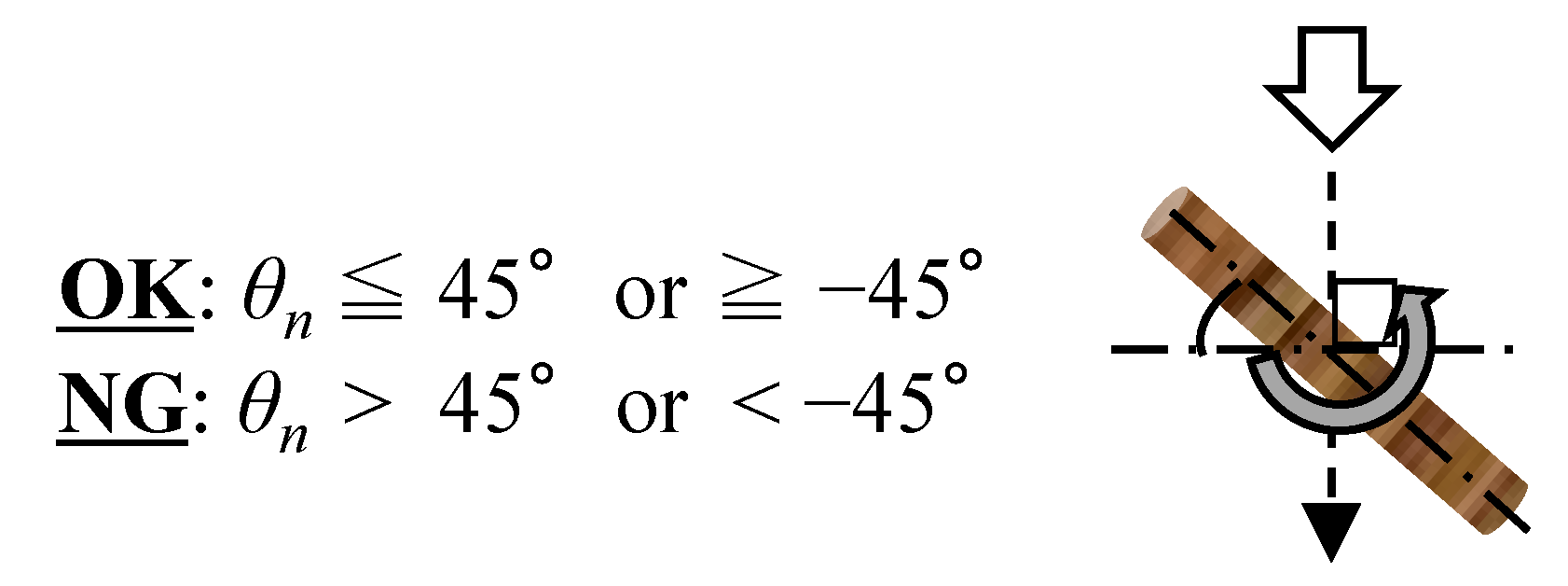
where n0 is the number of debris pieces at θn ≤ 45° (Figure 25) at measurement position Lp on the plane flood waterway, and nw is the number of debris pieces supplied (=30). In Japan, the interval between woody debris trapping piles is half the length of the woody debris; driftwood is expected to pass through the countermeasure structure when θn > 45° [13].
fc = n0/nw
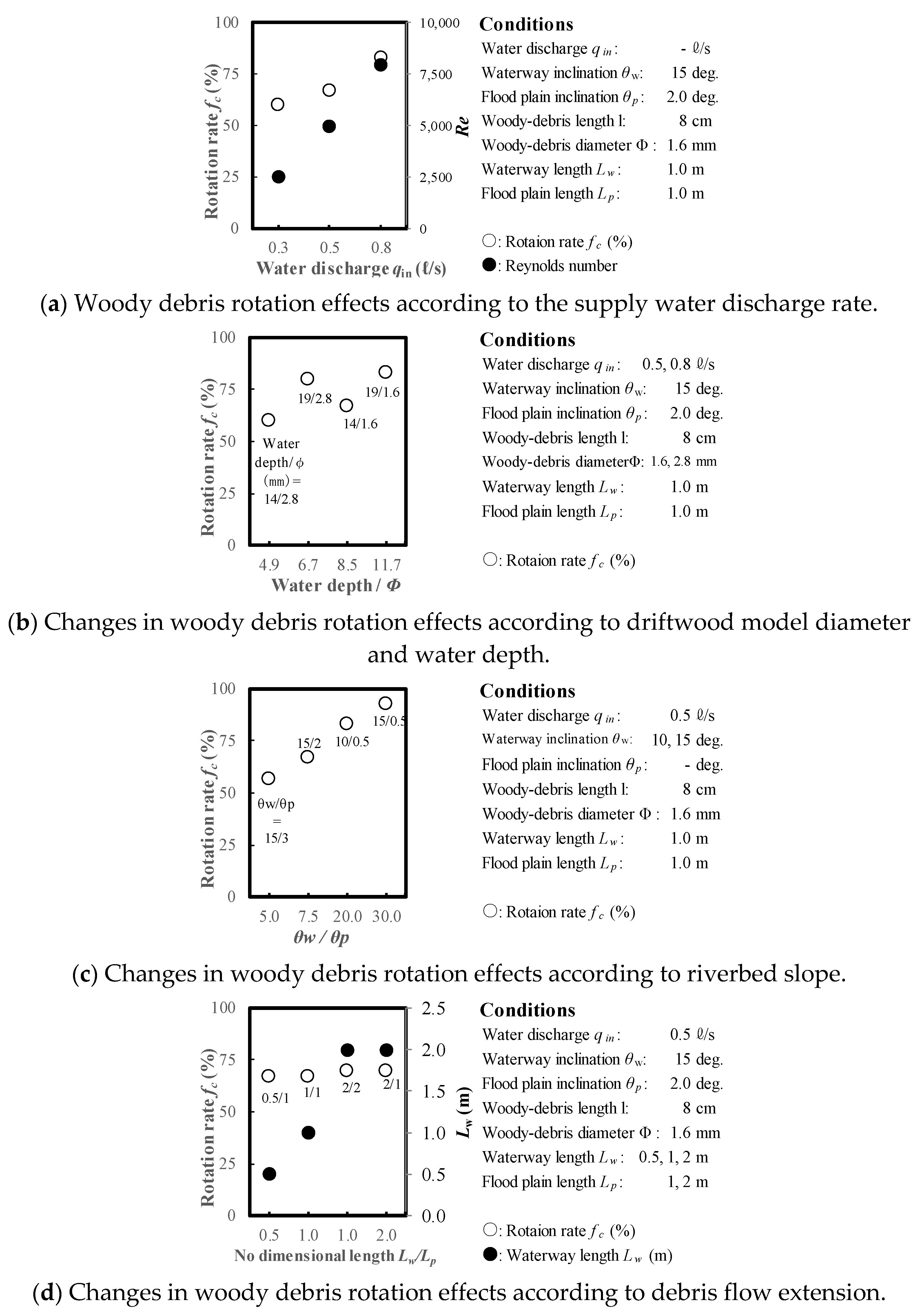
Figure 26a shows changes in the woody debris rotation rate fc according to supply water discharge. On the plane flood waterway, the woody debris rotated (Figure 22) due to the difference in velocity. This rotation was presumably caused by the increasing velocity difference between upstream and downstream areas with enhanced water discharge.
Figure 26b shows changes in the woody debris rotation rate fc according to driftwood diameter and water depth. When the driftwood diameter was small and the water was deep, the woody debris rotation effect increased. The upstream and downstream velocity difference increased with increasing water depth (i.e., water discharge). These results can be explained by the lower weight of the woody debris, which allowed it changes rotate more easily in response to changes in flow.
Figure 26c shows changes in the woody debris rotation rate fc according to riverbed slope (i.e., the slope ratio of the straight waterway to the plane flood waterway). A change in velocity associated with the change in riverbed slope affected driftwood rotation. Most of the woody debris was caught at slope ratios ≥ 30.
Figure 26d shows changes in the woody debris rotation rate fc according to woody debris flow extension (i.e., woody debris injection position Lw and evaluation position Lp in the woody debris direction on the plane flood waterway). Flow extension had little effect on driftwood rotation. Notably, woody debris rotation effects also occurred at locations where the flow velocity changed.
These results indicate that piles can be arranged at wide intervals to create an effective woody debris capture structure that takes advantage of the change in terrain at the nearest valley exit, while minimizing maintenance efforts. However, further experiments are required to study its effectiveness under various topographical and water flow conditions prior to field application.
6. Proposed Woody Debris Countermeasure Based on Basin and Woody Debris Flow Characteristics
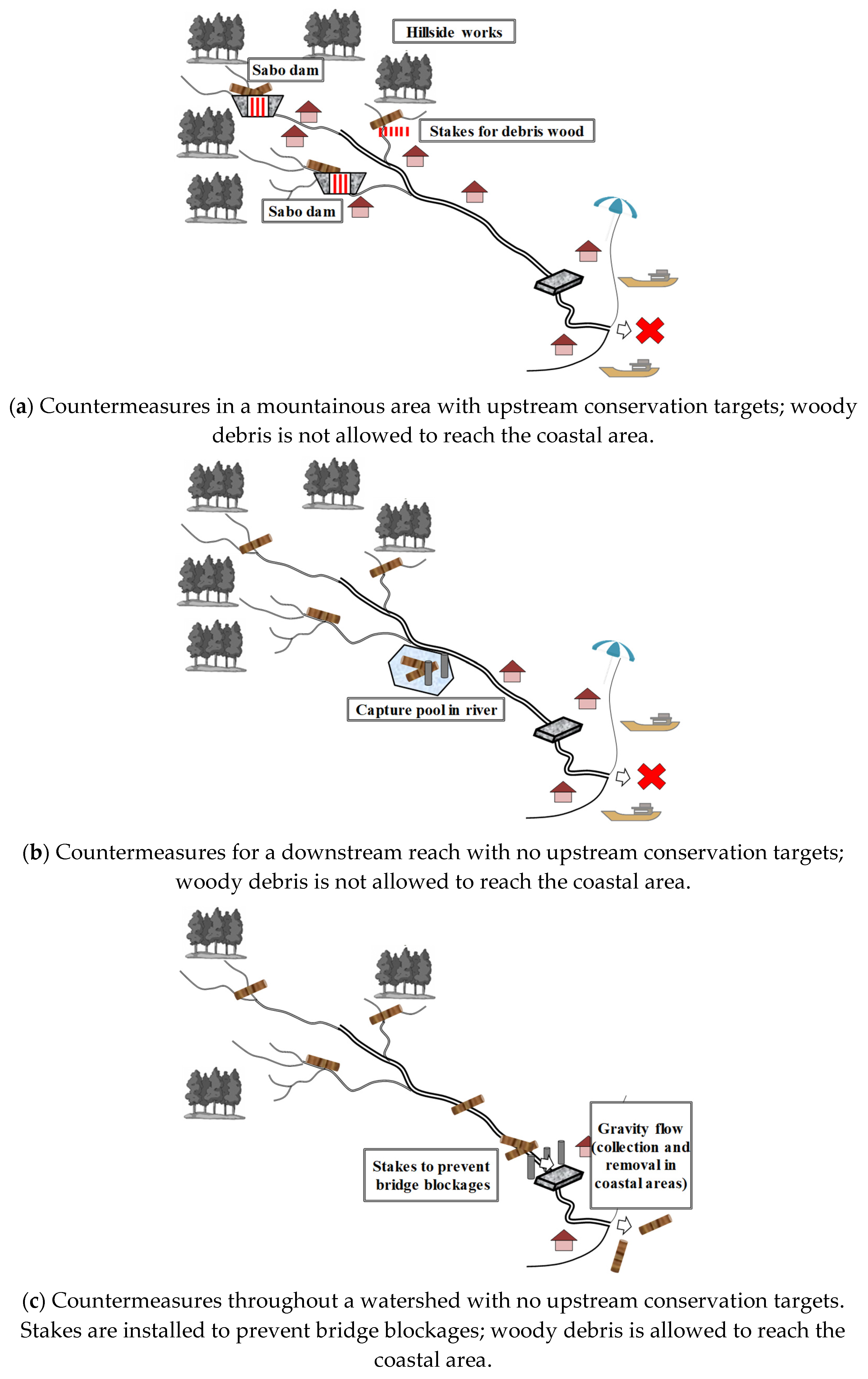
Table 1 lists previous debris flow damage associated with various basin and runoff characteristics, and Table 3 describes proposed countermeasures that consider topography, conservation targets, and basin characteristics. Conservation targets in upstream areas of mountain streams require countermeasures to prevent woody debris production by outflow through sabo dams (Figure 27a). These measures must be implemented according to downstream land use conditions (e.g., bridge crossing or coastal area usage). As shown in Figure 27b, if there is no conservation target upstream of the mountains and it is possible to install a woody debris capture facility in the downstream area, then concentrated downstream measures are effective. Downstream woody debris capture is also effective for transporting the debris for disposal. Our experimental results demonstrated that woody debris trapping is not 100% effective; therefore, multiple countermeasures are necessary. The accumulation of woody debris at the countermeasure structure could generate a greater acting force than expected, which could destroy the structure; if daily debris removal maintenance is performed, intensive countermeasures at downstream reaches can be effective. Depending on the amount of woody debris and the coastal area usage, stakes are effective in preventing bridge blockages; the collection and removal of woody debris is also effective in coastal areas. Thus, a cost-benefit analysis of comprehensive river basin management efforts that considers all beneficiaries of the various types of countermeasures is required.
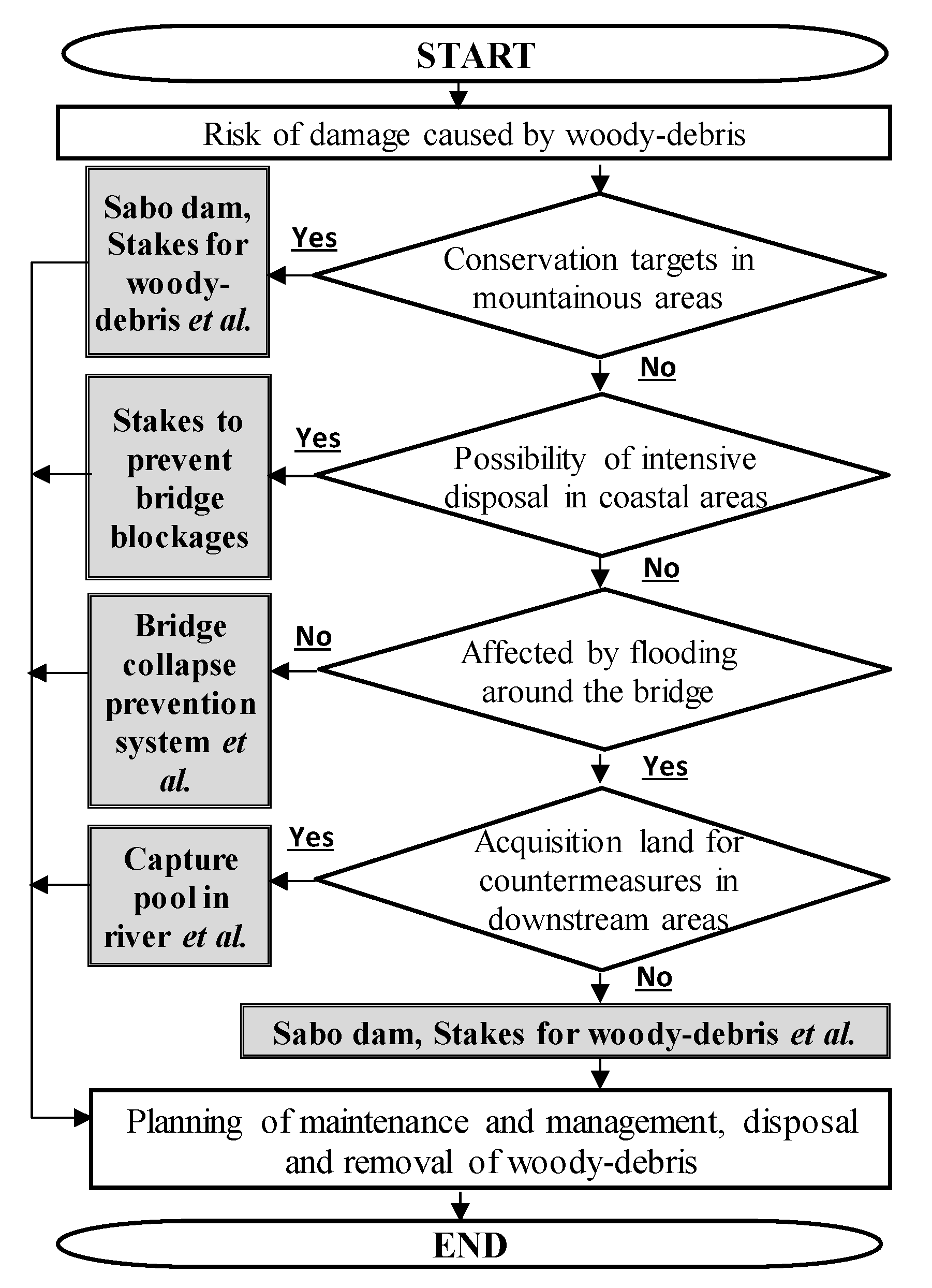
Figure 28 shows a proposed flowchart for the discussion of woody debris countermeasure policies according to basin characteristics. To effectively promote woody debris countermeasures in river basins from mountains to estuaries, cooperation is needed among forest, sabo dam, river, coast, port/fishing, and road facility management teams. Furthermore, woody debris capture in the backwater part of reservoir dams is effective, and future discussions of rational woody debris countermeasures in this context are desirable.
7. Conclusions
Based on an examination of past damage reports and our previous research, the comprehensive promotion of woody debris countermeasures is important for future river basin management. This study is the first to examine woody debris flow damage at the scale of an entire watershed. We found that it is necessary to consider a wide range of basin areas, from mountains to coastal areas. In this context, we proposed a new study flow for implementing effective measures against woody debris damage throughout an entire watershed. Changes in riverbed longitudinal slope were found to be important for effective woody debris-trapping piles, and an upstream/downstream slope ratio of ≥30 was optimal.
Author Contributions
Writing—original draft preparation, N.H.; supervision, T.M.; writing—review and editing, Y.S.; project administration, I.K. All authors have read and agreed to the published version of the manuscript.
Funding
This work was supported by JSPS KAKENHI grants: Grant-in-Aid for Scientific Research (B) (grant number JP22H01578).
Institutional Review Board Statement
Not applicable.
Data Availability Statement
Not applicable.
Conflicts of Interest
The authors declare no conflict of interest.
References
- IPCC: 6th Assessment Report. Climate Change. 2021. Available online: https://unfccc.int/topics/science/workstreams/cooperation-with-the-ipcc/the-sixth-assessment-report-of-the-ipcc?gclid=CjwKCAjw0N6hBhAUEiwAXab-TdqydZlV1F0U42n0nKRSM5UbYbUraglBN15RhGdaFnIrH8lNiOt5hhoCFy4QAvD_BwE (accessed on 1 December 2022).
- INTERPRAEVENT. Wildholz Praxisleitfaden. 2011. Available online: http://www.interpraevent.at/palm-cms/upload_files/Publikationen/Handbooks/Wildholz_2011.pdf (accessed on 1 December 2022).
- Ishikawa, Y. Research on Disasters Caused by Sediment Runoff Accompanied by Driftwood from Small Mountain Streams. Ph.D. Thesis, Kyoto University, Kyoto, Japan, 1990. [Google Scholar]
- Miao, F.; Zhao, F.; Wu, Y.; Li, L.; Xue, Y.; Meng, J. A novel seepage device and ring-shear test on slip zone soils of landslide in the three gorges reservoir area. Eng. Geol. 2022, 307, 106779. [Google Scholar] [CrossRef]
- Miao, F.; Zhao, F.; Wu, Y.; Li, L.; Török, Á. Landslide susceptibility mapping in three gorges reservoir area based on GIS and boosting decision tree model. Stoch. Environ. Res. Risk Assess. 2023. [Google Scholar] [CrossRef]
- Wohl, E.E.; Goode, J.R. Wood dynamics in headwater streams of the Colorado Rocky Mountains. Water Resour. Res. 2008, 44, W09429. [Google Scholar] [CrossRef]
- Seo, J.I.; Nakamura, F. Scale-dependent controls upon the fluvial export of large wood from river catchments. Earth Surf. Process Landf. 2009, 34, 786–800. [Google Scholar] [CrossRef]
- Suzuki, K.; Shinohara, A.; Moriya, H.; Akamatsu, Y. Breach and flood of yamanokami irrigation pond in asakura city, fukuoka prefecture due to 2017 northern kyushu flood. Annu. J. Hydraul. Eng. JSCE 2018, 74, 1183–1186. [Google Scholar] [CrossRef]
- Izumi, A.; Hori, T.; Shosa, D. Disaster cause of small earth fill dam damaged by Northern Kyusyu torrential rain in July 2017. Bull. Natl. Inst. Rural. Eng. 2018, 2, 121–136. [Google Scholar]
- Bezzola, G.R.; Sigg, H.; Lange, D. Driftwood retention works in Switzerland. Int. Symp. Interpraevent 2004, 3, 29–40. [Google Scholar]
- Uchiogi, T.; Shima, J.; Tajima, H.; Ishikawa, Y. Design methods for wood-debris entrapment. Int. Symp. Interpraevent 1996, 5, 279–288. [Google Scholar]
- Fujimura, N.; Kuroiwa, T.; Izumiyama, H.; Akazawa, H.; Mizuno, H. Report on Experimental Analysis of Driftwood Release and Trapping by Closed Type Sabo Dam; Technical Note of PWRI; PWRI: Tsukuba, Japan, 2016; Volume 4331. [Google Scholar]
- SABO. Manual of Technical Standard for Establishing Sabo Master Plan for Debris Flow and Driftwood; Japanese Ministry of Land, Infrastructure and Transport: Tokyo, Japan, 2016.
- SABO. Japan Implementation of Woody-Debris Measures–Immediate Response; Japanese Ministry of Land, Infrastructure and Transport: Tokyo, Japan, 2015.
- Japan Geotechnical Society. Northern Kyushu Torrential Rain Disaster in July 2017 Research Report; Japan Geotechnical Society: Kyoto, Japan, 2017. [Google Scholar]
- Japanese Ministry of Land, Infrastructure and Transport. Available online: http://www.mlit.go.jp/river/sabo/h29_kyushu_gouu/ (accessed on 1 December 2022).
- Japanese Ministry of Land, Infrastructure and Transport. SABO. Available online: http://www.mlit.go.jp/mizukokudo/sabo (accessed on 1 December 2022).
- Schmocker, L.; Weitbrecht, V. Driftwood risk analysis and engineering measures. J. Hydraul. Eng. 2013, 139, 683–695. [Google Scholar] [CrossRef]
- Sekizawa, M.; Sasaki, M.; Matsuda, K.; Ichikawa, M.; Ishihara, M. Maintenance management technology of river and river structures. Advandces River Eng. JSCE 2005, 11, 13–18. [Google Scholar]
- Harada, N.; Takayama, S.; Satofuka, Y.; Mizuyama, T.; Nakatani, K. Fundamental experiment using steel stakes to capture driftwood on an impermeable type sabo dam. Annu. J. Hydraul. Eng. JSCE 2017, 73, 1351–1356. [Google Scholar] [CrossRef] [PubMed]
- Harada, N.; Takayama, S.; Satofuka, Y.; Mizuyama, T.; Nakatani, K. Proposal for a countermeasure against driftwood using steel stakes on impermeable-type sabo dams. Annu. J. Hydraul. Eng. JSCE 2018, 74, 1219–1224. [Google Scholar] [CrossRef]
- Harada, N.; Naito, S.; Satofuka, Y.; Mizuyama, T.; Kosugi, K. Fundamental experiment using stakes to prevent bridge blockages caused by driftwood and natural debris. Annu. J. Hydraul. Eng. JSCE 2016, 72, 301–306. [Google Scholar]
- Harada, N.; Nakatani, K.; Kimura, I.; Satofuka, Y.; Mizuyama. Debris-wood capture effect controlled by concrete-slit dam under low-gradient flow. J. JSCE 2020, 8, 255–260. [Google Scholar] [CrossRef]
- Montgomery, D.R.; Piégay, H. Interactions between wood and channel forms and processes. Geomorphology 2003, 51, 1–5. [Google Scholar] [CrossRef]
- Morita, M.; Tanaka, S.; Takahashi, Y. Investigation of the driftwood by the flood in september 2000. Adv. River Eng. JSCE 2002, 8, 231–236. [Google Scholar]
- Motohiro, S.; Fukuda, K.; Otsuka, Y.; Akaishi, M. Tensile strength of tree roots classified by the pot of root. JSCE Annu. Meet. 2002, 7-015, 29–30. [Google Scholar]
- Tsutsumi, T. Bibliographic Information, 10; Buneidou Publishing: Beijing, China, 1994; pp. 5–10. [Google Scholar]
- Tange, K. Eco Physiological Study on the Growth of Cryptomeria Japonica Planted Trees. Ph.D. Thesis, Tokyo University, Tokyo, Japan, 1993. [Google Scholar]
- Sakou, K.; Suda, T.; Satomi, T.; Fukagawa, R.; Kitamura, R. Experimental study on collapse of Masado slope due to rainfall using indoor soil tank test apparatus. JSCE Annu. Meet. 2005, 60, 3–188. [Google Scholar]
- Sakano, A. Hydraulic Study on Accumulation of Drifting Wood at a Bridge during a Flood; Technical Note of NILIM; NILIM: Tokyo, Japan, 2003; Volume 78. [Google Scholar]
- Ishikawa, Y.; Mizuyama, T.; Fukuzawa, M. Driftwood flowing down in an alluvial fan. Civ. Eng. J. 1991, 33, 38–44. [Google Scholar]
- Okamoto, A. Countermeasures against sediment disasters that occurred in Ehime Prefecture in 2004. Sabo Symp. JSEC 2005, 37, 73–90. [Google Scholar]
- Ito, K.; Suga, K.; Ikeda, H. Practical consideration on bank erosion and channel shift by a big flood of low frequency in the Yosasa river. Annu. J. Hydraul. Eng. JSCE 2001, 45, 781–786. [Google Scholar] [CrossRef]
- Fire and Disaster Management Agency; Ministry of Internal Affairs and Communications. Damage Caused by Typhoon No. 14 and Heavy Rain in 2005; Fire and Disaster Management Agency; Ministry of Internal Affairs and Communications: Tokyo, Japan, 2015.
- Kyushu Electric Power. List of Maximum Inflow and Maximum Discharge of Mimi River Dam; Kyushu Electric Power: Fukuoka, Japan, 2006. [Google Scholar]
- Sato, H.; Nagasaka, Y.; Asai, T.; Teruzawa, K. Quantification of the woody debris in Appetsu river basin by Typhoon 0310, Etau. Jpn. Soc. Eros. Control Eng. 2006, 58, 11–17. [Google Scholar]
- Tamai, N.; Ishino, K.; Bouda, S.; Meno, S.; Watanabe, Y. River Bridge Disasters Caused by Heavy Rain Causes and Counter Measures; Gihodo Publishing: Tokyo, Japan, 2015. [Google Scholar]
- Comprehensive Coastal Flotsam Countermeasure Study Survey; Japanese Ministry of Land, Infrastructure and Transport: Tokyo, Japan, 2003.
- Sato, S. Elucidation of the actual condition of river waste washed ashore on the coast. In River Environment Control Foundation River Environment Integrated Research Place; 2006. [Google Scholar]
- Chaishi, T.; Kikuchi, T.; Maeda, M. Accumulation of sediments in a reservoir and its countermeasures “A Case Study of SAKUMA Dam”. J. Jpn. Soc. Eng. Geol. 2002, 43, 316–319. [Google Scholar] [CrossRef]
- Varnes, D.J. Slopes movement types and processes. In Landslide Analysis and Control, Special Reports; National Academy of Sciences: Washington, DC, USA, 1978; Volume 176, pp. 11–33. [Google Scholar]
- Abe, K. Slope failure prevention function of forests. J. Jpn. Soc. Reveg. Technol. 1991, 31, 330–337. [Google Scholar] [CrossRef]
- Abe, K. Estimation of shear reinforcement strength by root system pull-out resistance. J. Jpn. Soc. Reveg. Technol. 1991, 16, 37–45. [Google Scholar] [CrossRef] [PubMed]
Figure 1.
Damage caused by woody debris flows. (a) Mountainous area [2]. (b) Coastal area.
Figure 1.
Damage caused by woody debris flows. (a) Mountainous area [2]. (b) Coastal area.

Figure 2.
Woody debris damage following the July 2017 heavy rain disaster in northern Kyushu, Japan. (a) Yamanokami agricultural pond on the Naragaya River before and after the disaster [8,9]. (b) Woody debris capture by the impermeable Myoken River sabo dam after the disaster [16].


Figure 3.
Stakes installed to prevent blockages at Togetsukyo Bridge in Kyoto-Arashiyama, Japan.

Figure 4.
Proportions of tree species in woody debris runoff, obtained by dividing the number of pieces of wood of each species that flowed into Yahagi Dam by its forest area ratio [25].
Figure 4.
Proportions of tree species in woody debris runoff, obtained by dividing the number of pieces of wood of each species that flowed into Yahagi Dam by its forest area ratio [25].

Figure 5.
Relationship between root tensile strength and diameter for identified tree species [26].
Figure 5.
Relationship between root tensile strength and diameter for identified tree species [26].

Figure 6.
Specific gravity values for living trees of various species [30].
Figure 6.
Specific gravity values for living trees of various species [30].

Figure 7.
Maps of the Myoken and Naragaya River basins.

Figure 8.
Flooding at Sugawa sabo dam I.

Figure 9.
Woody debris flow damage immediately upstream of Sugawa sabo dam I.

Figure 10.
Schematic view of woody debris capture at an impermeable sabo dam [3].
Figure 10.
Schematic view of woody debris capture at an impermeable sabo dam [3].

Figure 11.
Cross-sectional view of woody debris capture at an impermeable sabo dam [20].
Figure 11.
Cross-sectional view of woody debris capture at an impermeable sabo dam [20].

Figure 12.
Differences in shear resistance in soil with and without tree roots [43].
Figure 12.
Differences in shear resistance in soil with and without tree roots [43].

Figure 13.
Schematic of sediment and woody debris outflow during a landslide.

Figure 14.
Schematic of woody debris capture by a sabo dam on the Myoken River.

Figure 15.
Japanese bridge collapse prevention measures.

Figure 16.
Stakes installed to prevent woody debris blockages at bridges by controlling the woody debris flow direction [22].
Figure 16.
Stakes installed to prevent woody debris blockages at bridges by controlling the woody debris flow direction [22].

Figure 17.
Woody debris capture mechanism of a concrete slit sabo dam model.

Figure 18.
Plan view of current direction and woody debris behavior on the flooding surface of a concrete slit sabo dam [22].
Figure 18.
Plan view of current direction and woody debris behavior on the flooding surface of a concrete slit sabo dam [22].

Figure 19.
Longitudinal view of current direction and woody debris behavior in the flooding area upstream of the dam [22].
Figure 19.
Longitudinal view of current direction and woody debris behavior in the flooding area upstream of the dam [22].

Figure 20.
Methods for improving woody debris capture in an impermeable sabo dam [20].
Figure 20.
Methods for improving woody debris capture in an impermeable sabo dam [20].

Figure 21.
Experiment of the woody debris capture function of a partially permeable sabo dam [20].
Figure 21.
Experiment of the woody debris capture function of a partially permeable sabo dam [20].

Figure 22.
Woody debris rotation mechanism in running water.

Figure 23.
Proposed woody debris countermeasure at a valley exit.

Figure 24.
Experimental waterway.

Figure 25.
Driftwood rotational effects.

Figure 26.
Experimental results for a woody debris countermeasure considering terrain characteristics.
Figure 26.
Experimental results for a woody debris countermeasure considering terrain characteristics.

Figure 27.
Woody debris countermeasure based on basin and woody debris flow characteristics.

Figure 28.
Proposed flowchart for a woody debris countermeasure policy discussion.


Table 1.
Major damage caused by woody debris in various parts of river basins in Japan.
| Basin Area | Major Woody Debris Damage | Key Example | |
|---|---|---|---|
| Mountain forest | Slope/mountain stream | Collision with houses | 1988 Hiroshima [31] 2004 Ehime [32] |
| Upstream flooding associated with river channel blockage | 1998 Naka River [33] 2005 Miyazaki [34] | ||
| Reservoir/agricultural pond | Embankment collapse due to spillway blockage | 2005 Miyazaki [35] 2017 Fukuoka [9] | |
| Disposal/removal of outflowing woody debris | 2003 Hokkaido [36] | ||
| Alluvial plain | Slow-flowing river channel | Bridges and culvert blockage | 1998 Naka River [33] 2007 Tama River [37] |
| Other | |||
| Coastal area | Fishing port/harbor | Negative impacts on fishing activity | 2003 Shizuoka [38] |
| Coast | Usage limit by woody debris deposition | 2005 Shizuoka [39] | |
Table 2.
Sedimentation amounts and woody debris capture at sabo dams in the Myoken and Naragaya River basins.
Table 2.
Sedimentation amounts and woody debris capture at sabo dams in the Myoken and Naragaya River basins.
| Myoken River | Naragaya River | ||||
|---|---|---|---|---|---|
| Sugawa-1st Sabo Dam | 2nd Sabo Dam | 3rd Sabo Dam | 1st Sabo Dam | 2nd Sabo Dam | |
| Woody debris capture | Captured | Non-captured | |||
| Deposited sand (before) | Some sediment (<<100%) | Somes ediment | Full sediment | ||
| Deposited sand (after) | Some sediment | Full sediment >> 100% | |||
| Stream slope (after) | ~1/25 | ~1/20 | ~1/15 | ~1/15 | ~1/15 |
| Dam height (m) | 8 | 10 | 10 | 8 | 6 |
| Dam length (m) | 75 | 50 | 65 | 50 | 30 |
| Water outflow width of dam (m) | 8 | 5 | 2 | 4 | 4 |
| Dam type | Impermeable sabo dam | ||||
| Basin area (km2) | 1.8 | 1.2 | |||
| Geology | Mafic schist | Pelitic schist | |||
| Dominant tree taxa | Cedar, cypress, et al. | ||||
Table 3.
Main woody debris countermeasures in various parts of river basins in Japan.
| Countermeasure | Purpose | Key Notes | |
|---|---|---|---|
| Slope/mountain stream | Hillside excavation | Landslide prevention | Countermeasures required in all sediment production areas Coordination with land owners required |
| Sabo dam with steel fittings | Sediment and woody debris capture | Maintenance requires stone and tree removal All mountain streams require countermeasures | |
| River | Piles and nets | Woody debris capture and sediment slowing | Maintenance requires continual tree removal Large amounts of land must be secured to install countermeasures |
| Bridge | Submersible/subsidence bridge | Woody debris blockage reduction | Bridge structure safety must be confirmed after flooding; traffic must be regulated |
| Stakes | Collision and blockage prevention | Maintenance requires garbage removal | |
| Bridge girder chains | Prevention of bridge movement | May promote woody debris blockage at the bridge, increasing flood risk |
Table 4.
Experimental conditions.
| CASE | qin (L/s) | φ1 (mm) | θw (deg.) | θp (deg.) | Lw (m) | Lp (m) |
|---|---|---|---|---|---|---|
| 1-1 | 0.25 | 1.6 | 15 | 2.0 | 1.0 | 1.0 |
| 1-2 | 0.80 | |||||
| 1-3 | 0.50 | |||||
| 1-4 | 2.0 | |||||
| 1-5 | 2.8 | |||||
| 1-6 | 1.8 | 1.0 | ||||
| 1-7 | 3.0 | |||||
| 1-8 | 0.5 | |||||
| 1-9 | 2 | 2.0 | ||||
| 2-1 | 0.5 | 1.0 | ||||
| 2-2 | 2.0 | 2.0 | ||||
| 2-3 | 0.80 | 2.8 | 1.0 | 1.0 | ||
| 2-4 | 0.50 | 1.6 | 10 | 0.5 |
Disclaimer/Publisher’s Note: The statements, opinions and data contained in all publications are solely those of the individual author(s) and contributor(s) and not of MDPI and/or the editor(s). MDPI and/or the editor(s) disclaim responsibility for any injury to people or property resulting from any ideas, methods, instructions or products referred to in the content. |
© 2023 by the authors. Licensee MDPI, Basel, Switzerland. This article is an open access article distributed under the terms and conditions of the Creative Commons Attribution (CC BY) license (https://creativecommons.org/licenses/by/4.0/).
Share and Cite
MDPI and ACS Style
Harada, N.; Kimura, I.; Satofuka, Y.; Mizuyama, T. Proposed Countermeasures against Woody Debris Damage Considering Runoff Characteristics. Water 2023, 15, 1588. https://doi.org/10.3390/w15081588
AMA Style
Harada N, Kimura I, Satofuka Y, Mizuyama T. Proposed Countermeasures against Woody Debris Damage Considering Runoff Characteristics. Water. 2023; 15(8):1588. https://doi.org/10.3390/w15081588
Chicago/Turabian StyleHarada, Norio, Ichiro Kimura, Yoshifumi Satofuka, and Takahisa Mizuyama. 2023. "Proposed Countermeasures against Woody Debris Damage Considering Runoff Characteristics" Water 15, no. 8: 1588. https://doi.org/10.3390/w15081588
Note that from the first issue of 2016, this journal uses article numbers instead of page numbers. See further details here.