
Fluvial Responses to Late Quaternary Climate Change in a Humid and Semi-Humid Transitional Area: Insights from the Upper Huaihe River, Eastern China
 ,
,
Abstract
:1. Introduction
2. Study Area
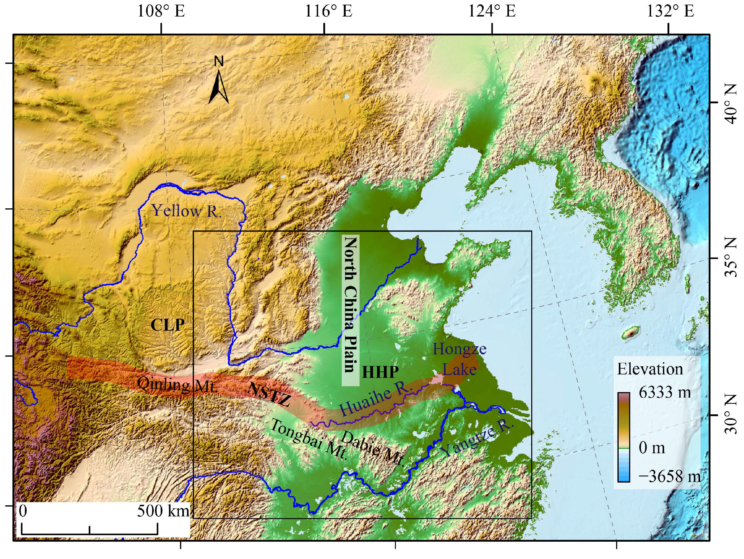
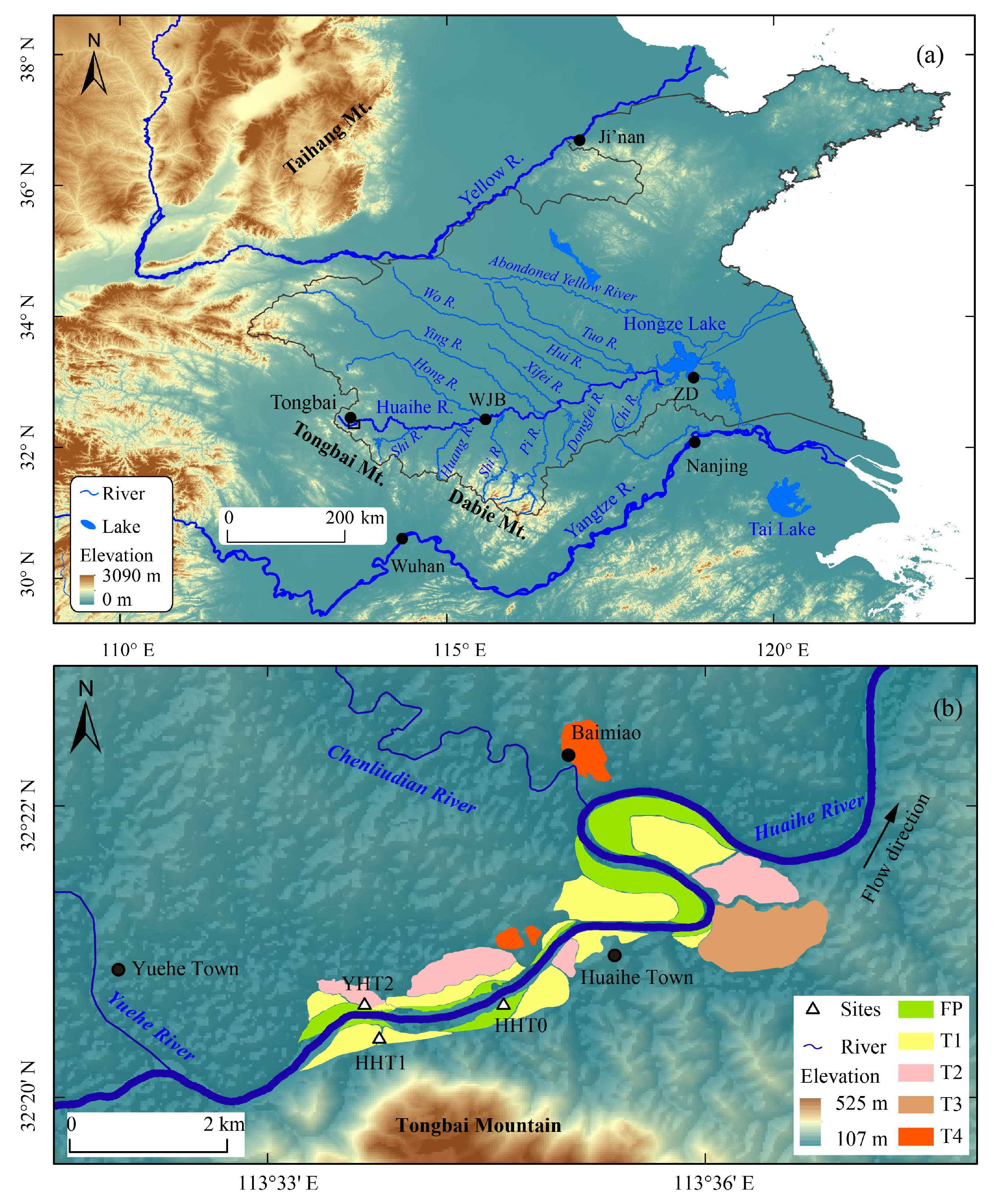
2.1. Geographic Settings
2.2. Paleoclimates

| MIS | Upper HHR Basin | Middle HHR Basin | Lower HHR Basin | |||
|---|---|---|---|---|---|---|
| Huzupu [33] | Xiangcheng [45] | Yuzhou [32] | Yinzhuangqiao [47] | Zhoufen [36] | Shagou [37] | |
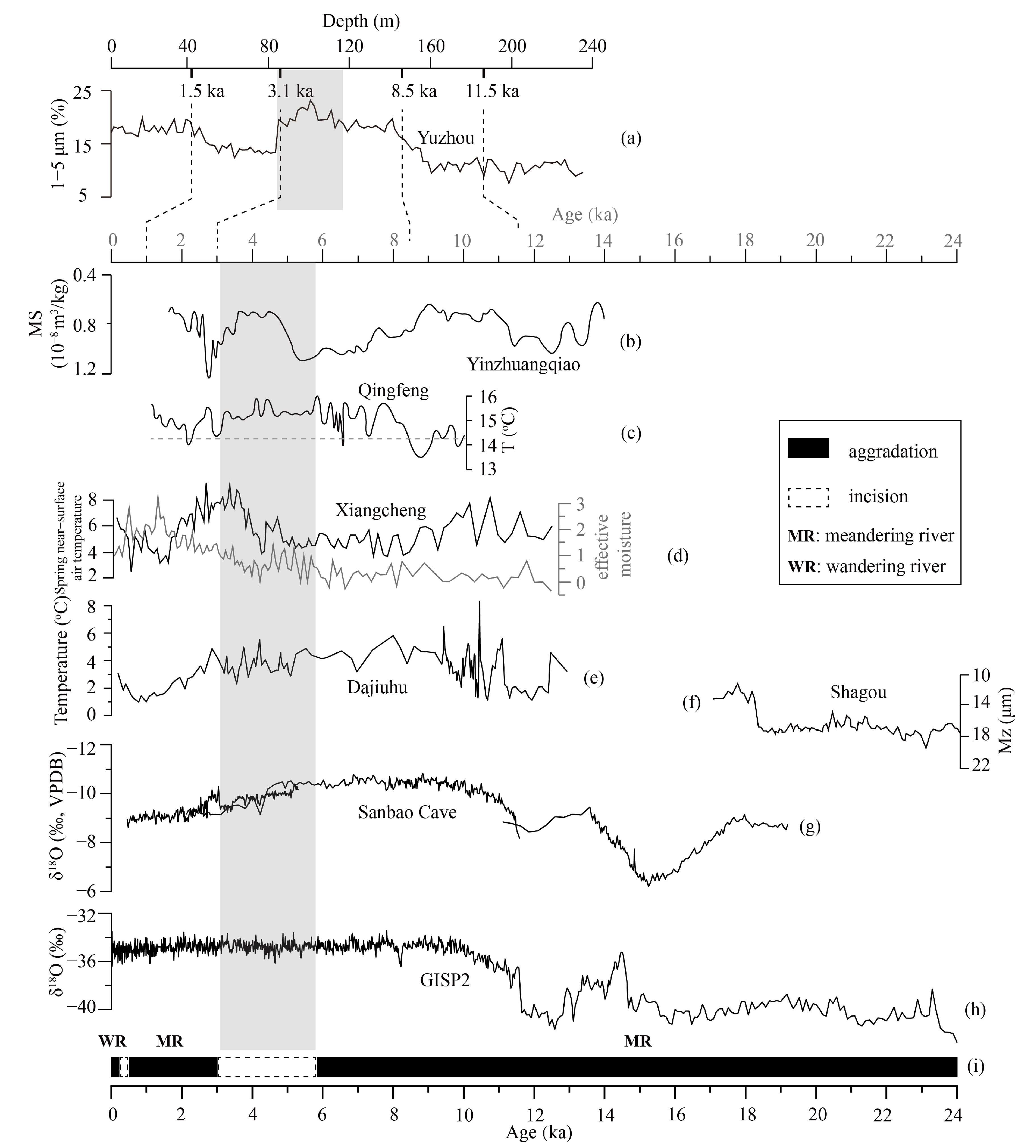
| 1 | Warm–wet (since 13 ka) | Cold–wet to warm–dry (since 1.8 ka) Warm–wet (3.8–1.8 ka) Cold–dry (4.5–3.8 ka) Cold–wet (5.8–4.5 ka) Warm to cold–dry (12.1–5.8 ka) | Cold–dry (since 3.1 ka) Warm–wet (8.5–3.1 ka) Warming and wetting (11.5–8.5 ka) | Warm–wet (5–1.5 ka) Cooling and drying (7.5–5 ka) Warm–wet (11.3–7.5 ka) | ||
| 2 | Warm–dry to warm–wet (25–13 ka) Warm–wet (30–25 ka) | Cold–dry (13–11.3 ka) Warm–wet (14.2–13 ka) Cold–dry (19.2–14.2 ka) | Cold–dry (30–18.6 ka) | Warm-wet (18–15 ka) Dry (26–18 ka) Wet (30–26 ka) | ||
| 3 | Wet (40–30 ka) | |||||
3. Sampling and Methodology
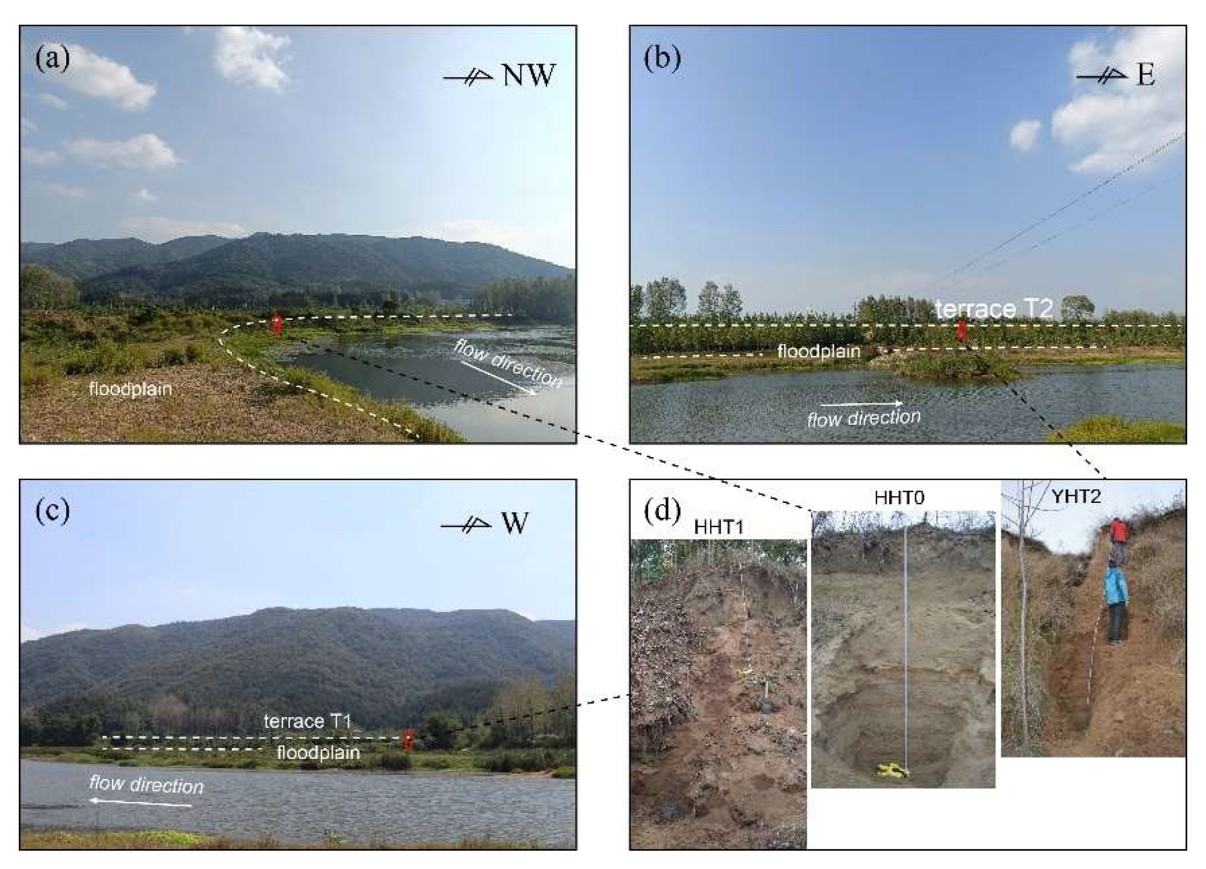
3.1. Fieldwork
3.2. Grain Size
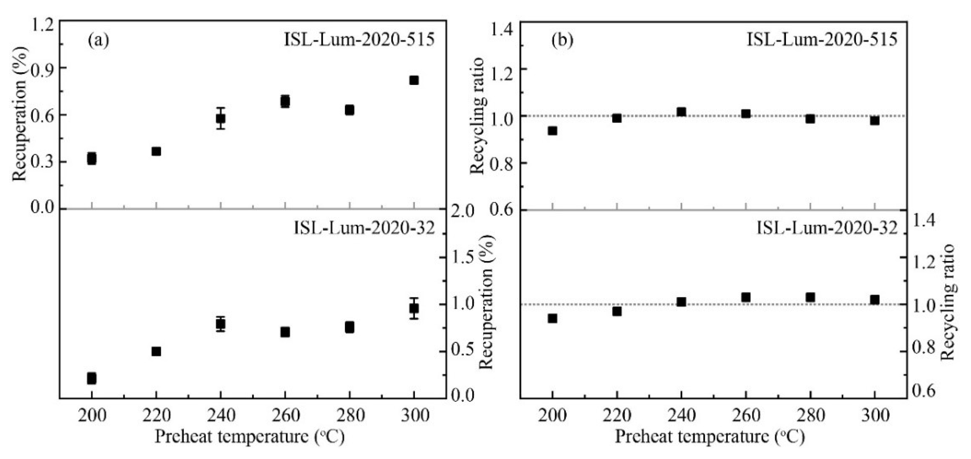
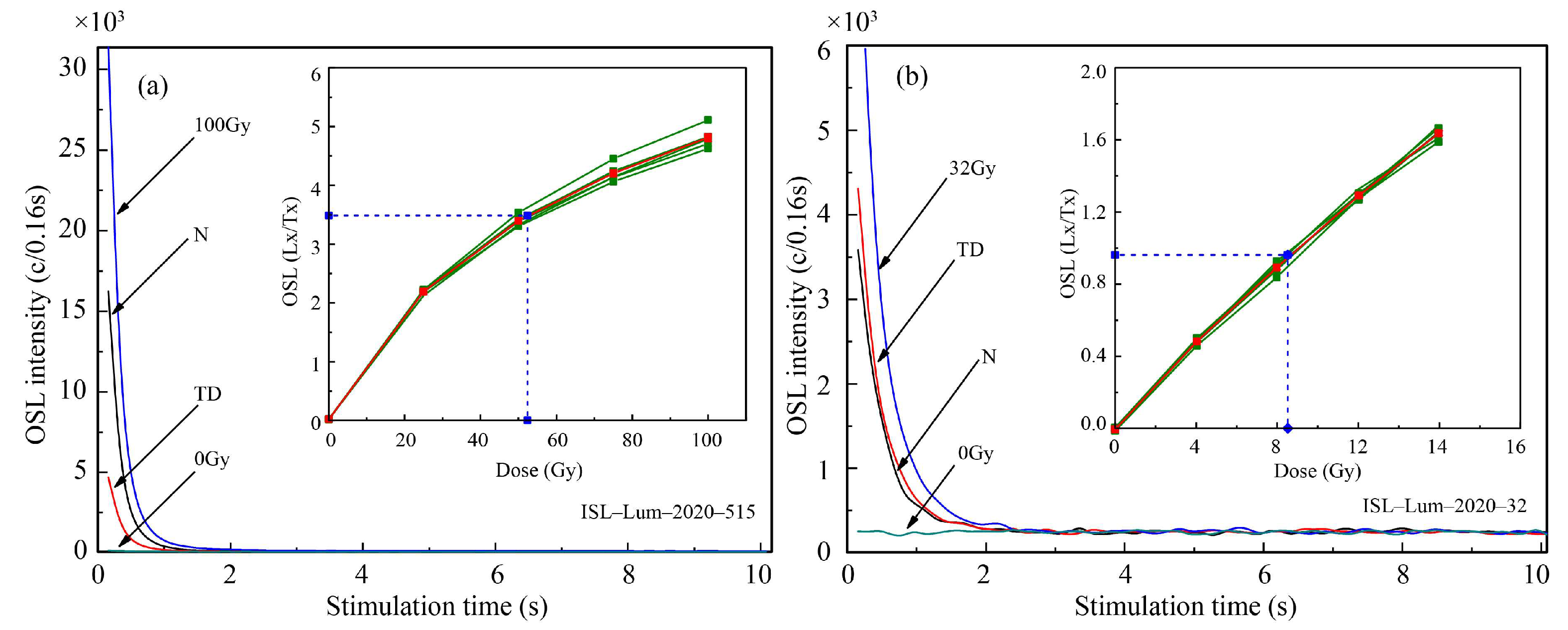
3.3. Dating Methods
4. Results
4.1. Stratigraphy
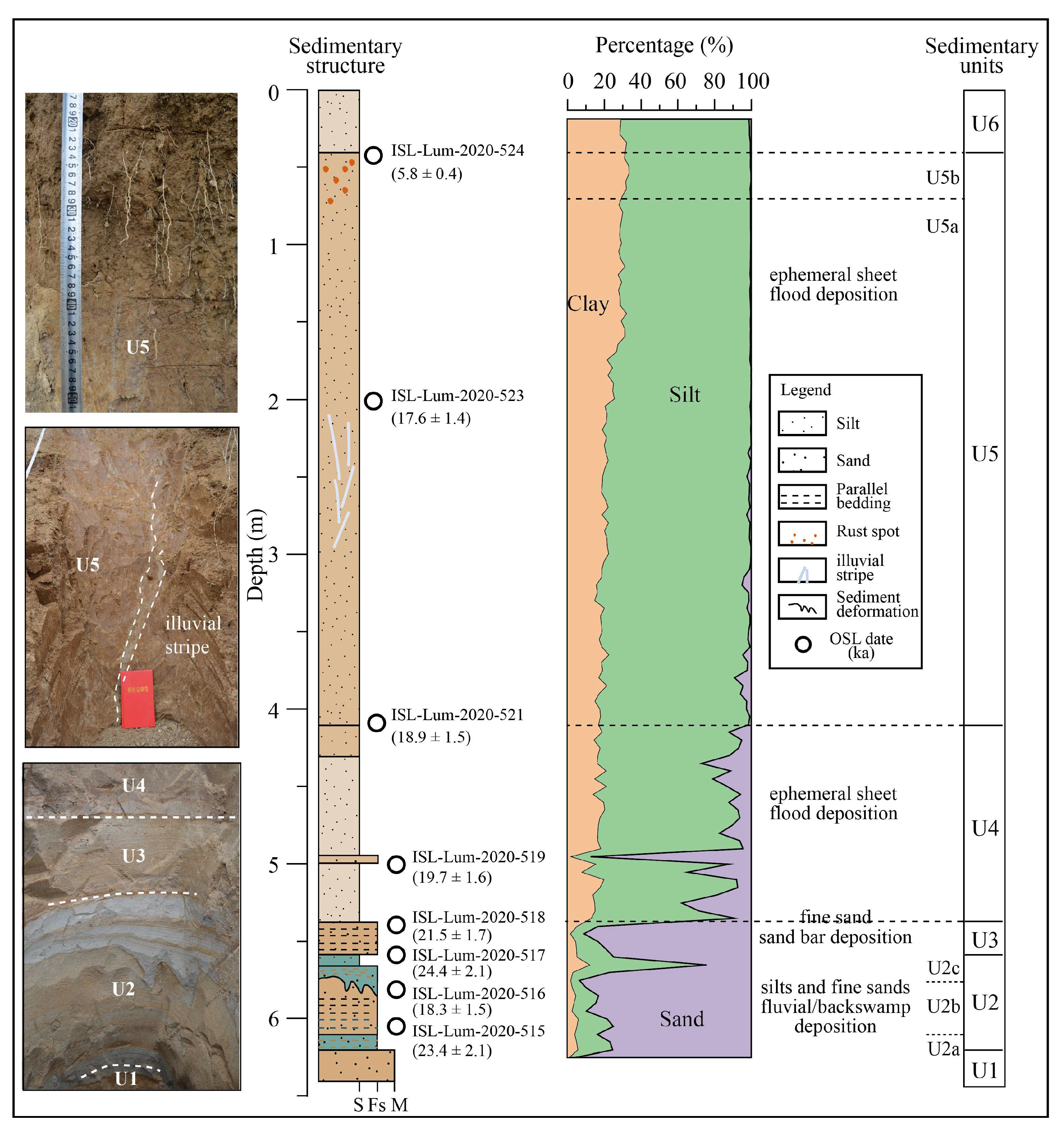
4.1.1. YHT2 Outcrop
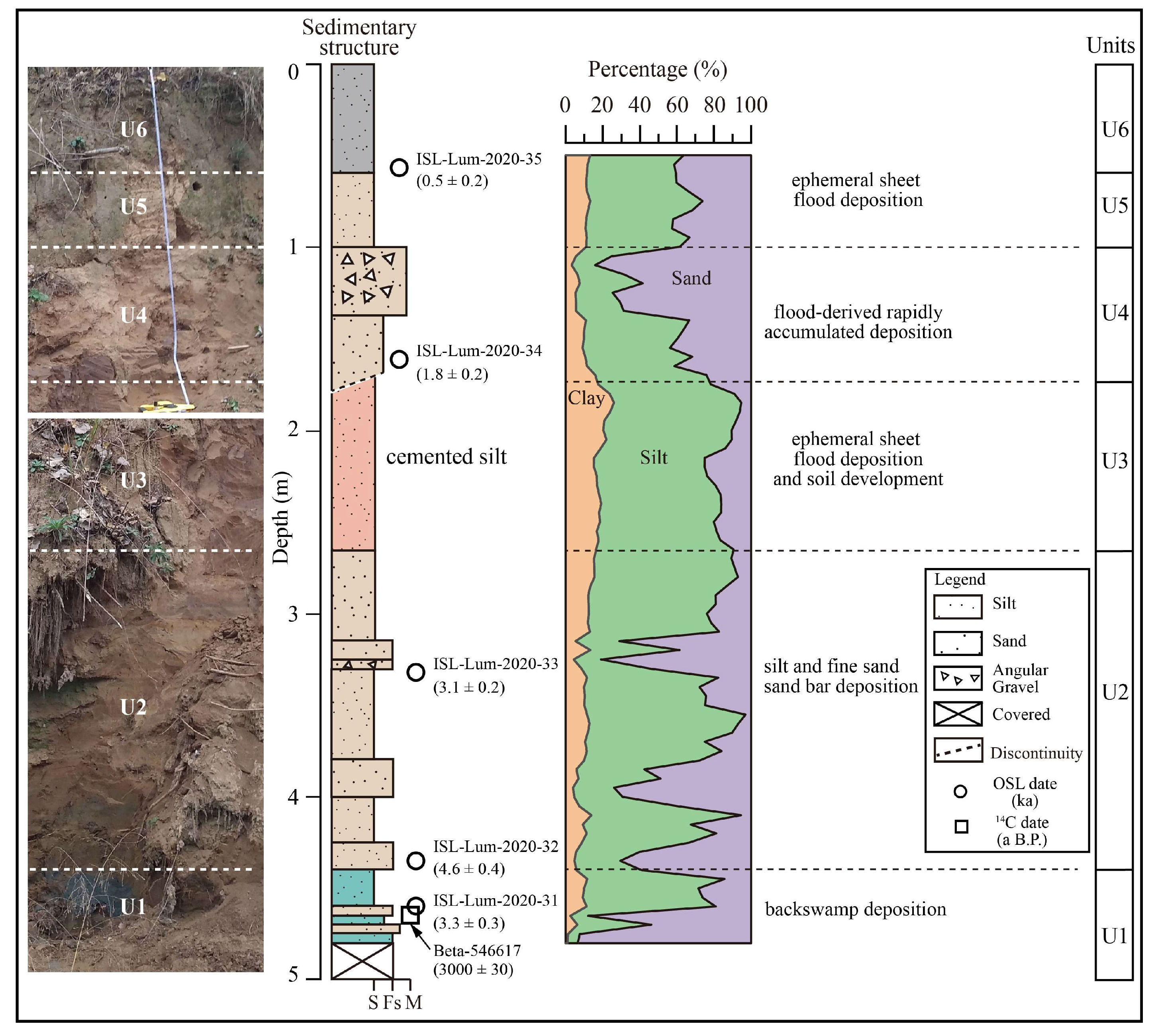
4.1.2. HHT1 Outcrop
4.1.3. HHT0 Outcrop
4.2. Dating Results
5. Discussion
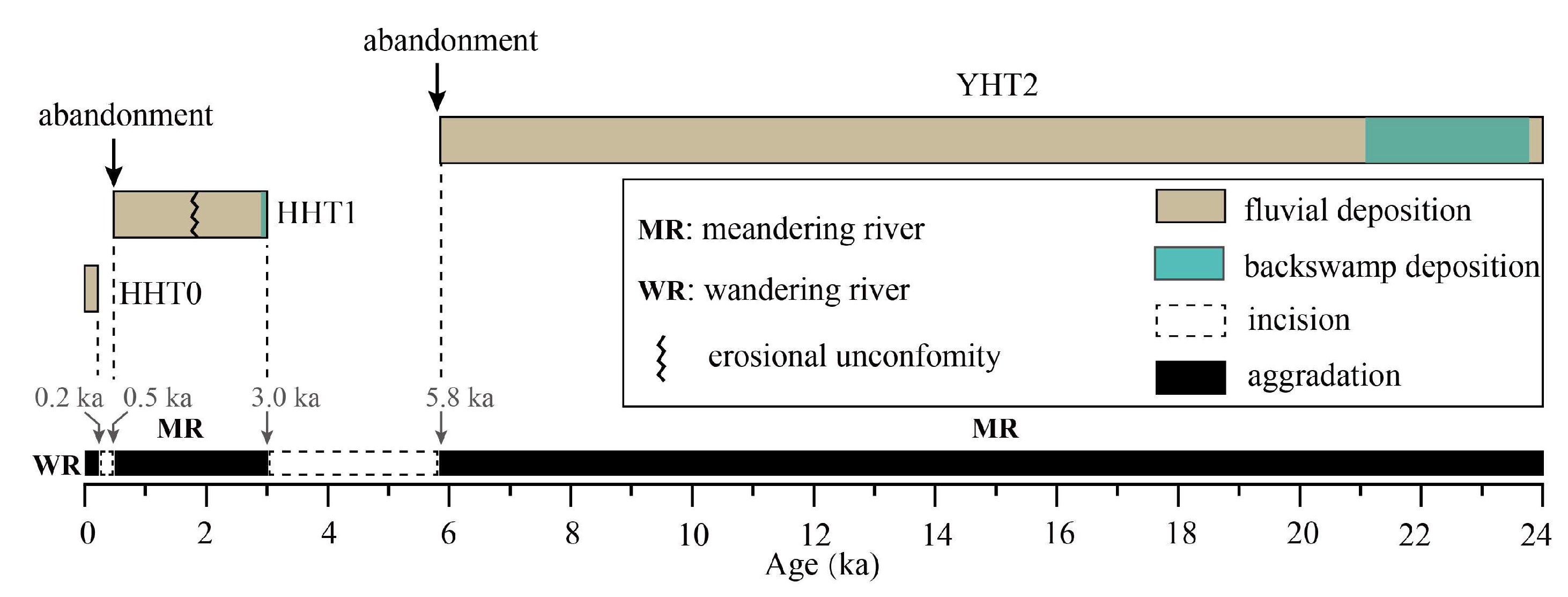
5.1. Late Quaternary Fluvial Processes in the Upper HHR
5.2. Fluvial Responses to Climate Change in the Upper HHR
5.3. Regional Differentiation
6. Conclusions
Author Contributions
Funding
Data Availability Statement
Conflicts of Interest
References
- Bull, W.B. Geomorphic Responses to Climatic Change; Oxford University Press: New York, NY, USA, 1991. [Google Scholar]
- Pan, B.T.; Su, H.; Hu, Z.B.; Hu, X.F.; Gao, H.S.; Li, J.J.; Kirby, E. Evaluating the role of climate and tectonics during non-steady incision of the Yellow River: Evidence from a 1.24 Ma terrace record near Lanzhou, China. Quat. Sci. Rev. 2009, 28, 3281–3290. [Google Scholar] [CrossRef]
- Bridgland, D.R.; Westaway, R. Quaternary fluvial archives and landscape evolution: A global synthesis. Proc. Geol. Assoc. 2014, 125, 600–629. [Google Scholar] [CrossRef]
- Vandenberghe, J. River terraces as a response to climatic forcing: Formation processes, sedimentary characteristics and sites for human occupation. Quat. Int. 2015, 370, 3–11. [Google Scholar] [CrossRef]
- Cordier, S.; Adamson, K.; Delmas, M.; Calvet, M.; Harmand, D. Of ice and water: Quaternary fluvial response to glacial forcing. Quat. Sci. Rev. 2017, 166, 57–73. [Google Scholar] [CrossRef]
- Gao, H.S.; Li, Z.M.; Liu, F.L.; Wu, Y.J.; Li, P.; Zhao, X.; Li, F.Q.; Guo, J.; Liu, C.R.; Pan, B.T.; et al. Terrace formation and river valley development along the lower Taohe River in central China. Geomorphology 2020, 348, 106885. [Google Scholar] [CrossRef]
- Maddy, D.; Veldkamp, A.; Demir, T.; Aytaç, A.S.; Schoorl, J.M.; Scaife, R.; Boomer, I.; Stemerdink, C.; van der Schriek, T.; Aksay, S.; et al. Early Pleistocene River Terraces of the Gediz River, Turkey: The role of faulting, fracturing, volcanism and travertines in their genesis. Geomorphology 2020, 358, 107102. [Google Scholar] [CrossRef]
- Vandenberghe, J.; Yang, X.; Wang, X.Y.; Wang, S.J.; Lu, H.Y. Diverse floodplain deposits of reworked loess in a monsoon climate (Hanzhong Basin, central China). Quat. Res. 2021, 103, 4–20. [Google Scholar] [CrossRef]
- Yu, Y.; Wang, X.Y.; Yi, S.W.; Miao, X.D.; Vandenberghe, J.; Li, Y.Q.; Lu, H.Y. Late Quaternary aggradation and incision in the headwaters of the Yangtze River, eastern Tibetan Plateau, China. Geol. Soc. Am. Bull. 2022, 134, 371–388. [Google Scholar] [CrossRef]
- Schumm, S.A. The Fluvial System; John Wiley: New York, NY, USA, 1977. [Google Scholar]
- Vandenberghe, J. The fluvial cycle at cold–warm–cold transitions in lowland regions: A refinement of theory. Geomorphology 2008, 98, 275–284. [Google Scholar] [CrossRef]
- Larkin, Z.T.; Ralph, T.J.; Tooth, S.; Duller, G.A.T. A shifting ‘river of sand’: The profound response of Australia’s Warrego River to Holocene hydroclimatic change. Geomorphology 2020, 370, 107385. [Google Scholar] [CrossRef]
- Tao, Y.L.; Xiong, J.G.; Zhang, H.P.; Chang, H.; Li, L.Y. Climate-driven formation of fluvial terraces across the Tibetan Plateau since 200 ka: A review. Quat. Sci. Rev. 2020, 237, 106303. [Google Scholar] [CrossRef]
- Gao, H.S.; Li, Z.M.; Liu, X.F.; Pan, B.T.; Wu, Y.J.; Liu, F.L. Fluvial terraces and their implications for Weihe River valley evolution in the Sanyangchuan Basin. Sci. China Earth Sci. 2017, 60, 413–427. [Google Scholar] [CrossRef]
- Maddy, D.; Veldkamp, A.; Demir, T.; van Gorp, W.; Wijbrans, J.R.; van Hinsbergen, D.J.J.; Dekkers, M.J.; Schreve, D.; Schoorl, J.M.; Scaife, R.; et al. The Gediz River fluvial archive: A benchmark for Quaternary research in Western Anatolia. Quat. Sci. Rev. 2017, 166, 289–306. [Google Scholar] [CrossRef]
- Wang, X.Y.; Vandenberghe, J.; Lu, H.Y.; Van Balen, R. Climatic and tectonic controls on the fluvial morphology of the Northeastern Tibetan Plateau (China). J. Geogr. Sci. 2017, 27, 1325–1340. [Google Scholar] [CrossRef]
- Gao, H.S.; Li, Z.M.; Pan, B.T.; Liu, F.L.; Liu, X.P. Fluvial responses to late Quaternary climate change in the Shiyang River drainage system, western China. Geomorphology 2016, 258, 82–94. [Google Scholar] [CrossRef]
- Kalicki, T.; Kalicki, P. Fluvial activity in the Lomas de Lachay during the upper Pleistocene and Holocene. Geomorphology 2020, 357, 107087. [Google Scholar] [CrossRef]
- Sinha, R.; Singh, A.; Tandon, S.K. Fluvial archives of north and northwestern India as recorders of climatic signatures in the late Quaternary: Review and assessment. Curr. Sci. India 2020, 119, 232–243. [Google Scholar] [CrossRef]
- Knox, J.C. Valley alluviation in Southwestern Wisconsin. Ann. Assoc. Am. Geogr. 1972, 62, 401–410. [Google Scholar] [CrossRef]
- Vandenberghe, J. Time scales, climate and river development. Quat. Sci. Rev. 1995, 14, 631–638. [Google Scholar] [CrossRef]
- Blum, M.D.; Toomey III, R.S.; Valastro, S., Jr. Fluvial response to Late Quaternary climatic and environmental change, Edwards Plateau, Texas. Palaeogeogr. Palaeoclimatol. Palaeoecol. 1994, 108, 1–21. [Google Scholar] [CrossRef]
- Knox, J.C. Late Quaternary Upper Mississippi River alluvial episodes and their significance to the Lower Mississippi River system. Eng. Geol. 1996, 45, 263–285. [Google Scholar] [CrossRef]
- Wang, X.Y.; Vandenberghe, J.; Yi, S.W.; Van Balen, R.; Lu, H.Y. Climate-dependent fluvial architecture and processes on a suborbital timescale in areas of rapid tectonic uplift: An example from the NE Tibetan Plateau. Glob. Planet. Change 2015, 133, 318–329. [Google Scholar] [CrossRef]
- Xu, L.X.; Ran, Y.K.; Liu, H.G.; Li, A. 10Be-derived sub-Milankovitch chronology of Late Pleistocene alluvial terraces along the piedmont of SW Tian Shan. Geomorphology 2019, 328, 173–182. [Google Scholar] [CrossRef]
- Jain, M.; Tandon, S.K. Fluvial response to Late Quaternary climate changes, western India. Quat. Sci. Rev. 2003, 22, 2223–2235. [Google Scholar] [CrossRef]
- Zheng, J.Y.; Yin, Y.H.; Li, B.Y. A new scheme for climate regionalization in China. Acta. Geogr. Sin. 2010, 65, 3–12. (In Chinese) [Google Scholar]
- Zhang, B.P. Ten major scientific issues concerning the study of China’s North-South Transitional Zone. Progr. Geogr. 2019, 38, 305–311. (In Chinese) [Google Scholar]
- Ning, Y.; Qian, M.; Wang, Y.T. Hydrology Handbook of the Huaihe River Drainage Basin; Science Press: Beijing, China, 2003. (In Chinese) [Google Scholar]
- Xu, J.X. Morphological analysis of flood of the Huai River. J. Catastrophol. 1992, 7, 45–50. (In Chinese) [Google Scholar]
- Zhao, X.T.; Tang, L.Y.; Shen, C.M.; Wang, S.H. Climate evolution and sea level changes based on Qingfeng Section, Jianhu, Jiangsu. Acta Oceanol. Sin. 1994, 16, 78–88. (In Chinese) [Google Scholar]
- Li, X.Y.; Huang, C.C.; Pang, J.L.; He, Z. Dust source of the Holocene loess soil and pedogenic environmental changes in the upper Huaihe River. J. Geogr. Sci. 2009, 19, 107–117. [Google Scholar] [CrossRef]
- Yang, J.F.; Hou, L.X.; Chao, H.L.; Zeng, X.Y.; Jiao, J.H. Climate and basin evolution in the southwestern Huanghuai Plain from 130 to 13 ka: A case study of the Huzupu profile in Xinyang, Henan Province. Acta Geol. Sin. Henan 2011, 1, 20–25. (In Chinese) [Google Scholar]
- Li, K.F.; Gao, W.H. Holocene climate change in Henan area: A synthesis of proxy records. Quat. Int. 2019, 521, 185–193. [Google Scholar] [CrossRef]
- Li, Z.M.; Zhu, W.M.; Gao, H.S.; Liu, F.L.; Xing, W. Late Cenozoic climate changes in the Huanghuai Plain. Mar. Geol. Quat. Geol. 2021, 41, 179–191. (In Chinese) [Google Scholar]
- Liu, Y.; Yang, P.P.; Shu, Q. Paleoclimatic and paleoenvironmental changes in late stage of late Pleistocene inferred from lacustrine sediment in Subei basin. Earth Env. 2021, 49, 1–8. (In Chinese) [Google Scholar]
- Chen, J.R.; Shu, Q.; Zhao, Z.J.; Zhang, M.H. Climate change records of lacustrine deposits of Subei Basin in eastern China, 30–17 cal ka BP. Geol. Sci. Tech. Inf. 2017, 36, 75–79. (In Chinese) [Google Scholar]
- Stuiver, M.; Grootes, P.M.; Braziunas, T.F. The GISP2 δ18O climate record of the past 16,500 years and the role of the sun, ocean, and volcanoes. Quat. Res. 1995, 44, 341–354. [Google Scholar] [CrossRef]
- Wang, Y.J.; Cheng, H.; Edwards, R.L.; An, Z.S.; Wu, J.Y.; Shen, C.C.; Dorale, J.A. A High-Resolution Absolute-Dated Late Pleistocene Monsoon Record from Hulu Cave, China. Science 2001, 294, 2345–2348. [Google Scholar] [CrossRef]
- Wang, Y.J.; Cheng, H.; Edwards, R.L.; Kong, X.G.; Shao, X.H.; Chen, S.T.; Wu, J.Y.; Jiang, X.Y.; Wang, X.F.; An, Z.S. Millennial- and orbital-scale changes in the East Asian monsoon over the past 224,000 years. Nature 2008, 451, 1090–1093. [Google Scholar] [CrossRef] [PubMed]
- Mao, R.X.; Cai, Y.J.; Ma, L.; Cheng, X. Early to mid-Holocene paleoclimatic changes recorded by the stalagmites from the Magou Cave, Henan Province. J. Earth Env. 2016, 7, 254–268. (In Chinese) [Google Scholar]
- Hao, Z.X.; Zheng, J.Y.; Ge, Q.S.; Zhang, X.Z. Spatial patterns of precipitation anomalies for 30-yr warm periods in China during the past 2000 years. Acta. Meteorol. Sin. 2012, 26, 278–288. [Google Scholar] [CrossRef]
- Chen, J.H.; Chen, F.H.; Feng, S.; Huang, W.; Liu, J.B.; Zhou, A.F. Hydroclimatic changes in China and surroundings during the Medieval Climate Anomaly and Little Ice Age: Spatial patterns and possible mechanisms. Quat. Sci. Rev. 2015, 107, 98–111. [Google Scholar] [CrossRef]
- Zhou, X.C.; Jiang, D.B.; Lang, X.M. A multi-model analysis of ‘Little Ice Age’ climate over China. Holocene 2019, 29, 592–605. [Google Scholar] [CrossRef]
- Qin, X.G.; Zhang, L.; Mu, Y. The Holocene climatic changes of the Huaihe River semi-humid region in the North and South Transition Zone of the eastern China. Quat. Sci. 2015, 35, 1509–1524. (In Chinese) [Google Scholar]
- Shu, Q.; Zhao, Z.J.; Chen, Y.; Zhang, M.H.; Li, J.J. Palaeoenvironmental significance of geochemistry elements and grain size of DS core sediments in Xinghua, Jiangsu Province. Sci. Geogr. Sini. 2009, 29, 923–928. (In Chinese) [Google Scholar]
- Shu, Q.; Chen, Y.; Zhao, Z.J.; Zhang, M.H. Paleoclimatic and paleoenvironmental evolution since the Late Glacial epoch in Jianghuai Plain. Sci. Geogr. Sin. 2013, 33, 1377–1382. (In Chinese) [Google Scholar] [CrossRef]
- Chen, F.H.; Yu, Z.C.; Yang, M.L.; Ito, E.; Wang, S.M.; Madsen, D.B.; Huang, X.Z.; Zhao, Y.; Sato, T.; Birks, H.J.B.; et al. Holocene moisture evolution in arid central Asia and its out-of-phase relationship with Asian monsoon history. Quat. Sci. Rev. 2008, 27, 351–364. [Google Scholar] [CrossRef]
- Chen, F.H.; Jia, J.; Chen, J.H.; Li, G.Q.; Zhang, X.J.; Xie, H.C.; Xia, D.S.; Huang, W.; An, C.B. A persistent Holocene wetting trend in arid central Asia, with wettest conditions in the late Holocene, revealed by multi-proxy analyses of loess-paleosol sequences in Xinjiang, China. Quat. Sci. Rev. 2016, 146, 134–146. [Google Scholar] [CrossRef]
- Yang, X.P.; Liang, P.; Zhang, D.G.; Li, H.W.; Rioual, P.; Wang, X.L.; Xu, B.; Ma, Z.B.; Liu, Q.Q.; Ren, X.Z.; et al. Holocene aeolian stratigraphic sequences in the eastern portion of the desert belt (sand seas and sandy lands) in northern China and their palaeoenvironmental implications. Sci. China Earth Sci. 2019, 62, 1302–1315. [Google Scholar] [CrossRef]
- Reimer, P.J.; Bard, E.; Bayliss, A.; Beck, W.; Blackwell, P.G.; Ramsey, C.B.; Brown, D.M.; Buck, C.E.; Edwards, R.L.; Friedrich, M.; et al. Selection and treatment of data for radiocarbon calibration: An update to the international calibration (INTCAL) criteria. Radiocarbon 2013, 55, 1923–1945. [Google Scholar] [CrossRef]
- Lai, Z.P.; Wintle, A.G. Locating the boundary between the Holocene and Pleistocene In Chinese loess using luminescence. Holocene 2006, 16, 893–899. [Google Scholar] [CrossRef]
- Roberts, H.M. Assessing the effectiveness of the double-SAR protocol in isolating a luminescence signal dominated by quartz. Radiat. Meas. 2007, 42, 1627–1636. [Google Scholar] [CrossRef]
- Murray, A.S.; Wintle, A.G. Luminescence dating of quartz using an improved single-aliquot regenerative-dose protocol. Radiat. Meas. 2000, 32, 57–73. [Google Scholar] [CrossRef]
- Roberts, H.M.; Duller, G.A.T. Standardised growth curves for optical dating of sediment using multiple-grain aliquots. Radiat. Meas. 2004, 38, 241–252. [Google Scholar] [CrossRef]
- Lai, Z.P. Testing the use of an OSL standardised growth curve (SGC) for De de-termination on quartz from the Chinese Loess Plateau. Radiat. Meas. 2006, 41, 9–16. [Google Scholar] [CrossRef]
- Lai, Z.P.; Brückner, H.; Zöller, L.; Fülling, A. Existence of a common growth curve forsilt-sized quartz OSL of loess from different continents. Radiat. Meas. 2007, 42, 1432–1440. [Google Scholar] [CrossRef]
- Prescott, J.R.; Hutton, J.T. Cosmic ray contributions to dose rates for luminescence and ESR dating: Large depths and long-term time variations. Radiat. Meas. 1994, 23, 497–500. [Google Scholar] [CrossRef]
- Singarayer, J.S.; Bailey, R.M. Further investigations of the quartz optically stimulated luminescence components using linear modulation. Radiat. Meas. 2003, 37, 451–458. [Google Scholar] [CrossRef]
- Makaske, B. Anastomosing rivers: A review of their classification, origin and sedimentary products. Earth Sci. Rev. 2001, 53, 149–196. [Google Scholar] [CrossRef]
- Nanson, G.C. Anabranching and Anastomosing Rivers. In Treatise on Geomorphology; Wohl, E., Ed.; Fluvial Geomorphology; Academic Press: San Diego, CA, USA, 2013; Volume 9, pp. 330–345. [Google Scholar]
- Miall, A.D. The Geology of Fluvial Deposits. In Sedimentary Facies, Basin Analysis, and Petroleum Geology; Springer: Berlin/Heidelberg, Germany, 1996. [Google Scholar]
- Wang, X.Y.; Ma, J.F.; Yi, S.W.; Vandenberghe, J.; Dai, Y.; Lu, H.Y. Interaction of fluvial and eolian sedimentation processes, and response to climate change since the last glacial in a semiarid environment along the Yellow River. Quat. Res. 2018, 91, 570–583. [Google Scholar] [CrossRef]
- Huang, X.Y.; Meyers, P.A.; Jia, C.L.; Zheng, M.; Xue, J.T.; Wang, X.X.; Xie, S.C. Paleotemperature variability in central China during the last 13 ka recorded by a novel microbial lipid proxy in the Dajiuhu peat deposit. Holocene 2013, 23, 1123–1129. [Google Scholar] [CrossRef]
- Ge, Q.S.; Zheng, J.Y.; Hao, Z.X.; Shao, X.M.; Wang, W.C.; Luterbacher, J. Temperature variation through 2000 years in China: An uncertainty analysis of reconstruction and regional difference. Geophys. Res. Lett. 2010, 37, L03703. [Google Scholar] [CrossRef]
- Ge, Q.S.; Zheng, J.Y.; Hao, Z.X.; Liu, H.L. General characteristics of climate changes during the past 2000 years in China. Sci. China Earth Sci. 2013, 56, 321–329. [Google Scholar] [CrossRef]
- Ge, Q.S. Climate Change in Chinese Dynasties; Science Press: Beijing, China, 2011. (In Chinese) [Google Scholar]
- Wu, H.; Li, Q.; Yu, Y.; Sun, A.; Lin, Y.; Jiang, W.; Luo, Y. Quantitative climatic reconstruction of the Last Glacial Maximum in China. Sci. China Earth Sci. 2019, 62, 1269–1278. [Google Scholar] [CrossRef]
- Li, M.; Zhang, S.; Xu, Q.; Xiao, J.; Wen, R. Spatial patterns of vegetation and climate in the North China Plain during the Last Glacial Maximum and Holocene climatic optimum. Sci. China Earth Sci. 2018, 62, 1279–1287. [Google Scholar] [CrossRef]
- Hu, X.F.; Pan, B.T.; Gao, H.S.; Cao, B.; Li, Q.Y.; Geng, H.P. Development of Holocene fluvial terraces in the eastern Qilianshan Mountain and its relationship with climatic changes. Quat. Sci. 2013, 33, 723–736. (In Chinese) [Google Scholar]
- Nordt, L. Late Quaternary alluvial stratigraphy of a low-order tributary in central Texas, USA and its response to climate and sediment supply. Quat. Res. 2004, 62, 289–300. [Google Scholar] [CrossRef]
- Macklin, M.G.; Benito, G.; Gregory, K.J.; Johnstone, E.; Lewin, J.; Michczyńska, D.J.; Soja, R.; Starkel, L.; Thorndycraft, V.R. Past hydrological events reflected in the Holocene fluvial record of Europe. Catena 2006, 66, 145–154. [Google Scholar] [CrossRef]
- Chiriloaei, F.; Rădoane, M.; Perşoiu, I.; Popa, I. Late Holocene history of the Moldova River Valley, Romania. Catena 2012, 93, 64–77. [Google Scholar] [CrossRef]
- Barros, L.F.P.; Magalhães, A.P., Jr. Late quaternary landscape evolution in the Atlantic Plateau (Brazilian highlands): Tectonic and climatic implications of fluvial archives. Earth Sci. Rev. 2020, 207, 103228. [Google Scholar] [CrossRef]
- Chen, G.; Zheng, W.J.; Xiong, J.G.; Zhang, P.Z.; Li, Z.G.; Yu, J.X.; Li, X.N.; Wang, Y.; Zhang, Y.P. Late Quaternary fluvial landform evolution and controlling factors along the Yulin River on the Northern Tibetan Plateau. Geomorphology 2020, 363, 107213. [Google Scholar] [CrossRef]
- Van Huissteden, J.; Kasse, C. Detection of rapid climate change in the Last Glacial fluvial successions in The Netherlands. Glob. Planet. Chang. 2001, 28, 319–339. [Google Scholar] [CrossRef]
- Kasse, C.; Vandenberghe, J.; Van Huissteden, J.; Bohncke, S.J.P.; Bos, J.A.A. Sensitivity of Weichselian fluvial systems to climate change (Nochten mine, eastern Germany). Quat. Sci. Rev. 2003, 22, 2141–2156. [Google Scholar] [CrossRef]
- Kasse, C.; Bohncke, S.J.P.; Vandenberghe, J.; Gábris, G. Fluvial style changes during the last glacial–interglacial transition in the middle Tisza valley (Hungary). Proc. Geol. Assoc. 2010, 121, 180–194. [Google Scholar] [CrossRef]
- Leigh, D.S. Late Quaternary climates and river channels of the Atlantic Coastal Plain, Southeastern USA. Geomorphology 2008, 101, 90–108. [Google Scholar] [CrossRef]
- Fitzsimmons, K.E.; Cohen, T.J.; Hesse, P.P.; Jansen, J.; Nanson, G.C.; May, J.H.; Barrows, T.T.; Haberlah, D.; Hilgers, A.; Kelly, T.; et al. Late Quaternary palaeoenvironmental change in the Australian drylands. Quat. Sci. Rev. 2013, 74, 78–96. [Google Scholar] [CrossRef]
- Nanson, G.C.; Price, D.M.; Jones, B.G.; Maroulis, J.C.; Coleman, M.; Bowman, H.; Cohen, T.J.; Pietsch, T.J.; Larsen, J.R. Alluvial evidence for major climate and flow regime changes during the middle and late Quaternary in eastern central Australia. Geomorphology 2008, 101, 109–129. [Google Scholar] [CrossRef]
- Wesnousky, S.G.; Owen, L.A. Development of the Truckee River terraces on the northeastern flank of the Sierra Nevada. Geomorphology 2020, 370, 107399. [Google Scholar] [CrossRef]


| Laboratory Code | Outcrop | Depth (m) | Dated Material | δ13C (‰) | 14C Age (a BP) | Calibrated 14C Age (cal. a BP) |
|---|---|---|---|---|---|---|
| Beta-546613 | HHT0 | 1.46 | Charcoal | −26.3 | 210 ± 30 | 216–144 |
| Beta-546614 | HHT0 | 1.35 | Charcoal | −26.0 | 160 ± 30 | 231–124 |
| Beta-546617 | HHT1 | 4.70 | Organic sediment | −22.6 | 3000 ± 30 | 3253–3075 |
| Laboratory Code | Outcrop | Depth (m) | Grain (µm) | K (%) | Th (ppm) | U (ppm) | Water Content (%) | Dose Rate(Gy/ka) | De (Gy) | OSL Age (ka) |
|---|---|---|---|---|---|---|---|---|---|---|
| ISL–Lum–2020–524 | YHT2 | 0.4 | 38–63 | 1.96 ± 0.04 | 12.84 ± 0.70 | 2.22 ± 0.30 | 21 ± 5 | 2.98 ± 0.22 | 17.2 ± 0.3 | 5.8 ± 0.4 |
| ISL–Lum–2020–523 | YHT2 | 2.0 | 38–63 | 2.03 ± 0.04 | 11.76 ± 0.70 | 2.11 ± 0.30 | 18 ± 5 | 3.02 ± 0.22 | 53.2 ± 1.6 | 17.6 ± 1.4 |
| ISL–Lum–2020–521 | YHT2 | 4.1 | 38–63 | 1.94 ± 0.04 | 11.58 ± 0.70 | 2.00 ± 0.30 | 20 ± 5 | 2.82 ± 0.21 | 53.2 ± 1.1 | 18.9 ± 1.5 |
| ISL–Lum–2020–519 | YHT2 | 5.0 | 38–63 | 1.83 ± 0.04 | 10.27 ± 0.70 | 1.70 ± 0.30 | 14 ± 5 | 2.77 ± 0.21 | 54.6 ± 1.2 | 19.7 ± 1.6 |
| ISL–Lum–2020–518 | YHT2 | 5.4 | 38–63 | 1.82 ± 0.04 | 10.44 ± 0.70 | 1.82 ± 0.30 | 25 ± 5 | 2.40 ± 0.19 | 51.6 ± 1.0 | 21.5 ± 1.7 |
| ISL–Lum–2020–517 | YHT2 | 5.6 | 38–63 | 1.54 ± 0.04 | 6.88 ± 0.60 | 1.29 ± 0.30 | 16 ± 5 | 2.12 ± 0.17 | 51.8 ± 1.7 | 24.4 ± 2.1 |
| ISL–Lum–2020–516 | YHT2 | 5.8 | 38–63 | 1.83 ± 0.04 | 9.06 ± 0.60 | 1.62 ± 0.30 | 13 ± 5 | 2.71 ± 0.21 | 49.5 ± 1.3 | 18.3 ± 1.5 |
| ISL–Lum–2020–515 | YHT2 | 6.1 | 38–63 | 1.74 ± 0.04 | 6.63 ± 0.60 | 1.29 ± 0.30 | 16 ± 5 | 2.27 ± 0.18 | 53.2 ± 1.8 | 23.4 ± 2.1 |
| Laboratory Code | Outcrop | Depth (m) | Grain (µm) | K (%) | Th (ppm) | U (ppm) | Water Content (%) | Dose Rate (Gy/ka) | De (Gy) | OSL Age (ka) |
|---|---|---|---|---|---|---|---|---|---|---|
| ISL–Lum–2020–35 | HHT1 | 0.55 | 38–63 | 2.41 ± 0.04 | 12.30 ± 0.70 | 2.98 ± 0.40 | 15 ± 5 | 4.02 ± 0.29 | 2.1 ± 0.6 | 0.5 ± 0.2 |
| ISL–Lum–2020–34 | HHT1 | 1.60 | 38–63 | 1.87 ± 0.04 | 10.27 ± 0.70 | 2.14 ± 0.30 | 15 ± 5 | 3.31 ± 0.25 | 5.9 ± 0.3 | 1.8 ± 0.2 |
| ISL–Lum–2020–33 | HHT1 | 3.30 | 38–63 | 1.42 ± 0.04 | 8.91 ± 0.60 | 1.86 ± 0.30 | 15 ± 5 | 2.50 ± 0.19 | 7.8 ± 0.1 | 3.1 ± 0.2 |
| ISL–Lum–2020–32 | HHT1 | 4.35 | 38–63 | 1.28 ± 0.04 | 7.23 ± 0.60 | 1.40 ± 0.20 | 15 ± 5 | 1.96 ± 0.15 | 9.1 ± 0.3 | 4.6 ± 0.4 |
| ISL–Lum–2020–31 | HHT1 | 4.60 | 38–63 | 2.00 ± 0.04 | 13.80 ± 0.80 | 1.52 ± 0.30 | 15 ± 5 | 3.04 ± 0.23 | 10.1 ± 0.3 | 3.3 ± 0.3 |
Disclaimer/Publisher’s Note: The statements, opinions and data contained in all publications are solely those of the individual author(s) and contributor(s) and not of MDPI and/or the editor(s). MDPI and/or the editor(s) disclaim responsibility for any injury to people or property resulting from any ideas, methods, instructions or products referred to in the content. |
© 2023 by the authors. Licensee MDPI, Basel, Switzerland. This article is an open access article distributed under the terms and conditions of the Creative Commons Attribution (CC BY) license (https://creativecommons.org/licenses/by/4.0/).
Share and Cite
Li, Z.; Wang, Y.; Zhu, W.; Gao, H.; Liu, F.; Xing, W.; Zhang, C.; Qiao, Q.; Lei, X. Fluvial Responses to Late Quaternary Climate Change in a Humid and Semi-Humid Transitional Area: Insights from the Upper Huaihe River, Eastern China. Water 2023, 15, 1767. https://doi.org/10.3390/w15091767
Li Z, Wang Y, Zhu W, Gao H, Liu F, Xing W, Zhang C, Qiao Q, Lei X. Fluvial Responses to Late Quaternary Climate Change in a Humid and Semi-Humid Transitional Area: Insights from the Upper Huaihe River, Eastern China. Water. 2023; 15(9):1767. https://doi.org/10.3390/w15091767
Chicago/Turabian StyleLi, Zongmeng, Yixuan Wang, Wenmin Zhu, Hongshan Gao, Fenliang Liu, Wei Xing, Chenguang Zhang, Qiang Qiao, and Xiaoying Lei. 2023. "Fluvial Responses to Late Quaternary Climate Change in a Humid and Semi-Humid Transitional Area: Insights from the Upper Huaihe River, Eastern China" Water 15, no. 9: 1767. https://doi.org/10.3390/w15091767