
Effect of Rock Film Mulching on Preferential Flow at Rock–Soil Interfaces in Rocky Karst Areas


1
School of Geography and Resources, Guizhou Education University, Guiyang 550018, China
2
Xishuangbanna Tropical Botanical Garden, Chinese Academy of Sciences, Kunming 650023, China
*
Author to whom correspondence should be addressed.
Water 2023, 15(9), 1775; https://doi.org/10.3390/w15091775
Submission received: 21 March 2023
/
Revised: 24 April 2023
/
Accepted: 4 May 2023
/
Published: 5 May 2023
(This article belongs to the Section Water Erosion and Sediment Transport)
Abstract
:Preferential flow is the most common form of water loss occurring at the interface between rock and soil (hereinafter referred to as “rock–soil interface”) in karst areas, and it is also one of the important factors causing soil water leakage into the underground. Therefore, it is of great significance to cut off the pathway of soil water loss through control of preferential flow. In this experiment, rock film mulching (RFM) was used to control the preferential flow at the rock–soil interface, and its influence on the soil water infiltration pattern and soil water content was analyzed by simulating rainfall, dye tracer tests, and digging soil profiles. The results show that: (1) the RFM can significantly control the soil water loss at the rock–soil interface, (2) so that the water intercepted by the above-ground rocks changed from longitudinal infiltration to transverse diffusion, more water moved into the surrounding soil patches, and (3) the soil water content was significantly increased. These results indicate that the RFM has an important blocking effect on preferential flow at the rock–soil interface, which has important guiding significance for reducing soil water erosion in karst areas.
1. Introduction
Rocky desertification is prominent in karst areas in southwest China, accompanied by serious soil and water losses. Surface soil erosion leads to the gradual exposure of bedrock, the loss of agricultural use value of the land, and the degradation of ecological environments in mountainous areas to varying degrees [1,2,3]. The conversion process of precipitation from the surface to underground is obvious because of the surface–underground three-dimensional dual hydrologic spatial structure in rocky karst areas, and the characteristics of soil water migration paths are significantly different from those in non-karst areas [4,5,6]. Some studies have shown that the preferential flow at the rock–soil interface is an important part of soil water leakage in this area, and it is also one of the important causes of drought in the area [7,8,9,10]. Therefore, cutting off the channel of soil water leakage through preferential flow resistance control technology is of great significance for the comprehensive control of soil water loss and efficient utilization of water resources in rocky karst areas.
Water infiltration from the surface to the ground is an important hydrological process, which directly determines the generation and dynamic distribution of surface runoff, interflow, and subsurface runoff [3,4,11]. In general, the water resources in the total amount of karst area of southwest China are not lacking, but because of the poor water-holding capacity of surface soils and serious water leakage, the effective utilization rate of natural precipitation is generally low, which leads to the more serious rocky desertification drought [12]. Moreover, in the areas of moderate and severe rocky desertification, rock and soil show a mosaic of staggered distribution characteristics, and the exposed rock on the surface makes the soil properties show a high spatial difference, which has an important influence on the movement process of soil water [13,14]. Specifically, rainfall can easily penetrate downward through the interface, cracks, and pipes of rock and soil, which makes the surface runoff in karst areas less than that in non-karst areas [15,16]. Rock–soil interfaces are one of the common paths of water loss in karst areas, and it is considered the key to solve the problem of karst drought in karst areas.
The heterogeneous surface spatial structure in a rocky karst environment has an important effect on the infiltration process of soil water, resulting in discontinuous surface runoff distribution in this region [15,17,18]. In karst areas, the soil clay content is high and the soil crust phenomenon is more serious, so the permeability of the soil matrix is generally low. Soil crust makes the sealing of the surface soil increase, the water flow channel in soil is blocked, the vertical infiltration process of water is affected, and the surface runoff increases sharply [19]. However, overground rocks are widely distributed in karst areas extending from the surface to the subsurface bedrock, and there is always a clear gap between them and the surrounding soil. This strongly directs the flow of water deeper into the underground space, which inevitably has a negative effect on soil water recharge [15,20]. Generally speaking, local soil permeability in a rocky karst area can become extremely high, especially the soil permeability at the rock–soil interface, which even exceeds the normal natural rainfall intensity. This leads to the rapid percolation of water into the bedrock along the narrow preferential flow path of the interface, although the soil is far from reaching the saturated water content [16]. In addition, even during drought, the karst soil, which is rich in clay minerals, will shrink due to water shortage and produce more cracks at the rock–soil interface. These cracks will become the preferred path of soil water flow, thus increasing the deep seepage of surface soil water in karst areas [21]. Therefore, it can be seen that the key factor to solve the problem of soil and water loss in karst area is to find a suitable method to prevent and control the water leakage process at the stone–soil interface. However, there have been no research reports on this subject to date.
In order to improve the utilization rate of rainwater, artificial rainfall enrichment in situ has become a common agricultural technical measure in arid and semi-arid areas in western China and sub-humid areas in southern China, among which, mulching film is an effective water collection method to enrich precipitation and improve the utilization of precipitation. By means of mulching film, precipitation resources are transferred and enriched to the root zone of crops in a certain range, and the soil water content in the growing zone of crops is increased. This planting mode has been proved to be a feasible method to improve agricultural productivity [22]. Using the technical idea of plastic film mulching for reference, rock film mulching can help to solve the shortage of surface water resources in karst rocky desertification areas. By covering the rock surface with a plastic film, the precipitation collected by rocks can be directly diverted to the surrounding soil matrix, so as to avoid the water loss caused by the preferential flow at the rock–soil interface, and to carry out spatial regulation of water resources to compensate for the water deficit of farmland crops. This rock film mulching is an original technology to improve water use by changing the spatial distribution and infiltration of precipitation, which is of great significance to improve crop productivity in rocky desertification areas.
Since it is difficult to directly monitor the rainfall infiltration process in karst areas, the dye tracer method has become a common research method to observe the soil preferential flow process in these areas. There are a variety of colorants available, of which Brilliant Blue FCF is the most common [23,24]. In this study, the influence of rock film mulching on water infiltration at rock–soil interfaces was researched in a typical rocky desertification plot, and the dye tracer method was used to track the water movement, so as to provide a reference for the prevention and control of soil water erosion in rocky karst areas.
2. Materials and Methods
2.1. Study Site
The study area is located in Xiaba Township, Wudang District, Guiyang City, Guizhou Province, China, which is located in the lower reaches of the Nanming River. The total area of the township is 106.27 km2. Xiaba Township has a subtropical monsoon humid climate, with an average annual rainfall of 1178 mm and an average temperature of 15 °C. It is a township in the suburbs of Guiyang with a low altitude, with an average altitude of 1250 m and a minimum of 827 m. It has an annual sunshine of 1059.32 h and a long frost-free period. The lithology of the area is characterized by carbonate interlayers, lack of semi-weathered clastic parent material layers, and the shallow soil layer is in direct contact with the underlying bedrock. The soil is brown lime soil and yellow lime soil, which is neutral and slightly acidic. The soil has a low sand content, fine particles, slow water seepage speed, and poor ventilation performance. The soil has a larger bulk density and belongs to the clay soils. The natural vegetation in Xiaba Township belongs to subtropical coniferous forests, broadleaf forests, and shrub grassland, and the forest coverage rate is 46%. The mountainous area is large, the land resources are limited, and the hydrological conditions are not suitable for the growth of agricultural and forest plants.
In this experiment, a farmland (106°55′57″ E, 26°43′38″ N) with severe stony desertification in Xiaba Township was selected as the study sample (Figure 1). The experimental settings were as follows: rock film mulching (RFM) as the experimental group, no rock film mulching (NRFM) as the control group, each group was set up with 6 repeated tests. There was no significant difference in soil, vegetation, or other geographical factors between the two groups. The perimeter and height of the rocks selected in this experiment and soil characteristics and plant composition are shown in Table 1.
2.2. Method of Rock Film Mulching
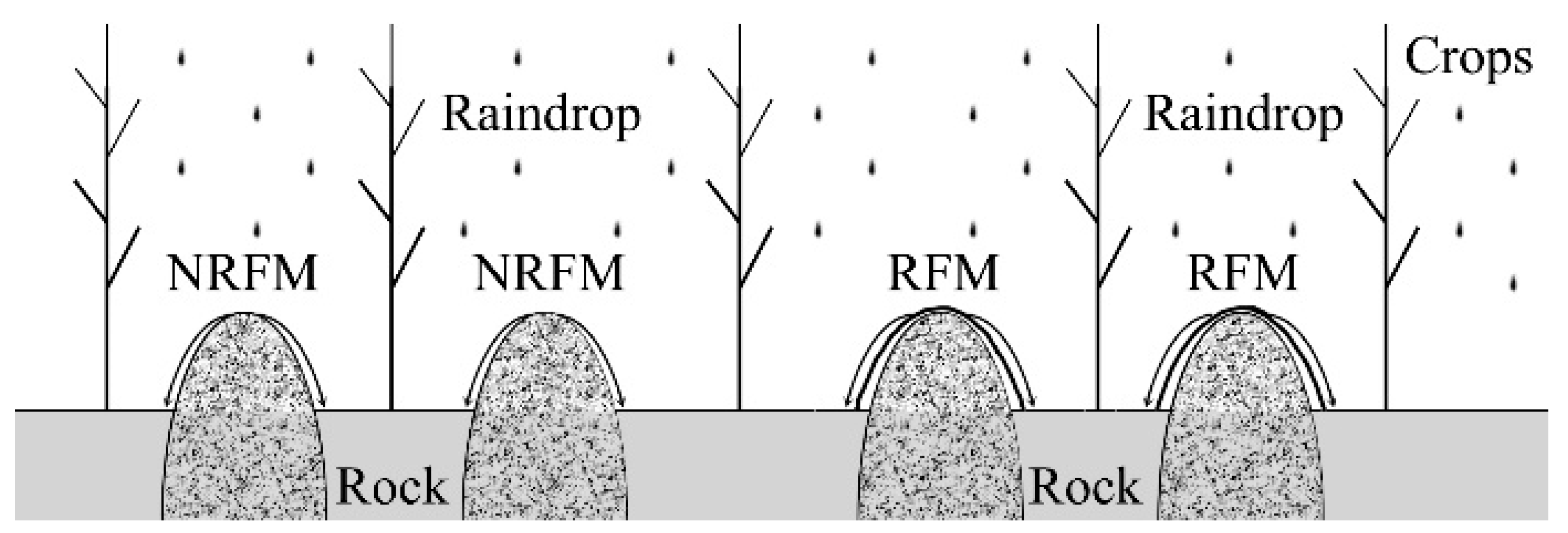
Polyethylene film (colorless and transparent, 1 mm thick) was used to completely cover a rock on the ground, and a trench was dug around the rock to fix the edge of the film. The trench was at least 20 cm deep and a distance of more than 20 cm from the rock (Figure 2). In the process of covering the rocks with polyethylene film, attention was paid to avoid the film being cut by the rocks.
2.3. Dye Tracer Test
Brilliant Blue FCF (4 g/L) was used as dye tracer to simulate soil water infiltration. The dye tracer solution is non-toxic, highly soluble, and not easily adsorbed by soil. The basic process was divided into the following steps: (1) before applying the dye, carefully remove weeds and litter from the ground in order to ensure the dyeing effect, while taking care to avoid damaging the soil structure. (2) Apply 2 L of tracer solution to the rocks by way of spraying for about 10 min. (3) After the staining test, immediately record the soil surface staining with a high-definition camera. Additionally, after the tracer solution has permeated for 24 h, excavate a soil profile vertically along the stained area, and photograph each stained soil profile with the camera. (4) Correte and clip the soil profile image, and measured the staining pattern information (dyeing depth, dyeing width, preferred flow index, etc.)
The preferential flow index (%) was calculated as follows [25]:
where the uniform infiltration depth is calculated as the depth at which the dye coverage decreases below 80%, indicating the depth to which the matrix flow is prevalent.
2.4. Soil Water Content Measurement
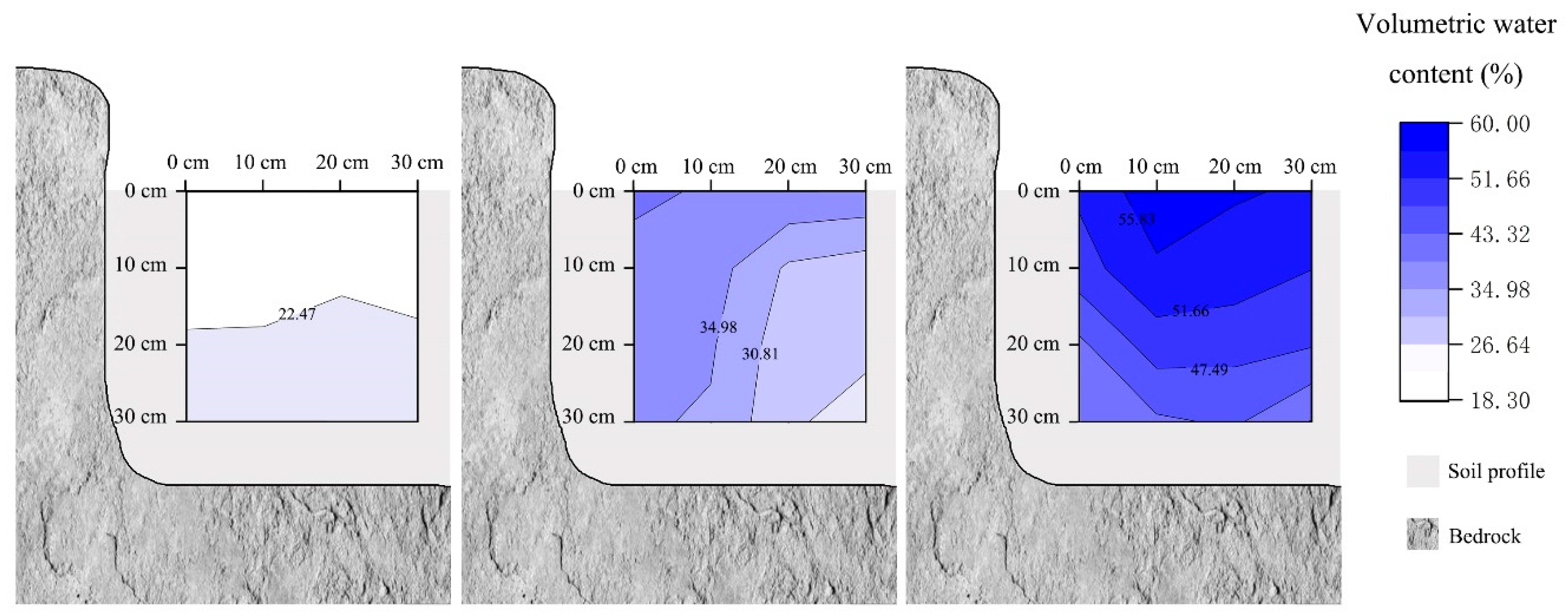
After the dye tracer test, a soil water meter (ML2-UM-3.0, Delta-T Devices Ltd., Cambridge, UK) was used to measure the volumetric water content within a measurement grid of 10 cm × 10 cm in the soil profile (width 30 cm, height 30 cm) (Figure 3). Additionally, a vertical reference profile at a distance of 20 cm away from sampling site was prepared for the measurement of antecedent soil water content, which was not affected by the dye tracer application in the vicinity of the experimental plot.
2.5. Data Analysis
Microsoft Excel 2010 was used for recording data and IBM SPSS Statistics 22 and Matlab 2016b were used for the statistical analyses. One-way analysis of variance at the level of 0.05 was used to determine the statistically significance. OriginPro 2023 and Photoshop CS6 software were used for drawing.
3. Results
Table 2 shows the staining characteristics and the changes in soil water content after the staining tracer test under the two different treatments.
3.1. Soil Water Flow Paths
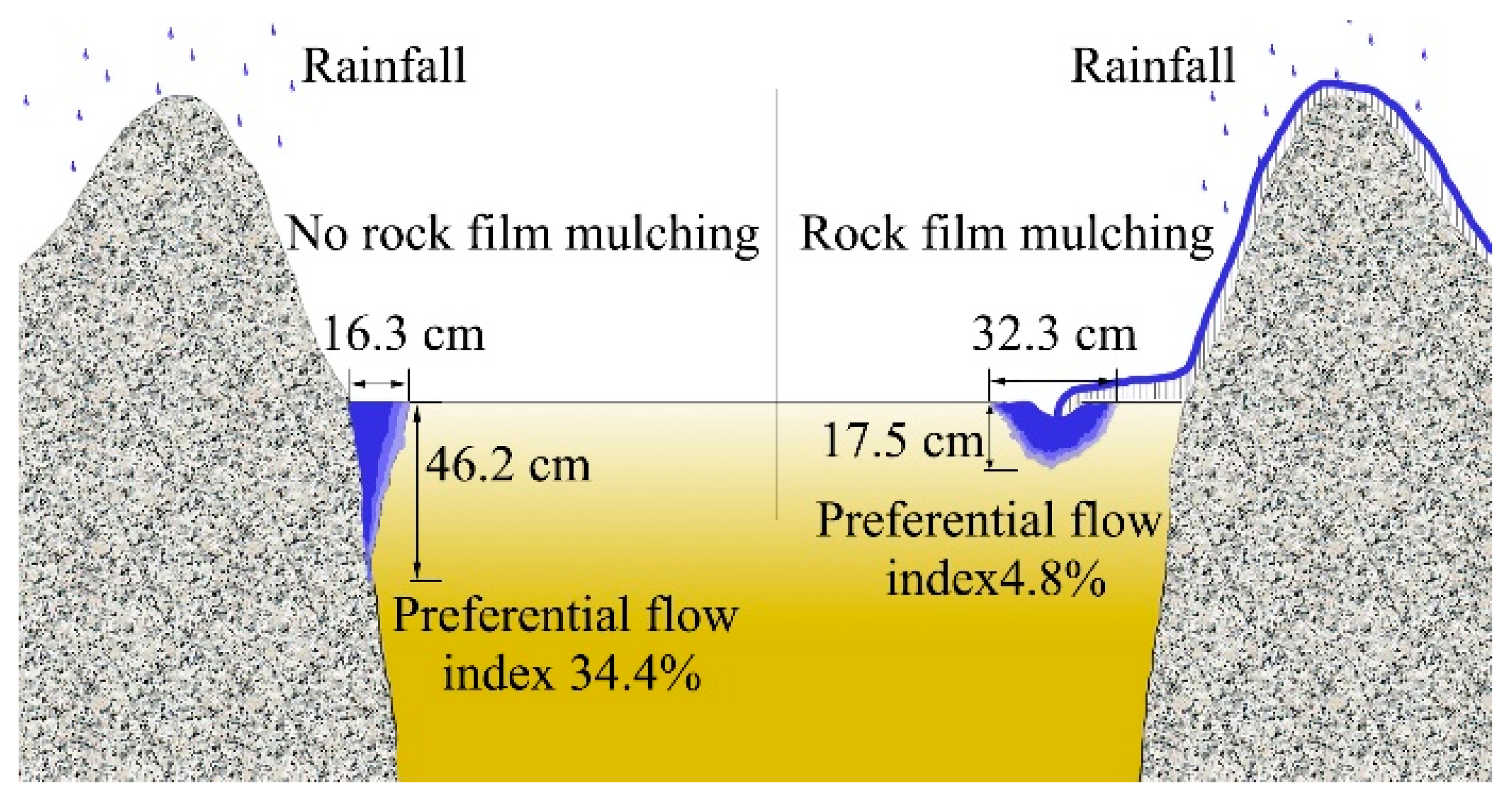
In the study, Brilliant Blue FCF had a good effect on soil staining, and the redistribution of the water intercepted from a rock could be clearly seen through the soil profile. The results of analysis of variance showed that there were significant differences in staining results between the two groups of experiments (p < 0.05). In the NRFM, the preferential flow was very obvious in the soil, and vertical percolation dominated. Water penetrated down along the rock–soil interface and reached the underground clay layer (Figure 4). Under this treatment, the average depth of water flow paths was 46.2 cm, the maximum depth was 53.5 cm, the average width of water flow paths was 16.6 cm, the maximum width was 22.4 cm, and the average preferred flow index was 34.4%.
In contrast, the preferential flow in soil was not so obvious in the RFM. The water intercepted by a rock did not penetrate down along the rock–soil interface, but was transferred to the surrounding soil surface by the film cover on the above-ground rock. Under this treatment, the redistribution of water in the soil was confined to a range of 0~20 cm depth into the soil. The maximum depth of water flow paths was 22.4 cm, and the average depth was 17.6 cm, which was 61.9% lower than that under the treatment of no rock film. The maximum width of water flow paths was 41.3 cm, and the average width was 32.3 cm, which was 94.6% higher than that under the non-rock film treatment. The average preferred flow index was 4.8%, which was 86.0% lower than that of the NRFM.
3.2. Change in Soil Water Content
Before the dyeing tracer test, the antecedent water content of the soil in the two test groups was 16.9~24.2% (Table 1). After the staining tracer test, the soil water content of the two test groups was increased to different degrees (Figure 5). In the NRFM, the average water content of the soil profile was 31.4%, an increase of 36.0%. However, in the RFM, the average water content of the soil profile was 53.1%, which was significantly increased by 60.6% compared with the antecedent soil water content before dyeing. For the water content distribution of the soil profile, it has a similar trend as that of the infiltration pattern of dye tracer solution. The water tended to be distributed near the rock side in the NRFM but uniformly distributed in the RFM.
3.3. Change in Dye Coverage
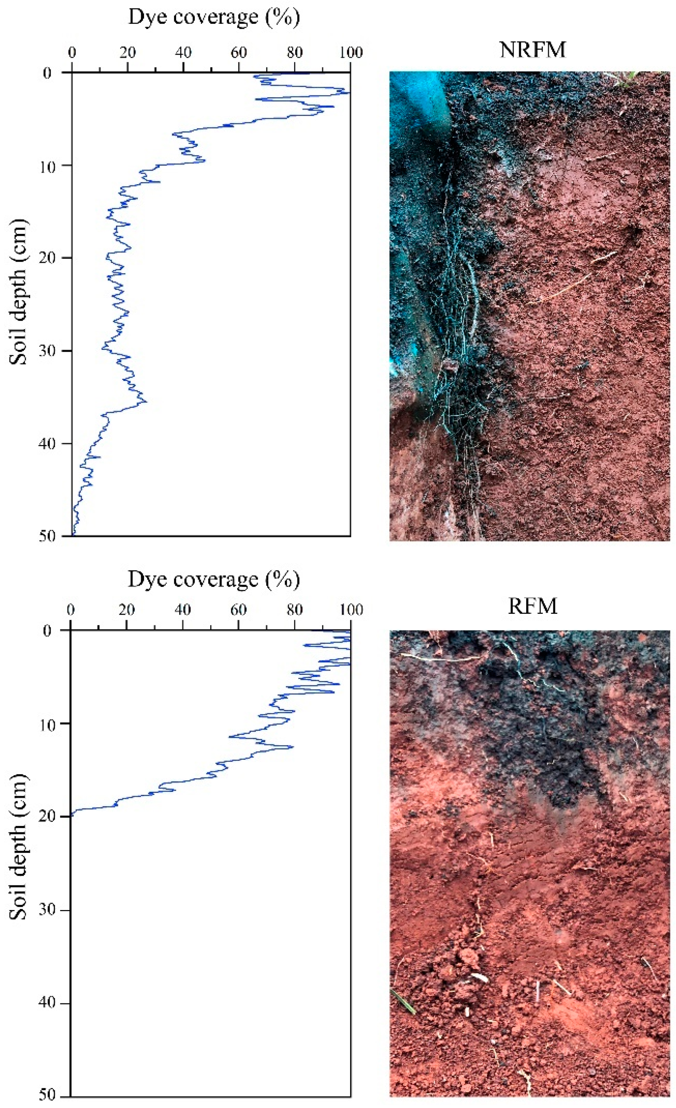
The stained soil profiles (30 cm width × 50 depth) and the change in dye coverage with soil depth in the profiles are shown in Figure 6. The depth of the uniform front of the RFM was deeper than that of the NRFM. The dye coverage of the RFM was greater than that of the NRFM. Comparing the change in dye coverage with soil depth between the two treatments, a visible difference in soil water flow was found, and the dye coverage greatly varied with soil depth in the NRFM but slightly varied in the RFM, which means the uniform infiltration of the water appeared at a shallower depth when the rocks were not covered with film. On the other hand, it tended to be more uniformly distributed and matrix flow dominated when the rocks were covered with film.
4. Discussion
4.1. Change in Soil Water Flow Paths
The dye tracer test clearly visualized some differences in soil water movement patterns in different treatments. The differences could potentially be attributed to the variability in water flow paths induced by the rock film mulching. In karst areas where surface rocks are not widely distributed, the soil clay content is large and the soil layer permeability is poor, so the vertical infiltration process of water flow will be affected to a certain extent. However, in rocky areas, rocks can direct vertical infiltration processes (as shown in Figure 6 of the dye tracer test), allowing soil water to penetrate through narrow bands at the rock–soil interface. Preferential flow correspondingly become one of the main ways of soil water loss in karst areas [9,26,27,28]. Most of the water moves quickly to deeper underground spaces, leaving little to remain in the soil matrix surrounding the rock. For karst rocky desertification areas, the preferential flow mainly occurs at the rock–soil interface and is affected by the characteristics of the underlying surface bedrock and the structure of soil and rock [29,30,31]. Especially in severe rocky desertification areas, the exposed bedrock and shallow soil lead to the very serious water and soil leakage phenomenon. It is of great significance to realize effective blocking of preferential flow at the rock–soil interface by rock film mulching to improve the utilization of water resources in rocky desertification areas and increase the possibility of natural precipitation absorption by plants.
This study shows that rock film mulching can effectively block the preferential flow at the rock–soil interface in karst areas and has an important effect on the distribution pattern of soil water around rocks. The quantitative indices (e.g., dye depth, dye width, and preferential flow index) clearly showed the development degree of preferential flow in the vertical direction (Table 2). Previous studies demonstrated that rock fragments can increase preferential pathways [32,33]. We also found similar results. In the case of no mulching, water can go deeper underground along the rock–soil interface, and only a little water spreads horizontally towards the soil (Figure 4), which undoubtedly reduces the compensation effect of rain on soil and makes it difficult for plants to make full use of rain. It is precisely for this reason that the formation of drought in karst areas is accelerated. Compared with the antecedent soil water content, the soil water content in the stained area did not significantly increase without mulching. On the other hand, the experiment proved that the water leakage at the rock–soil interface can be prevented to a certain extent by the film mulching treatment of above-ground rocks (Figure 4). The film covering the rock surface blocks the preferential flow channel of water infiltration when water moves down along the rock surface and thus preventing water leakage. Additionally, the water is subsequently transferred to the nearby soil patch and then permeated down from the soil surface evenly in the form of matrix flow (Figure 6). The experimental data showed that, compared with the antecedent soil water content before dye tracer test, the water content of the stained area under the rock film mulching treatment was mostly preserved in the soil matrix, and the soil water content was significantly increased (Table 2 and Figure 5). The comparison of the two treatments demonstrated that it was the bare rocks that showed a stronger preferential flow. Therefore, preventing and limiting the process of water loss at the rock–soil interface can be an effective means to solve water scarcity and improve water use efficiency in karst areas.
The rock film mulching changes the process of soil water infiltration, so that the overground rocks’ eco-hydrological utility can be preserved and maintained to the greatest extent. A large proportion of soil in rocky desertification areas is occupied by exposed rocks on the surface, which will collect a large amount of rainwater and deliver it to the surface soil in the process of rainfall. This phenomenon can be called the “funnel effect” or the “flowerpot effect” of overground rocks [34,35]. Using resin to randomly collect nutrient elements from overground rock runoff in Alpine mountains, it was found that overground rock can be used as a nitrogen hotspot to increase the spatial heterogeneity of soil N:P. As an important surface component in karst areas, the occurrence of overground rocks will inevitably change the distribution of rainfall and then affect the water content of the surrounding soil [35,36,37]. From the perspective of the soil structure of the dyed soil profile, rock film mulching can provide a large proportion of lateral flow, and improved preferential flow likely contributed to the spread and redistribution of soil water in the vertical and horizontal directions (Figure 6). Water lateral migration was considered as a potential water source of matrix flow [38,39,40]; therefore, rock film mulching diversifies water sources and supply. Plants that grow close to rocks tend to have higher plant heights and higher germination rates because rocks can transport extra water to the surrounding soil and organisms during rainfall, allowing them to obtain more water and thus promote growth [15]. Therefore, the above evidence points to the fact that rock film mulching can maximize the retention of rainwater intercepted by rocks, which can improve the utilization efficiency of natural precipitation of plants in karst areas, and undoubtedly help plants to survive in arid karst environments.
4.2. Application of Rock Film Mulching
Rock film mulching is an original technology and can be an effective technical means to alleviate karst drought in a karst geological background. Catchment agriculture generally uses artificial or natural catchment water surface to collect rainwater and store it; it also realizes the efficient use of natural precipitation through spatio-temporal regulation of water resources or uses technical means to direct rainwater to plant root zones to improve rhizosphere soil water status [22,41]. We believe that rock film mulching also has such advantages, which can significantly ply the ecological benefits of artificial enrichment of natural precipitation in situ. Through film mulching treatment of overground rocks, rainwater trapped on the rock surface can be transferred to the surrounding soil and become an extra supply of water for plants. At the same time, because the plastic film is impervious to water, any rainfall falling on the rock can be introduced into the surrounding soil along the plastic film. These deductions are supported by some previous studies [42,43,44,45,46]. Therefore, the regulation effect of rock films on rainfall distribution can be applied to any rainfall intensity. From this point of view, this measure can undoubtedly effectively improve the utilization rate of light rain by crops. In addition, mulching can reduce the evaporation and loss of soil surface water and give full play to the synergistic effect of the ecological factors of water and fertilizer [47,48,49]. In conclusion, rock film mulching blocks the vertical infiltration of soil water and increases the lateral migration of soil water so that crops can make full use of the rainwater distributed in the soil, emphasizing the spatial adaptability of water resources and the initiative of water utilization, and can become an effective way to restore the ecology and promote agricultural development in karst areas. Rock film mulching has the characteristics of low cost, strong operability, and wide application range, so it should be taken seriously and promoted in the future. At the same time, in order to avoid the possible pollution and harm of residual mulching film to soil and crops, it is suggested to popularize the application of fully biodegradable mulching film, and scientifically use and recycle mulching film to form a virtuous cycle and promote the green and high-quality development of southwest mountain agriculture.
5. Conclusions
Considering the water loss occurring at the interface between rock and soil, in this study, we evaluated the influence of rock film mulching (RFM) on the preferential flow process at rock–soil interfaces in a karst area using the dye tracer test. Additionally, water content monitoring was conducted to quantify the spatial distribution characteristics of soil water in the soil profile. It was found that RFM can effectively block the preferential flow path at the rock–soil interface and thus reduce the soil water leakage. The rainwater trapped by rocks was transferred to the surrounding soil surface along the film on the rocks and evenly permeated into the soil matrix, resulting in a significant increase in soil water content. In conclusion, RFM has an important blocking effect on preferential flow and water loss at the rock–soil interface, and the accumulation and diversion of rainfall by RFM can be an effective means to prevent and control water loss and improve the utilization of water resources for karst plants. Our findings also have important implications for the understanding of ecohydrological processes and water supply mechanisms in rocky karst areas.
Author Contributions
Conceptualization, Z.Z.; Methodology, Z.Z.; Software, Z.Z. and Q.W.; Validation, Z.Z.; Investigation, Z.Z. and Q.W.; Resources, Z.Z.; Data Curation, Z.Z. and Q.W.; Writing—Original Draft Preparation, Z.Z.; Writing—Review and Editing, Z.Z.; Project Administration, Z.Z.; Funding Acquisition, Z.Z. All authors have read and agreed to the published version of the manuscript.
Funding
This work was supported by Guizhou Province Colleges and Universities Young Science and Technology Talents Growth Projects (No. QJHKY [2022]296) and Guizhou Provincial Basic Research Program (Natural Science) (No. QKHJC-ZK[2023]YB281).
Data Availability Statement
Not applicable.
Acknowledgments
All the authors especially appreciate the experimental equipment provided by the Guizhou Provincial Key Laboratory of Geographic State Monitoring of Watershed, School of Geography and Resources, Guizhou Education University.
Conflicts of Interest
The authors declare no conflict of interest.
References
- Drew, D.P. Accelerated soil erosion in a karst area: The Burren, western Ireland. J. Hydrol. 1983, 61, 113–124. [Google Scholar] [CrossRef]
- Wang, S.J.; Li, R.L.; Sun, C.X.; Zhang, D.F.; Li, F.Q.; Zhou, D.Q.; Xiong, K.N.; Zhou, Z.F. How types of carbonate rock assemblages constrain the distribution of karst rocky desertified land in Guizhou Province, PR China: Phenomena and mechanisms. Land Degrad. Dev. 2004, 15, 123–131. [Google Scholar] [CrossRef]
- Bakalowicz, M. Karst groundwater: A challenge for new resources. Hydrogeol. J. 2005, 13, 148–160. [Google Scholar] [CrossRef]
- Calvo-Cases, A.; Boix-Fayos, C.; Imeson, A. Runoff generation, sediment movement and soil water behaviour on calcareous (limestone) slopes of some Mediterranean environments in SE Spain. Geomorphology 2003, 50, 269–291. [Google Scholar] [CrossRef]
- Herman, E.K.; Toran, L.; White, W.B. Clastic sediment transport and storage in fluviokarst aquifers: An essential component of karst hydrogeology. Carbonates Evaporites 2012, 27, 211–241. [Google Scholar] [CrossRef]
- Collon, P.; Bernasconi, D.; Vuilleumier, C.; Renard, P. Statistical metrics for the characterization of karst network geometry and topology. Geomorphology 2017, 283, 122–142. [Google Scholar] [CrossRef]
- Poesen, J.; Lavee, H. Rock fragments in top soils: Significance and processes. Catena 1994, 23, 1–28. [Google Scholar] [CrossRef]
- Williams, P.W. The role of the epikarst in karst and cave hydrogeology: A review. Int. J. Speleol. 2008, 37, 1–10. [Google Scholar] [CrossRef]
- Jomaa, S.; Barry, D.A.; Heng, B.C.P.; Brovelli, A.; Sander, G.C.; Parlange, J.Y. Influence of rock fragment coverage on soil erosion and hydrological response: Laboratory flume experiments and modeling. Water Resour. Res. 2012, 48, 213–223. [Google Scholar] [CrossRef]
- Luo, L.; Wu, Y.Y.; Li, H.T.; Xing, D.K.; Zhou, Y.; Xia, A.T. Drought Induced Dynamic Traits of Soil Water and Inorganic Carbon in Different Karst Habitats. Water 2022, 14, 3837. [Google Scholar] [CrossRef]
- Tu, N.; Dai, Q.; Yan, Y.; Peng, X.; Meng, W.; Cen, L. Effects of moss overlay on soil patch infiltration and runoff in karst rocky desertification slope land. Water 2022, 14, 3429. [Google Scholar] [CrossRef]
- Wang, Y.; Dai, Q.; Ding, P.; Li, K.; Yi, X.; He, J.; Peng, X.; Yan, Y.; Zhao, M.; Yang, Y. Rapid response of runoff carrying nitrogen loss to extreme rainfall in gentle slope farmland in the karst area of SW China. Water 2022, 14, 3341. [Google Scholar] [CrossRef]
- Rieke-Zapp, D.; Poesen, J.; Nearing, M.A. Effects of rock fragments incorporated in the soil matrix on concentrated flow hydraulics and erosion. Earth Surf. Process. Landf. 2010, 32, 1063–1076. [Google Scholar] [CrossRef]
- Zhao, Z.M.; Shen, Y.X.; Shan, Z.J.; Yu, Y.; Zhao, G.J. Infiltration patterns and ecological function of outcrop runoff in epikarst areas of southern China. Vadose Zone J. 2018, 17, 1–10. [Google Scholar] [CrossRef]
- Zhao, Z.M.; Shen, Y.X.; Jiang, R.H.; Wang, Q.H. Rock outcrops change infiltrability and water flow behavior in a karst soil. Vadose Zone J. 2020, 19, e20002. [Google Scholar] [CrossRef]
- Sohrt, J.; Ries, F.; Sauter, M.; Lange, J. Significance of preferential flow at the rock soil interface in a semi-arid karst environment. Catena 2014, 123, 1–10. [Google Scholar] [CrossRef]
- Gao, R.X.; Dai, Q.H.; Gan, Y.X.; Yan, Y.J.; Peng, X.D. The mechanisms of nutrient output through water flow from sloping farmland with slight rocky desertification in a karst region. Environ. Res. Lett. 2020, 15, 094085. [Google Scholar] [CrossRef]
- Fu, T.G.; Chen, H.S.; Zhang, W.; Nie, Y.P.; Gao, P.; Wang, K.L. Spatial variability of surface soil saturated hydraulic conductivity in a small karst catchment of southwest China. Environ. Earth Sci. 2015, 74, 2381–2391. [Google Scholar] [CrossRef]
- Morin, J.; Keren, R.; Benjamini, Y.; Ben-Hur, M.; Shainberg, I. Water infiltration as affected by soil crust and moisture profile. Soil Sci. 1989, 148, 53–59. [Google Scholar] [CrossRef]
- Laine-Kaulio, H.; Backnäs, S.; Koivusalo, H.; Laurén, A. Dye tracer visualization of flow patterns and pathways in glacial sandy till at a boreal forest hillslope. Geoderma 2015, 259, 23–34. [Google Scholar] [CrossRef]
- Alakukku, L.; Nuutinen, V.; Ketoja, E.; Koivusalo, H.; Paasonen-Kivekäs, M. Soil macroporosity in relation to subsurface drain location on a sloping clay field in humid climatic conditions. Soil Tillage Res. 2010, 106, 275–284. [Google Scholar] [CrossRef]
- Jiang, X.J.; Liu, W.J.; Wang, E.H.; Zhou, T.Z.; Xin, P. Residual plastic mulch fragments effects on soil physical properties and water flow behavior in the Minqin Oasis, northwestern China. Soil Tillage Res. 2017, 166, 100–107. [Google Scholar] [CrossRef]
- Kodešová, R.; Němeček, K.; Kodeš, V.; Žigová, A. Using dye tracer for visualization of preferential flow at macro-and microscales. Vadose Zone J. 2012, 11, 12–22. [Google Scholar] [CrossRef]
- Jiang, X.J.; Chen, C.F.; Zhu, X.A.; Zakari, S.; Singh, A.K.; Zhang, W.J.; Zeng, H.H.; Yuan, Z.Q.; He, C.G.; Yu, S.H.; et al. Use of dye infiltration experiments and hydrus-3d to interpret preferential flow in soil in a rubber-based agroforestry systems in xishuangbanna, China. Catena 2019, 178, 120–131. [Google Scholar] [CrossRef]
- Van Schaik, N. Spatial variability of infiltration patterns related to site characteristics in a semi-arid watershed. Catena 2009, 78, 36–47. [Google Scholar] [CrossRef]
- Wilcox, B.P.; Taucer, P.I.; Munster, C.L.; Owens, M.K.; Mohanty, B.P.; Sorenson, J.R.; Bazan, R. Subsurface storm flow is important in semiarid karst shrublands. Geophys. Res. Lett. 2008, 35, 1–6. [Google Scholar] [CrossRef]
- Jarvis, N.; Koestel, J.; Larsbo, M. Understanding preferential flow in the vadose zone: Recent advances and future prospects. Vadose Zone J. 2016, 15, 1–11. [Google Scholar] [CrossRef]
- Dai, Q.H.; Peng, X.D.; Yang, Z.; Zhao, L.S. Runoff and erosion processes on bare slopes in the karst rocky desertification area. Catena 2017, 152, 218–226. [Google Scholar] [CrossRef]
- Lange, J.; Greenbaum, N.; Husary, S.; Ghanem, M.; Leibundgut, C.; Schick, A.P. Runoff generation from successive simulated rainfalls on a rocky, semi-arid Mediterranean hillslope. Hydrol. Process. 2003, 17, 279–296. [Google Scholar] [CrossRef]
- Liu, T.T.; Peng, X.D.; Dai, Q.H.; Xu, S.B. Role of the preferential flow at rock–soil interface in the water leaking process in near–surface fissures filled with soils in the karst rock desertification area. Appl. Water Sci. 2022, 12, 208. [Google Scholar] [CrossRef]
- Ries, F.; Lange, J.; Schmidt, S.; Puhlmann, H.; Sauter, M. Recharge estimation and soil moisture dynamics in a Mediterranean, semi-arid karst region. Hydrol. Earth Syst. Sci. 2015, 19, 1439–1456. [Google Scholar] [CrossRef]
- Zhang, Y.; Zhang, M.; Niu, J.; Li, H.; Xiao, R.; Zheng, H.; Bech, J. Rock fragments and soil hydrological processes: Significance and progress. Catena 2016, 147, 153–166. [Google Scholar] [CrossRef]
- Qi, W.; Zhang, Z.Y.; Wang, C.; Chen, Y.; Zhang, Z.M. Crack closure and flow regimes in cracked clay loam subjected to different irrigation methods. Geoderma 2020, 358, 113978. [Google Scholar] [CrossRef]
- Göransson, H.; Edwards, P.J.; Perreijn, K.; Smittenberg, R.H.; Olde Venterink, H. Rocks create nitrogen hotspots and N:P heterogeneity by funnelling rain. Biogeochemistry 2014, 121, 329–338. [Google Scholar] [CrossRef]
- Shen, Y.X.; Zhao, Z.M.; Bi, S.C.; Zhao, G.J.; Liu, J. Rock outcrop and its ecological function in terrestrial ecosystem. Adv. Earth Sci. 2018, 33, 343–349. (In Chinese) [Google Scholar]
- Wang, D.J.; Shen, Y.X.; Huang, J.; Li, Y.H. Rock outcrops redistribute water to nearby soil patches in karst landscapes. Environ. Sci. Pollut. Res. 2016, 23, 8610–8616. [Google Scholar] [CrossRef] [PubMed]
- Shen, Y.X.; Wang, D.J.; Chen, Q.Q.; Tang, Y.Y.; Chen, F.J. Large heterogeneity of water and nutrient supply derived from runoff of nearby rock outcrops in karst ecosystems in SW China. Catena 2019, 172, 125–131. [Google Scholar] [CrossRef]
- Allaire, S.E.; Roulier, S.; Cessna, A.J. Quantifying preferential flow in soils: A review of different techniques. J. Hydrol. 2009, 378, 179–204. [Google Scholar] [CrossRef]
- Zhu, X.A.; Chen, C.F.; Wu, J.E.; Yang, J.B.; Zhang, W.J.; Zou, X.; Liu, W.J.; Jiang, X.J. Can intercrops improve soil water infiltrability and preferential flow in rubberbased agroforestry system? Soil Tillage Res. 2019, 191, 327–339. [Google Scholar] [CrossRef]
- Jačka, L.; Walmsley, A.; Kovář, M.; Frouz, J. Effects of different tree species on infiltration and preferential flow in soils developing at a clayey spoil heap. Geoderma 2021, 403, 115372. [Google Scholar] [CrossRef]
- Ghosh, P.K.; Dayal, D.; Bandyopadhyay, K.K.; Mohanty, M. Evaluation of straw and polythene mulch for enhancing productivity of irrigated summer groundnut. Field Crop. Res. 2006, 99, 76–86. [Google Scholar] [CrossRef]
- Witty, J.H.; Graham, R.C.; Hubbert, K.R.; Doolittle, J.A.; Wald, J.A. Contributions of water supply from the weathered bedrock zone to forest soil quality. Geoderma 2003, 114, 389–400. [Google Scholar] [CrossRef]
- Cook, H.F.; Valdes, G.S.; Lee, H.C. Mulch effects on rainfall interception, soil physical characteristics and temperature under Zea mays L. Soil Tillage Res. 2006, 91, 227–235. [Google Scholar] [CrossRef]
- Liu, Q.; Chen, Y.; Liu, Y.; Wen, X.; Liao, Y. Coupling effects of plastic film mulching and urea types on water use efficiency and grain yield of maize in the Loess Plateau, China. Soil Tillage Res. 2016, 157, 1–10. [Google Scholar] [CrossRef]
- Prosdocimi, M.; Jordán, A.; Tarolli, P.; Keesstra, S.; Novara, A.; Cerdà, A. The immediate effectiveness of barley straw mulch in reducing soil erodibility and surface runoff generation in Mediterranean vineyards. Sci. Total Environ. 2016, 547, 323–330. [Google Scholar] [CrossRef] [PubMed]
- Wright, S.N.; Novakowski, K.S. Numerical Analysis of Midwinter Infiltration along the Soil-Rock Interface: A Pathway for Enhanced Bedrock Recharge. Adv. Water Resour. 2022, 166, 104261. [Google Scholar] [CrossRef]
- Zhao, H.; Xiong, Y.C.; Li, F.M.; Wang, R.Y.; Qiang, S.C.; Yao, T.F.; Mo, F. Plastic film mulch for half growing-season maximized WUE and yield of potato via moisture-temperature improvement in a semi-arid agroecosystem. Agric. Water Manag. 2012, 104, 68–78. [Google Scholar] [CrossRef]
- Zhao, H.; Wang, R.Y.; Ma, B.L.; Xiong, Y.C.; Qiang, S.C.; Wang, C.L.; Liu, C.A.; Li, F.M. Ridge-furrow with full plastic film mulching improves water use efficiency and tuber yields of potato in a semiarid rainfed ecosystem. Field Crop. Res. 2014, 161, 137–148. [Google Scholar] [CrossRef]
- Zhou, L.M.; Li, F.M.; Jin, S.L.; Song, Y. How two ridges and the furrow mulched with plastic film affect soil water, soil temperature and yield of maize on the semiarid Loess Plateau of China. Field Crop. Res. 2009, 113, 41–47. [Google Scholar] [CrossRef]
Figure 1.
Rock film mulching on a karst rocky desertification plot. (a) No rock film mulching and (b) rock film mulching.
Figure 1.
Rock film mulching on a karst rocky desertification plot. (a) No rock film mulching and (b) rock film mulching.

Figure 2.
Diagram showing rock film mulching.

Figure 3.
Schematic diagram of the dye tracer test and measurement of soil water content.

Figure 4.
Effect of rock film mulching on the staining characteristics of soil profile.

Figure 5.
The water content distribution of soil profile. Antecedent soil water content (left), soil water content in the no rock film mulching (middle) and soil water content in the rock film mulching (right).
Figure 5.
The water content distribution of soil profile. Antecedent soil water content (left), soil water content in the no rock film mulching (middle) and soil water content in the rock film mulching (right).

Figure 6.
Change in dye coverage with soil depth in the dyeing profiles. NRFM (no rock film mulching), RFM (rock film mulching), soil profile (depth 50 cm × width 30 cm).
Figure 6.
Change in dye coverage with soil depth in the dyeing profiles. NRFM (no rock film mulching), RFM (rock film mulching), soil profile (depth 50 cm × width 30 cm).


Table 1.
Geographical characteristics of the sample site.
| Number | RFM | NRFM | Soil Particle Contents (%) | Vegetation Composition | ||||||
|---|---|---|---|---|---|---|---|---|---|---|
| Perimeter (m) | Height (cm) | Soil Water Content (%vol.) | Perimeter (m) | Height (cm) | Soil Water Content (%vol.) | Sand | Silt | Clay | ||
| 1 | 2.3 | 83.0 | 18.6 | 2.5 | 77.0 | 22.3 | Humus horizon (0–10 cm) | Zea may, Pyracantha fortuneana, Rubus biflorus, Ageratina adenophora, Bidens pilosa, Urtica fissa, Cirsium japonicum, Setaria viridis, Eleusine indica, Oplismenus compositus | ||
| 2 | 2.7 | 72.0 | 17.3 | 2.1 | 79.0 | 20.1 | 26.4 | 62.2 | 11.4 | |
| 3 | 3.2 | 64.0 | 22.5 | 2.9 | 83.0 | 24.2 | Eluvial horizon (10–30 cm) | |||
| 4 | 3.5 | 82.0 | 24.1 | 3.9 | 65.0 | 20.7 | 12.6 | 54.3 | 33.1 | |
| 5 | 2.9 | 77.0 | 16.9 | 3.1 | 69.0 | 18.9 | Illuvial horizon (30–100 cm) | |||
| 6 | 2.6 | 73.0 | 21.2 | 2.3 | 88.0 | 19.1 | 8.9 | 32.3 | 58.8 | |
| Mean | 2.9 | 75.3 | 20.1 | 2.8 | 76.8 | 20.9 | ||||
Notes: RFM (rock film mulching), NRFM (no rock film mulching). The wet-sieving method American system for soil texture classification were applied to obtain the soil particle size distributions. There was no significant difference in the soil particle contents and vegetation composition between the groups of RFM and NRFM (p > 0.05).
Table 2.
Staining characteristics and change in soil water content in the dye tracer test.
| Number | Dye Depth (cm) | Dye Width (cm) | Preferential Flow Index (%) | Soil Water Content (%vol.) | ||||
|---|---|---|---|---|---|---|---|---|
| NRFM | RFM | NRFM | RFM | NRFM | RFM | NRFM | RFM | |
| 1 | 49.6 | 19.3 | 14.8 | 27.4 | 36.3 | 5.3 | 37.9 | 51.3 |
| 2 | 50.2 | 22.4 | 13.2 | 26.3 | 37.9 | 5.9 | 31.1 | 48.7 |
| 3 | 38.8 | 13.8 | 22.4 | 41.3 | 27.8 | 3.7 | 25.5 | 44.2 |
| 4 | 53.5 | 18.2 | 11.9 | 29.8 | 42.3 | 5.1 | 32.6 | 58.9 |
| 5 | 41.9 | 16.7 | 20.2 | 32.5 | 30.7 | 4.5 | 27.1 | 54.1 |
| 6 | 43.1 | 14.9 | 17.3 | 36.7 | 31.5 | 4.1 | 34.4 | 61.2 |
| Mean ± SD | 46.2 ± 5.7 a | 17.6 ± 3.1 b | 16.6 ± 4.1 b | 32.3 ± 5.8 a | 34.4 ± 5.4 a | 4.8 ± 0.8 b | 31.4 ± 4.6 b | 53.1 ± 6.4 a |
Notes: Different letters in the table indicate a significant difference of 0.05 between the two groups; NRFM (no rock film mulching), RFM (rock film mulching); SD (standard deviation).
Disclaimer/Publisher’s Note: The statements, opinions and data contained in all publications are solely those of the individual author(s) and contributor(s) and not of MDPI and/or the editor(s). MDPI and/or the editor(s) disclaim responsibility for any injury to people or property resulting from any ideas, methods, instructions or products referred to in the content. |
© 2023 by the authors. Licensee MDPI, Basel, Switzerland. This article is an open access article distributed under the terms and conditions of the Creative Commons Attribution (CC BY) license (https://creativecommons.org/licenses/by/4.0/).
Share and Cite
MDPI and ACS Style
Zhao, Z.; Wang, Q. Effect of Rock Film Mulching on Preferential Flow at Rock–Soil Interfaces in Rocky Karst Areas. Water 2023, 15, 1775. https://doi.org/10.3390/w15091775
AMA Style
Zhao Z, Wang Q. Effect of Rock Film Mulching on Preferential Flow at Rock–Soil Interfaces in Rocky Karst Areas. Water. 2023; 15(9):1775. https://doi.org/10.3390/w15091775
Chicago/Turabian StyleZhao, Zhimeng, and Qinghe Wang. 2023. "Effect of Rock Film Mulching on Preferential Flow at Rock–Soil Interfaces in Rocky Karst Areas" Water 15, no. 9: 1775. https://doi.org/10.3390/w15091775
Note that from the first issue of 2016, this journal uses article numbers instead of page numbers. See further details here.