
Balancing Physical Channel Stability and Aquatic Ecological Function through River Restoration

1
Department of Geography, Environment & Geomatics, University of Guelph, Guelph, ON N1G 2W1, Canada
2
GEO Morphix Ltd., Cambellville, ON L0P 1B0, Canada
*
Author to whom correspondence should be addressed.
†
Present affiliation: GeoProcess Research Associates, Dundas, ON L9H 6Y6, Canada.
Water 2023, 15(9), 1799; https://doi.org/10.3390/w15091799
Submission received: 13 April 2023
/
Revised: 29 April 2023
/
Accepted: 5 May 2023
/
Published: 8 May 2023
(This article belongs to the Special Issue Fluvial Geomorphology, River Management and Restoration)
Abstract
:Vortex rock weirs (VRW) are often used in natural channel design applications to maintain channel form and function, provide physical channel stability, and enhance aquatic habitats. A balanced approach is required to address (often) conflicting goals of VRWs, which include providing erosion protection and grade control while facilitating fish passage for target species. This research evaluated a sequence of modified VRWs in a small-scale watercourse in Southern Ontario, Canada. To determine passage suitability for the target fish species, the water level, water temperature, and channel geometries at 10 VRWs and 11 adjacent pools were monitored under different water level conditions. The structural dimensions and velocity at each VRW were compared to the burst swim speed of local small-bodied fish species to determine fish passage suitability and identify the best practices for VRW design and construction. The results concluded that VRWs provided suitable passage for small-bodied fish species through gap and over-weir flow pathways, particularly during low water level conditions. Further, appropriate design considerations based on the VRW gradient, VRW width, keystone size, and pool length contributed to 100% fish ‘passability’ under all water level conditions. The methodology is provided for predicting the velocity and small-bodied fish passage suitability through VRWs, informing the best practices for VRW design and construction while balancing the requirements for channel stability and fish passage, and contributing to fish population management strategies.
1. Introduction
The surrounding land use heavily influences river systems [1,2,3]. Specifically, pressures from urban development contribute to changes in water and sediment delivery. This effectively alters the flow mechanics and sediment dynamics of river systems. Additionally, in-stream structures (e.g., dams) cause habitat fragmentation and disrupt longitudinal connectivity for riverine species [4]. To maintain fluvial geomorphological connectivity and aquatic ecological function (i.e., fish passage) in ecosystems impacted by urban development, river restoration is required [5,6,7]. Vortex rock weirs (VRWs) are one of the most commonly constructed nature-like fishways [8,9,10] and provide physical channel stability, habitat enhancement, and the hydromechanics to allow upstream fish passage for local fish species. VRWs have conflicting goals in terms of function, where they are installed as a high flow feature to ensure channel stability but provide conditions for low flow processes such as fish passage [11,12,13,14].
VRWs vary in structure and geometry and are tailored to site-specific conditions depending on the channel morphology and hydrologic regime [15]. Where VRWs are used to facilitate fish passage, design considerations also include the behavioral and physiological characteristics (e.g., swim speeds) of target fish communities [9,16,17]. Many studies have evaluated fish passage effectiveness through conventional fishways or using flumes [11,13,18,19,20,21]; however, there have been fewer experiments that consider the irregularity of natural materials and the unique design of VRWs [22]. Further, given many conventional fishways are designed for large-bodied fish species in large-scale river systems, the number of studies that have focused on the suitability of VRWs for small-bodied fish passage through small-scale systems are limited [11]. Hydraulic criteria, including velocity and depth through the VRW, are the main factors in determining fish passage suitability [23].
The purpose of this research was to evaluate the suitability of modified VRWs for small-bodied fish passage through a section of Weslie Creek in Ontario, Canada (Figure 1). Data collection was completed under various water level conditions in 2018 to observe changes in the VRW hydraulic criteria. VRW geometry and flow characteristics were used to inform small-bodied fish passage suitability based on providing adequate velocities for target fish species through gap and over-weir flow pathways. The structural dimensions of the VRWs were assessed to understand how design and construction influence small-bodied fish ‘passability’ and opportunities for fish refuge. Critical design and construction components for facilitating small-bodied fish passage through modified VRWs, while also ensuring channel stability, were also determined to inform future river restorations.
2. Study Site
Research was conducted at Weslie Creek, one of four major tributaries of the East Holland River, located in Aurora, Ontario, Canada (Figure 1). A section of Weslie Creek was restored following road improvements and removal of a dam. VRWs were used to provide channel and bank stability and facilitate fish passage for local species. The average annual temperature is approximately 6 °C, and the average annual precipitation is approximately 815 mm [24]. The peak discharge events are associated with snowmelt and spring rainfall, which typically occur from March to April and April to May, respectively. Based on the Water Survey of Canada (Station 02EC009; approximately 9 km from the study site), the 2018 mean annual discharge for East Holland River was 1.77 m3/s. This is above average compared to the mean annual discharge for East Holland River over the previous 10 years, which was 1.57 m3/s. According to the Ontario Watershed Information Tool (OWIT), the mean annual flow for the 9.5 km2 drainage basin containing Weslie Creek is 0.09 m3/s, as this is a small system.
3. Methods
In spring 2018, 10 individual VRWs and 11 associated pool features were selected and surveyed for monitoring at Weslie Creek (Figure 1). Using a real-time kinematic global positioning system (RTK GPS), a topographical survey was completed for the reach, each pool cross-section, each VRW cross-section, and each VRW keystone. The reach profile and cross-section elevation data were collected by measuring the channel bed and water surface elevation points with the RTK GPS every 20 cm. The VRW keystone elevation data were collected by measuring the elevation with the RTK GPS on the surface of each keystone and around the exposed (i.e., protruding from the channel bed) circumference. The RTK GPS produced elevation data accurate to +/−0.02 m.
Physical habitat conditions, including water depth and temperature, were monitored continuously from June to October 2018 (the duration of the field program) using Onset HOBO pressure transducers. One sensor was installed in a stilling well at pool 7 and another on the adjacent bank to collect atmospheric pressure data, and the values were recorded hourly. The data were retrieved from each sensor every two weeks to ensure data quality and assess equipment function, particularly following large rainfall events. Modified Wolman [25] pebble counts were completed (measuring 20 pebbles at each pool feature), and monumented photographs were taken on a biweekly basis to determine the bed substrate composition and record changes at each pool throughout the duration of the field program.
Velocity measurements were collected throughout Weslie Creek under three water level conditions: low, intermediate, and high (Supplementary Materials Figure S1). These classifications were based on site-specific conditions. A low water level was representative of the system with no rainfall over a 72-h period. A high water level was representative of the system following a rainfall event (data collected within 24 h of the rainfall event). An intermediate water level was representative of the system more than 24 h following a rainfall event but not yet at the base flow. The purpose of capturing hydraulic data under three water level conditions was to inform how fish passage suitability differs depending on the inputs to the system.
Velocity measurements were collected using a three-dimensional acoustic Doppler velocimeter (ADV, SonTek FlowTracker2) (+/−0.01 m/s). At each pool, the ADV was positioned perpendicular to the flow at 60% depth. Velocity measurements were collected every 10 cm from the left bank to right bank [26,27]. At each VRW (10 structures in total), velocity measurements were collected at active gap and/or over-weir flow pathways. Additionally, the pathway geometries were measured to characterize the passage area (Figure 2). Under intermediate and high water level conditions, where the gap and/or over-weir flow pathways were larger in width, multiple velocity measurements were collected across the pathway, and an average ‘cross-section’ velocity was identified for the associated pathway.
To evaluate small-bodied fish passage suitability through the VRWs, the swimming characteristics of the local fish species were compared to the velocities through the VRW gap and over-weir flow pathways (Table 1). The target fish species (i.e., small-bodied fish species) were identified by reviewing the local watershed and sub-watershed reports. The swimming characteristics for each small-bodied fish species were identified by reviewing the relevant literature. This approach was nonintrusive and offered an adequate understanding of the hydrodynamic requirements for fish passage suitability.
4. Results
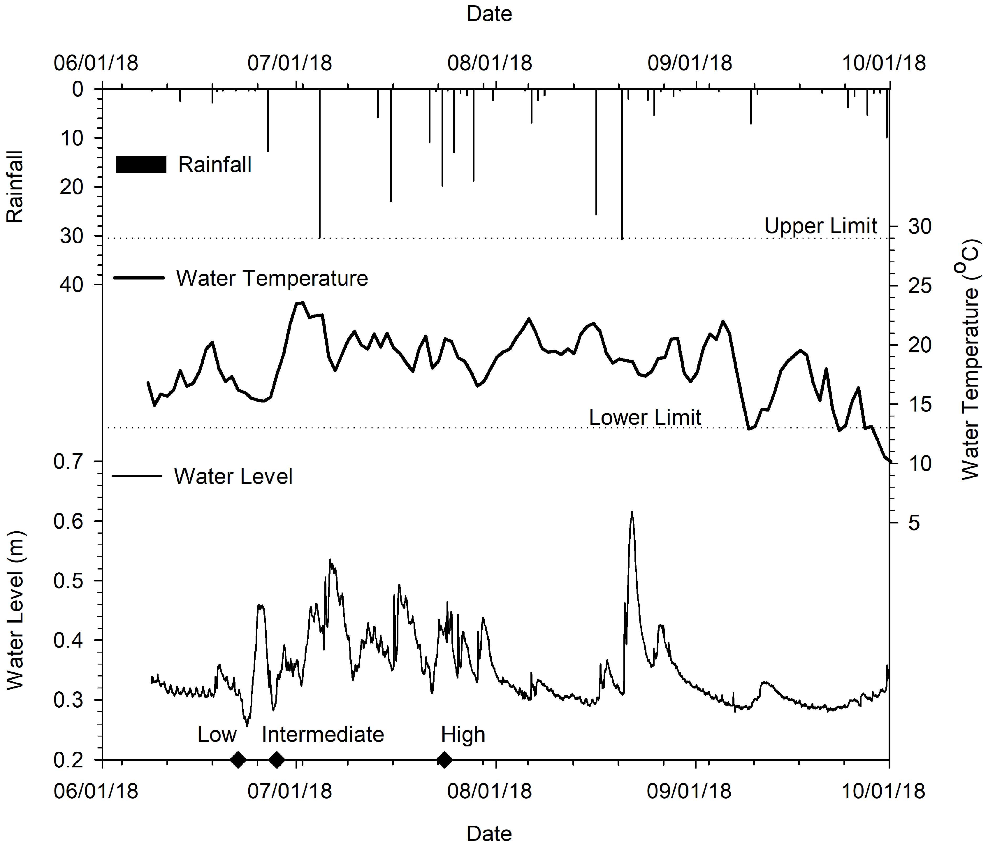
The water levels, as measured in pool 7, ranged from 0.27 m to 0.61 m during the assessment period (Figure 3). The minimum water level was recorded on 23 June 2018, and the maximum water level was recorded on 22 August 2018. Three general water level conditions (low, intermediate, and high) were identified over the assessment period. The average daily water temperature ranged from 10 °C to 23.5 °C (Figure 3). The minimum water temperature was recorded on October 1, 2018, and the maximum water temperature was recorded on July 1, 2018. During site visits, there were incidental observations of small-bodied fish species in the pools moving upstream through the VRWs (Supplementary Materials Figure S2). These species were identified through visual inspection as blacknose dace (Rhinichthys atralutus), creek chub (Semotilus atroma-culatus), and mottled sculpin (Cottus bairdi), which coincided with the species historically observed in Weslie Creek [24].
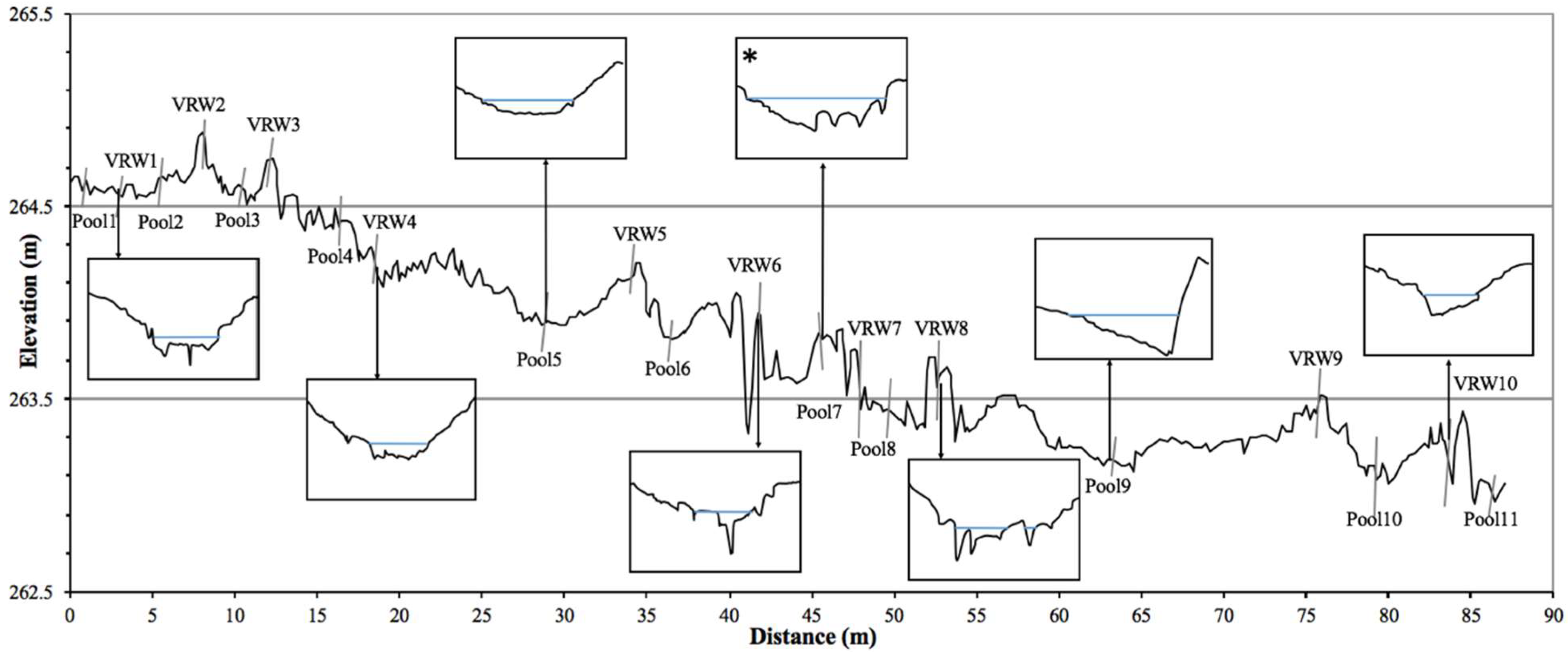
This Weslie Creek section had a slope of 0.02 (2%), and the low flow channel had a sinuosity of 1.32 (Figure 4). All cross-sections were identified as asymmetrical, with varying channel bank slopes and different keystone geometries (i.e., shape and size) (Figure 4). Further, VRW asymmetry alternated between cross-sections (Figure 4). Bed substrate distribution curves were developed for each pool to reflect the Wolman [25] pebble counts. The results of each pebble count were merged and organized by pool to identify changes in the bed substrate composition throughout the assessment period. Given the similarity in the bed substrate distribution curves for 22 June, 28 June, 13 July, 25 July, 14 August, and 7 September, it was determined that the bed substrate composition did not change during the assessment period [29].
Over 530 velocity measurements were collected to identify the range of velocities at each pool feature. Collectively, under all water level conditions (i.e., low, intermediate, and high), the cross-section velocity in the pool features ranged from −0.14 m/s to 0.83 m/s. Recirculation zones were located near the channel banks in 6/11, 7/11, and 10/11 pools under low, intermediate, and high water levels. Recirculation zones were recognized as locations where the velocity was measured as a negative value, indicating the flow was moving upstream at that point of the cross-section.
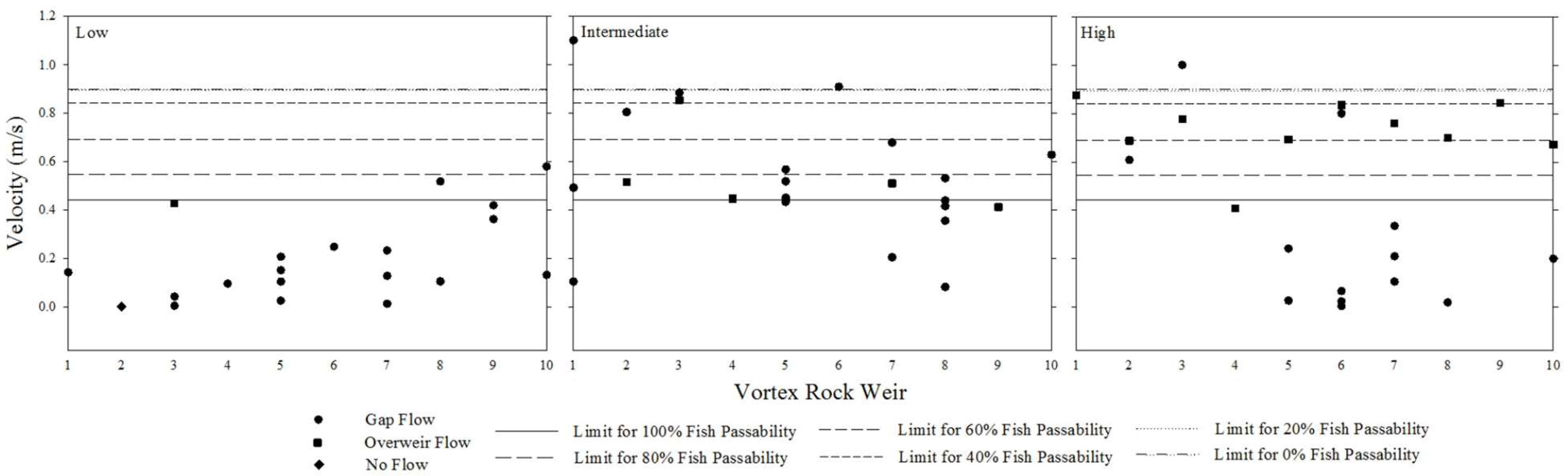
Over 70 velocity measurements were collected in active gap and over-weir flow pathways through VRWs under low, intermediate, and higher water level conditions. Velocities in the gap pathways ranged from −0.14 m/s to 1.10 m/s. Velocities in the over-weir flow pathways ranged from 0.10 m/s to 0.18 m/s. Depending on the water level, the ratio of gap to over-weir flow pathways and the total number of active flow pathways differed. Under low water level conditions, there were a greater number of gap flow pathways. As the water level increased, individual gap flow pathways merged to form one large gap, and/or over-weir flow pathways began to form. At the high water level, the number of gap flow pathways reduced, while the flow over the keystones (over-weir flow) became more common. The ratio of gap to over-weir flow pathways was 17:1, 18:5, and 11:10 under the low, intermediate, and higher water level conditions.
The local fish community consisted of small-bodied fish with known swim speeds that were considered in the VRW design. A comparison between velocities through pool features, velocities through VRWs (gap and over-weir flow pathways), and burst swim speeds (m/s) was completed to identify where a fish passage was or was not suitable under different water level conditions. Additionally, the preferred water temperature range for all local fish species was compared to the measured water temperature collected at pool 7 to further characterize the habitat suitability in pools. Finally, the vertical distance between weir crest and the downstream pool at each VRW was measured to determine if upstream movement was possible via fish leaping, given leap distances for the local fish species previously published in the literature.
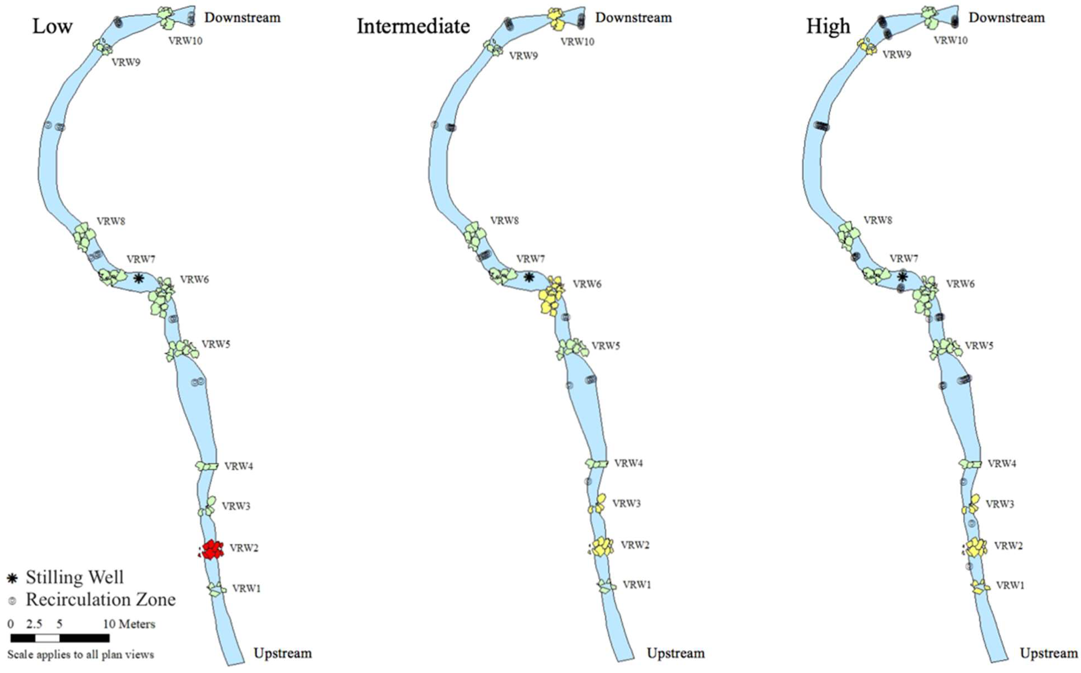
Based on fish passage suitability, the longitudinal connectivity throughout the reach was analyzed under low, intermediate, and high water level conditions (Figure 5). Under low water level conditions (June 22), 100% fish passage suitability (passable for all fish species) was achieved for all pool features and for 9/10 VRWs (Figure 5—Low). Under low water level conditions, there was no gap or over-weir flow throughout VRW2, which restricts fish passage (Figure 5—Low). Under intermediate water level conditions (June 28), 100% fish passage suitability was achieved for all pool features and for 6/10 VRWs (Figure 5—Intermediate). Under intermediate water level conditions, the gap and over-weir flows at VRW2, VRW3, VRW6, and VRW10 exceeded the burst swim speeds of one or more local small-bodied fish species. However, one to three pathways were available for faster swimming species (Figure 5—Intermediate). Under high water level conditions (July 25), 100% fish passage suitability was achieved for all pool features and for 6/10 VRWs (Figure 5—High). Under high water level conditions, the gap and over-weir flows at VRW1, VRW2, VRW3, and VRW9 exceeded the burst swim speeds of one or more local small-bodied fish species. However, one to two pathways were available for faster swimming species (Figure 5—High).
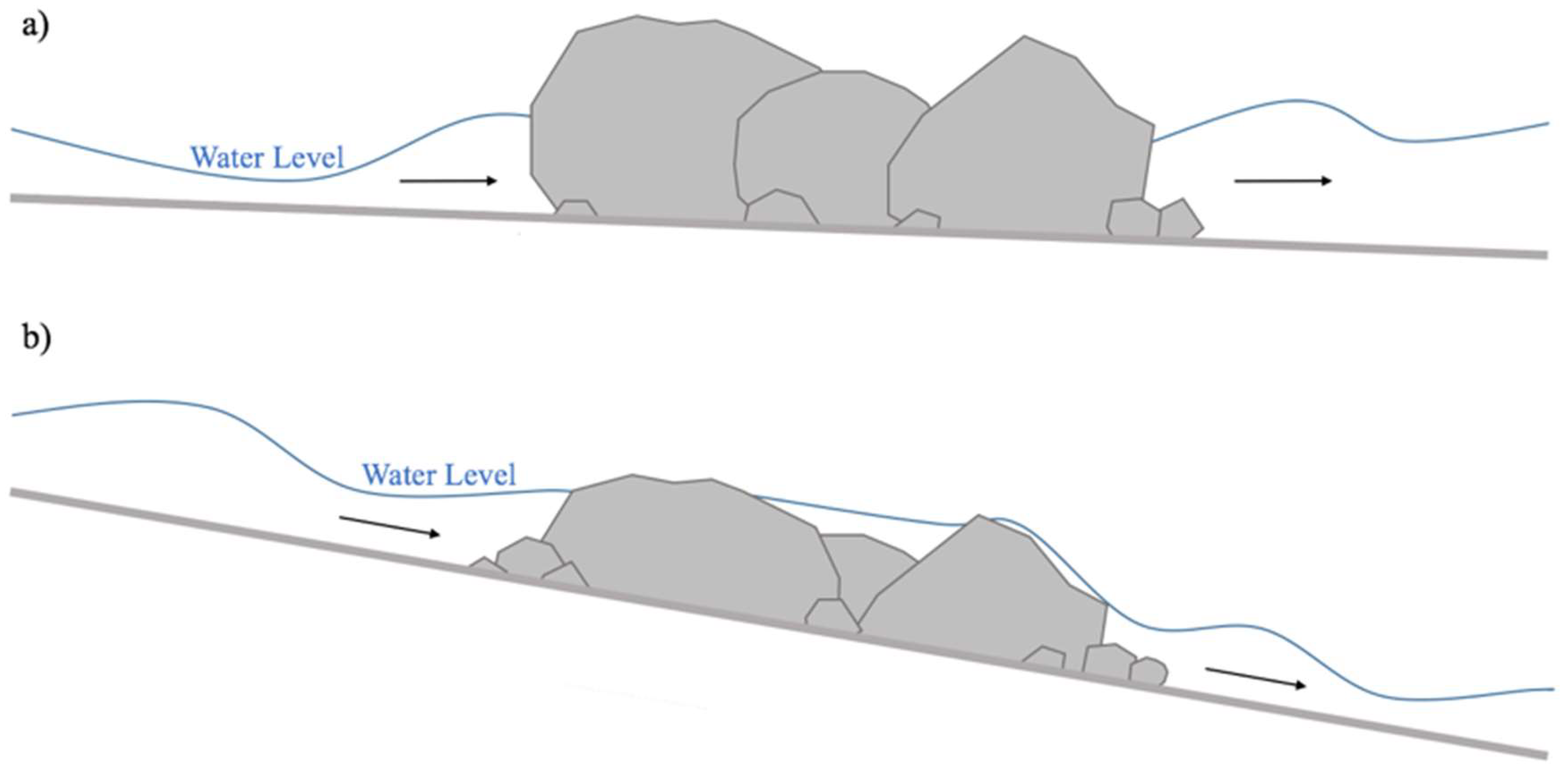
Depending on the water level and VRW design, different flow pathways were available for fish passage (Figure 6). At VRW2, under low water level conditions, the only possible flow pathways were through orifices. This was true for other low-gradient VRWs throughout the reach (Figure 7a). Further, at a high-gradient VRW (e.g., VRW7) (Figure 7b), the vertical distance between the upstream water level and weir crest was minimal, and therefore, connectivity was maintained between the upstream and downstream flows. In addition to the water level and velocities, the weir gradients were assessed with respect to fish passage suitability (Table 2).
Depending on the water level and weir gradient, VRW keystones are either exposed or ‘drowned’. Under low water level conditions, low-gradient VRW keystone surfaces are exposed, and water moves downstream through orifice flow pathways. Under intermediate water level conditions, low-gradient VRW keystones begin experiencing ‘drowned conditions’, where approximately 50% of the keystone surfaces are submerged, and water moves downstream through orifice and gap flow pathways. Under high water level conditions, low-gradient VRW keystones experience fully ‘drowned conditions’, where keystone surfaces are submerged, and water moves downstream through orifice, gap, and over-weir flow pathways. Particularly in locations where low water level conditions are most frequent (i.e., Weslie Creek), low-gradient VRWs may impede fish passage by limiting gap and over-weir flow pathways for upstream movement. High-gradient VRWs (Figure 7b) experience more frequent ‘drowned conditions’ than exposed conditions and, therefore, provide greater opportunities for small-bodied fish species to maneuver through gap and over-weir flow pathways.
When the velocities for upstream or downstream movement are not favorable, habitat conditions within pools serve as a refuge with respect to flow and temperature. The range of preferred water temperatures for local small-bodied fish species was identified and compared to the average daily water temperature measured in Weslie Creek. The average daily water temperature was consistently within the preferred range for local small-bodied fish species from 6 June to 24 September. The water level logger was placed in pool 7 (Figure 4), which was deeper than the other pool features within the reach; thus, the water temperature was likely cooler in this pool than in more shallow pools (i.e., Pool 5—Figure 4).
To assess the pool design in terms of both fish passage and refuge suitability, the length of each pool was identified and compared to the downstream fish passage suitability and the number of refuge opportunities available at the sampling cross-sections, respectively (Table 3). These results indicated that longer pools facilitate fish passage suitability, and 10/11 pools provided opportunities for fish habitat and/or refuge under all water level conditions.
Another easily identifiable VRW dimension related to fish passage is the ratio of VRW size to channel width. The width of a channel, and subsequently, the width of a constructed VRW, influences the number and size of keystones used in the design. A larger cross-section requires more keystones, footer stones, and river stones to construct the VRW between channel banks. The fish passage suitability under different water levels was examined as a function of the VRW width to determine if this design consideration could inform fish passage suitability (Table 4).
5. Discussion
5.1. Critical VRW Design Components for Suitable Fish Passage
Based on the results of this analysis, the critical VRW design components for suitable fish passage include:
- Gradient;
- Keystone characteristics;
- VRW geometry.
In nature-like fishways, asymmetrically positioned keystones with varying geometries are used to induce three-dimensional circulation (downstream, across the stream, and within the water column) [11]. The asymmetrical nature of the VRWs assessed introduces a secondary gradient and sinuosity throughout the cross-section and maintains geomorphic channel stability under different flow conditions (Figure 4). An asymmetrical VRW design offers suitable fish passage for small-bodied fish species by activating gap and over-weir flow pathways—either independently or simultaneously—depending on water level at Weslie Creek (Figure 5).
5.1.1. VRW Gradient
At Weslie Creek, the three VRWs that were suitable for fish passage under all water level conditions had the steepest VRW gradients throughout the reach (−0.086 to −0.144; Figure 5 and Table 2). The higher VRW gradient decreases the vertical distance between the upstream water level and weir crest and enhances the keystone embeddedness (Figure 7), which provides adequate gap and over-weir flow pathways for movement and ultimately maintains longitudinal connectivity throughout the restored system [30]. Although steep slopes are considered a flaw in conventional fishway designs [8,31], nature-like fishways provide a naturally gradual slope through the reach [32], and as such, higher secondary gradients at the VRWs are more acceptable. There is limited information about the VRW gradient as it relates to small-bodied fish passage in the literature [11]. Rather, comparable metrics (e.g., culvert and fish ramp angle) are commonly discussed in the context of fish passage [33,34]. In these studies, steeper culvert/ramp gradients are shown to increase the velocity and reduce fish passage for small-bodied fish species. Given that VRWs are implemented as nature-like structures within the channel bed and offer inherent flow dispersion, this relationship does not apply. The findings presented here indicate that VRW gradients influence fish passage suitability for small-bodied fish species. This finding is particularly useful, because the VRW gradient is easily identifiable and can be used as a metric to assess fish passage suitability rapidly without conducting extensive in-field data collection campaigns.
5.1.2. Keystone Characteristics
In this study, VRWs that provided 100% fish passability had consistent weir crest widths greater than 3.0 m (Table 4). Further, all VRWs that allowed 100% fish passability had a greater than average number of keystones and range of keystone sizes (Table 4). The 100% fish passage suitability was likely attributed to the number of flow pathways that were available with a greater number of keystones and range of keystone sizes filling the cross-section. The VRW throat width is a parameter used to inform failure rates for in-stream structures, with results suggesting that the larger the VRW throat width, the less there is a common failure [35]. However, studies evaluating the relationship between the VRW throat width (or crest width for modified VRW designs) and fish passage are not available. Given the indications from this study, the keystone characteristics and throat width are important to fish passage opportunities.
VRW keystones are hydraulically sized and selected to withstand high flow events throughout a reach [12]. Large keystones are used for channel stability, which reduces the number of keystones required to fill the cross-section and, further, reduces the potential pathways for fish passage. Based on the findings presented here (Figure 5 and Table 4), and to address the conflicting goals between geomorphic channel stability and fish passage in river restoration (e.g., Birnie-Gauvin et al. [11]), it is recommended that keystones be sized to enhance gap flow pathways for fish passage but not undermine channel stability, particularly during high flow events. This design consideration can be incorporated to ensure resilience and fish passability for the local fish community.
5.1.3. VRW Geometry
Embeddedness
The VRWs in Weslie Creek are asymmetrical (Figure 4), which provides a secondary gradient for fish passage to enhance the longitudinal connectivity depending on the water level. However, the VRW that restricts gap and over-weir flows under low water level conditions (VRW2) (Figure 5) has a low gradient and is less embedded near the weir crest than other VRWs (Table 2). As such, the keystones protrude further out from the channel bed, reducing the longitudinal connectivity (Figure 7). This limits the opportunities to activate gap or over-weir flow pathways. Rather, water moves as an orifice flow and enters the downstream pool through available gaps beneath the keystones. Keller et al. [16] described VRW designs that required ‘drowned conditions’ to facilitate fish passage. The Weslie Creek system shows findings consistent with the necessary conditions for suitable fish passage at VRW2, where opportunities for gap and over-weir flow pathways are only available under intermediate and high water levels (i.e., ‘drowned conditions’) (Figure 7).
Depending on site-specific water level characteristics, design considerations should be applied to construct VRWs with a suitable level of embeddedness, such that there are opportunities for ‘drowned conditions’ to enhance fish passage suitability. For example, Weslie Creek experiences low water level conditions for the majority of the year, and as such, VRWs should be constructed with a high degree of embeddedness for maintaining longitudinal connectivity (Figure 5). However, in systems characterized by high water level conditions, constructing VRWs that can withstand ‘drowned conditions’ is likely more important than embeddedness. If ‘drowned conditions’ are more common in these systems, longitudinal connectivity and fish passage suitability would increase throughout the reach. In terms of embeddedness, it is important that the material size used for constructing VRWs is large enough to maintain stability in higher-magnitude flows (e.g., Q10–20) [36] but small enough to remain embedded. These dimensions are based on site-specific characteristics, as well as requirements for the target fish community, to ensure passage is possible at critical times (i.e., spawning periods). Similar to the VRW gradient and keystone characteristics, assessing embeddedness under low water level conditions has the potential for use as a method to preliminarily and rapidly monitor fish passage suitability (in terms of drowned conditions) without conducting extensive in-field data collection.
Orifices
Orifices are challenging to survey post-construction and were assumed to have minimal impact with regards to facilitating fish passage in this study. In various river restoration projects, impermeable geotextile layers are installed at the stream bed and upstream of the weir crest to prevent orifice flow. However, geotextile layers were not used in the Weslie Creek VRW design. Smaller keystones and river stones were used to direct the secondary flow. The design specifications for the VRWs at Weslie Creek indicate that keystones and footer stones are compacted with a mixture of 90 mm–225 mm river stones; however, an orifice flow is present based on field observations (e.g., at VRW2 due low water level conditions). It is possible that the river stones placed in the orifices were transported downstream during large rain events and, consequently, increased the opportunities for orifice flow post-installation. Based on the field observations, it is likely that the orifices throughout the Weslie Creek VRW system are <0.05 m in width and depth. The literature recognizes VRW designs that are purposely constructed with orifices as the preferred pathways for fish passage (e.g., Ead et al. [9]). Further, the orifice design may enhance fish passage suitability through associated turbulent structures [13,21] or by providing space for energy dissipation.
Under low water level conditions, the gap and over-weir flow may not be activated at VRWs. During these times, the orifice flow provides the only pathway for local fish species to travel upstream or downstream, depending on their life stage and behavioral characteristics. According to Kupferschmidt and Zhu [37], the velocity throughout orifices must be less than the maximum burst speed of the local fish species. This is also true for the gap and over-weir flows. The difficulty associated with evaluating the suitability of orifices for fish passage, particularly during in-field analyses, is the inaccessibility for sampling equipment. Although the orifice flow is considered non-negligible in Weslie Creek, measuring the required geometries and flow beneath the keystones was not possible. Silva et al. [21] analyzed fish passage suitability through orifices; however, the research was conducted in a flume setting with the appropriate equipment for measuring the velocity in such confined spaces.
Distance between VRWs
The characteristics of pools surrounding VRWs upstream and downstream are an important consideration for fish passage. According to Martens and Connolly [38], suitable pool features provide refuge opportunities, habitats for rearing, and leaping pools for local fish species. The distance between VRWs (i.e., the length of the upstream or downstream pool) also influences the flow through and over the downstream VRW by dissipating the energy and maximizing the flow resistance [39,40]. Pools at Weslie Creek that were less than 4 m in length were more likely to facilitate flows exceeding local small-bodied fish species’ burst swim speeds (m/s) and therefore reduce the fish passage suitability (Table 3). In contrast, the pools that were greater than 4 m in length provided 100% fish passage suitability under all water level conditions (Table 3). This result is supported by the literature, which suggests that pool length is the primary geometric dimension that influences flow throughout both conventional and nature-like fishways [39,41,42].
It was determined that, as the pool length increases, the total number of opportunities for fish habitat and/or refuge also increases, with few outliers. In terms of fish habitat and/or refuge, it is important to note that, although recirculation zones were not identified in all pools under all water level conditions (Figure 5), the measured velocities were below fish species’ critical swim speeds. To recognize all possible locations for a fish habitat and/or refuge in Weslie Creek, an understanding of sustained swim speeds for small-bodied fish species is required. For example, low cross-sectional velocities (i.e., 0.02 m/s) were measured at pools in Weslie Creek and most likely facilitate fish habitat and refuge; however, the sustained swim speeds for local small-bodied fish species are unknown. Since sustained swim speeds are slower than burst swim speeds, such that fish can maintain that speed for a longer time before fatigue, it is likely that such low cross-sectional velocity values support local fish habitat and/or refuge conditions [13,41].
In terms of pool length, there are conflicting goals between channel stability and fish passage [12]. With a greater pool length, the distance between VRWs increases and creates a greater drop height between VRWs. Fewer VRWs throughout the reach is problematic for geomorphic stability due to a higher channel gradient. Additionally, fewer VRWs throughout the reach is problematic for fish passage due to the greater drop heights local fish species are required to maneuver. Finding the balance between pool lengths (the distance between VRWs) to provide suitable conditions for passage, habitat, and refuge but not undermine the geomorphic stability is needed. The conclusion from this analysis should be applied to future channel design projects to ensure pool features are built to an appropriate length to provide maximum opportunities for fish passage suitability and channel stability.
5.2. Evaluating VRW Design and Construction for Fish Passage Suitability
According to Lucas and Baras [17], river restoration efforts (such as fishways) should provide 90% overall passage efficiency for diadromous and potamodromous fish species to be considered functional. Fish passability through a reach is a function of three components: appropriate water depth, velocity, and gradient for leaping [31]. The results of this research suggest that fish passability through a reach is most effective and longitudinal connectivity is most complete under low flow conditions, which is the most frequent condition (Figure 5). This is due to the number of active gaps available for fish passage. Although not all gaps facilitated suitability velocities for local small-bodied fish passage, 9/10 VRWs had at least one suitable pathway. With 90% overall fish passage suitability based on local velocity measurements, the VRWs at Weslie Creek are considered functional under low water level conditions. Excessive velocities through flow pathways that inhibit fish passage upstream are recognized as the most likely cause of passage failure and non-functionality for VRW systems [43].
The general consensus concerning VRWs and fish passage is that there is a lack of standardized monitoring protocols for evaluating the effectiveness or fish passability [13]. Fish passage analyses are common in the literature; however, their measure of effectiveness differs. The structural differences between VRWs and other nature-like fishways also contribute to challenges when comparing fish passage results from this study and others. For example, PIT tagging is common for fish passage monitoring in larger-bodied species (e.g., Martens & Connolly [38] and Tummers et al. [44]). However, in small-bodied fish, such as those in Weslie Creek, a different approach is needed. Several studies have evaluated fish presence/absence using underwater video recordings (e.g., Davis et al. [45]), and this technique would be a good ‘next step’ for projects such as Weslie Creek. Rather than observing where the fish go, the hydrodynamics and geometries of the system were used to evaluate the fish passage suitability based on the physiological abilities of the local fish population. In addition to the different methods and the different measures of fish passage suitability, it is likely that the VRW structure and design differences contribute to differences in the fish passability results. Target fish species with different burst swim speeds will require different conditions (i.e., VRW design and water level) to facilitate fish passage. As such, a relationship may exist between the size/swimming characteristics of fish species and appropriate conditions for fish passage suitability. Large-bodied fish species require greater water depths and can employ stronger burst swim speeds to maneuver VRWs, while small-bodied fish species require shallower depths and lower velocities through VRWs for passage. Such relationships must be considered in VRW designs for suitable fish passage for the target fish community.
6. Conclusions
As the use of VRWs for small-bodied fish passage becomes increasingly preferred in small-scale watercourse (i.e., <2 to 10 m channel widths, low gradient) restoration projects, appropriate monitoring techniques must be established to evaluate the fish passage suitability. Additionally, where VRWs are constructed, determining the critical design and structural components, including placement, materials, and geometry, that enhance fish passage suitability is important for informing designs decisions. The modified VRW system at Weslie Creek was assessed for fish passage suitability based on the gap and over-weir flow under different water level conditions. Fish passability was the most suitable (100% fish passability through 9/10 rock weirs) under low water level conditions, which was representative of the system during the majority of the year. Further, fish passability was the least suitable under intermediate and higher water level conditions, likely due to the asymmetrical nature of the VRWs and the low ratio of over-weir flow pathways to gap flow pathways with more water in the system. These conditions typically lasted for approximately three days, and observations from adjacent pools suggested an adequate refuge habitat was available while passage through the VRWs was limited.
The structural components of the VRWs were compared to the fish passage suitability, and critical design components were identified based on the VRW gradient, keystone characteristics (i.e., number and size), distance between rock weirs, embeddedness, and orifice availability. Critical design components for small-bodied fish passage include:
- increased secondary gradients at VRWs to enhance longitudinal connectivity and active orifice, gap, and over-weir flow pathways;
- a greater number of keystones and larger range of keystone diameters at each VRW to provide opportunities for energy dissipation and various pathways (in terms of shape and size) for fish passage;
- greater keystone embeddedness (particularly at the VRW crest) to enhance the longitudinal connectivity under all water level conditions;
- a greater distance between VRWs (i.e., greater pool length) to provide opportunities for recirculation zones to form and provide locations for fish refuge.
Design considerations for small-bodied fish passage should not undermine the conditions required to provide channel stability through a watercourse. These findings should be applied in future river restoration works where VRWs are used to provide small-bodied fish passage and channel stability. Incorporating critical design components for VRWs will enhance the fish passage suitability, provide bed and bank stability, and limit the requirements for extensive post-construction monitoring.
Supplementary Materials
The following supporting information can be downloaded at: https://www.mdpi.com/article/10.3390/w15091799/s1, Figure S1. Looking upstream at VRW2 (a low gradient VRW) under low (top photo), intermediate (middle photo), and high (bottom photo) water level conditions. It is evident that orifice flow is the only active flow regime under low water level conditions, while orifice, gap, and over-weir flow are active simultaneously under intermediate and high-water level conditions. VRW2 under low water level conditions demonstrates the importance of embeddedness for enhancing fish passage effectiveness, while VRW2 under high water level conditions demonstrates the effect of ‘drowned conditions’; Figure S2. Overhead photograph on June 28, 2018 (flow is right to left, yellow bar at the top of the photo is 1 m long), showing small-bodied fish resting in a recirculation zone within Pool 9, downstream of VWR8 during intermediate water level conditions.
Author Contributions
Conceptualization, J.M., J.M.H.C. and P.V.V.; methodology, J.M., J.M.H.C., and P.V.V.; validation, J.M., P.V.V. and A.-M.B.; formal analysis, J.M., J.M.H.C., A.-M.B. and P.V.V.; data collection, J.M.; resources, J.M.H.C. and P.V.V.; data curation, J.M. and J.M.H.C.; writing—original draft preparation, J.M. and J.M.H.C.; writing—review and editing, J.M., J.M.H.C., P.V.V., and A.-M.B.; visualization, J.M. and J.M.H.C.; supervision, J.M.H.C. and P.V.V.; project administration, J.M.H.C.; and funding acquisition, J.M.H.C., P.V.V. and J.M. All authors have read and agreed to the published version of the manuscript.
Funding
This research was funded by a Canadian Foundation for Innovation, grant number 31341. The APC was funded by general research funds held by J.C. at the University of Guelph.
Data Availability Statement
This article is based on the MSc. thesis research conducted by J.M. and available at http://hdl.handle.net/10214/16277 (accessed on 4 May 2023). Some data are proprietary, so please contact the corresponding author for details ([email protected]).
Acknowledgments
The University of Guelph provided funding and support for this research to J.M. using graduate scholarships (including an Ontario Graduate Scholarship). Field support was provided by A. Scott and GEO Morphix Ltd. Thank you to the Regional Municipality of York and Region and Gerard Sullivan for providing access to Weslie Creek and the background materials.
Conflicts of Interest
The authors declare no conflict of interest. The funders had no role in the design of the study; in the collection, analyses, or interpretation of the data; in the writing of the manuscript; or in the decision to publish the results.
References
- Hawley, R.J.; Macmannis, K.R.; Wooten, M.S. Bed Coarsening, Riffle Shortening, and Channel Enlargement in Urbanizing Watersheds, Northern Kentucky, USA. Geomorphology 2013, 201, 111–126. [Google Scholar] [CrossRef]
- Navratil, O.; Breil, P.; Schmitt, L.; Grospretre, L.; Albert, M.B. Hydrogeomorphic Adjustments of Stream Channel Disturbed by Urban Runoff (Yzeron River Basin, France). J. Hydrol. 2013, 485, 24–36. [Google Scholar] [CrossRef]
- Vietz, G.J.; Sammonds, M.J.; Walsh, C.J.; Fletcher, T.D.; Rutherford, I.D.; Stewardson, M.J. Ecologically Relevant Geomorphic Attributes of Streams Are Impaired by Even Low Levels of Watershed Effective Imperviousness. Geomorphology 2014, 206, 67–78. [Google Scholar] [CrossRef]
- Li, S.; Yang, J.; Ansell, A. Evaluation of Pool-Type Fish Passage with Labyrinth Weirs. Sustainability 2022, 14, 1098. [Google Scholar] [CrossRef]
- Ward, J.V.; Stanford, J.A. Ecological Connectivity in Alluvial River Ecosystems and Its Disruption by Flow Regulation. Regul. Rivers Res. Manag. 1995, 11, 105–119. [Google Scholar] [CrossRef]
- Clarke, S.J.; Bruce-Burgess, L.; Wharton, G. Linking Form and Function: Towards an Eco-Hydromorphic Approach to Sustainable River Restoration. Aquat. Conserv. Mar. Freshw. Ecosyst. 2003, 13, 439–450. [Google Scholar] [CrossRef]
- Jansson, R.; Nilsson, C.; Malmqvist, B. Restoring Freshwater Ecosystems in Riverine Landscapes: The Roles of Connectivity and Recovery Processes. Freshw. Biol. 2007, 52, 589–596. [Google Scholar] [CrossRef]
- Katopodis, C.; Williams, J.G. The Development of Fish Passage Research in a Historical Context. Ecol. Eng. 2012, 48, 8–18. [Google Scholar] [CrossRef]
- Ead, S.A.; Katopodis, C.; Sikora, G.J.; Rajaratnam, N. Flow Regimes and Structure in Pool and Weir Fishways. J. Environ. Eng. Sci. 2004, 3, 379–390. [Google Scholar] [CrossRef]
- Dizabadi, S.; Azimi, A.H. Hydraulic and Turbulence Structure of Triangular Labyrinth Weir-Pool Fishways. River Res. Appl. 2020, 36, 280–295. [Google Scholar] [CrossRef]
- Birnie-Gauvin, K.; Franklin, P.; Wilkes, M.; Aarestrup, K. Moving beyond Fitting Fish into Equations: Progressing the Fish Passage Debate in the Anthropocene. Aquat. Conserv. Mar. Freshw. Ecosyst. 2019, 29, 1095–1105. [Google Scholar] [CrossRef]
- Thomas, D.B.; Abt, S.R.; Mussetter, R.A.; Harvey, M.D. A Design Procedure for Sizing Step-Pool Structures. Joint Conference on Water Resource Engineering and Water Resources Planning and Management 2000, Minneapolis, MN, USA, 30 July–2 August 2000; 2012; pp. 1–10. [Google Scholar] [CrossRef]
- Silva, A.T.; Lucas, M.C.; Castro-Santos, T.; Katopodis, C.; Baumgartner, L.J.; Thiem, J.D.; Aarestrup, K.; Pompeu, P.S.; O’Brien, G.C.; Braun, D.C.; et al. The Future of Fish Passage Science, Engineering, and Practice. Fish Fish. 2018, 19, 340–362. [Google Scholar] [CrossRef]
- Baki, A.B.M.; Zhu, D.Z.; Harwood, A.; Lewis, A.; Healey, K. Hydraulic Design Aspects of Rock-Weir Fishways with Notch for Habitat Connectivity. J. Ecohydraulics 2020, 5, 94–109. [Google Scholar] [CrossRef]
- Baki, A.B.M.; Zhu, D.Z.; Harwood, A.; Lewis, A.; Healey, K. Rock-Weir Fishway I: Flow Regimes and Hydraulic Characteristics. J. Ecohydraulics 2017, 2, 122–141. [Google Scholar] [CrossRef]
- Keller, R.J.; Peterken, C.J.; Berghuis, A.P. Design and Assessment of Weirs for Fish Passage under Drowned Conditions. Ecol. Eng. 2012, 48, 61–69. [Google Scholar] [CrossRef]
- Lucas, M.; Baras, E. Migration of Freshwater Fishes; John Wiley & Sons: Hoboken, NJ, USA, 2008; ISBN 978-0-470-99964-6. [Google Scholar]
- Bice, C.M.; Zampatti, B.P.; Mallen-Cooper, M. Paired Hydraulically Distinct Vertical-Slot Fishways Provide Complementary Fish Passage at an Estuarine Barrier. Ecol. Eng. 2017, 98, 246–256. [Google Scholar] [CrossRef]
- Romão, F.; Branco, P.; Quaresma, A.L.; Amaral, S.D.; Pinheiro, A.N. Effectiveness of a Multi-Slot Vertical Slot Fishway versus a Standard Vertical Slot Fishway for Potamodromous Cyprinids. Hydrobiologia 2018, 816, 153–163. [Google Scholar] [CrossRef]
- Zhang, G.; Chanson, H. Three-Dimensional Numerical Simulations of Smooth, Asymmetrically Roughened, and Baffled Culverts for Upstream Passage of Small-Bodied Fish. River Res. Appl. 2018, 34, 957–964. [Google Scholar] [CrossRef]
- Silva, A.T.; Katopodis, C.; Santos, J.M.; Ferreira, M.T.; Pinheiro, A.N. Cyprinid Swimming Behaviour in Response to Turbulent Flow. Ecol. Eng. 2012, 44, 314–328. [Google Scholar] [CrossRef]
- Dodd, J.R.; Cowx, I.G.; Bolland, J.D. Efficiency of a Nature-like Bypass Channel for Restoring Longitudinal Connectivity for a River-Resident Population of Brown Trout. J. Environ. Manag. 2017, 204, 318–326. [Google Scholar] [CrossRef]
- Larinier, M. Fish Passage through Culverts, Rock Weirs and Estuarine Obstructions. Bull. Fr. Pêche Piscic. 2002, 364, 119–134. [Google Scholar] [CrossRef]
- East Holland Subwatershed Plan; LSRCA (Lake Simcoe Region Conservation Authority): Newmarket, Canada, 2010.
- Wolman, M.G. A Method of Sampling Coarse River-Bed Material. Eos Trans. Am. Geophys. Union 1954, 35, 951–956. [Google Scholar] [CrossRef]
- Newson, M.D.; Newson, C.L. Geomorphology, Ecology and River Channel Habitat: Mesoscale Approaches to Basin-Scale Challenges. Prog. Phys. Geogr. 2000, 24, 195–217. [Google Scholar] [CrossRef]
- Carollo, F.G.; Ferro, V.; Termini, D. Flow Velocity Measurements in Vegetated Channels. J. Hydraul. Eng. 2002, 128, 664–673. [Google Scholar] [CrossRef]
- Katopodis, C.; Gervais, R. Fish Swimming Performance Database and Analysis. Department of Fisheries and Oceans Canada Canadian Science Advisory Secretariat: Winnipeg, Canada, 2016. [Google Scholar]
- Mielhausen, J. Evaluating Fish Passage Effectiveness Through a Sequence of Modified Vortex Rock Weirs; University of Guelph: Guelph, ON, Canada, 2019. [Google Scholar]
- Baki, A.B.M.; Azimi, A.H. Hydraulics and Design of Fishways II: Vertical-Slot and Rock-Weir Fishways. J. Ecohydraulics 2021, 1–13. [Google Scholar] [CrossRef]
- Williams, J.G.; Armstrong, G.; Katopodis, C.; Larinier, M.; Travade, F. Thinking Like a Fish: A Key Ingredient for Development of Effective Fish Passage Facilities at River Obstructions. River Res. Appl. 2012, 28, 407–417. [Google Scholar] [CrossRef]
- Roscoe, D.W.; Hinch, S.G. Effectiveness Monitoring of Fish Passage Facilities: Historical Trends, Geographic Patterns and Future Directions. Fish Fish. 2010, 11, 12–33. [Google Scholar] [CrossRef]
- Doehring, K.; Young, R.G.; McIntosh, A.R.; Doehring, K.; Young, R.G.; McIntosh, A.R. Factors Affecting Juvenile Galaxiid Fish Passage at Culverts. Mar. Freshw. Res. 2011, 62, 38–45. [Google Scholar] [CrossRef]
- Weibel, D.; Peter, A. Effectiveness of Different Types of Block Ramps for Fish Upstream Movement. Aquat. Sci. 2013, 75, 251–260. [Google Scholar] [CrossRef]
- Varyu, D.; Russell, K.; Holburn, E. Quantitative Evaluation of Rock Weir Field Performance. In Proceedings of the World Environmental and Water Resources Congress 2009, Kansas City, MO, USA, 12 May 2009; American Society of Civil Engineers: Reston, VA, USA; pp. 1–11. [Google Scholar]
- Church, M. Channel Stability: Morphodynamics and the Morphology of Rivers. In Rivers—Physical, Fluvial and Environmental Processes GeoPlanet: Earth and Planetary Sciences; Springer: Cham, Switzerland, 2015; pp. 281–321. ISBN 978-3-319-17718-2. [Google Scholar]
- Kupferschmidt, C.; Zhu, D.Z. Physical Modelling of Pool and Weir Fishways with Rock Weirs. River Res. Appl. 2017, 33, 1130–1142. [Google Scholar] [CrossRef]
- Martens, K.D.; Connolly, P.J. Effectiveness of a Redesigned Water Diversion Using Rock Vortex Weirs to Enhance Longitudinal Connectivity for Small Salmonids. North Am. J. Fish. Manag. 2010, 30, 1544–1552. [Google Scholar] [CrossRef]
- Hu, Q.; Wang, X.; Zhu, L.; Du, S.; He, F. Effect of Parameters of Pool Geometry on Flow Structure in Nature-like Fishway. Int. J. Environ. Res. Public. Health 2022, 19, 9389. [Google Scholar] [CrossRef]
- Wang, Z.; Melching, C.S.; Duan, X.; Yu, G. Ecological and Hydraulic Studies of Step-Pool Systems. J. Hydraul. Eng. 2009, 135, 705–717. [Google Scholar] [CrossRef]
- Silva, A.T.; Bermúdez, M.; Santos, J.M.; Rabuñal, J.R.; Puertas, J. Pool-Type Fishway Design for a Potamodromous Cyprinid in the Iberian Peninsula: The Iberian Barbel—Synthesis and Future Directions. Sustainability 2020, 12, 3387. [Google Scholar] [CrossRef]
- Bermúdez, M.; Puertas, J.; Cea, L.; Pena, L.; Balairón, L. Influence of Pool Geometry on the Biological Efficiency of Vertical Slot Fishways. Ecol. Eng. 2010, 36, 1355–1364. [Google Scholar] [CrossRef]
- Knaepkens, G.; Baekelandt, K.; Eens, M. Fish Pass Effectiveness for Bullhead (Cottus Gobio), Perch (Perca Fluviatilis) and Roach (Rutilus Rutilus) in a Regulated Lowland River. Ecol. Freshw. Fish 2006, 15, 20–29. [Google Scholar] [CrossRef]
- Tummers, J.S.; Hudson, S.; Lucas, M.C. Evaluating the Effectiveness of Restoring Longitudinal Connectivity for Stream Fish Communities: Towards a More Holistic Approach. Sci. Total Environ. 2016, 569–570, 850–860. [Google Scholar] [CrossRef]
- Davis, L.; Cockburn, J.; Villard, P.V.; Davis, L.; Cockburn, J.; Villard, P.V. Deploying action cameras to observe fish in shallow, ice-covered streams. J. Freshw. Ecol. 2016, 32, 193–198. [Google Scholar] [CrossRef]
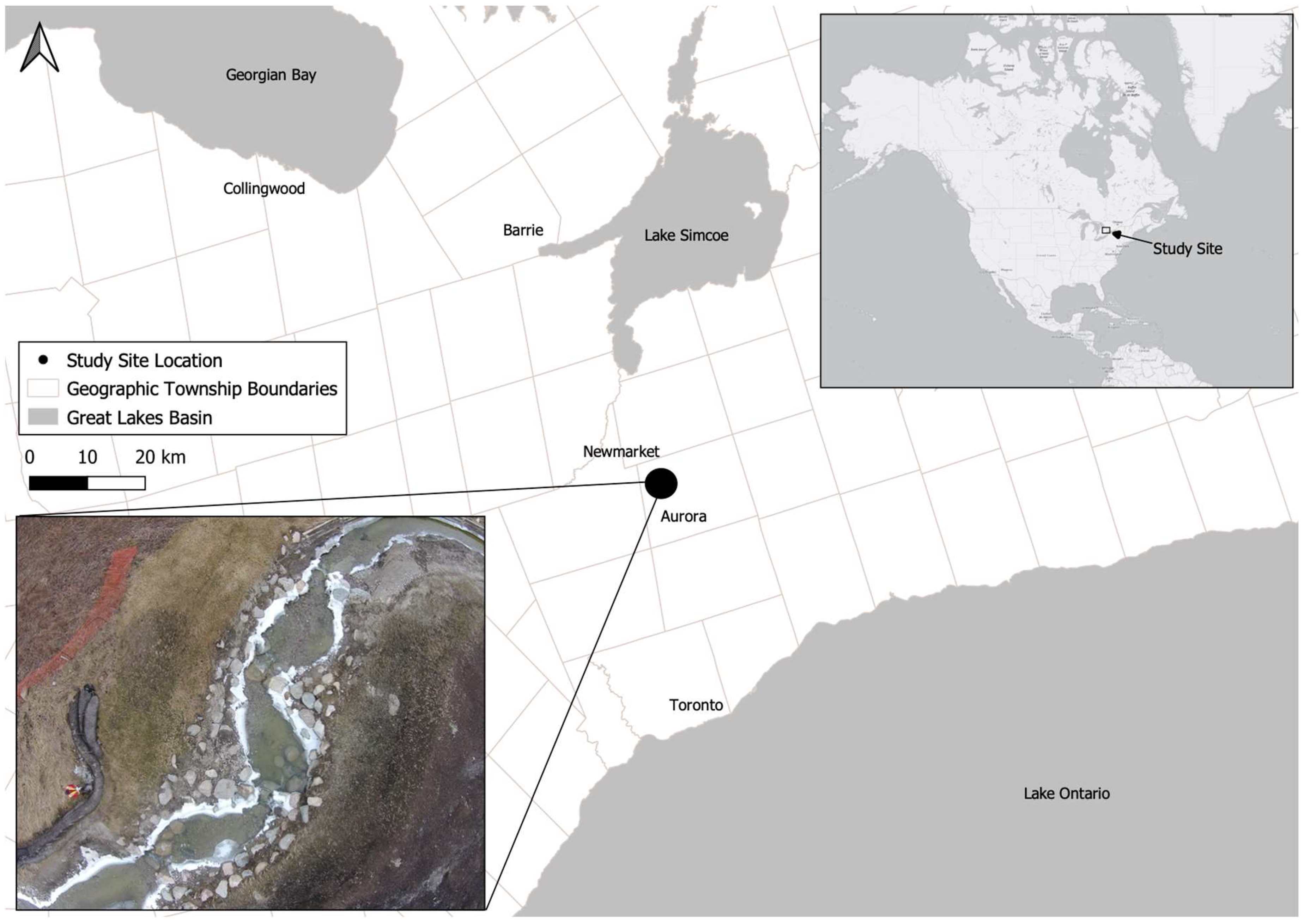
Figure 1.
Study site location in Aurora, Ontario, Canada. A restored section of Weslie Creek, including 10 VRWs (aerial photograph of four subject VRWs and associated pools is shown in the lower left corner), was selected for evaluating small-bodied fish passage suitability.
Figure 1.
Study site location in Aurora, Ontario, Canada. A restored section of Weslie Creek, including 10 VRWs (aerial photograph of four subject VRWs and associated pools is shown in the lower left corner), was selected for evaluating small-bodied fish passage suitability.

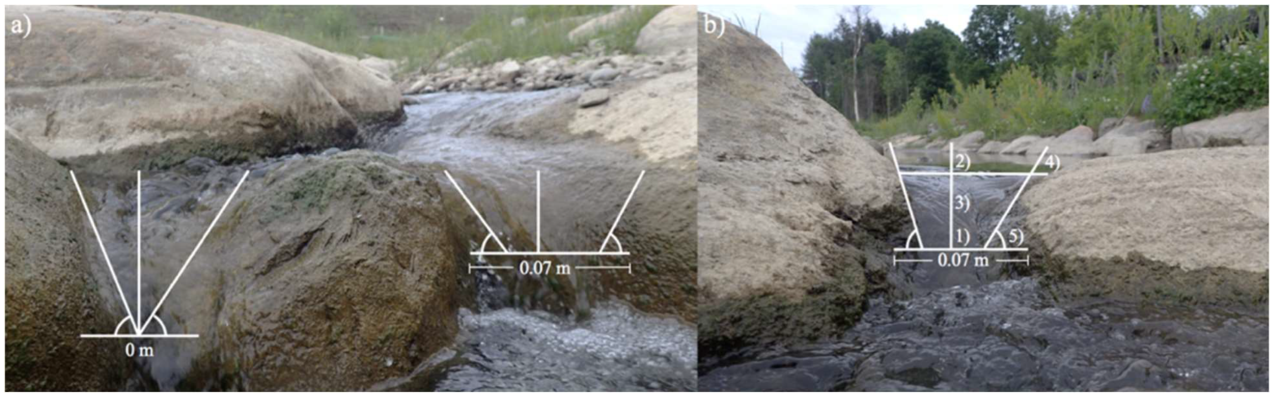
Figure 2.
(a) Potential gap geometries for the VRWs at Weslie Creek. The left gap demonstrates a triangular gap, while the right gap demonstrates a trapezoidal gap. (b) Gap geometry measurements were collected for the base width (1), top width (2), gap water level (3), keystone height (4), and keystone angle (5).

Figure 3.
Daily rainfall, daily water temperature, and hourly water level along the study reach. Upper and lower temperature limits for fish species local to Weslie Creek are labeled on the water temperature graph [24]. Key field assessment days are shown with diamonds along the lower x-axis.
Figure 3.
Daily rainfall, daily water temperature, and hourly water level along the study reach. Upper and lower temperature limits for fish species local to Weslie Creek are labeled on the water temperature graph [24]. Key field assessment days are shown with diamonds along the lower x-axis.

Figure 4.
Reach profile from upstream (left) to downstream (right), with representative pool (above the profile line) and VRW (below the profile line) cross-sections. The asterisk in the pool 7 cross-section shows the location of the stilling well used. Vertical exaggeration is 0.08 m.
Figure 4.
Reach profile from upstream (left) to downstream (right), with representative pool (above the profile line) and VRW (below the profile line) cross-sections. The asterisk in the pool 7 cross-section shows the location of the stilling well used. Vertical exaggeration is 0.08 m.

Figure 5.
Fish passability in low, intermediate, and high water level conditions. VRWs that provide 100% fish passability are represented by green keystones, VRWs that provide fish passage for 4 or fewer fish species are represented by yellow keystones, and VRWs that do not provide gap or over-weir flow pathways are represented by red keystones. Note that red keystones allow orifice flow and leaping opportunities for fish passage. Further, recirculation zones indicate potential locations for fish refuge during unsuitable swimming conditions.

Figure 6.
Fish passability results under low, intermediate, and high water level conditions. Fish passage suitability is based on the number of fish species that are able to pass upstream based on velocities throughout the gap and over-weir flow pathways (i.e., if the velocity is suitable for all 5 local fish species, there is 100% fish passability). In many cases, there are multiple flow pathways throughout a VRW, and as such, opportunities for faster-swimming small-bodied fish species to move upstream are available (i.e., VRW3 under all water level conditions).

Figure 7.
Profile schematics of a (a) low-gradient VRW and (b) high-gradient VRW. The difference in gradient depicts how the embeddedness changes depending on how gentle or steep the channel bed is. A greater level of embeddedness provides upstream and downstream connectivity without obstructions to the flow path (b).


Table 1.
Small-bodied fish species in Weslie Creek [24] and corresponding physiological and behavioral characteristics [28].
| Genus | Species | Common Name | Adult Length (m) | Burst Swim Speed (m/s) | Preferred Temperature Range (°C) | Vertical Leaping Capability (m) * |
|---|---|---|---|---|---|---|
| Cottus | bairdi | Mottled sculpin | 0.07–0.10 | 0.84 | 18 | 0.35–0.50 |
| Rhinichthys | atralutus | Blacknose dace | 0.07–0.10 | 0.69 | 19–25 | 0.35–0.50 |
| Semotilus | atromaculatus | Creek chub | 0.08–0.20 | 0.44 | 20.8 | 0.40–1.00 |
| Pimephalse | promelas | Fathead minnow | 0.05–0.07 | 0.55 | 23–29 | 0.25–0.35 |
| Culaea | inconstans | Brook Stickleback | 0.04–0.07 | 0.89 ** | 21.3 | 0.25–0.35 |
Note(s): * Based on adult length.** Based on three-spine stickleback swimming characteristics (brook stickleback swimming characteristics are unknown).
Table 2.
Total fish passage suitability (passability) based on the VRW gradient.
| VRW | Gradient | % Passability at Low Water Levels | % Passability at Intermediate Water Levels | % Passability at High Water Levels |
|---|---|---|---|---|
| 1 | −0.01 | 100 | 100 | 100 for ≤ 4 species |
| 2 | −0.02 | 0 * | 100 for ≤ 4 species | 100 for ≤ 4 species |
| 3 | −0.02 | 100 | 100 for ≤ 4 species | 100 for ≤ 4 species |
| 4 | −0.05 | 100 | 100 for ≤ 4 species | 100 |
| 5 | −0.10 | 100 | 100 | 100 |
| 6 | −0.08 | 100 | 100 for ≤ 4 species | 100 |
| 7 | −0.14 | 100 | 100 | 100 |
| 8 | −0.09 | 100 | 100 | 100 |
| 9 | −0.05 | 100 | 100 | 100 for ≤ 4 species |
| 10 | −0.06 | 100 | 100 for ≤ 4 species | 100 |
Note(s): * Fish passage opportunities exist through leaping or orifice flow pathways, based on visual observations of small-bodied fish species upstream.
Table 3.
Pool length influences fish passage suitability (passability) through the downstream VRW and available locations for fish refuge.
Table 3.
Pool length influences fish passage suitability (passability) through the downstream VRW and available locations for fish refuge.
| Pool | Length (m) | Pool Depth (m) * | Total Number of Locations for Fish Refuge under All Water Level Conditions |
|---|---|---|---|
| 1 | 7.40 | 0.14 | 0 |
| 2 | 2.30 | 0.10 | 1 |
| 3 | 2.40 | 0.11 | 1 |
| 4 | 3.60 | 0.11 | 1 |
| 5 | 11.20 | 0.17 | 34 |
| 6 | 3.90 | 0.13 | 15 |
| 7 | 3.80 | 0.20 | 5 |
| 8 | 2.50 | 0.16 | 20 |
| 9 | 20.70 | 0.25 | 23 |
| 10 | 5.90 | 0.20 | 26 |
| 11 | 2.40 | 0.25 | 19 |
Note(s): * Measured in the thalweg during low water level conditions to provide a conservative value for fish habitat suitability.
Table 4.
Total fish passability based on VRW width, number of keystones, and sizes of the keystones.
Table 4.
Total fish passability based on VRW width, number of keystones, and sizes of the keystones.
| VRW | VRW Crest Width (m) | # Keystones | Range of Keystone Sizes (m) | % Passability at Low Water Levels | % Passability at Intermediate Water Levels | % Passability at High Water Levels |
|---|---|---|---|---|---|---|
| 1 | 1.9 | 5 | 0.2–1.8 | 100 | 100 | 100 for ≤ 4 species |
| 2 | 3.1 | 8 | 0.4–1.1 | 0 * | 100 for ≤ 4 species | 100 for ≤ 4 species |
| 3 | 2.2 | 4 | 0.6–0.8 | 100 | 100 | 100 for ≤ 4 species |
| 4 | 2.4 | 3 | 0.6–1.3 | 100 | 100 for ≤ 4 species | 100 |
| 5 | 3.6 | 9 | 0.5–1.0 | 100 | 100 | 100 |
| 6 | 3.5 | 9 | 0.6–1.1 | 100 | 100 for ≤ 4 species | 100 |
| 7 | 3.3 | 8 | 0.2–1.1 | 100 | 100 | 100 |
| 8 | 3.5 | 9 | 0.2–1.3 | 100 | 100 | 100 |
| 9 | 2.7 | 6 | 0.3–0.7 | 100 | 100 | 100 for ≤ 4 species |
| 10 | 2.5 | 7 | 0.2–10 | 100 | 100 for ≤ 4 species | 100 |
Note(s): * Fish passage opportunities exist through leaping or orifice flow pathways, based on visual observations of small-bodied fish species upstream.
Disclaimer/Publisher’s Note: The statements, opinions and data contained in all publications are solely those of the individual author(s) and contributor(s) and not of MDPI and/or the editor(s). MDPI and/or the editor(s) disclaim responsibility for any injury to people or property resulting from any ideas, methods, instructions or products referred to in the content. |
© 2023 by the authors. Licensee MDPI, Basel, Switzerland. This article is an open access article distributed under the terms and conditions of the Creative Commons Attribution (CC BY) license (https://creativecommons.org/licenses/by/4.0/).
Share and Cite
MDPI and ACS Style
Mielhausen, J.; Cockburn, J.M.H.; Villard, P.V.; Baril, A.-M. Balancing Physical Channel Stability and Aquatic Ecological Function through River Restoration. Water 2023, 15, 1799. https://doi.org/10.3390/w15091799
AMA Style
Mielhausen J, Cockburn JMH, Villard PV, Baril A-M. Balancing Physical Channel Stability and Aquatic Ecological Function through River Restoration. Water. 2023; 15(9):1799. https://doi.org/10.3390/w15091799
Chicago/Turabian StyleMielhausen, Josie, Jaclyn M. H. Cockburn, Paul V. Villard, and André-Marcel Baril. 2023. "Balancing Physical Channel Stability and Aquatic Ecological Function through River Restoration" Water 15, no. 9: 1799. https://doi.org/10.3390/w15091799
Note that from the first issue of 2016, this journal uses article numbers instead of page numbers. See further details here.