Trails for everyone, forever

Home Go Hiking Hiking Guide Naches Peak Loop

Naches Peak Loop

Mount Rainier Area > SE - Cayuse Pass/Stevens Canyon
46.8674, -121.5176 Map & Directions
Length
3.2 miles, roundtrip
Elevation Gain
600 feet
Highest Point
5,850 feet
Calculated Difficulty About Calculated Difficulty
Easy/Moderate

Closed for the winter season: Chinook Pass/SR 410 between Crystal Mountain Blvd and Morse Creek; all but the southernmost 2.5 miles of Cayuse Pass/SR 123.

High mountain meadow showcasing Mount Rainier. Photo by Jim Correll. Full-size image
  • Dogs not allowed
  • Fall foliage
  • Good for kids
  • Lakes
  • Mountain views
  • Wildflowers/Meadows

Parking Pass/Entry Fee

Northwest Forest Pass
Saved to My Backpack

This popular hike provides a range of alpine experiences in a short loop. Walk along a hillside above a small valley, pause at a viewpoint overlooking a lake, and stroll through grassy meadows with stunning views of Mount Rainier. In season enjoy an abundance of wildflowers or perhaps a handful of huckleberries. Continue reading

Rating
4.52 out of 5

(75 votes) Log in to rate

Hiking Naches Peak Loop

This popular hike provides a range of alpine experiences in a short loop. Walk along a hillside above a small valley, pause at a viewpoint overlooking a lake, and stroll through grassy meadows with stunning views of Mount Rainier. In season enjoy an abundance of wildflowers or perhaps a handful of huckleberries.

The hike follows the Pacific Crest Trail on the northern flank of Naches Peak and the Naches Peak Trail on the southern flank. The loop is best done clockwise for outstanding views of Mount Rainier.

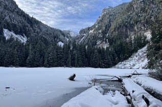
This hike begins at Tipsoo Lake and then traverses a steep hillside on the northern flank of Naches Peak. As you climb a gentle slope, you will look down on a small lush valley that is a wildflower heaven. In late July and early August you may be treated to a flower festival including blue lupine, white bistort, and magenta paintbrush. Along the way you will pass an unnamed lakelet where you may be tempted to take off your boots and go wading.

As the loop wraps around the east side of Naches Peak, the trail comes to a viewpoint with Dewey Lake over 600 feet below. The smooth rock bench here makes an excellent place to eat lunch or take a break. This is a popular place, however, so be prepared to share the experience with others.

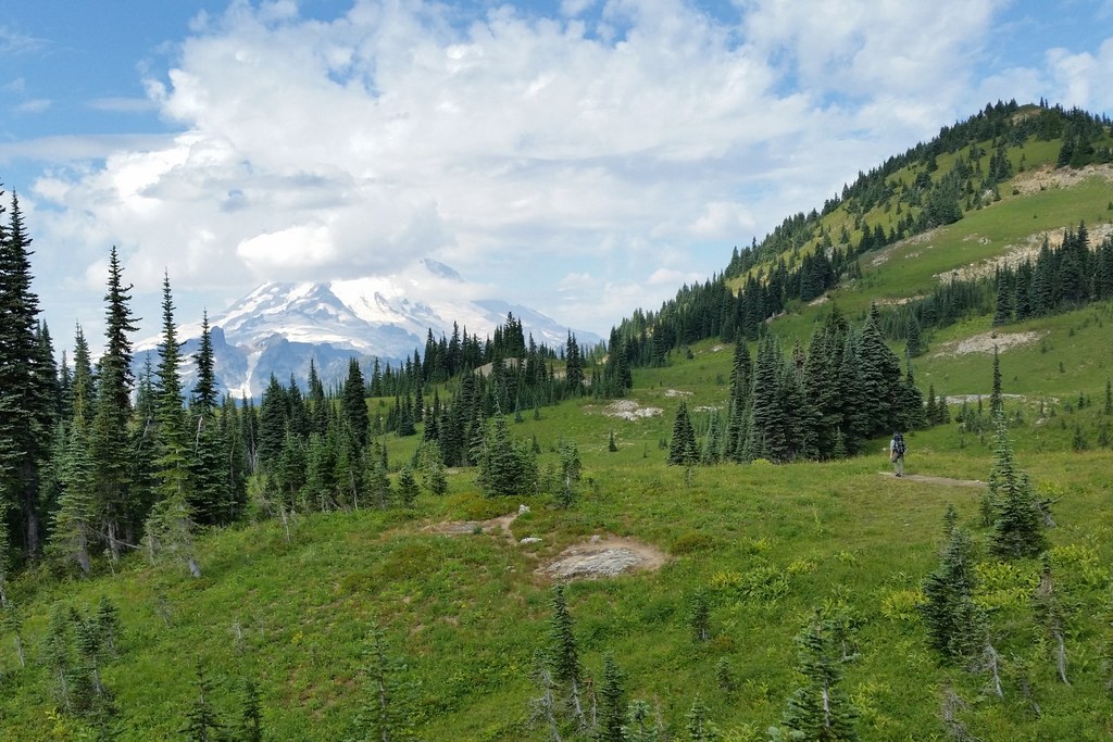
Just after the Dewey Lake viewpoint, the Pacific Crest Trail comes to a junction with the Naches Peak Loop trail. Go right and follow the trail along the southern side of Naches Peak,where you will cross alpine meadows with stunning views of Mount Rainier. This is an exceptionally picturesque area, and it is easy to get fantastic photos here. Many people feel this is the highlight of the loop. Follow this trail back to the Tipsoo Lake parking lot to complete your loop.

Note on dogs: Part of this trail is on National Forest land and part in the National Park. Mount Rainier does not allow dogs, so if you do have your four-legged hiking companion with you, please consult a map and note where your canine friend is able to hike, and where they'll have to stay behind. You can also find other locations in the Mount Rainier Area that are dog friendly by consulting our Hiking Guide

Toilet Information

  • Toilet at trailhead

More information about toilets

WTA worked here in 2023 and 2022!

Hike Description Written by
Patricia Coulthard, WTA Correspondent

Naches Peak Loop

Map & Directions

Trailhead
Co-ordinates: 46.8674, -121.5176 Open in Google Maps

Before You Go

Closed for the winter season: Chinook Pass/SR 410 between Crystal Mountain Blvd and Morse Creek; all but the southernmost 2.5 miles of Cayuse Pass/SR 123.

See weather forecast

Parking Pass/Entry Fee

Northwest Forest Pass

WTA Pro Tip: Save a copy of our directions before you leave! App-based driving directions aren't always accurate and data connections may be unreliable as you drive to the trailhead.

Getting There

From the ranger station in Enumclaw, drive east on State Route 410 (Chinook Pass Highway) about 44 miles. Half a mile before (west of) Chinook Pass, park at the Tipsoo Lake parking area. Facilities are available at the Tipsoo Lake parking area. Note: This trailhead does not require a parking permit.

This trail can also be accessed via the Chinook Pass Overlook Trailhead. This trailhead is 0.7 miles to the east of the Tipsoo Lake parking area along State Route 410. The parking area is on the west side of the street. This trailhead does require a Northwest Forest Pass to park. 

More Hike Details

Trailhead

Mount Rainier Area > SE - Cayuse Pass/Stevens Canyon

Pacific Crest Trail (#TR 2000)

Mount Rainier National Park

Guidebooks & Maps

Day Hiking: Mount Rainier National Park Trails - by Dan A. Nelson and Alan L. Bauer

Best Loop Hikes in Washington - by Dan A. Nelson and Alan L. Bauer

50 Hikes in Mount Rainier National Park - by Ira Spring & Harvey Manning

100 Classic Hikes in Washington - by Ira Spring & Harvey Manning

Buy the Green Trails Mt Rainier East No. 270 map

Buy the Green Trails Bumping Lake No. 271 map

You can improve or add to this guidebook entry!

Naches Peak Loop

1031 Trip Reports

Hiked here recently?

Submit a trip report!
 
Trip Reports